

Oklahoma map
Bartlesville map
About 38,355 people live here (Census Bureau, 2024 estimate). The sheet's index lists 300 streets; Southeast Washington Boulevard, Ira Lee Henderson Memorial Highway and East Tuxedo Boulevard cross the most grid squares. Also on it: Bartlesville Municipal Airport, Adams Golf Course and ConocoPhillips/Phillips 66.
Open the map (PDF, US Letter)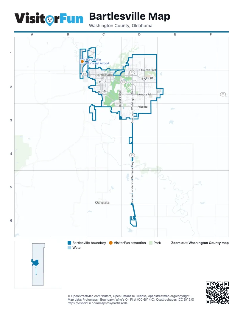
Street index of Bartlesville
Each street on the sheet and the grid squares it crosses.
- Ira Lee Henderson Memorial HighwayD4, D5, D6
- Southeast Washington BoulevardD1, D2, D3, D4
- Southeast Adams BoulevardC2, D2
- Nowata RoadC2, D2
- Northeast Washington BoulevardD1
- West Adams BoulevardC2
- Southwest Adams BoulevardC2
- Western DriveC2
- Southeast Nowata RoadD2
- Bartlesville RoadC2
- WesternC2
- East Tuxedo BoulevardC1, D1, C2
- Southeast Frank Phillips BoulevardC2, D2
- South Madison BoulevardD2
- Madison BoulevardD1, D2, D3
- Southwest Frank Phillips BoulevardC2
- West Hensley BoulevardC2
- East Hensley BoulevardC2
- Southeast Cherokee AvenueC2
- Southeast Madison BoulevardD1, D2
- Bartles RoadC2
- Frank Phillips Memorial HighwayC2
- Silver Lake RoadC2, D2, C3
- Price RoadC3, D3
- Hillcrest DriveC2, C3
- South Keeler AvenueC2
- Sunset BoulevardC1
- South Johnstone AvenueC2
- Southeast Bison RoadD2
- South Shawnee AvenueC2
- Southwest Jennings AvenueC2
- Northwest Lupa StreetC1
- N3940 RoadC1
- N3990 RoadD2
- South Armstrong AvenueC2
- Oak Park RoadC1
- West 5th StreetC2
- Southeast Wilshire AvenueD1, D2
- North Virginia AvenueC1, C2
- South Virginia AvenueC2
- Swan DriveD2
- East 11th StreetC2
- South Choctaw AvenueC2
- West 11th StreetC2
- Southport DriveD3
- Brentwood RoadC1
- South Quapaw AvenueC2
- East Frank Phillips BoulevardD2
- Moose Lodge RoadD4
- South JohnstoneC2
- Southeast Adams RoadD2
- West 4th StreetC2
- West 14th StreetC2
- East 18th StreetC2
- Southeast Delaware AvenueC2
- Beck DriveD1, D2
- Shawnee AvenueC2
- South Comanche AvenueC2
- South Sunset BoulevardC2
- East 14th StreetC2
- West 18th StreetC2
- North Sunset BoulevardC1, C2
- Virginia AvenueC2
- Southeast Green Country RoadD2
- South Cherokee AvenueC2
- East 20th StreetC2
- Larchmont DriveC1
- North Quapaw AvenueC2
- Burch AvenueD2
- Keeler AvenueC2
- 14th StreetC2
- Green Country RoadD2
- South Osage AvenueC2
- Minnesota StreetD1
- Woodland RoadD2
- South Dewey AvenueC2
- Southeast Kentucky StreetD2
- Southeast Greystone AvenueD2
- Baylor DriveD2
- East 4th StreetC2, D2
- Rice Creek RoadD3
- Cudahy StreetC2
- Stonewall DriveC2, D2
- Southwest Oak AvenueC2
- Oakdale DriveC2, D2
- Harvard DriveD2
- South Hickory AvenueC2
- West 2100 RoadC3
- South Rogers AvenueC2
- Cornell DriveD2
- Southwest Santa Fe AvenueC2
- South Elm AvenueC2
- Camelot DriveD3
- Lariat DriveD2
- South Maple AvenueC2
- South Penn AvenueC2
- Arbor DriveD2
- East DriveD2
- Southeast Seneca AvenueC2
- Skyline DriveC2, C3
- Harned DriveD2
- Jefferson RoadD2, D3
- Nebraska StreetD1
- East 5th StreetC2
- East Mountain RoadC3
- Southview AvenueC2
- Southeast Elmhurst AvenueD2
- Fairview RoadD2
- State StreetD2
- Quail Ridge RoadD2
- Macklyn LaneD2
- Kingston DriveD3
- Cherokee Hills DriveC2, D2
- Michigan StreetD1
- East 8th StreetC2
- Southeast Dewey AvenueC2
- Sheridan RoadD2
- Southeast Hampden RoadC3
- Northeast Spruce AvenueD1
- Herrick StreetC1
- Mountain RoadC3
- Jefferson PlaceD2, D3
- Indiana StreetD1
- Wayside DriveD2
- Grandview RoadD2
- East 13th StreetC2
- Southeast Hazel RoadD2
- Barlow DriveD2
- Wisconsin StreetD1
- Delaware AvenueC2
- Harris DriveD2
- Industrial BoulevardD2, E2
- West 6th StreetC2
- East 9th StreetC2
- Harvey RoadD2, D3
- West 15th StreetC2
- Glynnwood DriveC3
- May LaneD2
- Southeast Manor DriveD2
- Evergreen DriveD2
- South Wyandotte AvenueC2
- Northeast Elmhurst AvenueD1
- West 13th StreetC2
- Northeast Wilshire AvenueD1
- Bridle RoadD2
- Edgewood AvenueD1, D2
- Barnett AvenueD2, D3
- Ohio StreetD1
- Melmart DriveD2
- Wiley Post RoadB1, B2
- South Chickasaw AvenueC2
- Mountain DriveC3
- Claremont DriveD3
- Montrose DriveD3
- South Creek AvenueC2
- Brookside ParkwayD2
- Kane Hill DriveC3
- Lincoln RoadD2
- Yale DriveD2
- Meadow DriveD2
- Rolling Meadows RoadD2
- Will Rogers DriveB1, C1
- Highland DriveC1
- Prairie Heights DriveD2
- Lahoma DriveC1
- Park Hill DriveD1
- Georgetown DriveC3, D3
- Meadow LaneD2
- South Morton AvenueC2
- South Bucy AvenueC2
- Northeast Fenway AvenueD1
- Sooner Park DriveD2
- Meadowlark AvenueD1
- Limestone RoadD2
- Northeast Myers AvenueD1
- Brookhollow LaneD2
- Northwest MargariteC1, C2
- West 9th StreetC2
- North Woodrow AvenueC1, C2
- Cambridge CourtD3
- Southeast Queenstown AvenueD2
- Southeast Rockwood AvenueD1, D2
- Sooner RoadC1
- Katherine AvenueD1
- Southeast Morningside AvenueD1, D2
- Colorado AvenueC2
- Southeast Avondale AvenueD1, D2
- Southeast Waverly AvenueD1, D2
- Forrest Park RoadC1
- West 16th StreetC2
- Crown DriveD2
- East 16th StreetC2
- Interurban DriveD1
- Southeast Brookline DriveD2
- Victory WayD2
- Turkey Creek RoadD2
- Castle RoadD2
- Southeast Fenway PlaceD1, D2
- Southwest Adeline AvenueC2
- Chapel Hill RoadC3, D3
- Mistletoe LaneC1
- South West Mountain RoadC3
- Southwest Armstrong AvenueC2
- West 8th StreetC2
- West 2nd StreetC2
- Crescent DriveD2
- Southeast Fleetwood DriveD2
- Winding WayD2
- Putnam DriveD2
- Crestland DriveD2
- Barbara StreetD1
- Dorchester DriveC3, D3
- Southeast State StreetD2
- West 10th StreetC2
- Roanoke Ridge RoadD3
- Lester AvenueD2
- South Cheyenne AvenueC2
- Circle DriveC3
- Nova AvenueD2, D3
- Southwest Cass AvenueC2
- Parkview DriveC1
- Northwest Theodore AvenueC1, C2
- Northeast de Bell AvenueD1
- Northeast Avondale AvenueD1
- Northeast Roselawn AvenueD1
- Cherokee PlaceC2
- Douglas LaneD2
- Saddle LaneD2
- Henrietta AvenueD3
- Northwest Santa Fe AvenueC1, C2
- Northeast Cummings AvenueD1
- North Bucy AvenueC1, C2
- Amherst DriveD2
- North Kaw AvenueC1, C2
- North Rogers AvenueC1, C2
- North Seminole AvenueC1, C2
- Kansas LaneD1
- Lindenwood DriveC1
- Northeast Queenstown AvenueD1
- Ridgewood RoadD2
- Smysor DriveD2
- Kenwood DriveD2
- Kensington WayD3
- Northeast Ohio StreetD1
- Wurmbrand WayD2
- Coventry LaneC2
- Carol RoadC1
- Nowata PlaceC2, D2
- Southeast de Bell AvenueD1, D2
- Dorsett DriveD2
- Brookline DriveD2
- Clearview DriveD2
- Lee DriveD2
- Concord DriveD2
- Regency RoadD3
- Hill DriveC3, D3
- Southeast 8th StreetC2
- Kings WayD2
- Rolling Hills DriveD2
- Southeast Whitney LaneD2
- Braddock RoadD3
- Northwest Adeline AvenueC1, C2
- Moonlight DriveC2
- Southeast Princeton DriveD2
- Spring RoadC1
- West 20th StreetC2
- South Seminole AvenueC2
- Stonehenge DriveD2
- East 2nd StreetC2
- Southeast Fenway AvenueD1, D2
- East 12th StreetC2
- Southwest Oklahoma AvenueC2
- Polaris DriveC2
- Belmont RoadD2
- Park LaneC2
- Ramblewood RoadC1
- Jacquelyn LaneD2
- Dartmouth DriveD2
- North Morton AvenueC1, C2
- West 12th StreetC2
- Bluestem RoadD2
- McKinley RoadD2
- Cheyenne AvenueC1, C2
- Prairie Ridge DriveD1
- Williamsburg StreetD3
- Southeast Spruce AvenueD1, D2
- Richmond DriveD2
- Guinn LaneD2
- Westview DriveC3
- Rockwood AvenueD1
- Cumberland DriveC1
- Fleetwood DriveD2
- London LaneC3, D3
- Southeast King DriveD2
- North Johnstone AvenueC1, C2
- Willowood DriveD2
- Young AvenueD1
- Palmetto DriveC1
- Park Hill LoopD1
- Woodland LoopD2
Places on the map
- A's Wine and Spirits
- Acorn Storage
- Adams Boulevard Church of Christ
- Adams Golf Course
- ALDI
- Arby's
- Arvest Bank
- ASAP General Store
- Atwoods
- AutoZone
- Avondale Mini Storage
- Axis Healthcare
- Bank of Oklahoma
- Bargain Center, Inc.
- Bartlesville Area History Museum
- Bartlesville Bruins Activity Center
- Bartlesville Chrysler Dodge Ram Jeep
- Bartlesville Library
- Bartlesville Lodge AF & AM
- Bartlesville Municipal Airport
- ConocoPhillips/Phillips 66
- Jane Phillips Medical Center
- Jo Allyn Lowe Park
- Johnstone Park
- Kiddie Park
- Memorial Park Cemetery
- Oak Park School
- Price Baseball-Softball Fields
- Robinwood Park
- Sooner Park
- Southtown Center
- THE KP TRAIN
- The Mound
- Voice of the Martyrs
- Washington Park Mall
- White Rose Cemetery
Next to Bartlesville
- Ochelata
© OpenStreetMap contributors, Open Database License, openstreetmap.org/copyright · Map data: Protomaps · Boundary: Who's On First (CC-BY 4.0); Quattroshapes (CC BY 2.0)















