

Oklahoma map
Washington County map
About 54,060 people live here (Census Bureau, 2024 estimate). The sheet's index lists 300 streets; N3990 Road, N4000 Road and N4030 Road cross the most grid squares. Also on it: Adams Golf Course, Burlingame Number 2 Reservoir and Copan.
Open the map (PDF, US Letter)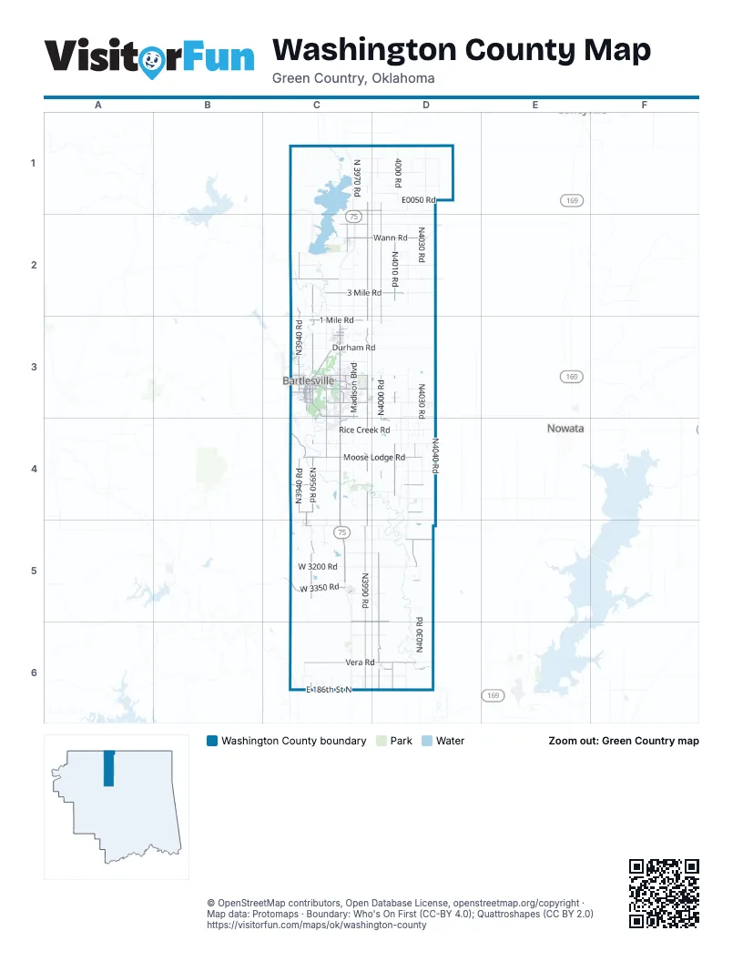
Maps inside Washington County
1 map inside, from the street map of Washington County down.
Street index of Washington County
Each street on the sheet and the grid squares it crosses.
- Ira Lee Henderson Memorial HighwayC4, C5
- Southeast Washington BoulevardC3, C4
- Vera RoadC6, D6
- 3 Mile RoadC2, D2
- Wann RoadC2, D2
- West 3350 RoadC5
- Southeast Adams BoulevardC3
- East 186th Street NorthC6, D6
- Nowata RoadC3, D3
- South Osage AvenueC3
- North Osage AvenueC3
- Indian RoadC1, D1
- Well RoadC2
- Northeast Washington BoulevardC3
- Washington BoulevardC3
- West Adams BoulevardC3
- Southwest Adams BoulevardC3
- Baker RoadC1
- Western DriveC3
- Southeast Nowata RoadC3
- Bartlesville RoadC3
- WesternC3
- East Tuxedo BoulevardC3
- Southeast Frank Phillips BoulevardC3
- Bartles RoadC3
- South Madison BoulevardC3
- Madison BoulevardC3, C4
- Southwest Frank Phillips BoulevardC3
- West Hensley BoulevardC3
- East Hensley BoulevardC3
- Southeast Cherokee AvenueC3
- Frank Phillips Memorial HighwayC3
- East Durham AvenueC3
- Southeast Madison BoulevardC3
- Main StreetD2
- North Cincinnati Avenue EastC6
- N3990 RoadC1, C2, C3, C4, C5, C6
- N4000 RoadD1, D2, D3, D4, D5, D6
- N3950 RoadC2, C3, C4, C5, C6
- N4010 RoadD2, D3, D4, D6
- N3940 RoadC2, C3, C4, C5
- Moose Lodge RoadC4, D4
- Silver Lake RoadC3, C4
- West 3000 RoadD5, C6, D6
- 1 Mile RoadC3
- N4025 RoadD4, D5
- Southeast Bison RoadC3, C4
- 4 Mile RoadC2
- West 2600 RoadC4, D4
- Price RoadC3
- 3940 RoadC4
- Hillcrest DriveC3
- West 2800 RoadC4, D4
- West 3950 RoadC5, D6
- South Keeler AvenueC3
- South Shawnee AvenueC3
- South Johnstone AvenueC3
- West 2400 RoadC4
- North Caney AvenueC2
- Sunset BoulevardC3
- Southwest Jennings AvenueC3
- East 11th StreetC3
- Northwest Lupa StreetC3
- West 14th StreetC3
- West 5th StreetC3
- N3930 RoadC4
- South Armstrong AvenueC3
- Oak Park RoadC3
- Southeast Wilshire AvenueC3
- North Virginia AvenueC3
- South Virginia AvenueC3
- Swan DriveC3
- South Caney AvenueC2
- Shawnee AvenueC3, C5
- South Choctaw AvenueC3
- 14th StreetC3
- West 11th StreetC3
- East Don Tyler AvenueC3
- East Golden AvenueC2
- Southport DriveC4
- Brentwood RoadC3
- E0300 RoadD5
- South Ochelata StreetC4, C5
- E0110 RoadD2
- South Cherokee AvenueC3
- South Quapaw AvenueC3
- North Ochelata StreetC4
- East Frank Phillips BoulevardC3
- South JohnstoneC3
- Southeast Adams RoadC3
- West 4th StreetC3
- East 18th StreetC3
- Southeast Delaware AvenueC3
- Beck DriveC3
- South Comanche AvenueC3
- South Sunset BoulevardC3
- East South StreetC5
- East 14th StreetC3
- West 18th StreetC3
- North Sunset BoulevardC3
- Keeler AvenueC3
- 1100 RoadC2
- Virginia AvenueC3
- Southeast Green Country RoadC3
- East 20th StreetC3
- Larchmont DriveC3
- North Quapaw AvenueC3
- Burch AvenueC3
- West Don Tyler AvenueC3
- West 1100 RoadC2
- Golden AvenueC2
- County Road 2300C5
- Green Country RoadC3
- N4030 RoadD1, D2, D3, D4, D5, D6
- N4020 RoadD1, D2, D3, D4, D5, D6
- N4040 RoadD1, D2, D3, D4, D6
- N3980 RoadC2, C3, C4, C5
- Rice Creek RoadC4, D4
- West 3200 RoadC5, D5
- N3960 RoadC2, C3, C4, C5
- West 400 RoadC1, D1
- Durham RoadC3, D3
- West 2300 RoadC4, D4
- North 4000 RoadD1, D4, D6
- North 3970 RoadC1
- West 2700 RoadC4, D4
- Cotton Valley RoadC1, D1
- West 1500 RoadC3, D3
- West 200 RoadC1, D1
- North 4020 RoadD1, D3
- West 1600 RoadC3, D3
- West 1300 RoadC2, D2
- County Road 1200D1
- E0050 RoadD1
- Tuxedo BoulevardC3, D3
- E0100 RoadC2, D2
- E0070 RoadD2
- Minnesota StreetC3
- West 3400 RoadC5, D5
- West 900 RoadC2, D2
- West 2500 RoadC4, D4
- E0220 RoadD4
- N3945 RoadC2
- E0210 RoadD3
- West 2100 RoadC3, D3
- 2 Mile RoadC2
- E0120 RoadD2
- N4015 RoadD3, D4
- West 450 RoadC1, D1
- West 2650 RoadC4, D4
- West 600 RoadD1
- 9th StreetC3, D3
- West 2900 RoadC5, D5
- West 3500 RoadD5
- Woodland RoadC3
- West 1000 RoadC2, D2
- North 4010 RoadD1, D4
- N3995 RoadD1
- South Dewey AvenueC3
- North 4028 DriveD4
- 1400 RoadC3, D3
- East 4th StreetC3
- CR N3970C5
- North 4015 RoadD4
- Cranor RoadC4
- North 3950 RoadC3, C4
- West 1400 RoadC3, D3
- Southeast Kentucky StreetC3
- East 5th StreetC3
- West 3900 RoadD6
- Southeast Greystone AvenueC3
- North 3995 RoadC5, D5
- Baylor DriveC3
- West 1900 RoadD3
- W700 RoadC2, D2
- North Creek AvenueC3
- 3963 RoadC5
- Philson Farm RoadC4
- East 9th StreetC3
- Cudahy StreetC3
- East Mountain RoadC3, C4
- Stonewall DriveC3
- West 9th StreetC3
- Old Caney HighwayC1, C2
- North Wyandotte AvenueC3
- Delaware AvenueC3, C5
- Southwest Oak AvenueC3
- Oakdale DriveC3
- South Hickory AvenueC3
- North Choctaw AvenueC3
- Harvard DriveC3
- South Rogers AvenueC3
- Cornell DriveC3
- Southwest Santa Fe AvenueC3
- South Elm AvenueC3
- North 3944 RoadC6
- North Ross AvenueC3
- 4020 RoadD1
- Yorman RoadC4
- North Bison RoadC3
- Camelot DriveC4
- S4040 RoadD6
- West 300 RoadD1
- Road 39C3
- Bison RoadC3
- East Adams BoulevardC3, D3
- E0060 RoadD1
- Lariat DriveC3
- South Maple AvenueC3
- West 700 RoadC2, D2
- East Durham RoadC3
- South Penn AvenueC3
- Arbor DriveC3
- East DriveC3
- 3980 RoadC1
- North Cherokee AvenueC3
- North 3954 DriveC6
- Southeast Seneca AvenueC3
- North 3990 RoadD1
- Skyline DriveC3
- 5 Mile RoadC2
- North Delaware StreetC3, D6
- Harned DriveC3
- West E03300 RoadC5
- Jefferson RoadC3
- West 3945 RoadC4, C6
- West 4060 DriveC6
- South 4040 RoadD6
- State StreetC3, D6
- Nebraska StreetC3
- North Shawnee AvenueC3
- West 6th StreetC3
- North 4000 DriveD3
- North 3979 WayC4
- Indiana StreetC3
- Southview AvenueC3
- Portland AvenueC3
- Southeast Elmhurst AvenueC3
- Fairview RoadC3
- W2880 DriveC5
- Quail Ridge RoadC3
- Split Rock RoadC4
- Macklyn LaneC3
- N4005 RoadD4
- Kingston DriveC4
- East 2nd StreetC3
- Cherokee Hills DriveC3
- Michigan StreetC3
- South Wyandotte AvenueC3
- East 8th StreetC3
- West 2750 RoadC4, D4
- Southeast Dewey AvenueC3
- Sheridan RoadC3
- Southeast Hampden RoadC4
- West 1970 DriveD3
- Northeast Spruce AvenueC3
- Herrick StreetC3
- Longacre DriveC6
- Mountain RoadC4
- Jefferson PlaceC3
- 4th StreetC3, C5
- Wayside DriveC3
- North 3960 RoadC1, C6
- South Creek AvenueC3
- Grandview RoadC3
- North 4034 DriveD4
- North 3945 RoadC6
- East 13th StreetC3
- Southeast Hazel RoadC3
- Barlow DriveC3
- Wisconsin StreetC3
- East 16th StreetC3
- Harris DriveC3
- Industrial BoulevardC3
- Harvey RoadC3
- West 15th StreetC3
- Johnson StreetC2
- Glynnwood DriveC3
- West 2550 RoadD4
- May LaneC3
- Patridge RoadC3
- Southeast Manor DriveC3
- Evergreen DriveC3
- Northeast Elmhurst AvenueC3
- West 13th StreetC3
- Northeast Wilshire AvenueC3
- State Barn RoadC4
- Bridle RoadC3
- Edgewood AvenueC3
- Barnett AvenueC3
- 4010 RoadD1
- South Chickasaw AvenueC3
- Ohio StreetC3
- South Seminole AvenueC3
- Melmart DriveC3
- West 4000 RoadC6
- Mountain DriveC3, C4
- West Weldon AvenueC2
- Cass StreetC5
- East 12th StreetC3
Places on the map
- Adams Golf Course
- Blue Mound
- Burlingame Number 2 Reservoir
- ConocoPhillips/Phillips 66
- Copan
- Copan Lake
- Copan Point
- DCH Annex Ultralight Flightpark
- Dewey
- Dewey Cemetery
- Don Tyler Park
- Double Creek Site 1 Reservoir
- Double Creek Site 2 Reservoir
- Double Creek Site 3 Reservoir
- Double Creek Site 6 Reservoir
- Dutcher D.B. Reservoir
- Flying Eagle Estates Airport
- G C Richardson Reservoir
- Jane Phillips Medical Center
- Jo Allyn Lowe Park
- Johnstone Park
- Kiddie Park
- Lake Todd
- Memorial Park Cemetery
- Oak Park School
- Ochelata
- Ochelata Lake
- Orville Quinn Number 2 Reservoir
- Pat Murphy Pond
- Price Baseball-Softball Fields
- Ramona
- Richard Kane Reservoir
- Sooner Park
- Tie-In-Club Lake
- Turkey Creek Reservoir
- Vera
- Voice of the Martyrs
- Washington Park Mall
Next to Washington County
- Nowata
© OpenStreetMap contributors, Open Database License, openstreetmap.org/copyright · Map data: Protomaps · Boundary: Who's On First (CC-BY 4.0); Quattroshapes (CC BY 2.0)















