

Oklahoma map
Chickasha map
About 17,014 people live here (Census Bureau, 2024 estimate). The sheet's index lists 281 streets; Harry E. Bailey Turnpike, West Country Club Road and South 24th Street cross the most grid squares. Things to do inside the boundary: Visit Chickasha.
Open the map (PDF, US Letter)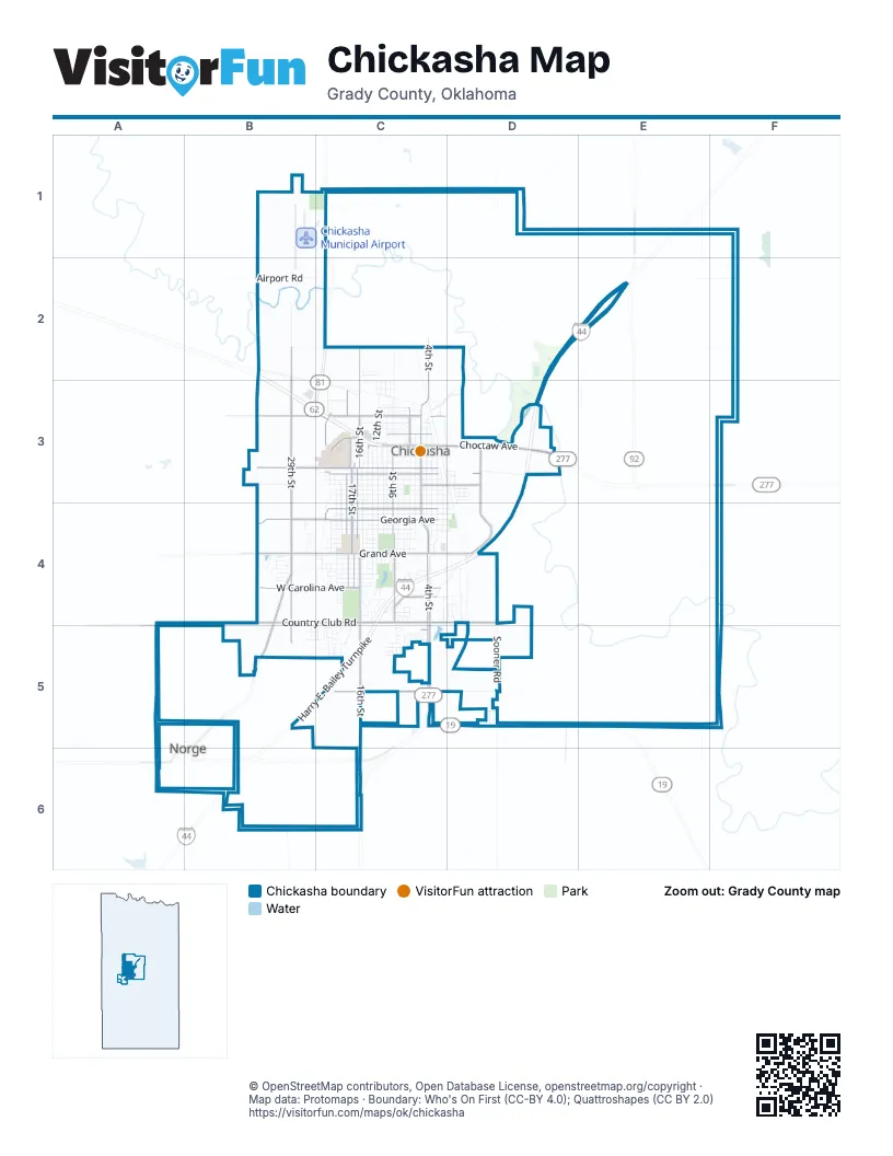
Street index of Chickasha
Each street on the sheet and the grid squares it crosses.
- E1320 RoadB1, C1
- N2840 RoadC1, C3
- N2850 RoadD1
- N2860 RoadD1, D2
- Chickasha AvenueE1
- Harry E. Bailey TurnpikeE1, D2, E2, D3, C4, D4, B5, C5, B6
- Maple RoadE1, F4
- 29th StreetB2
- Airport RoadB2, C2
- County Road 1340B2, C2
- North 29th StreetB2, B3
- Old US Highway 62B2, B3, C3
- 1st StreetC2
- 2nd StreetC2
- 3rd StreetC2
- North 16th StreetC2, C3
- North 4th StreetC2, C3
- North 9th StreetC2, C3
- Ballard RoadF2
- Miller RoadF2
- 1360 County RoadB3
- Frisco AvenueB3, C3
- South 29th StreetB3, B4, B5
- West Idaho AvenueB3, C3
- West Iowa AvenueB3, C3
- Apache StreetC3
- Charles Allen DriveC3
- Colorado AvenueC3
- Cottonwood DriveC3
- D1345 RoadC3, D3
- Dan Allen DriveC3
- Dan Allen RoadC3
- East Ada Sipuel AvenueC3, D3
- East Choctaw AvenueC3, D3
- East Dakota AvenueC3, D3
- East Iowa AvenueC3, D3
- East Minnesota AvenueC3, D3
- East Oregon AvenueC3
- East Texas AvenueC3, D3
- East Washington AvenueC3, D3
- El Reno AvenueC3
- Factory StreetC3
- Fred McClain AvenueC3
- Harrison DriveC3
- Honda LaneC3
- John Cowan DriveC3
- Lawton AvenueC3
- Maryland AvenueC3
- North 10th StreetC3
- North 11th StreetC3
- North 12th StreetC3
- North 13th StreetC3
- North 14th StreetC3
- North 17th StreetC3
- North 18th StreetC3
- North 1st StreetC3
- North 2nd StreetC3
- North 3rd StreetC3
- North 5th StreetC3
- North 6th StreetC3
- North 7th StreetC3
- North 8th StreetC3
- North Genevieve StreetC3
- North Industrial BoulevardC3
- Railroad StreetC3, D3
- South 10th StreetC3, C4
- South 11th StreetC3, C4
- South 12th StreetC3, C4
- South 13th StreetC3, C4
- South 14th StreetC3, C4
- South 15th StreetC3, C4
- South 16th StreetC3, C4, C5
- South 17th StreetC3, C4
- South 18th StreetC3, C4
- South 19th StreetC3, C4
- South 1st StreetC3, C4
- South 20th StreetC3, C4
- South 21st StreetC3, C4
- South 22nd StreetC3, C4
- South 2nd StreetC3, C4
- South 3rd StreetC3, C4
- South 4th StreetC3, C4, C5
- South 5th StreetC3, C4
- South 6th StreetC3, C4
- South 7th StreetC3, C4
- South 8th StreetC3, C4
- South 9th StreetC3, C4
- South Genevieve StreetC3, D3
- South Sheppard StreetC3, C4
- Vermont AvenueC3
- West Ada Sipuel AvenueC3
- West Chickasha AvenueC3
- West Choctaw AvenueC3
- West Colorado AvenueC3
- West Dakota AvenueC3
- West Delaware AvenueC3
- West Harvey StreetC3
- West Illinois AvenueC3
- West Kansas AvenueC3
- West Michigan AvenueC3
- West Minnesota AvenueC3
- West Ohio AvenueC3
- West Oklahoma AvenueC3
- West Oregon AvenueC3
- West Pennsylvania AvenueC3
- West SpencerC3
- West Texas AvenueC3
- West Washington AvenueC3
- Carpenter DriveD3, F3
- Coyyor Research RoadD3, D4
- E1345 RoadD3
- East Elm AvenueD3
- East Maple AvenueD3
- East Oak AvenueD3
- East Walnut AvenueD3
- South Douglas StreetD3
- South Franklin StreetD3
- South Grand AvenueD3, D4
- South Henderson StreetD3, D4
- South Jackson StreetD3, D4
- Tollbridge RoadD3
- Friend RoadF3
- West Country Club RoadA4, B4, C4, A5
- 30th StreetB4
- 34th StreetB4
- Arizona AvenueB4, C4
- Bobwhite LaneB4
- California AvenueB4, C4
- Diamond DriveB4
- Hill StreetB4, B5
- Lakewood DriveB4
- Miller DriveB4
- Mississippi StreetB4
- Mockingbird LaneB4, B6
- Norge RoadB4, B5
- Opal StreetB4
- Pearl StreetB4, C4
- Skyview DriveB4
- South 24th StreetB4, C4, B5, C5
- South 25th StreetB4, B5
- South 33rd StreetB4
- Todd Estates DriveB4
- UniversityB4
- West Carolina AvenueB4, C4
- West Georgia AvenueB4, C4
- West Grand AvenueB4, C4
- West Montana AvenueB4, C4
- West Park AvenueB4, C4
- 9th Street CircleC4
- Arlington RoadC4
- Avalon DriveC4
- Basin StreetC4
- Belmont DriveC4
- Briar CreekC4
- Brookridge StreetC4, C5
- Catalpa DriveC4
- Caulder DriveC4, C5
- Cemetery RoadC4
- Cherry DriveC4
- Chisholm DriveC4
- Christopher DriveC4
- Circle DriveC4
- Country Club DriveC4
- Cranton DriveC4
- Desirae DriveC4
- Dickenson DriveC4, B5, C5
- East Alabama AvenueC4
- East Almar DriveC4, D4
- East Arkansas AvenueC4, D4
- East Country Club RoadC4, D4
- East Florida AvenueC4, D4
- East Georgia AvenueC4, D4
- East Grand AvenueC4, D4
- East Missouri AvenueC4, D4
- East Tennessee AvenueC4, D4
- East Virginia AvenueC4, D4
- Elmhurst DriveC4
- Elmview DriveC4
- Fairlawn AvenueC4
- Ferguson RoadC4
- Flanders DriveC4, C5
- Glenwood DriveC4
- Grand TerraceC4
- Hazlewood AvenueC4
- Hillcrest DriveC4
- MapleC4
- Maple DriveC4
- Maple LaneC4
- Maple wood AvenueC4
- Marynell RoadC4
- Meadowdale DriveC4
- Morningside DriveC4
- Morrow DriveC4
- Nichols RoadC4
- Park AvenueC4
- Ponderosa DriveC4, D4
- Pondridge RoadC4, C5
- Ridgecrest DriveC4
- Riviera DriveC4
- Rosewood DriveC4, C5
- Saint Charles PlaceC4
- Saint James PlaceC4
- Shannon DriveC4
- Shannon Springs ParkC4
- Sheridan PlaceC4, C5
- Skyline DriveC4
- Sleepy Hollow BoulevardC4, C5
- South 22ndC4
- South 23rd StreetC4, C5
- South 8th Street CircleC4
- Stewart DriveC4
- Sunny LaneC4
- Taft DriveC4
- Telegraph DriveC4
- Timber CourtC4
- Utah AvenueC4
- Village DriveC4
- West Alabama AvenueC4
- West Almar DriveC4
- West Arkansas AvenueC4
- West Florida AvenueC4
- West Highland DriveC4
- West Louisiana AvenueC4
- West Mississippi AvenueC4
- West Missouri AvenueC4
- West Nevada AvenueC4
- West Orchard DriveC4
- West Tennessee AvenueC4
- West Utah AvenueC4
- West Virginia AvenueC4
- West Wisconsin AvenueC4
- Willow Brook DriveC4
- Wood Ponds DriveC4
- Woodbin AvenueC4
- Woods LaneC4
- Alli CircleD4
- E1370 RoadD4
- Grand AvenueD4
- Heatherwood DriveD4
- Lacey DriveD4
- Sooner RoadD4, D5
- Valley View DriveD4
- Farris PlaceB5, C5
- MockingbirdB5
- State Highway 92B5, A6
- Vine StreetB5
- Bowerwood DriveC5
- Brook Hollow DriveC5
- Brookpark LaneC5
- Cottonwood RoadC5, D5, F5
- Dunhill DriveC5
- Dusky Valley DriveC5
- Fieldcrest DriveC5
- Gibson DriveC5
- Glenda Way DriveC5
- Hazy Brooks DriveC5
- Hickory Stick DriveC5
- Lazywood DriveC5
- McKenzie DriveC5
- Misty Glenn DriveC5
- Parkway DriveC5
- Pikes Peak RoadC5
- Pleasant LaneC5
- Ruskin PlaceC5
- Shady Meadow WayC5
- Sleepy Hollow DriveC5
- Stoney Brook DriveC5
- Willow Creek RoadC5
- Gatewood DriveD5
- Glenhaven DriveD5
- Pond RoadD5
- Quail RoadD5, C6
- Robin LaneD5
- Sterling DriveD5
- Windsor DriveD5
- Union Hill RoadE5
- Willow RoadE5
- Wyatt RoadA6
- E1410 RoadB6
- D2835 RoadC6
- N2830 RoadC6
Things to do on the Chickasha map
Places on the map
- 12th Street Park
- ALDI
- Ampitheatre
- Austin Park
- Best Western Plus
- Canadian River Brewing Co
- Canadian Valley Technology Center
- Centennial Plaza
- Centennial/Kids Place Park
- Chickasha Bowling Center
- Chickasha City Hall
- Chickasha Golf & Country Club
- Chickasha High School
- Chickasha Municipal Airport
- Chickasha Police Dept.
- Chickasha Public Library
- Fair Lawn Cemetery
- Fairfield Inn & Suites Chickasha
- First Presbyterian Church
- Grady Memorial Hospital
- Hampton Inn Chickasha
- Hart Trailers
- Heritage Park Theater
- Holy Name of Jesus Catholic Church
- Legends Pub House & Venue
- Love's
- MidFirst Bank
- Oknoname 051049 Reservoir
- Richie Park
- Rose Hill Cemetery
- Shannon Springs Park
- Soccer Field
- Soccer Practice Field
- Super 8 by Wyndham Chickasha
- Tennis Courts
- The Chief Drive-In Theatre
- The Shoppes at Chisholm Trail
- Trinity Baptist Church
- U.S. Post Office Chickasha
- Washita Valley Park
Next to Chickasha
- Norge
© OpenStreetMap contributors, Open Database License, openstreetmap.org/copyright · Map data: Protomaps · Boundary: Who's On First (CC-BY 4.0); Quattroshapes (CC BY 2.0)















