

Oklahoma map
Grady County map
About 58,353 people live here (Census Bureau, 2024 estimate). The sheet's index lists 300 streets; Cemetery Road, 1st Street and Harry E. Bailey Turnpike cross the most grid squares. Things to do inside the boundary: SaltCreek Casino, Tiger Safari Zoological Park and Visit Chickasha.
Open the map (PDF, US Letter)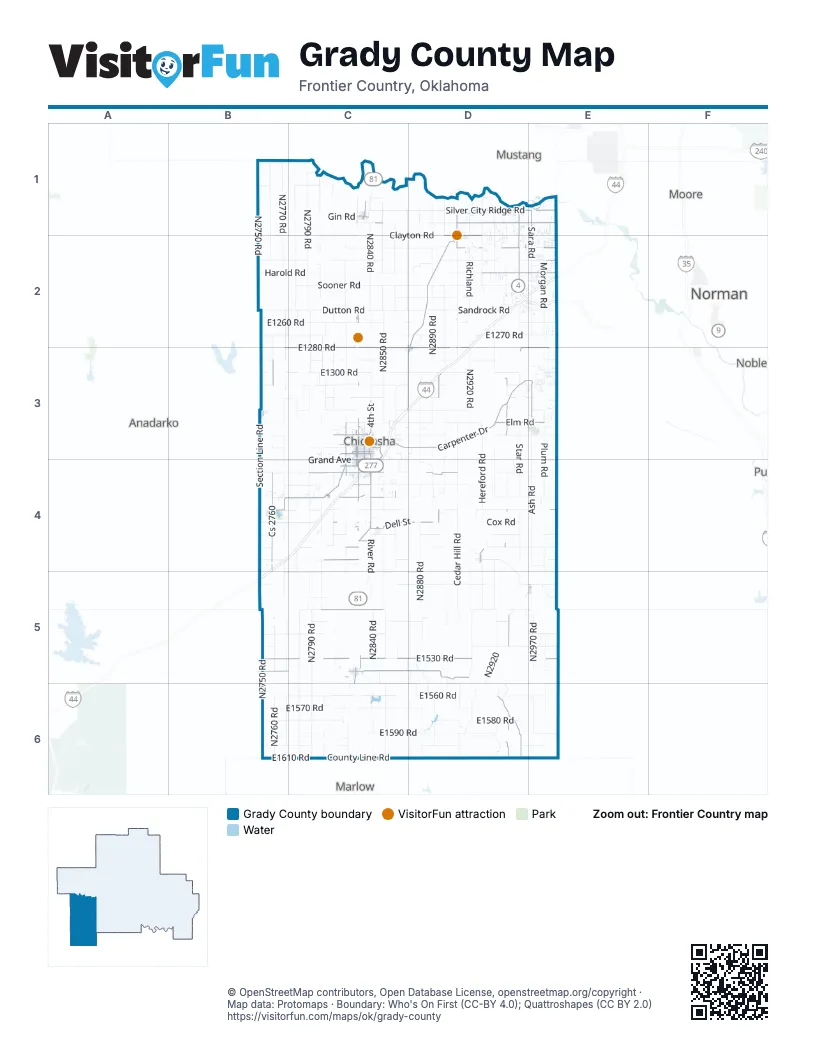
Street index of Grady County
Each street on the sheet and the grid squares it crosses.
- Harry E. Bailey TurnpikeD2, E2, C3, D3, B4, C4, B5
- Harry E. Bailey Turnpike SpurD2, E2
- E1530 RoadB5, C5, D5, E5
- Carpenter DriveC3, D3
- Elm RoadD3, E3, D4
- Mustang RoadD1, D2
- South 4th StreetC3, C4
- Rocky Ford RoadC5
- East Silver City Ridge RoadD1
- North 4th StreetC3, C4
- Main StreetC2, C3, D3, C4, D4, E5
- Rowell RoadC4
- East Main StreetD1, D3
- East Choctaw AvenueC3
- Northwest 3rd StreetC1, D1
- West Choctaw AvenueC3
- Valley View RoadC4
- South Mustang RoadD1, D2
- North Mustang RoadD1
- Half Penny RoadC4
- West Main StreetD1
- Southwest 3rd StreetC1, D1, D2
- Northwest Main StreetC1
- Dan Allen RoadC3
- Sager RoadC1
- Mockingbird RoadC4
- Little Valley LaneC4
- Chestnut DriveC4
- Northeast Main StreetC1
- West Veterns Memorial HighwayE3
- Southwest Boardwalk StreetD2
- Chickasha AvenueD2, C3, D3
- West Grand AvenueC4
- South 29th StreetC3, C4
- North 29th StreetC3
- Rush AvenueC5, C6
- Blakeley AvenueC5
- Southwest 4th StreetC1, D1, D2
- Georgia AvenueD2, D3
- E1280 RoadB3, C3, D3, E3
- County Line RoadE2, E3, E4, E5, B6, C6, E6
- Cs 2760B3, B4
- N2950 RoadD3, D4, D5, D6
- East Tyler DriveD1, E1
- Cox City RoadC5, D6
- State Highway 92B4, C4
- Old Highway 62D3, E3
- Fox RoadD2, E2
- West Country Club RoadC4
- North County Line RoadE1, E2
- Dell StreetC4, D4
- Old US Highway 81C3, C4
- E1540 RoadB5, C5, D5
- South 16th StreetC3, C4
- County Street 2970E3
- Rock Creek RoadD2, E2
- N2895 RoadD3, D4, D5
- Highway 17C5, D5
- Frisco AvenueC3
- Quail RoadC4
- South 17th StreetC3, C4
- Silver City Ridge RoadD1, E1
- West Iowa AvenueC3
- West Georgia AvenueC3
- South 9th StreetC3, C4
- Norge RoadC4
- North Sara RoadE1
- North Cimmaron RoadD1
- N2830 RoadC3, C4, C5
- West Missouri AvenueC3
- West Minnesota AvenueC3
- South 18th StreetC3, C4
- North 16th StreetC3
- West Carolina AvenueC4
- Pikes Peak RoadC4
- E1545 RoadC5, D5
- East 1545 RoadD5
- West Illinois AvenueC3
- South Cimarron RoadD1, D2
- Coyyor Research RoadC3
- South Sara RoadE1, E2
- East Grand AvenueC3, C4
- East Country Club RoadC4
- North Main StreetB3, D4
- Northwest 16th StreetE2
- 3rd StreetC2, C3, D3, C4, E5
- West Almar DriveC4
- North 6th StreetC3
- East Ada Sipuel AvenueC3
- South Main StreetB3, D4
- North 18th StreetC3
- D2835 RoadC4
- Lake Burtschi RoadB4
- County Line AvenueE4
- South Grand AvenueC3, C4
- 180th StreetE4
- Center AvenueC4
- West Ada Sipuel AvenueC3
- Ellis AvenueC4
- Southwest 16th StreetE2
- West Fox LaneE2
- West Highway 277C4
- Northwest 24th StreetE2
- N2790 RoadC1, C2, C3, C5, C6
- N2770 RoadB1, B2, B3, B4, B5, B6
- N2840 RoadC1, C2, C3, C5, C6
- N2850 RoadC2, C3, C4, C5, C6
- N2760 RoadB1, B2, B3, B5, B6
- Sooner RoadC2, D2, C4, C5
- N2750 RoadB1, B2, B4, B5, B6
- N2780 RoadC1, C2, C3, C5, C6
- E1300 RoadB3, C3, D3
- N2880 RoadD2, D3, D4, D5, D6
- N2920 RoadD2, D3, D4, D5, D6
- N2800 RoadC1, C2, C3, C5, C6
- Dutton RoadB2, C2, D2
- N2820 RoadC2, C3, C4, C5, C6
- E1570 RoadB6, C6, D6, E6
- Cemetery RoadC1, C2, D2, C3, C4, D4, C5, D5
- Harold RoadB2, C2, D2, E2
- E1270 RoadB2, C2, D2, E2
- E1590 RoadB6, C6, D6, E6
- E1560 RoadB6, C6, D6
- N2890 RoadD1, D2, D3, D4, D6
- Ash RoadE3, E4
- N2900 RoadD2, D3, D4, D5, D6
- N2870 RoadC2, D3, D4, D5, D6
- E1580 RoadB6, C6, D6
- N2940 RoadD2, D3, D5, D6
- Sandrock RoadD2, E2
- Star RoadD3, D4
- River RoadC4, D4, E4, C5
- N2810 RoadC1, C2, C3, C5, C6
- Maple RoadD3, D4
- Clayton RoadC1, D1
- E1510 RoadB5, C5, D5, E5
- Cedar Hill RoadD4, D5
- Cs 2790C1, C2, C3, C4, C6
- Leonard B Scott RoadC2, D2
- E1470 RoadC5, D5
- E1610 RoadB6, C6, D6
- E1550 RoadB6, C6, D6, E6
- Cottonwood RoadC4, D4
- County Road 1400B4, D4, E4
- E1260 RoadB2, C2, D2
- N2980 RoadE2, E3, E5, E6
- N2970 RoadE2, E5, E6
- Cs 2780C4, C5, C6
- Plum RoadE3, E4
- Cimarron RoadD2
- Red Bird RoadD3, D4
- Malcolm RoadC1, C2
- Section Line RoadB3, B4
- N2860 RoadC2, C3, C4
- E1290 RoadC3, D3
- Bridge Creek RoadD2
- E1320 RoadB3, C3, D3, E3
- Morgan RoadE1, E2
- E1500 RoadC5, D5
- Hereford RoadD3, D4
- RichlandD2
- Chisholm Trail RoadC1, C2
- Miller RoadD3, D6
- Williams PlaceD5, E5
- E1330 RoadC3, D3
- E1310 RoadC3, D3, E3
- County Road 1600C6, D6, E6
- Rabbit RoadD2
- Hawkins RoadD4, E4
- E1210 RoadB2, C2, E2
- N2910 RoadD2, D4, D6
- West Silver City Ridge RoadD1
- Kiowa RoadC2
- Grand AvenueB4, C4
- E1600 RoadB6, C6, D6, E6
- N1240 RoadC2, D2
- 4 Mile RoadC3
- Alex HighwayD3, D4
- Chitwood ExpresswayD4, D5
- Robbins RoadC1, C2
- Friend RoadC3, D3
- North Frisco RoadD1, D2
- Czech Hall RoadD1, D2
- West Sooner RoadC2
- County Road 1420B4, C4, D4
- E1490 RoadC5, D5, E5
- Oak RoadD3, E3
- Creek 1390B4, C4
- Cs 2770B4
- Sara RoadE2
- Mockingbird LaneD2, C3, C4
- North Boundary StreetB3, D5, E5
- Chisolm TrailC4
- Cs 2910D2, D3, D6
- Old Fred's RoadC4
- N2920D5, D6
- Pioneer RoadD2, C4
- East Rock Creek RoadD2, E2
- East 1560 RoadD6, E6
- County Road 1340C3, D3
- North Morgan RoadE1
- N2960 RoadD2, D3
- Cs 2880D3, D4
- Lucile RoadD3, D4
- E1190 RoadB1, C1, C2
- E1410 RoadB4, C4, D4
- County Street 2800C2
- Cost 2780C1
- North 2970 RoadE6
- Lucille RoadD3
- Jack Hollow RoadC2
- Chaparrall RoadD5
- Quail Haven RoadD2, E2
- Mellegaard RoadE4, E5
- County Road 1380C4, D4, E4
- Cox RoadD4
- Chitwood RoadC4, D4, C5, D5
- Ballard RoadD3
- Old Bradley HighwayD4, D5
- Cardinal RoadC2, C4
- Fox LaneD2
- 7th StreetD2, E3, C5, D5, E5, B6
- North Gregory RoadD1
- County Road 1580C6, D6
- Creek 1380B4, C4
- E1400 RoadC4, D4
- 1st StreetC2, B3, C3, D3, C4, D4, C5, D5
- E1460 RoadC5, D5
- Gin RoadC1
- TimberlandD5
- E1450 RoadB4, C4, D4, E4
- Taylor Lake RoadC6
- Creek 1590C6, D6
- N2802 RoadC2, C3
- Snow Hill RoadE2, E3
- North Cemetery RoadD1
- Cs 2800C1, C3, C4
- 89th Street SouthwestB1, C1
- West Tyler DriveD1
- Field Work RoadD1
- Arena RoadC3, C4
- South 19th StreetC3, C4
- Cs 2890D4, D6
- East Sooner RoadD2, E2
- 5th StreetC2, D2, B3, C4, C5, E5
- Creek 1340B3, E3
- E1480 RoadC5
- Smith RoadD3
- E1440 RoadC4, D4
- Trail RoadD4
- Frisco RoadD2
- N2930 RoadD6
- Moss RoadE4
- 7 Mile LineE2
- Peach StreetC4
- Black RoadD4
- County Road 1410B4, C4
- WallaceD5
- D2885 RoadD5, D6
- County Road 1450B4
- North Richland RoadD1
- Timber RoadD5
- N2990 RoadE2, E3, E5
- Giles RoadC3
- Creek 2770B3, B4
- West Idaho AvenueC3
- South 13th StreetC3, C4
- South 1st StreetC3, C4, C5
- 1320 County RoadB3, C3
- East 1530 RoadC5
- 6th StreetC2, D2, B3, C5, D5, E5
- South 14th StreetC3, C4
- South 12th StreetC3, C4
- Old US Highway 62C3
- Willow RoadD4
- Lincoln RoadD4
- South 6th StreetC1, C3, C4, D4
- South Chitwood RoadD5
- West Dakota AvenueC3
- Cr 1280D3
- County Road 1310B3, C3
- County Road 1440B4, D4
- South 15th StreetC3, C4
- WyanttC4, C5
- Sunny Lane RoadC5
- Timbers RoadE2
- Airport RoadC3
- S Morgan AveE3
- 2nd StreetB3, C3, D3, C4, D4
- South 20th StreetC3, C4
- West Florida AvenueC3
- E1520 RoadB5, E5
- South 5th StreetC3, C4, D4
- West Washington AvenueC3
- E1170 RoadC1, D1
- Northwest 10th StreetC1, E3
- E1240 RoadE2
- West Arkansas AvenueC3
- Creek 1420B4
- West Tennessee AvenueC3
Things to do on the Grady County map
Places on the map
- Alex
- Alex High School
- Amber
- Bitter Creek Site 1 Reservoir
- Bitter Creek Site 20 Reservoir
- Bitter Creek Site 3 Reservoir
- Bitter Creek Site 4 Reservoir
- Bitter Creek Site 6 Reservoir
- Bitter Creek Site 8b Reservoir
- Bityter Creek Site 9 Reservoir
- Blanchard
- Bradley
- Bridge Creek
- Chickasha
- Chickasha Golf & Country Club
- Chickasha High School
- Chickasha Municipal Airport
- Grady Memorial Hospital
- Lake Louis Burtschi
- Lake Louis Burtschi State Game Reservation
- Martinbird Tree Farm
- Minco
- Ninnekah
- Norge
- Oknoname 051022 Reservoir
- Oknoname 051023 Reservoir
- Oknoname 051041 Reservoir
- Pocasset
- River Bend North Nine
- River Bend South Course
- Roaring Creek Site 4 Reservoir
- Roaring Creek Site 9 Reservoir
- Rush Creek Site 17 Reservoir
- Rush Creek Site 19 Reservoir
- Rush Creek Site 24 Reservoir
- Rush Springs
- Taylor Lake
- Tuttle
- Verden
- Winter Creek Golf Course
Next to Grady County
- Anadarko
- Marlow
- Moore map
- Mustang
- Noble
- Norman map
© OpenStreetMap contributors, Open Database License, openstreetmap.org/copyright · Map data: Protomaps · Boundary: Who's On First (CC-BY 4.0); Quattroshapes (CC BY 2.0)