

Oklahoma map
Frontier Country map
The sheet's index lists 32 highways; I-40, I-44 and US 270 cross the most grid squares. Things to do inside the boundary: American Banjo Museum, Apothecary Garden and Bricktown. Also on it: Chandler, Chickasha and Cushing.
Open the map (PDF, US Letter)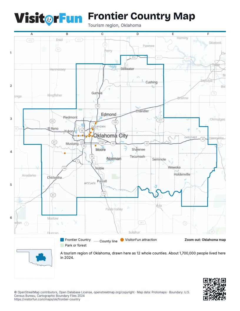
Highway index of Frontier Country
Each highway on the sheet and the grid squares it crosses.
- I-35C1, C2, C3, C4, C5
- I-40A3, B3, B4, C3, C4, D4, E4, F4
- I-44A5, B3, B4, B5, C3, C4, D3, E3
- I-235C3, C4
- I-240B4, C4
- I-335C3, C4
- I-344B3, B4, C3
- US 62B4, B5, C3, C4, F4
- US 75F4
- US 77C2, C3, C4
- US 81B3, B4, B5, B6
- US 177D4
- US 270A3, B3, B4, C3, C4, D4
- US 277B5
- US 281A3
- US 377E3, E4, E5
- US 412D1
- OK 3B3, B4, C4, D4
- OK 3ED4, E4, E5
- OK 3WD4
- OK 4B4
- OK 8A3
- OK 9B4, B5, C4, D4
- OK 19B5
- OK 37B4
- OK 59E4
- OK 66B3, C3
- OK 74B3
- OK 99E3, E4, E5
- OK 102D4
- OK 152B4
- OK 312D1
Things to do on the Frontier Country map
- American Banjo Museum
- Apothecary Garden
- Bricktown
- Cattlemen's Steakhouse
- Factory Obscura
- First Americans Museum
- Fred Jones Jr. Museum of Art
- H&H Shooting Sports
- Lake Thunderbird State Park
- Mabee-Gerrer Museum of Art
- Museum of Osteology
- Myriad Botanical Gardens
- National Cowboy & Western Heritage Museum
- Newcastle Casino
- NorthPark Mall
- OKC Outlets
- Oklahoma City Museum of Art
- Oklahoma City National Memorial
- Oklahoma City Tourism Information Center
- Oklahoma City Zoo and Botanical Garden
- Oklahoma Contemporary Arts Center
- Oklahoma History Center
- Oklahoma Native Art & Jewelry
- Oklahoma River Cruises
- Penn Square Mall
- Pops 66
- Quail Springs Mall
- RIVERSPORT OKC
- Riverwind Casino
- SaltCreek Casino
- Sam Noble Oklahoma Museum of Natural History
- Science Museum Oklahoma
- Scissortail Park
- Six Flags Frontier City
- Sooner Mall
- Tener's Western Outfitters
- Tiger Safari Zoological Park
Places on the map
- Chandler
- Chickasha
- Cushing
- Edmond
- El Reno
- Guthrie
- Holdenville
- Moore
- Mustang
- Noble
- Norman
- Oklahoma City
- Piedmont
- Purcell
- Seminole
- Shawnee
- Stillwater
- Tecumseh
- Wewoka
- Yukon
Next to Frontier Country
© OpenStreetMap contributors, Open Database License, openstreetmap.org/copyright · Map data: Protomaps · Boundary: U.S. Census Bureau, Cartographic Boundary Files 2024