

Oklahoma map
Choctaw map
About 12,358 people live here (Census Bureau, 2024 estimate). The sheet's index lists 297 streets; North Henney Road, Northeast 50th Street and North Choctaw Road cross the most grid squares. Also on it: Bouse Park, Choctaw Creek and Choctaw Creek Park.
Open the map (PDF, US Letter)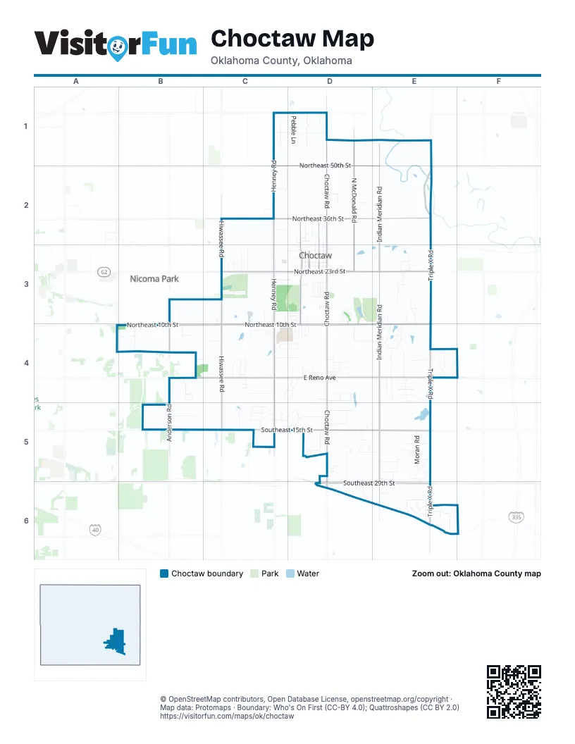
Street index of Choctaw
Each street on the sheet and the grid squares it crosses.
- North Henney PlaceC1
- North Henney RoadC1, C2, C3, C4
- North Vargas RoadC1, C2
- Northeast 50th StreetC1, D1, E1, E2
- Northeast 57th StreetC1, D1
- Northeast 63rd StreetC1
- T Davis DriveC1
- Alice DriveD1
- Joseph DriveD1
- Joseph StreetD1
- North Choctaw RoadD1, D2, D3, D4
- North McDonald RoadD1, D2, D3
- Pebble LaneD1
- North Indian Meridian RoadE1, E2, E3, E4
- Brown StreetC2
- East Vargas RoadC2
- Moore DriveC2
- North Hiwassee RoadC2, C3, C4
- North Ridge CourtC2
- North Ridge DriveC2
- Northeast 36th StreetC2, D2, E2
- Washington BoulevardC2
- Youngs DriveC2
- Champions GlenD2
- Clarke StreetD2, D3
- Cox CircleD2
- Cox StreetD2
- Dean StreetD2
- EffieD2
- Effie StreetD2
- Elizabeth StreetD2
- Fox Creek ParkwayD2
- Fox Creek RoadD2
- Fox Hollow RoadD2
- Fox Ridge RoadD2
- Harper StreetD2, D3, D4
- Katherine StreetD2
- LarryD2
- Maupin StreetD2, D3
- Muzzy StreetD2, D3
- Northridge TerraceD2
- Northwood CircleD2
- Norton LaneD2
- Red Fox RoadD2
- Twelve Oaks DriveD2
- Western WayD2
- Bradshaw DriveE2
- North Triple X RoadE2, E3, E4
- Griffin LaneB3
- Bluebird RoadC3
- CardinalC3, C4
- Fairway DriveC3
- Louise DriveC3
- Mockingbird CircleC3, C4
- Mockingbird LaneC3, C4
- Northeast 21st StreetC3, D3
- Northeast 23rd StreetC3, D3, E3
- Northeast 26th StreetC3
- Ridgecrest DriveC3
- Valley DriveC3
- Victoria DriveC3
- Whisper LaneC3, C4
- Woody LaneC3
- 1st StreetD3
- 2nd StreetD3
- 3rd StreetD3
- Bent Oak VillageD3
- Butterfield TrailD3
- Bypass StreetD3
- Cherokee StreetD3
- Chisholm TrailD3
- Choctaw RoadD3
- Choctaw TrailD3
- Cimarron TrailD3
- Commerce DriveD3
- Creekside DriveD3, D4
- Gilbert StreetD3
- Glenview DriveD3
- Grand AvenueD3
- HawkinsD3
- Humma LaneD3
- Jesse DriveD3
- Lighthorsemen WayD3
- Main StreetD3
- Northeast 11th StreetD3
- Northeast 20th StreetD3
- Overland TrailD3
- Park CircleD3
- Partridge PlaceD3
- Pushmataha BoulevardD3, D4
- Pushmataha WayD3
- Ramblewood TerraceD3
- Redvine RoadD3
- Shawnee TrailD3
- Steele DriveD3
- Susan LaneD3, D4
- Timberdale DriveD3
- Tye Brumley StreetD3
- Apache StreetE3
- Cedar CrossingE3, E4
- Enterprise BoulevardE3
- Forest Creek LaneE3
- Industrial DriveE3
- John StreetE3
- Lynn StreetE3
- North Service RoadE3
- Park LaneE3
- Plant DriveE3
- Pleasant View LaneE3
- Rebecca StreetE3
- Rock HollowE3, E4
- Shady OakE3
- Shelby StreetE3
- Timber Ridge DriveE3, E4
- Two OakE3
- Ione DriveA4, B4
- Barbara LaneB4
- Christopher CircleB4
- Daniel DriveB4
- Daniel Lee DriveB4
- Del CourtB4
- East Reno AvenueB4, C4, D4, E4
- Edgewood DriveB4
- Hickman AvenueB4
- Jollie DriveB4
- Kirkwin LaneB4
- Laden DriveB4
- Nickalous CourtB4
- North Anderson RoadB4
- Northeast 10th StreetB4, C4, D4, E4
- Northeast 5th StreetB4, C4, D4
- Quail Hollow WayB4
- Shapard DriveB4
- South Anderson RoadB4, B5
- Spring Shadows DriveB4
- Stuart DriveB4
- Whitehurst LaneB4
- Ash RoadC4
- Buttermilk Cloud RidgeC4, D4
- Carnegie CourtC4
- Castle Gate DriveC4
- Cypress PlaceC4
- Forest LaneC4, D4
- Glen Eagle PointC4
- Green Oak DriveC4
- James WayC4
- Marshall StreetC4
- Northeast 4th StreetC4, D4
- Northeast 8th StreetC4, D4
- Northeast 9th StreetC4
- Oakridge DriveC4
- Pine Tree RoadC4
- Prestwick CircleC4
- Redbud RoadC4
- Seikel DriveC4
- South Henney RoadC4, C5
- South Hiwassee RoadC4, C5
- Sycamore LaneC4
- Tamarack PlaceC4
- Thomas LaneC4
- Twin Pines LaneC4
- Beacon StreetD4
- Buckwood DriveD4
- Coronado DriveD4
- Creek Hollow RoadD4
- Falcon WayD4
- Fern LaneD4
- Flamingo LaneD4
- Green Turtle CoveD4
- Hillview CourtD4
- Kent DriveD4, E4
- Lanes CrossingD4
- Loran LaneD4
- Mallard LaneD4
- Misty Morning DriveD4
- Morningside DriveD4
- Northeast 6th StreetD4
- Oak Hill RoadD4
- Oak Park CircleD4
- Oak Park DriveD4
- Pheasant RunD4
- Rabbit Run RoadD4
- Ridge RoadD4
- Sandy LaneD4
- South Choctaw RoadD4, D5, D6
- Sunrise CourtD4
- Sunset CircleD4
- Sunset Hills CircleD4
- Sunset Hills RoadD4
- Sunset WayD4
- Twisted Oak DriveD4
- Beau-Kay DriveE4
- Carolyn DriveE4
- Cedar LaneE4
- Cobblestone CircleE4
- Fox DriveE4
- Fox Trot CourtE4
- Hickory Forest DriveE4
- Hickory Hill DriveE4
- Houser DriveE4
- Murray DriveE4
- River Rock CircleE4
- Roserock CircleE4
- Sandstone CircleE4
- Silver Chase DriveE4
- Silver Run DriveE4
- Silver Spring DriveE4
- Silver Tree CircleE4
- Silver Tree DriveE4
- South Carolyn DriveE4
- South Indian Meridian RoadE4, E5, E6
- South Triple X RoadE4, E5, E6
- Sterling DriveE4
- Stone Gate DriveE4
- Country LaneB5
- High Meadow DriveB5
- Hillpoint LaneB5
- Max LaneB5
- Oakwood East BoulevardB5
- Pacific StreetB5
- Regency BoulevardB5
- Southeast 15th StreetB5, C5, D5, E5
- Cassidy DriveC5
- Chaparral DriveC5
- Chaparral NestC5
- Hidden Valley CircleC5
- Hidden Valley LaneC5
- Hummingbird CircleC5
- Hummingbird DriveC5, D5
- Kingbird CircleC5
- Kingbird LaneC5
- Mill Creek BoulevardC5
- Nightingale LaneC5
- Ravenswood DriveC5
- Robin NestC5, D5
- Story LaneC5
- Whippoorwill DriveC5
- Whispering LaneC5
- Willow DriveC5
- Woodthrush DriveC5
- Circle DriveD5
- Eagles NestD5
- East Circle DriveD5
- Hickory Hollow DriveD5
- Lakeview DriveD5
- Leslie RoadD5, E5
- Lynn PlaceD5
- North Oak DriveD5
- Oak DriveD5
- Orchard RoadD5, D6
- Patricia PlaceD5
- Pine Hill RoadD5
- Pinehill RoadD5
- Sandpiper NestD5
- Scottsdale CrossingD5
- Scottsdale LaneD5
- South Conner RoadD5
- South Oak DriveD5
- Southeast 10th StreetD5
- Southeast 12th StreetD5
- Southeast 23rd StreetD5, E5
- Spaulding RoadD5, D6
- West Circle DriveD5
- Whippoorwill NestD5
- Whippoorwill VistaD5
- Bingham DriveE5
- Eisenhour DriveE5
- Fuller RoadE5
- Lockhar DriveE5
- Moran RoadE5
- Reedser WayE5
- South Sandwood AvenueE5, E6
- Southeast 16th StreetE5
- Southeast 18th StreetE5
- Southeast 20th StreetE5
- Southeast 26th PlaceE5
- Southeast 26th StreetE5
- Southeast 27th StreetE5
- Southeast 28th StreetE5
- Wiley AvenueE5, E6
- Cecil Olson RoadD6
- Southeast 29th StreetD6, E6
- Apache CourtE6
- Cherokee DriveE6
- Cinder CircleE6
- Comanche DriveE6
- Cupola CircleE6
- Depot CircleE6
- Fred Stevens LaneE6
- Piper LaneE6
- Railhead CircleE6
- Railhead DriveE6
- Round House DriveE6
- Santa Fe DriveE6
- Topeka CircleE6
- Topeka LaneE6
- Wild CanaryE6
Places on the map
- AutoZone
- Bouse Park
- Braum's
- Chase
- Choctaw City Hall
- Choctaw Creek
- Choctaw Creek Park
- Choctaw Creek Park Fishing Pond
- Choctaw Creek Park Paviliion
- Choctaw Express Mart
- Choctaw Library
- Choctaw Plaza
- Choctaw Post Office
- Choctaw Senior High School
- Choctaw United Methodist Church
- Choctaw Yellow Jackets Sports Complex
- Choctaw Yellow Jackets Stadium
- Choctaw Yellow Jackets Tennis Courts
- City of Choctaw soccer field
- CVS Pharmacy
- Dollar General
- Dollar Tree
- Elmwood Cemetery
- First Baptist Church
- Lloyd Williamson Park
- Loon Lake
- McDonald's
- O'Reilly Auto Parts
- Oknoname 6 Reservoir
- Optimist Park
- quaint
- Queso's Mexican Restaurant
- Shape Fitness
- Ten Acre Lake
- Ten Acre Lake Park
- The Church of Jesus Christ of Latter-day Saints
- Victory Apostolic
- Walmart Supercenter
Next to Choctaw
- Nicoma Park
© OpenStreetMap contributors, Open Database License, openstreetmap.org/copyright · Map data: Protomaps · Boundary: Who's On First (CC-BY 4.0); Quattroshapes (CC BY 2.0)















