

Oklahoma map
Oklahoma County map
About 816,490 people live here (Census Bureau, 2024 estimate). The sheet's index lists 212 streets; North Portland Avenue, Governor Roy Joseph Turner Turnpike and Kickapoo Turnpike cross the most grid squares. Things to do inside the boundary: American Banjo Museum, Bricktown and Cattlemen's Steakhouse.
Open the map (PDF, US Letter)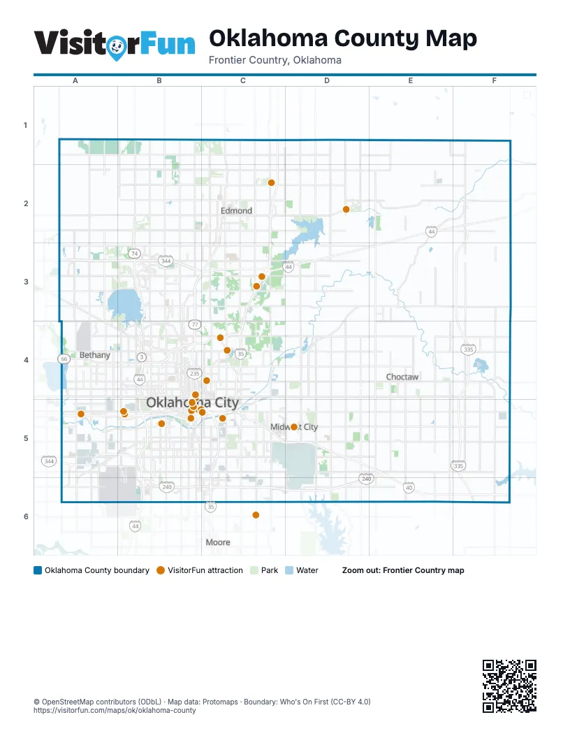
Maps inside Oklahoma County
1 map inside, from the street map of Oklahoma County down.
Street index of Oklahoma County
Each street on the sheet and the grid squares it crosses.
- North Portland AvenueB1, B2, B3, B4, B5
- South Portland AvenueB1, B5, B6
- North BroadwayC1, C2
- South Broadway StreetC1
- World War II Veterans Memorial HighwayC1, C2, C3, C4
- Danforth RoadB2
- Lake Hefner ParkwayB2, B3, B4
- North May AvenueB2, B3, B4, B5
- North Pennsylvania AvenueB2, B3, B4, B5
- North Santa Fe AvenueB2, B3, B4
- North Western AvenueB2, B3, B4, B5
- Northwest 164th StreetB2
- Northwest 178th StreetB2
- Northwest 192nd StreetB2
- South Santa Fe AvenueB2, B5, B6
- West 15th StreetB2, C2
- West Danforth RoadB2, C2
- West Edmond RoadB2, C2
- East 15th StreetC2
- East 2nd StreetC2, D2
- East 9th StreetC2
- East Danforth RoadC2, D2, E2, F2
- East Edmond RoadC2, D2
- North Boulevard StreetC2
- North Broadway StreetC2
- North Bryant AvenueC2, C4
- North Kelly AvenueC2, C3
- Shannon Miller ParkwayC2, C3
- South Boulevard StreetC2, C3
- South BroadwayC2, C3
- South Bryant AvenueC2, C5, C6
- South Kelly AvenueC2, C3
- Governor Roy Joseph Turner TurnpikeE2, F2, C3, D3, E3
- Kickapoo TurnpikeF2, F3, F4, F5, F6
- John Kilpatrick TurnpikeA3, B3, C3, A5
- North Council RoadA3, A4, A5
- North MacArthur BoulevardA3, A4, A5
- North Rockwell AvenueA3, A4, A5
- Northwest 122nd StreetA3, B3
- Northwest ExpresswayA3, B4
- West Britton RoadA3, B3
- West Hefner RoadA3, B3
- West Memorial RoadA3, B3
- Broadway ExtensionB3, C3, B4
- Clearbrook RoadB3
- East Britton RoadB3, C3
- East Hefner RoadB3
- East Memorial RoadB3, C3
- North Broadway ExtensionB3
- North Meridian AvenueB3, B4, B5
- Northeast 122nd StreetB3, C3
- Northeast 150th StreetB3, C3
- Northwest 150th StreetB3
- Quail Springs ParkwayB3
- West 33rd StreetB3, C3
- West John Kilpatrick TurnpikeB3
- East 33rd StreetC3
- North Broadway AvenueC3, B4, B5
- North Eastern AvenueC3, C4
- North I-35 Service RoadC3, C4
- North Kelley AvenueC3, C4
- North Martin AvenueA4
- North Redmond AvenueA4
- Northwest 10th StreetA4, B4
- Northwest 23rd StreetA4, B4
- Northwest 36th StreetA4, B4
- Northwest 39th ExpresswayA4, B4
- Northwest 50th StreetA4, B4, C4
- Northwest 63rd StreetA4, B4
- West Wilshire BoulevardA4, B4
- Altadena AvenueB4
- Centennial ExpresswayB4, B5, C5
- East Frontage RoadB4
- Eighty Niner DriveB4
- Gordon Cooper BoulevardB4
- North Classen BoulevardB4, B5
- North Grand BoulevardB4
- North Oklahoma AvenueB4
- North Villa AvenueB4, B5
- North Virginia AvenueB4, B5
- North Walnut AvenueB4, B5
- North Youngs BoulevardB4
- Northeast 10th StreetB4, C4, D4
- Northeast 13th StreetB4, C4
- Northeast 23rd StreetB4, C4, D4, E4, F4
- Northeast 36th StreetB4, C4, D4
- Northeast 63rd StreetB4, C4
- Northwest 13th StreetB4
- Northwest 39th StreetB4
- Northwest 40th StreetB4
- Northwest Grand BoulevardB4
- Will Rogers ExpresswayB4, C4, B5, B6
- Zach D. Taylor, Junior Memorial InterchangeB4
- Children's AvenueC4
- Honorable Hannah Diggs Atkins, Secretary of State, Memorial HighwayC4
- J W Simmons BoulevardC4, C5
- Maestro Kenneth Kilgore Memorial BridgeC4
- North Lincoln BoulevardC4, C5
- North Lottie AvenueC4, C5
- North Martin Luther King AvenueC4, C5
- North Phillips AvenueC4, C5
- North Sooner RoadC4, C5
- North Stonewall AvenueC4, C5
- Northeast 50th StreetC4
- Northeast 71st StreetC4
- Northeast Grand BoulevardC4
- Remington PlaceC4
- Representative Opio Toure Memorial HighwayC4, C5
- Stanton L Young BoulevardC4
- North Air Depot BoulevardD4, D5
- North Douglas BoulevardD4, D5
- North Midwest BoulevardD4, D5
- Church AvenueF4
- North Harrah RoadF4, F5
- Airport RoadA5, B5, A6
- Korean War Veterans Memorial HighwayA5, B5
- Regina AvenueA5, A6
- South Council RoadA5
- South MacArthur BoulevardA5
- South Rockwell AvenueA5
- Southwest 15th StreetA5, B5
- Southwest 3rd StreetA5
- Southwest 44th StreetA5, B5
- Southwest 54th StreetA5, B5
- West Reno AvenueA5, B5
- Crosstown ExpresswayB5, C5
- East Reno AvenueB5, C5, D5
- Exchange AvenueB5
- General Pershing BoulevardB5
- Harrison AvenueB5, C5
- Linwood BoulevardB5
- Linwood DiagonalB5
- North Edward King Gaylord BoulevardB5
- North Hudson AvenueB5
- North Robinson AvenueB5
- North Shartel AvenueB5
- Northeast 4th StreetB5, C5
- Northeast 5th StreetB5
- Northeast 6th StreetB5
- Northwest 4th StreetB5
- Northwest 5th StreetB5
- Northwest 6th StreetB5
- Oklahoma City BoulevardB5, C5
- Ron Norick BoulevardB5
- South Agnew AvenueB5
- South Central AvenueB5, C5
- South Classen BoulevardB5
- South Edward King Gaylord BoulevardB5
- South Hudson AvenueB5
- South May AvenueB5, B6
- South Meridian AvenueB5
- South Newcastle RoadB5
- South Pennsylvania AvenueB5, B6
- South Robinson AvenueB5
- South Shields BoulevardB5, B6, C6
- South Villa AvenueB5
- South Virginia AvenueB5
- South Walker AvenueB5, B6
- South Western AvenueB5, B6
- Southeast 15th StreetB5, C5, D5
- Southeast 25th StreetB5
- Southeast 29th StreetB5, C5, D5, F5
- Southeast 44th StreetB5, C5
- Southeast 59th StreetB5, C5, D5
- Southwest 29th StreetB5
- Southwest 4th StreetB5
- Southwest 59th StreetB5
- Southwest 5th StreetB5
- Southwest ExpresswayB5, B6
- Terminal DriveB5, B6
- Thunder DriveB5
- West I-40 Service RoadB5
- West Main StreetB5
- West Sheridan AvenueB5
- Arnold StreetC5
- Crossroads BoulevardC5, C6
- First Americans BoulevardC5
- Lincoln BoulevardC5
- Northeast 8th StreetC5
- South Eastern AvenueC5, C6
- South High AvenueC5, C6
- South I-35 Service RoadC5, C6
- South Interstate Highway 35 Service RoadC5, C6
- South Lincoln BoulevardC5
- South Martin Luther King AvenueC5
- South Prospect AvenueC5
- South Sooner RoadC5, C6
- South Sunnylane RoadC5, C6
- Tinker DiagonalC5, D5, E5, E6
- World War I Veterans Memorial HighwayC5, C6
- A AvenueD5
- Industrial BoulevardD5
- South Air Depot BoulevardD5, D6
- South Anderson RoadD5, D6
- South Douglas BoulevardD5, D6
- South Midwest BoulevardD5
- South Post RoadD5
- Southeast ExpresswayE5, B6, C6, D6, E6
- Vietnam Veteran's Memorial HighwayE5, E6, F6
- Moccasin Trail RoadF5
- South Harrah RoadF5, F6
- Southwest 74th StreetA6, B6
- East Interstate 240 Service RoadB6, C6
- Southwest 89th StreetB6
- West Interstate 240 Service RoadB6
- Helen Cole Memorial HighwayC6
- South Service RoadC6
- Southeast 66th StreetC6
- Southeast 74th StreetC6, D6
- Southeast 89th StreetC6, F6
- Newalla RoadF6
- South Newalla RoadF6
Things to do on the Oklahoma County map
- American Banjo Museum
- Bricktown
- Cattlemen's Steakhouse
- Edmond
- Experience Midwest City
- Factory Obscura
- First Americans Museum
- H&H Shooting Sports
- Myriad Botanical Gardens
- National Cowboy & Western Heritage Museum
- OKC Outlets
- Oklahoma City
- Oklahoma City National Memorial
- Oklahoma City Tourism Information Center
- Oklahoma Contemporary Arts Center
- Oklahoma History Center
- Oklahoma Native Art & Jewelry
- Oklahoma River Cruises
- Pops 66
- RIVERSPORT OKC
- Science Museum Oklahoma
- Scissortail Park
- Six Flags Frontier City
- Tener's Western Outfitters
Places on the map
- 240 Sports Complex
- Alfalfa Grove Park
- AllianceHealth Midwest
- Antler Farms
- Apple Village
- Arcadia
- Arcadia Conservation Education Area
- Arcadia Trails INTEGRIS Center for Addiction Recovery
- Arrowhead Hills
- Arrowhead Lake
- Arrowhead Trails
- Arrowhead Valley
- Aurora
- Autumn Park
- Baker Hughes
- Balon Corporation
- Bell Vern
- Bethany
- Bickham-Rudkin Park
- Blue Stem Lake
- Bluff Creek Park
- Boeking Acres
- Bouse Park
- Bricktown
- Bricktown River Walk Park
- Bridgewater
- Brock Creek
- Brock Park
- Broken Horn Ranch
- Brookside Hills
- Brown Lake
- Buell Hollis
- Camden Place
- Canyon Park
- Carle and Colcord
- Carolee Estates
- Casady School
- Cashion Place
- Cedar Ridge
- Cedar Ridge Farms I
Next to Oklahoma County
- Moore
© OpenStreetMap contributors (ODbL) · Map data: Protomaps · Boundary: Who's On First (CC-BY 4.0)