

Oklahoma map
Claremore map
About 20,602 people live here (Census Bureau, 2024 estimate). The sheet's index lists 300 streets; Will Rogers Turnpike, South Lynn Riggs Boulevard and East Will Rogers Boulevard cross the most grid squares. Things to do inside the boundary: Will Rogers Memorial Museum.
Open the map (PDF, US Letter)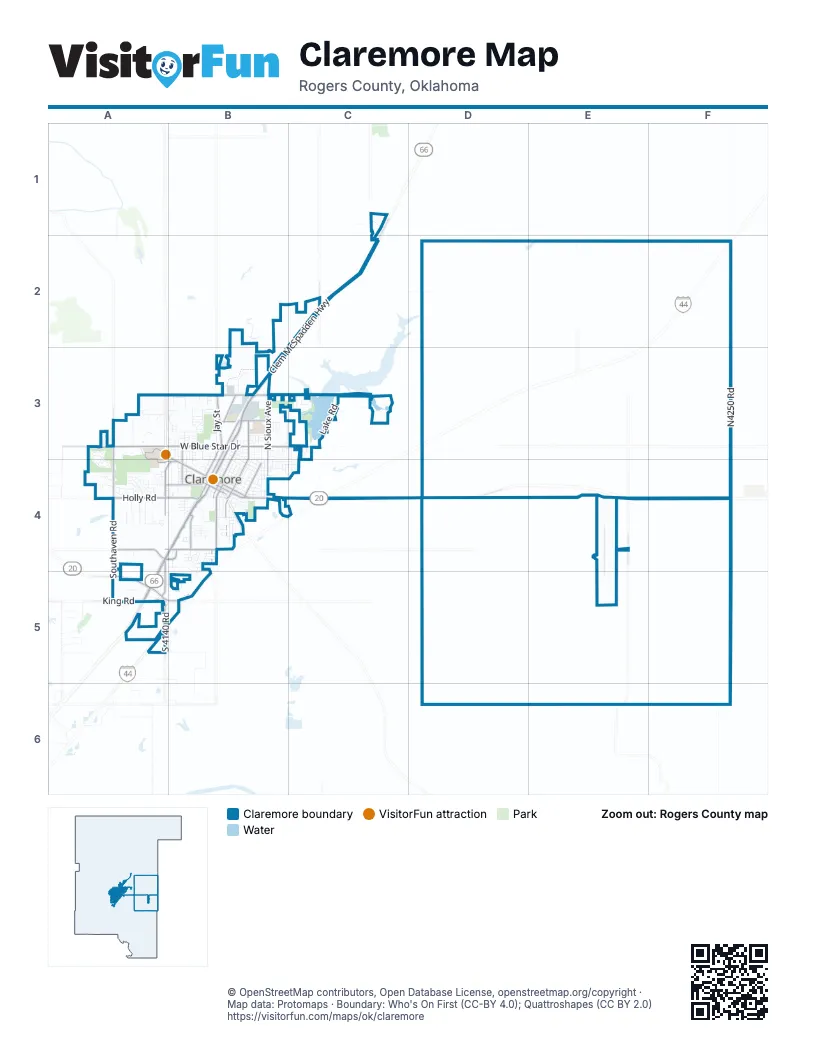
Street index of Claremore
Each street on the sheet and the grid squares it crosses.
- Will Rogers TurnpikeF2, D3, C4, A5
- Clem McSpadden HighwayC2, B3
- South Lynn Riggs BoulevardA4, B4, A5
- North Lynn Riggs BoulevardB3, B4
- East Will Rogers BoulevardB4, C4, D4
- Keetonville BypassA5
- Flint RoadA5, B5
- King RoadA5
- West Will Rogers BoulevardA3, B3, B4
- West 1st StreetB4
- East Patti Page BoulevardB4
- West Patti Page BoulevardB4
- West Blue Star DriveA3, B3
- Southaven RoadA4, A5
- North Sioux AvenueB3, B4
- West Country Club RoadA4, B4
- East Lowry RoadB3, C3
- North Florence AvenueB3, B4
- East Blue Starr DriveB3, C3
- South Muskogee AvenueB4
- North J. M. Davis BoulevardB3, B4
- Camden StreetA3, A4, B4
- South Brady StreetA4, B4
- North Industrial BoulevardB3
- Holly RoadA4
- North Clubhouse RoadA3, A4
- North Cherokee AvenueB3, B4
- Frederick RoadA4, A5
- South Florence AvenueB4
- South Reavis RoadB4
- Archer DriveA4, B4
- North Seminole AvenueB4
- West Dupont StreetA4, B4
- North Owalla AvenueB3, B4
- South 4140 RoadA5
- Northeast Harmony Star RoadE4
- South Scissortail AvenueA4, B4
- Northwest Lowery RoadB3
- Northaven RoadA3
- West Blue Starr RoadA3
- E. L. Anderson BoulevardB3
- North Reed RoadC2
- South J M Davis BoulevardB4
- South Cherokee AvenueB4
- South Davis AvenueB4
- East Stuart Roosa DriveB3
- North Davis AvenueB3, B4
- John Burrows LaneB3
- South Owalla AvenueB4
- West Stuart Roosa DriveB3
- Old Country Club RoadB4
- West Blue Starr DriveB3
- South Seminole AvenueB4
- D4168 RoadC3
- South Lake RoadC3
- South Choctaw AvenueB3, B4
- North Choctaw AvenueB3, B4
- North Dorothy AvenueB3, B4
- South Missouri AvenueB4
- Jay StreetB3
- West Raven DriveA4, B4
- North Chambers AvenueB3, B4
- North Muskogee AvenueB3, B4
- East 5th StreetB4
- East 12th StreetB3, B4, C4
- East 11th StreetB4
- North Chambers TerraceB3
- East 6th StreetB4
- North Wewoka AvenueB4
- East 10th StreetB4
- N4250 RoadF3
- North Chickasaw AvenueB3, B4
- South Moore AvenueB4
- West Ramm RoadB4
- West 6th StreetB4
- East 13th StreetB4, C4
- West 8th StreetB4
- Heritage DriveA3, A4
- College Park RoadA3
- East 9th StreetB4
- West Berwick StreetA4
- West Driftwood DriveA4
- South Chickasaw AvenueB4
- South Wortman AvenueB4
- East 4th StreetB4
- Cornerstone AvenueA3
- South Chambers AvenueB4
- West 4th Street SouthA4, B4
- North Weenonah AvenueB3, B4
- South Boling AvenueB4
- West 5th StreetB4
- North Cieda DriveB3
- West 7th StreetB4
- North Missouri AvenueB3, B4
- North Douglas DriveB3, B4, C4
- East 7th StreetB4
- West 10th StreetB3, B4
- Westwood DriveA4
- Hilltop LaneA4
- Spring LaneA4
- South Wewoka AvenueB4
- North Faulkner DriveC3, C4
- Northeast Oakridge DriveB3
- East Park StreetB4
- South Normal AvenueB4
- South Valentine LaneA4
- Winter LaneA4
- Christmas LaneA4
- West 9th StreetB3, B4
- North Kates AvenueB3, B4
- South Maywood DriveA4
- East 1st StreetB4
- Trailwood DriveA4
- Valley View DriveB3
- Southwest Wolf Run CourtB5
- South Moretz AvenueB4
- West Claremore StreetB4
- West 12th StreetB3
- West 11th StreetB3, B4
- Forest Hill DriveB3
- North Moore AvenueB3, B4
- Fairway StreetA3, A4
- South 4180 RoadC1, C2, C3
- LaviraB4
- South Maryland AvenueB4
- East Fry StreetB4
- East 17th StreetB3
- West 9th Street SouthB4
- Perdue AvenueB4
- North Oseuma AvenueB3, B4
- Pecan Park RoadB3
- North Osage AvenueB4
- North Miller DriveC3, C4
- Walnut Hill LaneB4
- Rutter RoadB3, B4
- Maplewood DriveB3
- Holly Creek RoadA3
- East 8th StreetB4
- Cowell StreetB4
- West 17th StreetB3
- Highwood DriveA4
- North Oklahoma AvenueB3, B4
- East 15th StreetB3
- North Willow DriveB3, B4
- Walnut StreetB4
- School StreetB3
- Ridgeview DriveA4
- Earthside DriveA4
- East 12th PlaceB3
- North Boling AvenueB3
- North Briscoe RoadB3
- Quail Valley DriveA3
- Southwest Elk TrailA5, B5
- West 4th Place SouthA4
- Cowell PlaceB4
- East Star StreetB3
- Valley ParkwayB3
- South Amarillo DriveB4, B5
- Pheasant DriveB5
- Pecan LaneB4
- North Wortman AvenueB3, B4
- Calloway DriveA4
- Weber RoadC3
- Maiden LaneB4
- Hillcrest RoadB4
- Heritage Hills ParkwayA4
- North Faulkner PlaceC3, C4
- Sunset DriveA4, B4
- Rogers Post RoadE4
- Memorial DriveA3
- West Danny StreetB4
- Midway RoadB4
- Falletti AvenueB3
- Parkland AvenueB3
- West Haskell StreetB4
- West Quarles StreetB4
- West Brooks StreetB4
- Strain StreetB4
- West Autumn LaneA4
- Spencer Creek RoadC1
- Ridge AvenueA3, B3
- Oklahoma PlaceB3, B4
- West 23rd Street NorthB3
- Summer LaneA4
- East Claremore StreetB4
- South Nome AvenueB4
- North Louisville AvenueB3
- West 24th Street NorthB3
- Buckingham DriveB3
- South Choctaw PlaceB4
- Harbour Town PlaceA4
- JordanB4
- South Reavis CrossingB4
- North Hickory StreetB3
- Piguet LaneA5
- South Muskogee PlaceB4
- Catalayah LaneA5
- Parkwood DriveA4
- West Cheyenne LaneB5
- West 19th Street SouthB4
- West 18th Street SouthB4
- West King LaneA5
- West 19th StreetB3
- West 13th StreetB3
- Rodeo DriveB3
- Summit DriveA3, B3
- North Wortman PlaceB3, B4
- West 20th Street SouthB4
- Club StreetA3, A4
- Lexington RoadB3
- West 21st North StreetB3
- West 22nd North StreetB3
- West Cedar StreetA4, B4
- Paradise LaneB3
- Northeast Sawyer RoadE2
- Bristol RoadB3
- South Weenonah AvenueB4
- Weenonah PlaceB3
- West Oklahoma StreetB4
- East Comet PlaceB3, C3
- Bunker StreetA3
- East 16th StreetB3
- 15th StreetB3
- South Bryanwood DriveF4
- WoodmereB3
- West Bert StreetB4
- West Eddy StreetB4
- Colhurst LaneB4
- Highwood PlaceA4
- Highland CourtA3, B3
- West 14th Street SouthB4
- Country Club RoadA4
- Rice RoadE2
- Will Rogers CourtB3
- McCloudB4
- South Falcon AvenueB4
- Dave Wilber LaneA3, A4
- East 11th Street SouthB4
- West Evergreen LaneB3
- Paradise ParkB3
- Forest Ridge ParkwayB3
- Lake RoadC3
- West 10th Street SouthB4
- Lynn Rigg BoulevardA5
- Southwest Quail Run DriveA5
- Ridge RoadA3, B3
- South PineA4
- Rosewood CourtA4
- Southeast Roden RoadD5
- West 13th Street SouthB4
- North Kansas AvenueB4
- West 9th Place SouthB4
- Kelly CourtB4
- North Meadow RoadB3
- Cornerstone LaneA3
- South 4170 RoadC4
- Oak LaneB4
- Lacrosse AvenueB4
- East 9th Street SouthB4
- McClellanB3
- Southwest Deer TrailA5, B5
- North Oak StreetB4
- Lariat LaneB3
- University DriveA3
- East Woods LaneB3
- Powell StreetB3
- Academy StreetB4
- Choctaw PlaceB4
- East 13th PlaceB3
- West Clint StreetB4
- West Prepatory StreetB3
- George StreetB4
- Ridgeview PlaceA4
- North Cherrington AvenueB3
- PayneB4
- Kates AvenueB4
- Archer CourtB4
- Autumn LaneA4
- East Quail RunC3
- North Muskogee PlaceB3
- East Comet StreetB3
- Inola StreetB4
- West 5th Street SouthA4
- Oxford LaneB3
- Woods DriveB3, C3
- Park Crest CourtB4
- West 20th StreetB3
- West Lillian StreetB4
- Northeast Easy StreetC3
- Orchid LaneB4
- E0490 RoadE4
- Fry CourtB4
- Village CourtA4
- Will Rogers PlaceB4
- Monique CircleC3
- South Anderson WayC4
- South Faith LaneB4
- Stonehaven DriveA4
- West Lake RoadC3
- Marcus DriveB4
Things to do on the Claremore map
Places on the map
- 10Box Cost-Plus
- ALDI
- Armstrong Bank
- AutoZone
- AXH Air Coolers
- Baker Hughes Business Support Services
- BancFirst
- Blue Trail - Sawtooth Loop
- Braum's
- Casey's General Store
- Central Upper Elementary School
- Chick-fil-A
- Claremont Elementary School
- Claremore Cinema 8
- Claremore Community Center
- Claremore Conference Center
- Claremore Expo Center RV Park
- Claremore Highschool
- Claremore Indian Hospital
- Claremore Lake Park
- Claremore Motor Inn
- Claremore Museum of History
- Claremore Post Office
- Claremore Recreation Center
- Claremore Regional Airport
- Claremore Soccer Fields
- Comfort Inn & Suites
- CVS Pharmacy
- Davita
- DaVita Dialysis
- Dogwood Park
- Happy Lake
- Hillcrest Hospital Claremore
- Leaning Elms Park
- Pecan Park
- Reasor's
- Rogers State University Nature Reserve
- Walmart Supercenter
- Will Rogers Park
- Woodlawn Cemetery
© OpenStreetMap contributors, Open Database License, openstreetmap.org/copyright · Map data: Protomaps · Boundary: Who's On First (CC-BY 4.0); Quattroshapes (CC BY 2.0)















