

Oklahoma map
Rogers County map
About 101,371 people live here (Census Bureau, 2024 estimate). The sheet's index lists 300 streets; Will Rogers Turnpike, South 4190 Road and South 4210 Road cross the most grid squares. Things to do inside the boundary: Blue Whale of Catoosa, Claremore and Hard Rock Hotel & Casino Tulsa.
Open the map (PDF, US Letter)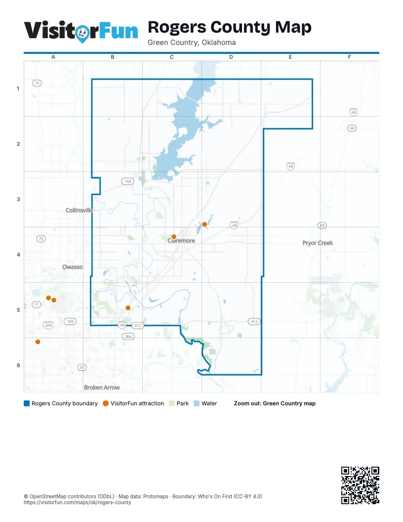
Street index of Rogers County
Each street on the sheet and the grid squares it crosses.
- Will Rogers TurnpikeD3, E3, C4, D4, B5, C5
- Dan P. Holmes Memorial ExpresswayB5, C5, D5, E5
- Admiral Joe "Jocko" Clark TrailwaysE1, D2, E2
- Clem McSpadden HighwayD2, C3, D3, C4
- South Lynn Riggs BoulevardC4
- East 420 RoadB3, C3, D3
- Keetonville BypassB4, C4
- Northeast Sawyer RoadD2, D3
- East Will Rogers BoulevardC4, D4
- East 116th Street NorthB4
- North Lynn Riggs BoulevardC4
- Spencer Creek RoadD2, E2, D3
- Pearl Harbor Memorial ExpresswayB3
- North 289th East AvenueC5
- King RoadC4
- Walnut StreetE1, E2, C4
- South Elm StreetE1, B2, B3, C3
- North Elm StreetB2, B3
- Andy Payne BoulevardD2, D3
- Flint RoadC4
- Elm StreetC1, C2, C3, C4
- Yonkipin DriveB5
- East Layton StreetE1
- Southwest Flint RoadC4
- East Denbo StreetB5
- Lynn Riggs BoulevardC4
- East 46th Street NorthB5
- North 193rd East AvenueB3, B4, B5
- 6th StreetD2, E2
- South Cherokee StreetD3, B5
- West 6th StreetD1, E1, C4
- West Will Rogers BoulevardC4
- North 193rd Avenue EastB5
- North Broadway AvenueD5
- Vine StreetE1, E2
- West 1st StreetC4
- Antry DriveB5
- East Patti Page BoulevardC4
- West Patti Page BoulevardC4
- South 4200 RoadD1, D2, D3, D4, D6
- South 4190 RoadD1, D2, D3, D4, D5, D6
- East 300 RoadD1, E1
- East 430 RoadB3, C3, D3, E3
- South 4110 RoadC1, C2, C3
- North 177th East AvenueB4, B5
- Northeast Harmony Star RoadD3, D4, D5
- South 4080 RoadB1, B2, B3, B4
- East 390 RoadB2, C2, D2
- East Pine Street NorthB5, C5
- North Owalla RoadC2, C3
- North 161st East AvenueB3, B4, B5
- North Reed RoadC2, C3
- Northaven RoadC3, C4
- Northeast Spencer Creek RoadD2, D3
- East 400 RoadC2, D2
- South Keetonville RoadB4
- East 600 RoadC5, D5
- East 106th Street NorthB4
- South 4220 RoadD1, D2, D3, D6
- East 126th Street NorthB4, D4
- E0300 RoadB1, E1
- North 209th East AvenueB4, B5
- East 540 RoadC5, D5
- Northeast Crusher RoadC3, D3
- East Admiral PlaceB5, C5
- East 86th Street NorthB4
- East 96th Street NorthB4
- Southeast Flint RoadC4, D4
- East Country Club RoadC4, D4
- East 76th Street NorthB4
- South 4050 RoadB2, B3
- South 4140 RoadC2, C3, C4
- Main ParkwayB5
- West Blue Star DriveC4
- North 149th East AvenueB3, B4, B5
- West Blue Starr RoadC4
- Southwest Fisher RoadC4
- Tiger Switch RoadB5
- West Tigerswitch RoadB5
- Southaven RoadC4
- North Sioux AvenueC3, C4
- East Winganon RoadC1, D1
- Arkansas RoadB4, B5
- West Country Club RoadC4
- D4080 RoadB2
- Evans RoadB5
- East Lowry RoadC4
- Old Highway 33D5
- South Elm RoadB3, B4
- East 500 RoadB4, C4, D4
- North Florence AvenueC4
- East 146th Street NorthB3
- East Blue Starr DriveC4
- East Skelly Drive SouthB5
- South Muskogee AvenueC4
- Keystone AvenueB5
- North J. M. Davis BoulevardC4
- South 4215 RoadD1, D5
- Camden StreetC4
- South Brady StreetC4
- Franklin RoadC5
- North Industrial BoulevardC4
- Holly RoadC4
- North Clubhouse RoadC4
- Northwest Lowery RoadC4
- Southwest BoulevardD5
- North Cherokee AvenueC4
- East 66th Street NorthB4
- West Rollins StreetB5
- Frederick RoadC4
- South Florence AvenueC4
- South Reavis RoadC4
- Archer DriveC4
- South Broadway AvenueD5
- North Seminole AvenueC4
- West Dupont StreetC4
- North Owalla AvenueC4
- North Cherokee StreetB5
- South Scissortail AvenueC4
- East Rice StreetB5
- E. L. Anderson BoulevardC4
- Gordon RoadC4
- East Commercial StreetD5
- Old US Highway 169B3
- North 145th Avenue EastB3, B4, B5
- South J M Davis BoulevardC4
- South Cherokee AvenueC4
- Ranch RoadB3, B4
- North 165th Avenue EastB5
- West Commercial StreetD5
- South Davis AvenueC4
- North Shawnee StreetB5
- North 193rd BywayB4, B5
- East Stuart Roosa DriveC4
- North Boundary RoadB2
- North Davis AvenueC4
- West 3rd StreetE1, B5
- North 145th East AvenueB4, B5
- Owalla RoadC3, C4
- Double R RoadB5
- John Burrows LaneC4
- Robson RoadB5
- West Denbo StreetB5
- Haynes RoadB5
- East Ford StreetB5
- Old Highway 169B3
- South Owalla AvenueC4
- South 305th East AvenueC5
- E0480 RoadE4
- South 273rd Avenue EastC5
- West Stuart Roosa DriveC4
- Old Country Club RoadC4
- Crusher RoadD3
- West Blue Starr DriveC4
- North 145 EastB4
- South Seminole AvenueC4
- South 4210 RoadD1, D2, D3, D4, D5, D6
- South 4180 RoadD1, D2, D3, D4, D5
- East 590 RoadC5, D5, E5
- South 4170 RoadC1, C2, C3, C4, C5, C6
- East 330 RoadD1, E1
- East 380 RoadB2, C2, D2
- South 4250 RoadE4, E5, E6
- East 440 RoadC3, D3, E3
- East 610 RoadD6, E6
- East 340 RoadD2, E2
- East 570 RoadC5, D5, E5
- East 620 RoadD6, E6
- East 450 RoadC3, D3
- South 4090 RoadB1, B2, B3, B4, B5
- East 640 RoadD6, E6
- South 4130 RoadC1, C2, C3
- N4250 RoadE2, E3, E4
- East 310 RoadB1, C1, D1, E1
- East 550 RoadB5, C5, D5
- East 560 RoadC5, D5, E5
- E0290 RoadB1, C1, D1, E1
- Washington RoadD3
- Redbud DriveB5
- South 4120 RoadC2, C3, C4, C5
- South 4240 RoadD3, D4, D6
- East 650 RoadD6, E6
- East 530 RoadC4, D4
- North 154th East AvenueB3, B4, B5
- South 4100 RoadB2, B3
- South 4260 RoadE1, E2
- North Briscoe RoadC3
- East 320 RoadB1, D1, E1
- East 460 RoadB3, C3, D3
- South 4270 RoadE1
- East 350 RoadB2, D2, E2
- CR S4100B1
- South 4160 RoadC2, C5
- Comaran LaneC4, C5, D5
- South 4235 RoadD1, D2, D3
- East Apache StreetC5
- East 470 RoadB3, B4, D4
- North 155th East AvenueB3, B4, B5
- Northeast Blue Creek RoadC2, D2
- Apache StreetB5, C5
- South 4150 RoadC2
- East 580 RoadD5, E5
- East 370 RoadB2
- North 152nd East AvenueB3, B4
- North 150th East AvenueB3, B4
- Northeast Morgan RoadC3, D3
- East 112th Street NorthB4
- South 4230 RoadD1, D2, D3
- East 480 RoadC4, D4
- E0350 RoadC2, D2
- East 121st Street NorthB4
- South 4185 RoadD2, D3
- South 4060 RoadB2
- North 147th East AvenueB4, B5
- Gregory School RoadC5
- Pine AvenueD2, D3
- Hughes RoadC4, D4
- North 170th East AvenueB4, B5
- South 4075 RoadB2, B3
- Northeast Akin RoadC3, D3
- South Lake RoadD3, C4, D4
- North 165th East AvenueB4, B5
- East 1st StreetE1, C4
- East 72nd Street NorthB4
- North 163rd East AvenueB4, B5
- North 157th East AvenueB4, B5
- Bird Creek AvenueB4, B5
- East Lowery RoadC4
- East 108th Street NorthB4
- East 79th Street NorthB4
- E0360 RoadC2, D2
- East Caney River RoadB3
- E0430 RoadC3, D3
- North 151st East AvenueB3, B4
- South 4275 RoadE1, E2
- East 520 RoadC4, D4
- North 167th East AvenueB4, B5
- Northeast Ward RoadD3
- N4300 RoadE1, E2
- East 335 RoadB1, D1, E1
- Skyline DriveB4
- Bernie RoadC3, D3
- Clear Brook RoadB4
- Crane RoadD5
- East 110th Street NorthB4
- East 120th Street NorthB4
- Todd Ranch RoadC1
- East 360 RoadC2
- Goose Island RoadC2
- East 92nd Street NorthB4
- East 176th Street NorthB3, B4
- East 630 RoadD6, E6
- Valley AvenueB4
- East 118th Street NorthB4
- East 6th StreetE1, E2, C4
- North Ranch RoadB3
- Northeast Robson RoadC3
- East Marshall Street NorthB5
- S Ranch RoadB3
- Ridge RoadB4, C4, B5
- East 91st Street NorthB4
- East 82nd Street NorthB4
- D4168 RoadC4
- Lone Elm RoadC4
- East 78th Street NorthB4
- East Archer StreetB5, C5
- East 99th Street NorthB4
- East 415 RoadC3, D3
- East 94th Street NorthB4
- North 153rd East AvenueB3, B4
- Northeast Bernie RoadD3
- Alton RoadC4
- North 156th East AvenueB4, B5
- North Lone Elm RoadC4
- South Maple AvenueD2, D3
- Big Sky LaneB2
- East 80th Street NorthB4
- E0385 RoadC2, D2
- North 146th East AvenueB4
- North 225th East AvenueB5
- Southeast Swan RoadD4
- East 111th Street NorthB4
- East Virgin StreetB5, C5
- North 160th East AvenueB4, B5
- South Choctaw AvenueC4
- South Red Bud DriveB5
- East 89th Street NorthB4
- Justus RoadD4
- North 148th East AvenueB3, B4
- North Choctaw AvenueC4
- West 8th StreetE1, C4
- East 5th StreetE1, C4
- South 4102 RoadC3
- West 10th StreetE1, E2, C4
- Southeast Roden RoadD4
- East Marshall RoadB4
- Skiatook RoadB5
- South 4205 RoadD2, D4, D5
- West 7th StreetE1, C4
- North Dorothy AvenueC4
Things to do on the Rogers County map
Places on the map
- Big Lake
- Blue Trail - Sawtooth Loop
- Boulder Point
- Bushyhead
- Canyon Lake
- Catoosa
- Catoosa Hills Shopping Center
- Centennial Park
- Centennial Park Part 2
- Chelsea
- Cherokee Hills Golf Club
- Claremore
- Claremore Highschool
- Claremore Lake Park
- Fair Oaks
- Foyil
- Gregory
- Inola
- Justice
- Lake Claremore
- Limestone
- Oknoname 131004 Reservoir
- Oknoname 131010 Reservoir
- Oknoname 131012
- Oknoname 131016 Reservoir
- Oologah
- Oologah Lake
- Oologah School
- P S O Lake
- Pecan Park
- Petersons Lake
- Redbud Valley
- Reservoir 131008
- Sequoyah
- Talala
- The Patriot Golf Club
- Tiawah
- Tulsa Port of Catoosa
- Valley Park
- Verdigris
Next to Rogers County
- Broken Arrow map
- Collinsville
- Owasso
- Pryor Creek
© OpenStreetMap contributors, Open Database License, openstreetmap.org/copyright · Map data: Protomaps · Boundary: Who's On First (CC-BY 4.0); Quattroshapes (CC BY 2.0)