

Oklahoma map
Comanche County map
About 121,396 people live here (Census Bureau, 2024 estimate). The sheet's index lists 300 streets; Lake Road, Harry E. Bailey Turnpike and E1490 Road cross the most grid squares. Things to do inside the boundary: Comanche Nation Casino, Comanche Spur Casino and Lawton.
Open the map (PDF, US Letter)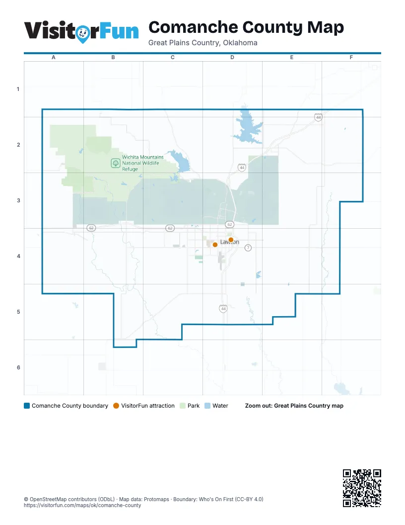
Maps inside Comanche County
1 map inside, from the street map of Comanche County down.
Street index of Comanche County
Each street on the sheet and the grid squares it crosses.
- Harry E. Bailey TurnpikeE1, F1, D2, E2, D3, D5
- Pioneer ExpresswayD3, D4, D5
- Bill W. Burgess, Junior HighwayD3, D4
- Southwest Lee BoulevardB4, C4, D4
- Northwest Rogers LaneA3, B3, C3, D3
- West Gore BoulevardB4, C4, D4
- Northwest Cache RoadB4, C4, D4
- Southeast Lee BoulevardD4, E4
- East Gore BoulevardD4, E4, F4
- Southwest 11th StreetD4, D5
- Southwest Sheridan RoadD4, D5
- Northwest Sheridan RoadD3, D4
- Northwest Fort Sill BoulevardD3, D4
- Northwest Quanhah Parker Trail WayC4, D4
- Northeast Rogers LaneD3, E3, F3
- 1st StreetD2, E2, B6
- Northwest Quanah Parker TrailwayC4
- 8th StreetE2
- West DriveE2
- Northwest 2nd StreetD4
- Sharps LaneD4
- Southwest Gore BoulevardD4
- Lake RoadB2, C2, D2, E2, D3, E3, F3
- Baseline RoadB4, A5, B5, C5, E5
- Base Line RoadA5, B5, E5
- Southwest 82nd StreetC4, C5
- Southeast Flower Mound RoadD4, D5
- Southeast 45th StreetD4, D5
- Southwest 38th StreetD4, D5
- Edna Hennessee Memorial HighwayC2, C3
- 165th StreetE3, E4
- Southwest 6th StreetD4
- Cache-Meers RoadC2, C3
- Northwest Ferris AvenueC4, D4
- Sheridan RoadD3
- Southwest F AvenueD4
- Southeast 150th StreetE3, E4
- Southwest C AvenueD4
- Main StreetF2, A4, D4, D5
- Northeast Flower Mound RoadD3, D4
- Northwest 38th StreetD3, D4
- Northwest 82nd StreetC3, C4
- 3rd StreetE2, B5
- Southwest 2nd StreetD4
- Northwest County Highway 115B4
- Southwest County Highway 115B4
- Southwest Baseline RoadC5, D5
- Southwest 1st StreetD4
- South 8th StreetB3, B4
- North 8th StreetB3
- 5th AvenueF2
- East Main StreetF2
- James StreetF2
- Indiahoma RoadA3, B3, A4, A5
- Northeast Cache RoadD4, E4, F4
- Northeast North DriveD2, E2, F2
- Southwest Bishop RoadC4, D4
- Old US Highway 62A4, B4
- Southwest 67th StreetC4, C5
- South Railroad StreetD4, D5
- N2430 RoadB5, B6
- County Highway 115B4, B5
- Northeast Tony Creek RoadE1, E2
- Southwest 52nd StreetC4, D4, D5
- Northwest Indiahoma RoadB2, A3, B3
- Northeast Keeney RoadE2, E3
- Whitfield RoadF1, F2
- Apache Gate RoadD3
- Deyo Mission RoadC3, C4
- H AvenueB4
- Northeast 180th StreetF2, F3
- Southwest B AvenueD4
- Currie RoadD3
- Mow-Way RoadD3
- Northwest 67th StreetC3, C4
- Southwest East AvenueD4
- Southwest D AvenueD4
- Northeast Wild Horse RoadD3
- Southwest Goodyear BoulevardC4
- Northeast 45th StreetD3, D4
- Southwest 17th StreetD4
- Mowway RoadD3
- Southwest J AvenueD4
- Indian Trail RoadD3, D4
- Southwest 5th StreetD4
- Industrial Loop RoadE2
- Wheatland AvenueA4
- Post RoadD3
- Northwest 52nd StreetD3, D4
- A StreetE2
- Northwest 53rd StreetC4
- Southwest 27th StreetD4
- Northwest Goodyear BoulevardC4
- Thomas StreetD3
- Southwest Tennessee AvenueD4
- Bateman RoadD3
- Cache Road NorthwestB4
- Northwest 5th StreetD3, D4
- West North DriveE2
- Showplace BoulevardA4
- North Railroad StreetD4
- East North DriveE2
- East H AvenueB4
- FirebreakD2, E2, D3, E3
- South Boundary RoadA3, B3, C3, D3, E3
- Southwest Coombs RoadB4, C4, D4
- Southeast Bishop RoadD4, E4, F4
- E1760 RoadB5, C5, D5, E5
- E1490 RoadA1, B1, C1, D1, E1, F1
- Southwest Tinney RoadB5, C5, D5
- Southeast Coombs RoadD4, E4, F4
- Southeast Woodlawn RoadD4, E4, F4
- E1740 RoadB5, C5, D5, E5
- E1770 RoadB5, C5, D5, E5
- E1750 RoadB5, C5, D5, E5
- New Hope RoadC2, C5, D5
- Northeast Trail RoadE2, E3
- East Boundary RoadE2, E3
- Southeast Goodin RoadD4, E4
- South Boundary AccessA3, B3
- N2330 RoadA3, A4, A5
- County Line RoadF3, F4
- Southwest Woodlawn DriveC4, D4
- N2380 RoadA3, B3
- King RoadE1, F1, E2, D3, D4
- Blue Beaver Valley RoadB3, C3
- Spencer RoadE3, F3
- Meers-Porter Hill RoadC2, D2
- Northwest 277th StreetA2, A3
- Elgin RoadD2, E2, D3
- Southeast 60th StreetE4, E5
- Southeast 135th StreetE4, E5
- Trail RoadE4, E5
- Southeast Tinney RoadD5, E5, F5
- Northeast 120th StreetE1, E2, E3, E4
- McKenzie Hill RoadB3, C3
- Townley RoadE3, F3
- Miller RoadC2, D2, E2
- Southeast Baseline RoadD5, E5
- N2750 RoadF2, F3
- Firebreak 41D2, E2, D3
- N2730 RoadF2, F3
- Southeast 165th StreetE4, E5
- N2740 RoadF2, F3
- Northwest 267th StreetA2, A3
- Bethel RoadF3, F4, F5
- Southwest Pecan RoadB4, C4
- E1610 RoadA3, B3, F3
- Bald Ridge RoadD3, E3
- Tinney RoadE5, F5
- N2440 RoadB5, B6
- Post Oak RoadA3
- Watts RoadE2, F2
- North Boundary RoadC3, D3
- N2450 RoadB5, B6
- E1780 RoadB5, C5
- N2490 RoadC5
- Rieck RoadE2
- Southeast 120th StreetE4, E5
- Beef Creek RoadD3
- E1790 RoadB6, C6
- Southwest Crater Creek RoadB4, B5
- Southeast Bethel RoadF3, F4
- 90th StreetE4, E5
- N2480 RoadC5
- Deer Creek Canyon RoadC3
- Southwest 97th StreetC4
- N2470 RoadC5
- Northeast Watts RoadD2, E2, F2
- N2460 RoadC5
- N2500 RoadC5
- N2420 RoadB5
- Tower Two RoadD3
- Cline RoadE2, F2
- Tank TrailD3
- Southeast 90th StreetE4, E5
- Southwest 112th StreetC4, C5
- 112th StreetC4
- Southwest Post Oak RoadB4
- Northeast 135th StreetE3, E4
- E1550 RoadF2
- Southwest Pecan DriveC4, D4
- Logue Chapel RoadC5
- Carlson RoadE3, F3
- Jimmy Quoetone RoadC2
- Dunn RoadD2
- N2610 RoadD5
- Tackle Box RoadC2, D2
- 75th StreetC4, E4, E5
- N2530 RoadC5
- Frisco Ridge LoopD2
- N2580 RoadD5
- N2540 RoadD5
- Devine RoadD5
- FB70D3, E3
- Rogers LaneC2, C3, E3, B4
- Punch Bowl RoadD3
- FB48D3, E3
- Northwest Columbia AvenueC4, D4
- Southwest Airport RoadB4, C5
- E1540 RoadF2
- Southeast Pecan DriveD4, E4, F4
- Shroyer RoadC2
- Mountain View DriveB3, E3
- Randolph RoadD3
- Northwest Euclid AvenueC4, D4
- N2630 RoadE5
- Back Access RoadD3
- Old Post Oak RoadB4, B5
- 4 Mile RoadC2, D2, D3
- Southeast 15th StreetD4, D5
- Southwest Quanah RoadB4
- 3203 Southeast 75th StreetE4
- Hurst RoadC5
- Northwest Carlson RoadA3
- Beech RoadE5, F5
- Glover RoadC2, D2
- Southwest G AvenueD4
- Southeast 210th StreetF4, F5
- Mc Kenzie Hill RoadC3, D3
- Northwest 257th StreetA3
- Northwest Bell AvenueD4
- Edgewater BoulevardD2
- Southwest 127th StreetC4, C5
- Northwest Dearborn AvenueC4, D4
- Southwest Paint RoadC4, C5
- East Lake DriveC2, C3
- Northwest Lincoln AvenueC3, D3, C4, D4
- Northwest Arlington AvenueD4
- N2650 RoadE1, E5
- FB58D3, E3
- Northwest Paint RoadC4
- Sycamore StreetE1, E2
- Northeast 225th StreetF1, F2
- Southwest H AvenueD4
- N2560 RoadD1, D5
- Mountain View RoadE3, F3
- Southwest I AvenueD4
- E1750 New HopeD5, E5
- Northwest Williams AvenueC3, D3
- Northwest Madische RoadD2, D3
- FB67E3
- Southwest A AvenueD4
- Southwest Woodlawn RoadB4, C4
- N2620 RoadE5
- East Cache Creek RoadD3
- Southwest Jefferson AvenueD4
- Firebreak 39D3
- Northwest Lindy AvenueD3
- Northeast Lawrie Tatum RoadD3, D4
- E1800 RoadB6
- Northwest Townley RoadA3
- Northeast 150th StreetE1, E3
- Northwest Ozmun AvenueD3
- Northwest 40th StreetD3, D4
- 127th StreetC4
- brown Hill RoadC3
- Dodge Hill RoadD3
- Rocky Twins RoadC3, D3
- Stoney Point RoadD2, D3
- Northwest Oak AvenueC4, D4
- Old Starr RoadB3
- Mount Hinds RoadC3, D3
- Stony Point RoadD2
- Northeast Carlson RoadE3, F3
- E1600 RoadF3
- Burrill RoadD3
- 180th RoadF3
- E1570 RoadF2
- Southwest Red Elk RoadC4
- Chibitty RoadC2
- Brush Canyon RoadC3
- N2720 RoadF2, F3
- N2510 RoadC5
- N2520 RoadC5
- North Trail RoadE3, E4
- Wolf RoadC2
- Woodlawn RoadE4
- McClung RoadC2
- Northwest Post Oak RoadB3, B4
- Northwest Quanah RoadB3, B4
- Southwest Park AvenueC4, D4
- Chatto RoadD3
- Northwest Taylor AvenueC4, D4
- Quinette RoadD3
- Southwest Summit AvenueC4, D4
- Northwest 17th StreetD3, D4
- Northwest 16th StreetD3, D4
- Northeast Kleeman RoadE1, E2
- Southwest Washington AvenueD4
- Ketch RoadC3
- Northeast 75th StreetE2, E4
- Northwest Cherry AvenueB3, C4, D4
- Medicine Creek DriveB2
- Snow Ridge RoadD3
- Southwest Douglas AvenueD4
- Southwest 16th StreetD4
- Southwest 15th StreetD4
- Northwest 197th StreetB3, B4
- Northwest Elm AvenueC4, D4
Things to do on the Comanche County map
Places on the map
- Crater Lake Demolition Area
- Dudded Impact Area
- Dudder Impact Area
- Fort Sill
- Fort Sill Main Post
- Henry Post Army Airfield
- North Arbuckle - Live Fire Area
- Quanah Range - Live Fire Area
- SEC
- South Arbuckle - Live Fire Area
- West Range - Live Fire Area
- Wichita Mountains National Wildlife Refuge
© OpenStreetMap contributors, Open Database License, openstreetmap.org/copyright · Map data: Protomaps · Boundary: Who's On First (CC-BY 4.0); Quattroshapes (CC BY 2.0)















