

Oklahoma map
Lawton map
About 90,027 people live here (Census Bureau, 2024 estimate). The sheet's index lists 300 streets; Pioneer Expressway, Bill W. Burgess, Junior Highway and Southwest Lee Boulevard cross the most grid squares. Things to do inside the boundary: Comanche Nation Casino and Museum of the Great Plains.
Open the map (PDF, US Letter)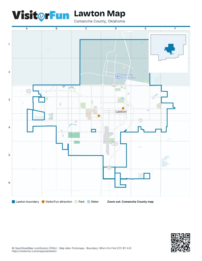
Street index of Lawton
Each street on the sheet and the grid squares it crosses.
- Pioneer ExpresswayD1, D2, D4, E4, D5, D6
- Bill W. Burgess, Junior HighwayD2, D3, E3, E4
- Southwest Lee BoulevardA4, B4, C4, D4
- Northwest Rogers LaneA2, B2, C2, D2
- Northwest Cache RoadA3, B3, C3, D3
- West Gore BoulevardB3, C3, D3
- Southwest Sheridan RoadD3, D4, D5, D6
- Southeast Lee BoulevardD4, E4, F4
- Southwest 11th StreetD3, D4, D5, D6
- Northwest Sheridan RoadD2, D3
- Northwest Fort Sill BoulevardD1, D2, D3
- East Gore BoulevardD3, E3, F3
- Northwest Quanhah Parker Trail WayB3, C3
- Northeast Rogers LaneD2, E2
- Northwest Quanah Parker TrailwayB3
- Northwest 2nd StreetD3
- Sharps LaneE4
- Southwest Gore BoulevardD3
- Southwest 6th StreetD3, D4, D5
- Southwest 38th StreetC3, C4, C5
- Northwest Ferris AvenueB3, C3, D3
- Sheridan RoadD2, E2
- Southwest 82nd StreetB3, B4
- Southwest F AvenueC4, D4
- Southeast Flower Mound RoadE3, E4, E6
- Southwest C AvenueC3, D3
- Northeast Flower Mound RoadE2, E3
- Northwest 38th StreetC2, C3
- Northwest 82nd StreetB2, B3
- Southeast 45th StreetF3, F4
- Southwest 2nd StreetD3, D4
- Southwest 1st StreetD3, D4
- Southwest Bishop RoadA4, B4, C4, D4
- South Railroad StreetD3, D4, D5, D6
- Southwest 67th StreetB3, B4, B5
- Southwest 52nd StreetC3, C4, C5
- Northeast Cache RoadE3, F3
- Southwest B AvenueC3, D3
- Currie RoadD1, D2
- Mow-Way RoadC2, D2
- Northwest 67th StreetB2, B3
- Southwest East AvenueC3, D3
- Southwest D AvenueC3, D3
- Southwest Goodyear BoulevardB3, B4
- Northeast 45th StreetF2, F3
- Southwest 17th StreetD3, D4
- Southwest J AvenueC4, D4
- Apache Gate RoadD1
- Indian Trail RoadD2, D3
- Southwest 5th StreetD3, D4
- Post RoadD2
- Northwest 52nd StreetC2, C3
- Mowway RoadC2
- Northwest 53rd StreetC3
- Southwest 27th StreetC3, C4
- Northwest Goodyear BoulevardB3
- Thomas StreetD2
- Bateman RoadD1
- Southwest Tennessee AvenueC4, D4
- Northwest 5th StreetD3
- North Railroad StreetD3
- Southwest Coombs RoadB5, C5, D5
- Tank TrailC1, D1, C2
- South Boundary RoadC2, D2, E2
- Northwest Columbia AvenueB3, C3, D3
- Southwest Woodlawn DriveB5, C5, D5
- Randolph RoadC1, D1, D2
- Northwest Euclid AvenueB3, C3, D3
- Back Access RoadD1, D2
- Southeast Bishop RoadD4, E4, F4
- Southwest G AvenueC4, D4
- Tower Two RoadC1, C2
- Northwest Bell AvenueC3, D3
- Northwest Dearborn AvenueC3, D3
- Northwest Lincoln AvenueC3, D3
- Northwest Arlington AvenueC3, D3
- Southwest H AvenueC4, D4
- Southwest I AvenueC4, D4
- Northwest Williams AvenueC3, D3
- Southwest A AvenueC3, D3
- East Cache Creek RoadE2
- Southwest Jefferson AvenueC4, D4
- Southeast Tinney RoadD6, E6
- Northwest Lindy AvenueC2, C3, D3
- Northeast Lawrie Tatum RoadD2, D3, E3
- Northwest Ozmun AvenueC2, D2, C3
- Northwest 40th StreetC2, C3
- Northwest Oak AvenueB3, C3, D3
- Burrill RoadC2, D2
- Southwest Park AvenueB4, C4, D4
- Chatto RoadD1
- Northwest Taylor AvenueB3, D3
- Quinette RoadD1, E1, D2
- Southwest Summit AvenueB4, C4, D4
- Northwest 17th StreetD2, D3
- Northwest 16th StreetD2, D3
- Southwest Washington AvenueC4, D4
- Southwest Douglas AvenueD4
- Southwest 16th StreetD3, D4
- Southwest 15th StreetD3, D4
- Beef Creek RoadE1, E2
- Northwest Elm AvenueB3, C3, D3
- Northwest Andrews AvenueB3, C3, D3
- Southwest 14th StreetD3, D4
- Northwest Cherry AvenueB3, C3, D3
- Northwest Ash AvenueB3, C3, D3
- Howitzer TrailD2, E2
- Bald Ridge RoadE1, E2
- Southwest Monroe AvenueD4
- Southwest 45th StreetC3, C4
- King RoadD1, D4
- Geronimo RoadD1, D2
- Southwest 12th StreetD3, D4
- Southwest Garfield AvenueD4
- Northwest Baldwin AvenueB3, D3
- Southwest 4th StreetD3, D4
- Southwest 13th StreetD3, D4
- Macomb RoadD1, D2
- Southwest 8th StreetD3, D4
- Southwest 10th StreetD3, D4
- Red Cloud RoadE1, E2
- Condon RoadD1, D2
- Northwest 14th StreetD2, D3
- Northwest Hoover AvenueC3, D3
- Northwest Pollard AvenueC3, D3
- Northwest 18th StreetD2, D3
- Northwest 19th StreetD2, D3
- Northwest 34th StreetC2, C3
- Northwest Cheyenne AvenueB3, C3, D3
- Southwest 9th StreetD3, D4
- Northwest Smith AvenueC3, D3
- Northwest 13th StreetD3
- Northwest Kingsbury AvenueB3, D3
- Northwest 31st StreetC3
- Southwest 7th StreetD3, D4
- Northwest 20th StreetD2, D3
- Northwest 24th StreetC2, C3, D3
- Northwest 36th StreetC3
- Southeast Pecan DriveD5
- Northwest Lawton AvenueB3, D3
- Northwest 15th StreetD3
- Northwest Denver AvenueB3, C3, D3
- Northwest Liberty AvenueC3, D3
- Northwest 35th StreetC3
- Northwest 12th StreetD3
- Southwest 3rd StreetD3, D4
- Corral RoadD2, E2
- Southwest Roosevelt AvenueD4
- 112th StreetA4
- Southwest Tinney RoadD6
- Northwest Atlanta AvenueB3, C3, D3
- Northwest Compass DriveB3, C3
- Southwest McKinley AvenueD4
- Upton RoadD1
- Northwest Irwin AvenueB3, D3
- Artillery Ridge RoadC1
- Northwest 32nd StreetC3
- Northwest 75th StreetB2, B3
- Knob Hill RoadD1
- Southwest 68th StreetB3, B4
- Northwest Maple AvenueB3, C3, D3
- Punch Bowl RoadD1
- Northeast Kingsbriar DriveE3
- Northwest Kinyon AvenueC3, D3
- Northeast 15th StreetE3
- Northwest Lake AvenueC3, D3
- Northwest 22nd StreetC2, C3, D3
- Northwest 50th StreetC3
- Snow RoadD2
- Northwest Baltimore AvenueC3, D3
- Southwest 24th StreetC3, D3, C4, D4
- Southwest Texas AvenueC4, D4
- Southwest Beta AvenueB3, C3
- Northwest 47th StreetC3
- Northwest Meadow Brook DriveC3
- Craig RoadD1, D2
- Cubbison RoadC2
- Northwest Eisenhower DriveB3, C3
- Honeycutt RoadD2
- Northwest Taft AvenueD3
- Northwest 26th StreetC2, C3
- Southeast 1st StreetD4
- Berry StreetD2, E2
- Southwest 19th StreetD3, D4
- Southwest 20th StreetD3, D4
- Southwest 21st StreetD3, D4
- Southeast Camelot DriveE3, F3, E4
- Southwest 18th StreetD3, D4
- Boundary RoadD2, E2
- Curie RoadD2
- Northwest 3rd StreetD3
- Rothwell StreetD2, E2
- Southwest Cherokee AvenueB3, C3, C4
- Northwest 23rd StreetC2, C3, D3
- Southwest 69th StreetB3, B4
- Northwest 44th StreetC3
- Southeast Tower RoadE4
- Northeast Bell AvenueD3, E3, F3
- Southwest 26th StreetC3, C4
- Northwest Santa Fe AvenueC3
- Northwest 76th StreetB3
- Northwest 49th StreetC2, C3
- Northwest 7th StreetD3
- Northwest 43rd StreetC3
- Northwest Floyd AvenueC3, D3
- Southwest New York AvenueC4, D4
- Northwest 72nd StreetB3
- Northwest 46th StreetC2, C3
- Rucker RoadD1
- Southwest Wolf StreetC4, D4
- Spalding AvenueD2
- Southwest Boyles Landing RoadC4
- Southwest 25th StreetC3, C4
- Southwest 49th StreetC3, C4
- Cannoneer Field RoadC2, D2
- Northwest 27th StreetC3
- Northwest 57th StreetC3
- Northwest 25th StreetC3
- Northwest Micklegate BoulevardB3
- Southeast Interstate DriveE3, E4
- Northeast 25th StreetE3
- Northwest 61st StreetC3
- Northwest 63rd StreetC3
- Northwest 58th StreetC3
- Northwest Willow Creek DriveB3
- Mount Hinds RoadC1
- Southwest Pecan DriveD5
- Winners WayE4
- Northwest 74th StreetB3
- Southwest Chaucer DriveB4
- Northwest Crosby Park BoulevardB3, C3
- North Field RoadE1
- Northwest 62nd StreetB3, C3
- Ringgold RoadD2
- Southwest Pennsylvania AvenueD4
- Miner RoadC2, D2
- Austin RoadD2
- Bragg RoadD2
- Northeast 35th StreetE3
- Hoskins RoadD2
- Northwest 28th StreetC3
- Northwest 73rd StreetB3
- Northwest 9th StreetD3
- Northwest 33rd StreetC3
- Francis StreetE2
- Northeast Dearborn AvenueD3, E3, F3
- Southwest 70th StreetB3, B4
- Bob Pennell RoadD1
- Northwest 41st StreetC3
- Northwest Hilltop DriveD3
- Haws StreetD2
- Southwest Forest AvenueB3, B4
- Northwest Woodland DriveB3
- Northwest Laird AvenueD3
- Northwest Bessie AvenueD3
- Southwest Georgia AvenueD4
- Malcom RoadC4
- Will Scarlet RoadE3
- Southeast Avalon AvenueF4
- Northwest Park View BoulevardD3
- Southwest Atom AvenueC3
- Northwest Mission BoulevardD3
- Northeast Cimarron TrailD2, E2
- FB74E2
- Northwest 48th StreetC3
- Southwest Belmont AvenueD4
- Babcock RoadC2
- Tacy StreetD2
- Lawson RoadD1, D2
- Northwest Horton BoulevardC3
- Southwest 50th StreetC3, C4
- Northwest Homestead DriveC3
- Southeast 40th StreetE3, E4
- Southeast Brighton DriveF3, F4
- Southwest Ard StreetB4
- Northeast 20th StreetE3
- Northwest Pershing DriveD3
- Northeast 60th StreetF3
- Southwest Cornell AvenueC3, D3
- Crane AvenueD2
- Northwest 65th StreetB3, C3
- Southeast Churchill WayF3
- Northeast Shelter Creek DriveE2, E3
- Northwest Briarwood DriveC3
- Southwest Neal BoulevardB4
- Northwest 45th StreetC3
- Northwest Austin DriveC2, C3
- Southwest Chisholm Trail BoulevardD4
- Northwest 29th StreetC3
- Gruber RoadD1
- Northwest Terrace Hills BoulevardB3
- Southeast Skyline DriveE4
- Conklin RoadD2
- Northwest 78th StreetB2, B3
- Northwest 8th StreetD3
- Northwest 10th StreetD3
- Northwest 4th StreetD3
- Ganahl RoadD1, D2
- Northwest Morford DriveD3
- Southeast Sullivans DriveE4
Things to do on the Lawton map
Places on the map
- 1LT Fredrick F. Henry Facility (ITTT)
- Ammunition Storage Area
- Artillery Village Greenspace
- Elmer Thomas Park
- Elmer Thomas Park Loop
- Fort Sill Golf Course
- Fort Sill Main Post
- Henry Post Army Airfield
- Highland Cemetery
- Jim Taliaferro Community Mental Health Center
- Lake Helen
- Lawton Correctional Facility
- Lawton Country Club
- Lawton Lake
- Lawton Municipal Golf Course
- McMahon Woods
- Warrior Training Campus
© OpenStreetMap contributors, Open Database License, openstreetmap.org/copyright · Map data: Protomaps · Boundary: Who's On First (CC-BY 4.0); Quattroshapes (CC BY 2.0)















