

Oklahoma map
Midwest City map
About 58,505 people live here (Census Bureau, 2024 estimate). The sheet's index lists 300 streets; Southeast 15th Street, East Reno Avenue and Southeast 29th Street cross the most grid squares. Things to do inside the boundary: Experience Midwest City.
Open the map (PDF, US Letter)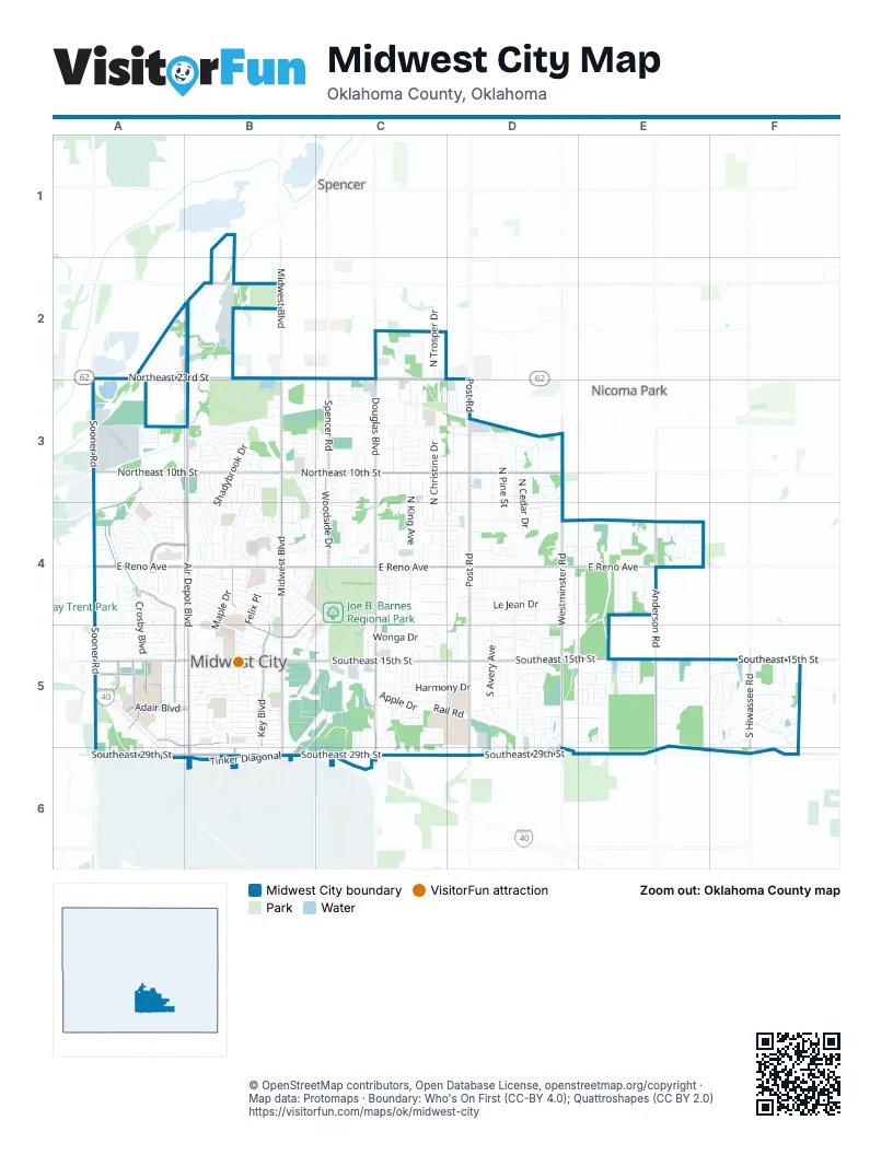
Street index of Midwest City
Each street on the sheet and the grid squares it crosses.
- Tinker DiagonalA5, A6, B6, C6
- North Air Depot BoulevardB3, B4
- South Air Depot BoulevardB4, B5, B6
- Northeast 23rd StreetA2, B2, C2
- East Reno AvenueA4, B4, C4, D4, E4
- Southeast 15th StreetA5, B5, C5, D5, E5, F5
- Southeast 29th StreetA6, B6, C6, D6, F6
- Northeast 10th StreetA3, B3, C3, D3
- North Midwest BoulevardB2, B3, B4
- North Douglas BoulevardC2, C3, C4
- South Post RoadD4, D5, D6
- South Midwest BoulevardB4, B5, B6
- South Douglas BoulevardC4, C5, C6
- South Sooner RoadA4, A5
- North Sooner RoadA3, A4
- Northeast 36th StreetB2
- North Meadowood DriveA4
- Industrial BoulevardC6
- A AvenueB6
- North Post RoadD2, D3, D4
- South Westminster RoadD4, D5
- South Anderson RoadE4, E5, E6
- North Key BoulevardB4, B5
- North Westminster RoadD3, D4
- Sandra DriveA4, A5
- Adair BoulevardA5, B5
- North Meadow LaneA4, B4
- South Hiwassee RoadF5, F6
- Hudiburg DriveA5
- Woodside DriveC3, C4
- Spencer RoadC3
- East Steed DriveB4, B5
- Warren DriveA5
- North Anderson RoadE4
- Will Rogers RoadA5
- West Boeing DriveA5, B5
- Johnson BoulevardA5
- East Turnbull StreetB5, B6
- College DriveA5
- Shadybrook DriveB3, B4
- Northeast 16th StreetB3, C3
- Timber Ridge BoulevardF5, F6
- Northeast 4th StreetC4, D4
- Northeast 12th StreetC3, D3
- West Silver Meadow DriveA3, A4, B4
- Union Pacific Rail YardA3
- East Rose DriveB4, C4, B5
- North Glenhaven DriveB3, B4
- Felix PlaceB4, B5
- Apple DriveC5
- Sunvalley DriveA3, A4
- Mockingbird LaneB3, B4
- North King AvenueC3, C4
- Morris McGee DriveC4, C5
- Southeast 17th StreetB5, C5, D5, F5
- South Avery AvenueD5
- North Christine DriveC3, C4
- Southeast 3rd StreetA4, C4, D4
- Harmony DriveC5, D5
- Parklawn DriveB4, C5
- Southeast 10th StreetA5, D5
- Ferguson DriveB5, C5
- Maple DriveB4, B5
- Southeast 5th StreetA4, B4
- Le Jean DriveD4
- Bellview DriveD4
- Southwest 17th StreetB5
- North Bella Vista DriveB3, B4
- Bowman DriveB5, C5, B6
- East Lockheed DriveB5
- Palmer DriveB5, B6
- North Marshall DriveB5, B6
- Crosby BoulevardA4, A5
- Southeast 12th StreetA5, D5
- Nawassa DriveC4
- Southeast 18th StreetB5, C5, F5
- East Robin RoadE4
- Liberty ParkwayA5, A6
- Forest Glen DriveF5
- Northeast 13th StreetC3
- Northeast 20th StreetB3, C3
- East Main StreetC4
- North Pine StreetD3, D4
- Oak Park DriveD4, C5
- Northeast 7th StreetD3
- Northeast 19th StreetC3, D3
- Rhythm RoadC5
- Cambridge DriveB3
- National AvenueB4
- East Grumman DriveB5
- Lloyd DriveD3
- Southeast 28th StreetD5, E5, C6
- East Cardinal PlaceC4
- North Cedar DriveD3, D4
- Northeast 17th StreetC3, D3
- North Lotus AvenueD3, D4
- Southeast 9th StreetA4, D4, D5
- East Northrup DriveB5
- North Poplar LaneD3, D4
- Northeast 5th StreetC4, D4
- Jaycie CircleE5
- Southeast 6th StreetA4, C4
- Wonga DriveC5
- Robin RoadB4
- Country LaneE4
- East Boeing DriveB5
- Northeast 3rd StreetC4, D4
- North Ridgewood DriveB3, B4
- East Kerr DriveB4
- Gayle DriveD5, D6
- Southeast 23rd StreetD5
- East Curtis DriveB5
- East Fairchild DriveB5
- Elizabeth DriveE4
- North Rulane DriveA4, A5
- Rolling LaneA3, A4
- Windsong DriveD5
- East Jarman DriveB4, B5
- West Blueridge DriveA3, B3
- South Moore AvenueD4, D5
- Woodland DriveC3, C4
- Symphony LaneC5
- Murray DriveB4
- Belmont AvenueD4
- East Douglas DriveB5
- Southeast 14th StreetD5
- East Harmon DriveB5
- Southeast 4th StreetA4, C4
- North Saint Peter StreetC2, C3
- West Fairchild DriveA5, B5
- West Rickenbacker DriveB5
- North Trosper DriveC2
- North Grandview RoadC4
- Oakview DriveC3, C4
- South Webster DriveD5
- Moraine AvenueC3, C4
- Marydale AvenueC3
- South Margene RoadC4
- North White Oak StreetD3, D4
- South Saint Paul AvenueC4
- North Shady Nook WayC2
- Northeast 15th StreetC3
- Morningside DriveB4
- Tumilty AvenueD3
- East Atkinson DriveB5
- Helm DriveE4
- Orchard BoulevardC5
- Southeast 8th StreetA4
- Flannery DriveB4, C4
- North Glenoaks DriveA4
- West Michael DriveB3
- Monroney DriveB5, B6
- Parkwoods LaneC3, C4
- Southeast 7th StreetA4
- Locust DriveB3, C3
- Sheffield StreetD5, E5
- Shapard DriveE4
- Snapper LaneD5, D6
- South Friendly DriveD4
- South Willow Wind DriveC5, D5
- North Saint Luke StreetC2, C3
- Buena Vista AvenueA4, A5
- West Campbell DriveB3
- Albert DriveC5
- Babb DriveB5
- South Roselawn AvenueD4
- Rail RoadC5, D5
- Bonaparte BoulevardB3
- Askew DriveA5, B5
- Bella Vista DriveB3, B4
- Caton PlaceD3
- North Glenvalley DriveA4
- Saint Patrick DriveD4
- Park DriveC5
- Three Oaks DriveC4
- East Ercoupe DriveB5
- Red Oak DriveF5
- North Holman CourtB3, B4
- Southeast 19th StreetD5, F5
- West Douglas DriveA5, B5
- Jet DriveA5
- Roefan RoadD5, E5
- Elm StreetB5
- North Juniper AvenueC3, C4
- Windsor WayB3
- South Harr DriveA5, A6
- Ballad DriveC5
- Morgan PlaceC5, C6
- Northeast 11th StreetC3, D3
- Wilson DriveB5
- East Rickenbacker DriveB5
- Joe B Barnes DriveC4
- Country Club TerraceB4
- Country Club CircleB4
- East Coe DriveB4
- West Ercoupe DriveA5, B5
- North Outpost DriveC2
- Oak Grove DriveB3, B4
- Showalter DriveB5
- McGregor DriveC3
- West Curtis DriveA5, B5
- Dorchester RoadE5
- East Frolich DriveB4
- Lakeside DriveE5
- Mc Donald DriveC3
- Mill Creek WayF5
- West Lilac LaneB5
- East Bouse DriveB4
- East Aeronica DriveB6
- Bell DriveA5
- Crest DriveC5, D5
- Lyric LaneC5
- Stansell DriveA5
- Water Plant RoadD5
- Rosewood DriveB3
- South Lawson AvenueD4
- Glenmanor DriveA3, A4
- East Key BoulevardB4
- South Davidson RoadC4
- South Acres DriveE4
- Hedge DriveB4, B5
- West Jarman DriveB4
- West Idylwild DriveA3, A4
- Southeast 21st StreetD5, F5
- Melody DriveC5
- East Kittyhawk DriveB5
- National BoulevardC4, B5, C5
- Blue Sky DriveD3, D4
- Meadowbrook DriveB3, B4
- Stone Ridge LaneE4
- North Westmoreland AvenueD3
- Loftin DriveC3
- South Meade DriveD5
- General Senter DriveB4
- South Caldwell DriveC5
- Holloway DriveA4
- Shirley DriveF5
- Timber RoadD3, D4
- Buckboard LaneE4
- North Redbud DriveB5
- Southeast 11th StreetA5
- West Pratt DriveB4
- Oakwood East BoulevardE5
- Lynn Fry BoulevardD5
- Village AvenueD5, E5
- Arthur DriveA4
- Shirley LaneF5
- Champoli DriveE5, F5
- Goldsborough RoadE4
- Northeast 2nd StreetC4, D4
- West Silverwood DriveB3
- Century BoulevardC5
- North Idylwild DriveA4
- North Richards AvenueC4
- West Coe DriveB4
- Russell DriveB5
- Hazelwood DriveB4, C4
- Crescent CircleA3, A4
- North Randolph DriveC2, C3
- West Kerr DriveB4
- Songbird LaneD5
- Northeast 3rd PlaceC4, D4
- Turtle Back DriveD5
- South Timber LaneD4
- West Glenhaven DriveB4
- Belaire DriveB4
- Ridgehaven DriveB3
- Brook DriveF5
- Turner DriveB4
- Royal AvenueD3, D4
- Givens DriveB5
- Republic AvenueB5, C5
- Rolling Meadows BoulevardB3
- Alicia DriveD5
- Wheeler PlaceA5, A6
- Big Oak DriveB4, C4
- Indian DriveB5, C5
- Delia StreetA4
- Honeysuckle LaneD5
- North Shadywood DriveB3
- Meadowlark LaneD5
- North Viewpoint DriveA4
- North Towry DriveB4
- Mark TrailD3
- East Ridgewood DriveB4
- Woody DriveB5, C5
- Austrian Pine DriveF5
- East Jacobs DriveB5
- North Mitchell DriveA4, A5
- South Texas AvenueD4
- Willow Brook DriveB3, C3
- Thorton DriveB4
- West Greenwood DriveA4
- Woodvale DriveB3, B4
- Tuscany Ridge RoadE5
- Rolling Lane CircleA3
- Stonecrop DriveC3
- East Beard DriveB4
- North Peebly DriveA4
- Slim DriveD3, D4
Things to do on the Midwest City map
Places on the map
- Alfalfa Grove Park
- AllianceHealth Midwest
- American Self Storage
- Atkinson Heritage Center
- Bowling Green
- Carl Albert High School
- Crutcho Creek Sod Farm
- Esa Park
- Gateway Shopping Center
- Good Shepherd Lutheran Church
- Heritage Plaza
- Holiday Square
- Jarman Middle School
- Joe B. Barnes Regional Park
- John Conrad Regional Golf Course
- Kiwanis Park
- Lions Park
- Marion C. Reed Ballpark
- Mid-America Park
- Midwest City City Hall
- Midwest City High School
- Midwest City Library
- Oakwood East Park
- Soldier Creek Industrial Park (SCIP)
- Sooner Park
- Telstar Elementary School
- Telstar Park North
- Tinker Business and Industrial Park
- Tom Poore Park
- Town and Country Center
- Union Pacific Rail Yard
- Uptown Center
- Walmart Supercenter
- White Trail
- Windmill Farms
- Yellow Trail
Next to Midwest City
- Nicoma Park
- Spencer
© OpenStreetMap contributors, Open Database License, openstreetmap.org/copyright · Map data: Protomaps · Boundary: Who's On First (CC-BY 4.0); Quattroshapes (CC BY 2.0)















