

Oklahoma map
Moore map
About 63,845 people live here (Census Bureau, 2024 estimate). The sheet's index lists 300 streets; South Bryant Avenue, Southeast 8th Street and Helen Cole Memorial Highway cross the most grid squares. Also on it: 7-Eleven, Air Comfort Solutions and ALDI.
Open the map (PDF, US Letter)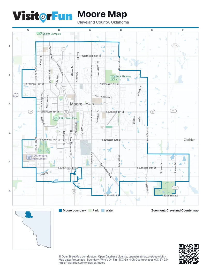
Street index of Moore
Each street on the sheet and the grid squares it crosses.
- Helen Cole Memorial HighwayB1, B2, B3, B4, B5
- North Janeway AvenueB1, B2, B3
- Shields BoulevardB1, B2
- South Shields BoulevardB1
- South Eastern AvenueC1, C3, C4, C5, C6
- Northeast 12th StreetB2, C2, D2, E2
- South Telephone RoadB3, B4, B5, B6
- I-35 W Frontage RdB3, B4, B5, B6
- Southeast 19th StreetC4, D4, E4
- Southeast 4th StreetC3, D3, E3
- North Eastern AvenueC1, C2, C3
- Northeast 27th StreetB1, C1, D1
- North Santa Fe AvenueA1, A2, A3
- South Santa Fe AvenueA4, A5
- North Moore AvenueB1, B2, B3
- North Broadway StreetB1, B2, C3
- Northwest 12th StreetA2, B2
- East Main StreetC3, D3
- Southwest 19th StreetA4, B4, C4
- Southwest 4th StreetA3, B3, C3
- South Broadway StreetC3, C4
- I-35 E Service RdB4, B5
- West Main StreetA3, B3, C3
- Northwest 27th StreetA1, B1
- East Service RoadB2, B3
- North Interstate Highway 35 Frontage RoadB1, B2
- Sooner RoadF5, F6
- South Interstate Highway 35 Service RoadB3
- 12th Avenue NortheastF6
- West Service RoadB2, B3
- North Broadway AvenueB1
- North Interstate Highway 35 Service RoadB1
- South Sooner RoadF5
- North Service RoadB1
- Main StreetC3
- South Bryant AvenueD1, D2, D3, D4, D5, D6
- Southeast 34th StreetC5, D5, E5, F5
- South Sunnylane RoadE3, E4, E5, E6
- Southwest 34th StreetA5, B5, C5
- South BroadwayC4, C5, D5, D6
- Northwest 5th StreetA3, B3, C3
- Southwest 11th StreetA4, B4, C4
- North Bryant AvenueD2, D3
- Southwest 30th StreetA5, B5, C5
- Southwest 28th StreetA5, B5, C5
- Whispering Oaks StreetD3, D4
- Tower DriveC3, C4
- West Indian Hills RoadC6, D6
- South Howard AvenueB3, B4
- South Janeway AvenueB3, B4
- North City AvenueB2, B3
- East Indian Hills RoadE6, F6
- Southwest 4th PlaceA3, B3
- Fritts BoulevardB4, B5
- North Markwell AvenueB2, A3, B3
- Glenn Lewis BoulevardB5
- Southwest 25th StreetA5, B5
- Veterans ParkwayD3, D4
- Phillips AvenueD5
- North BroadwayD6
- South Classen AvenueB3
- North Telephone RoadB3
- Max Morgan BoulevardB4
- South Markwell AvenueA3
- Riverwalk DriveB4
- Southeast 149th StreetE4
- Wilson BoulevardA3
- SouthWest ConnectionB5
- SouthEast ConnectionB5, C5
- Fleshman DriveB5
- Interstate DriveB5
- 36th Avenue NorthwestB6
- Southeast 8th StreetC3, D3, E3, C4, D4, E4
- Southwest 1st StreetA3, B3, C3
- East Hills DriveC1, C2
- Southeast 38th StreetD5, E5
- Sooner DriveE5, E6
- Northwest 1st StreetA3, B3, C3
- Southeast 12th StreetC4, D4
- Northeast 4th StreetC3, D3, E3
- Nail ParkwayB1, C2, C3
- Southeast 5th StreetC3, D3, E3
- Northeast 18th StreetB2, C2, D2
- Southwest 14th StreetA4, B4, C4
- Southwest 2nd StreetA3, B3, C3
- North Lincoln AvenueC1, C2
- Pole RoadC1, C2
- Northwest 8th StreetB2, A3, B3
- Southeast 9th StreetC4, D4, E4
- Southwest 3rd StreetA3, B3, C3
- Northeast 10th StreetB2, C2, D2, E2
- North Norman AvenueB2, B3
- Northeast 9th StreetB2, C2, D2, E2
- Eagle DriveA3, A4, B4
- Southeast 6th StreetC3, D3, E3
- Northeast 5th StreetC3, D3, E3
- Northeast 19th StreetB2, C2
- Northeast 23rd StreetC1, B2, C2
- Southwest 10th StreetA4, B4, C4
- Northwest 15th StreetA2, B2
- Westmore DriveA4, A5
- Northwest 2nd StreetA3, B3, C3
- Southwest 40th StreetB5, C5, A6
- Bellaire DriveB1, B2
- North Gale StreetB2, B3
- South Patterson DriveC3, C4
- Penn LaneA3, A4
- Southwest 31st StreetA5, B5
- Southeast 14th StreetC4, D4
- Northwest 9th StreetA2, B2
- Southeast 13th StreetC4, D4
- Southwest 42nd StreetC5, C6
- Queensbury RoadA1, A2, B2
- Northwest 19th StreetA2, B2
- South Bouziden DriveC3, C4
- Regency BoulevardB1, A2, B2
- Southwest 12th StreetA4, B4, C4
- Southeast 15th StreetD2, C4, D4
- North Southminster StreetA2, A3
- Southeast 7th StreetD3, E3, D4
- Northeast 2nd StreetC3, D3
- Northeast 1st StreetC3, D3
- Northeast 7th StreetB3, C3, D3, E3
- Sunrise StreetB2
- Northeast 11th StreetB2, C2, D2
- Lakecrest DriveA2, A3, A4, A5
- Southwest 13th StreetA4, B4, C4
- Southeast 10th StreetC4, D4, E4
- Northeast 6th StreetC3, D3
- Kings RoadA1, A2
- Northwest 14th StreetA2, B2
- Northwest 6th PlaceA3
- South Avery DriveC3, C4
- South Morgan DriveC3, C4
- Lago DriveA5, B5, A6
- Southwest 33rd StreetA5, B5
- Southeast 2nd StreetC3, D3
- Southwest 8th StreetA4, B4, C4
- Southwest 39th StreetC5
- Old Mill RoadC1, C2
- Glenwood DriveC3, C4
- Lonnie LaneA3, A4, A5
- Northeast 3rd StreetC3, D3
- Lawton StreetB2, B3
- Cedar LaneB1, C1, C2
- Northwest 20th StreetA2, B2
- Vista DriveF5, F6
- Northeast 14th StreetC2, D2, E2
- Northeast 8th StreetD2, B3, C3, D3
- Southwest 6th StreetA3, B3, C3
- Southcreek roadF5
- Southeast 27th StreetC5, E5
- Willow Bend BoulevardB5
- Northwest 18th StreetA2, B2
- Southwest 32nd StreetA5, B5, C5
- Northwest 22nd StreetA2, B2
- Northwest 7th PlaceA3
- Southwest 38th StreetB5, C5
- Southeast 1st StreetC3, D3
- Northeast 21st StreetB2, C2
- Kelsi DriveD3, D4
- Southeast 16th StreetC4, D4
- Camelot StreetB2
- Fox AvenueB2, C2
- Willow Pine DriveC5, D5
- Northeast 20th StreetB2, C2
- North Windemere DriveA2, B2
- Southwest 24th StreetB4, A5
- North Ramblin Oaks DriveD2, D3
- Southeast 11th StreetC4, D4, E4
- Northwest 23rd StreetA2, B2
- South Silver Leaf DriveC3
- Oak Creek DriveD2, D3
- Southwest 15th StreetA4, B4, C4
- Woodlawn DriveB1
- Poplar DriveB1
- Hillcrest DriveB1
- Northwest 21st StreetA2, B2
- Hilltop DriveE2, E3
- West Lake RoadF5
- Northwest 34th StreetA1, B1
- North Morgan DriveC2, C3
- Cottonwood DriveD3, D4
- Crystal DriveC4, C5
- Northeast 26th StreetC1, D1
- North Robinson AvenueA2, A3
- Messenger DriveC2, C3
- Larkspur RoadA1
- North Patterson DriveC3
- Stoneridge DriveC3, C4
- Oak DriveA5
- Southeast 30th StreetC5, D5, F5
- DaleE2, E3
- Heather LaneB3, B4
- Northwest 6th StreetA3, B3
- Monica LaneB5
- North Nottingham WayB1, B2
- Northwest 7th StreetA3, B3
- RyanE3, E4
- Meadow Run DriveD4
- Estell DriveD2, D3
- David RoadD2, D3
- Churchill RoadE5, E6
- Hidden Lake CircleB5, B6
- Highland DriveB1, B2
- Southeast 3rd StreetC3, D3
- Kensington DriveC5, C6
- Northwest 24th StreetA1, B1, A2
- Northwest 17th StreetB2
- Northeast 25th StreetC1, D1
- Crestmoore DriveC2, C3
- Northwest 35th StreetA1, B1
- Southeast 24th StreetC5
- Southwest 35th StreetB5, C5
- Woods WayC5
- Ridgewood DriveB1, B2
- Notting Hill DriveC5, C6
- North Wyndemere Lakes DriveD3
- Manhattan DriveC6
- Elmo WayC5
- Southeast 33rd StreetC5, D5, E5
- Clear Creek RoadD2
- Northwest 10th StreetA2
- Northwest 16th StreetB2
- PadenE2, E3
- Woodstock RoadC5
- Winding Creek RoadC2
- Elizabeth Anne TerraceC5
- Southwest Mc Kenzie DriveC5, C6
- Northeast 16th StreetC2
- Ridgeway DriveB4
- Lindsey LaneE3, E4
- Samantha LaneE3, E4
- South Olde Bridge RoadD3
- South English StreetC3, C4
- Riverside DriveD3
- Crosstimbers DriveC4
- Mc kenzie DriveC6
- Shady Creek LaneD5, E5
- Southwest 20th StreetA4
- Southwest 16th StreetA4, B4, C4
- Cass AvenueB1
- Brush Arbor DriveB5
- Jury LaneC4
- Central Park AvenueC5, C6
- Northeast 32nd StreetC1, D1
- North Silver Leaf DriveC2, C3
- Ashwood LaneD3, D4
- Flicker RidgeC2
- Twin Lake DriveF5
- Butler StreetA3, B3
- Southeast 39th StreetD5, E5
- Northridge RoadC1, C2
- South Ramblin Oaks DriveD3
- SherryE2, D3, E3
- Mead LaneA2
- Southwest 27th StreetB5, C5
- South Irving DriveB3
- South Dallas AvenueB3
- Bronze Medal RoadD2, D3
- Southeast 18th StreetD4
- Kelley DriveB3
- Sutton CircleB2, D4
- Cavalier StreetB2
- Southeast 40th StreetD6, F6
- Sweetgum StreetD3, D4
- Clover RoadC4
- Fire Light DriveC2
- Southwest 7th StreetB3, C3, B4
- Northeast 24th StreetC2
- Sequoyah AvenueC1, C2
- Tudor DriveA2, B2
- South Norman AvenueB3
- Burn Pit RoadF6
- Kings CourtA2, A3
- North Bristow AvenueB3
- South Bristow AvenueB3
- Southwest 31st TerraceA5, B5
- Southwest 45th StreetC6
- Saint George PlaceA2, B2
- Elmhurst StreetC2, C3
- Acoma DriveB5, B6
- Wilkinson DriveC3
- North Dallas AvenueB3
- Hillsboro Free Will Baptist RoadB6
- North Hickory LaneD3
- Vermeer DriveB2
- Kings ManorB3, B4
- Jordan DriveD4
- Southwest 9th StreetB4, C4
- Briarcliff DriveA4, A5
- January PlaceD4
- Northwest 14th PlaceA2
- Wimberley Creek DriveD4
- Berwyck DriveC2, C3
- Sendera Lakes DriveB5
- Carol Ann PlaceC5
- San Juan TrailC5
- Highlander DriveC2, C3
- Northeast 31st StreetD1
Places on the map
- 7-Eleven
- Air Comfort Solutions
- ALDI
- Apple Creek Elementary
- Apple Valley Park
- Arbor Gardens
- Arvest Bank
- At Home
- AutoZone
- BancFirst
- Belmar Golf Club
- Black Bear Diner
- Braum's
- Broadmoore Elementary
- Buck Thomas Park
- Burlington
- Casey's General Store
- Central Elementary School
- Central Junior High School
- Central Park
- Chick-fil-A
- Chicken Express
- Fairmoore Park
- FedEx Office
- Houchin School
- Lake Woods Nature Park
- Little River Park
- Moore Cemetery
- Moore Golf Course
- Moore High School
- Mussel Shoals Lake
- Norman Regional Moore
- Oknoname 02724 Reservoir
- Oknoname 02725 Reservoir
- Southmoore High School
- The Curve Park
- The UPS Store
- Veterans Memorial Park
- Walmart Supercenter
- Westmore Trails Park
Next to Moore
- Clothier
© OpenStreetMap contributors, Open Database License, openstreetmap.org/copyright · Map data: Protomaps · Boundary: Who's On First (CC-BY 4.0); Quattroshapes (CC BY 2.0)