

Oklahoma map
Cleveland County map
About 303,952 people live here (Census Bureau, 2024 estimate). The sheet's index lists 97 streets; East Imhoff Road, North Main Street and Northwest 12th Street cross the most grid squares. Things to do inside the boundary: Museum of Osteology and Norman.
Open the map (PDF, US Letter)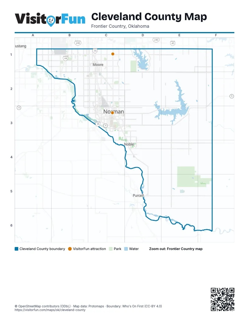
Street index of Cleveland County
Each street on the sheet and the grid squares it crosses.
- Northwest 12th StreetB1, C1
- South I-44 Service RoadB1
- South May AvenueB1
- South Pennsylvania AvenueB1
- South Portland AvenueB1
- South Walker AvenueB1
- South Western AvenueB1, B2
- South Will Rogers ExpresswayB1
- Southwest 104th StreetB1, C1
- Southwest 119th StreetB1
- Southwest 134th StreetB1, C1
- Southwest 89th StreetB1, C1
- Will Rogers ExpresswayB1, B2
- East Main StreetC1, C3
- East Service RoadC1
- Helen Cole Memorial HighwayC1, C2
- I-35 W Frontage RdC1, C2
- North Broadway AvenueC1
- North Broadway StreetC1
- North Eastern AvenueC1
- North Interstate Highway 35 Frontage RoadC1
- North Interstate Highway 35 Service RoadC1
- North Janeway AvenueC1
- North Moore AvenueC1
- North Santa Fe AvenueC1
- North Service RoadC1
- Northeast 12th StreetC1
- Northeast 27th StreetC1
- Northwest 27th StreetC1
- Shields BoulevardC1
- South Broadway StreetC1, C2
- South Eastern AvenueC1, C2
- South High AvenueC1
- South Interstate Highway 35 Service RoadC1
- South Santa Fe AvenueC1, C2
- South Service RoadC1
- South Shields BoulevardC1
- South Sooner RoadC1, C2
- South Telephone RoadC1, C2
- Southeast 134th StreetC1
- Southeast 4th StreetC1
- Southeast 89th StreetC1, F1
- Southwest 4th StreetC1
- West Main StreetC1, C3
- West Service RoadC1
- Kickapoo TurnpikeF1
- South Newalla RoadF1, F2
- 60th Avenue NorthwestB2
- 12th Avenue NortheastC2, C3
- 24th Avenue NorthwestC2, C3
- 36th Avenue NorthwestC2, C3
- Doctor James E. and Representative Mina M. Hibdon Memorial HighwayC2, C3
- East Rock Creek RoadC2
- East Tecumseh RoadC2
- I-35 E Service RdC2
- North Flood AvenueC2, C3
- North Interstate DriveC2, C3
- North Porter AvenueC2, C3
- Rock Creek RoadC2
- Sooner RoadC2
- Southeast 19th StreetC2
- Southwest 19th StreetC2
- West Rock Creek RoadC2
- West Tecumseh RoadC2
- 192nd Avenue NortheastF2, F3
- 12th Avenue SoutheastC3
- 24th Avenue SouthwestC3
- 36th Avenue SouthwestC3
- Chautauqua AvenueC3
- Classen BoulevardC3, D3
- East Alameda StreetC3
- East Cedar Lane RoadC3, D3
- East Constitution StreetC3
- East Gray StreetC3
- East Imhoff RoadC3, D3, E3
- East Lindsey StreetC3
- East Robinson StreetC3
- Ed Noble ParkwayC3
- Imhoff RoadC3
- Jenkins AvenueC3
- McCall BridgeC3
- South Classen BoulevardC3
- South Porter AvenueC3
- West Gray StreetC3
- West Lindsey StreetC3
- West Robinson StreetC3
- World War I Veterans Memorial HighwayC3
- 24th Avenue SoutheastD3
- North Main StreetD3, D4, D5
- OK 9D3
- East Robinson RoadE3
- 72nd Avenue SoutheastD4, D5
- Blue Star Memorial HighwayD4
- South Main StreetD4
- East Broadway StreetD5
- James C. Nance Memorial BridgeD5
- West Broadway StreetD5
Things to do on the Cleveland County map
Places on the map
- Al Salyer Reservoir
- Armed Forces Support Center
- Ashton Grove
- Aspen Heights Norman
- Azalea Farms
- Behavioral Health Center at Porter Health Village
- Bell Mere Lake
- Belmar Golf Club
- Bluestem Ridge
- Briarwood Creek
- Buck Thomas Park
- Castlerock
- Cedar Terrace
- Cleveland County
- Cobblestone Creek Golf Course
- Colonial Estates
- Cottonwood Ridge Condos
- Crossroads Sports Complex
- Crosstimbers Off-Road Vehicle Park
- Crystal Hieghts
- Dahlgren Lake
- Dove Caynon
- Downtown
- Eagle Ridge
- Earlywine Golf Club
- Earlywine Park
- Eastridge
- Etowah
- Flaming Oaks
- Forrest Hills
- Griffin Community Park
- Griffin Memorial Hospital
- Hall Park / Hallbrooke
- Hall Park Lake
- Highland
- Hunter's Place
- Irving Middle School
- Jamestown
- Jimmie Austin Golf Club
- Joseph Harp Lexington Correctional Center
Next to Cleveland County
- Mustang
- Purcell
© OpenStreetMap contributors (ODbL) · Map data: Protomaps · Boundary: Who's On First (CC-BY 4.0)