

Oklahoma map
Muskogee map
About 36,849 people live here (Census Bureau, 2024 estimate). The sheet's index lists 300 streets; Muskogee Turnpike, South Cherokee Street and Thunderbird Speedway cross the most grid squares. Things to do inside the boundary: Three Rivers Museum.
Open the map (PDF, US Letter)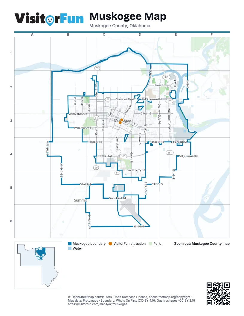
Street index of Muskogee
Each street on the sheet and the grid squares it crosses.
- Muskogee TurnpikeE1, E2, E3, E4, E5
- East Shawnee BypassD2, E2
- South 32nd StreetC3, C4, C5
- West Shawnee BypassC2, D2
- West Okmulgee AvenueB3, C3, D3
- East Peak BoulevardC4, D4
- West Peak BoulevardC4
- North Country Club RoadE2, E3
- North Main StreetD2, D3
- North 32nd StreetC2, C3
- North 24th Street WestC2, C3
- North 32nd Street WestC2
- North 14th StreetC2, C3
- North 6th StreetC2, C3
- North 17th Street WestC2, C3
- Euclid AvenueD2
- South Main StreetC3, D3
- Specialist Joshua M. "Bubba" Seals Memorial BridgeC1
- South 32nd Street WestC4
- Azalea Park DriveC2
- Shawnee BypassC2
- North York StreetD1, D2, D3
- Chandler RoadD3, E3
- South York StreetD3, D4
- East Okmulgee AvenueD3
- East Side BoulevardD3
- West Shawnee StreetB2, C2, D2
- South 24th Street WestC3, C4, C5
- West Broadway StreetB3, C3, D3
- Gulick StreetD3, D4, D5
- Gibson StreetD3, E3
- North 43rd Street EastE2, E3
- North 41st Street EastE2, E3
- West Hancock RoadA4, B4, C4
- East Hancock StreetD4, E4
- Old Shawnee RoadD2, E2
- Columbus AvenueC3, D3
- East Harris RoadD2, E2
- East Smith Ferry RoadC4, D4, E4
- East Hancock RoadC4, D4, E4
- West Border AvenueB3, C3
- Callahan StreetD3, E3
- Elgin StreetC3
- East Shawnee RoadD2, E2
- East Augusta AvenueD3, E3
- West Martin Luther King StreetC3, D3
- North StreetD3, E3
- South Country Club RoadE3, E4, E5
- South 40th StreetC3, C4
- Port PlaceE2
- South Cherokee DriveC4
- East Broadway AvenueD3
- North 54th StreetB2, B3
- North 11th Street WestC2, C3
- North 40th StreetC2, C3
- North 48th StreetB2, B3
- Arline StreetC3
- South 43rd Street EastE3, E4
- Military BoulevardC2, C3
- South 41st Street EastE3, E4
- South Junction StreetC3
- South 12th StreetC3
- North 3rd StreetC3, D3
- North 12th StreetC2, C3
- East Independence StreetC3, D3
- West Kalamazoo StreetC3
- Beacon StreetD2, D3
- North 7th StreetC3
- South 7th StreetC3
- Border AvenueC3
- Spaulding BoulevardD3
- South L StreetD3
- Dal Tile RoadC4
- South K StreetD3
- East Cincinatti AvenueD3
- West Southside BoulevardC3
- South 37th StreetC3
- Don Cayo DriveE2
- West Broadway AvenueC3
- Old Taft RoadB3
- Kinney StreetD3, D4
- Arline Street AvenueC3
- West 53rd Street SouthB5, C5
- South Cherokee StreetC3, D3, C4, C6
- Denison StreetB3, C3, D3
- South 40th Street WestC4, C5, C6
- Court StreetC3, D3
- Denver AvenueC3
- West 83rd Street SouthC6
- Irving StreetD3, E3
- South 6th Street WestC3, C4
- Fredonia StreetD3
- South 64th Street WestB4, B5
- Dayton StreetD3
- Honor Heights DriveB2, C2, C3
- Haskell BoulevardD3, E3
- South 25th Street EastD5, D6
- South 45th Street EastE3, E4, E5
- Jefferson StreetD3, E3
- Eufaula StreetD3, E3
- Boston StreetC3
- East 83rd Street SouthD6
- Emporia StreetB3, C3
- East Davis Field RoadC5, D5
- East 53rd Street SouthC5, D5, E5
- Houston StreetD3
- West Davis Field RoadB5, C5
- Indiana StreetD3, D4
- Turner StreetD4
- North 55th Street EastE1, E2
- Georgia AvenueD4, E4
- Elmira StreetD3
- Sally Brown RoadE4
- South 20th Street EastD5, D6
- Tull AvenueD3, E3
- Lawrence StreetD3
- East Monta AvenueD3
- Baltimore StreetD3
- Oklahoma StreetB3, C3
- North Virginia StreetD3
- Tamaroa StreetC3, D3
- North Edmond StreetD2, D3
- South 26th StreetC3, C4
- South 74th Street WestA4
- Gawf LaneD3, D4, E4
- South 54th StreetB3
- Chestnut StreetD3
- Dorchester AvenueD3
- East 40th Street NorthE1, E2
- North F StreetD3
- South B StreetC3, D3
- Summit StreetD3
- Kershaw DriveB3
- South 21st StreetC3
- Sallie AvenueD3
- North 16th StreetC2, C3
- Hayes StreetD3
- North C StreetD3
- South 23rd StreetC3
- Old Bacone RoadD2
- South 4th StreetC3, C4
- North Utah StreetD3
- South 30th StreetC3
- North Washington StreetD2, D3
- Kimberlea DriveD2, E2
- Chicago AvenueD2, D3
- North Cherokee StreetD3
- Kentucky StreetD3, D4
- North K StreetD3
- Robison StreetD3
- North L StreetD3
- North 13th StreetC2, C3
- North Mill StreetD3
- Kingston StreetD3
- Girard StreetB3, C3, D3
- Estelle AvenueB3, C3
- South 5th StreetC3, C4
- Canterbury AvenueD3, E3
- South 2nd StreetC3, D3
- South C StreetC3, D3
- East Woodland CircleD4
- Manitou StreetD3
- Spruce AvenueD2, D3
- South 29th StreetC3
- North 5th StreetC2, C3
- North 18th StreetC2, C3
- Grandview BoulevardC4, D4
- Fremont AvenueC3
- N4340E2
- North 45th Street EastE2, E3
- South 3rd StreetC3
- Hilltop AvenueD3
- South G StreetD3
- Robin LaneD2
- Taladega StreetC2, D2
- Tennyson StreetB3, C3
- Inman StreetC3
- North 15th StreetC2, C3
- Walnut StreetD2, D3
- Batfish RoadE2
- North M StreetD3
- Oklahoma AvenueC3
- South Virginia StreetD3, D4
- Foltz LaneD3, D4
- North Anthony StreetD3
- Queens RoadD4
- Galveston StreetD3
- PembrokeC4, D4
- Garland StreetC3
- Locust StreetD2, D3
- Howard StreetB3, C3, D3
- South 28th StreetC3, C4
- Austin StreetC2, D2
- Elizabeth AvenueC3
- East Cincinnati AvenueD3
- Indianapolis AvenueC3
- Horn StreetD3
- North G StreetD3
- Tull PlaceD3, E3
- South 13th StreetC3
- East Monta PlaceD3, E3
- Pickens AvenueD2
- South D StreetD3
- South 8th StreetC3
- Jeannie LaneD3, E3, D4
- South Utah StreetD3, D4
- Wewoka StreetC2, C3
- North David LaneD3
- South 11th StreetC3
- North N StreetD3
- East 21st Street NorthE2
- Findlay AvenueC3
- Haddock DriveC4
- North Country Club CircleE2
- Cherry StreetD3
- State College RoadE2
- South Hatbox RoadC3
- North 9th StreetC3
- South 46th Street EastE3, E4
- Park BoulevardC3
- East Kalamazoo AvenueC3, D3
- North 21st StreetC2, C3
- Maple StreetD3
- North 49th Street EastE1
- East 61st Street SouthD5
- North J StreetD3
- Cobblestone DriveD4
- South 10th StreetC3
- North 17th StreetC3
- South 14th StreetC3
- North 34th StreetC2, C3
- River Bend RoadD2, E2
- Delaware StreetD3, E3
- South Katy StreetC3
- Kingsway StreetD4
- Live Oak StreetD2, D3
- Reeves StreetD2
- Azalea DriveC4
- Illinois StreetD3, D4
- Callery DriveE3
- Phantom RoadD5, D6
- Out of Bounds DriveD4
- Patterson StreetD3, D4
- Orchard ParkwayD4, D5
- North 26th StreetC3
- North 52nd StreetB3
- Tahlequah StreetC2
- North 28th StreetC3
- North 10th StreetC3
- Sheffield AvenueC4, D4
- Enid AvenueD3
- Miller StreetC2, D2
- Bacone StreetD3, D4
- North 11th StreetC3
- Sandow StreetD2
- Lenapah StreetC3
- Michael RoadE2
- South 9th StreetC3
- Trumbo StreetD3, D4
- Poplin AvenueD4, D5
- Mustang StreetD5, D6
- Cook StreetD3, D4
- West Rolling Oaks DriveB3
- Carolyn StreetC3
- Thunderbird SpeedwayC3, D3, C4, D4
- Ash StreetD3
- North 27th StreetC3
- Cary PlaceC4, D4
- River Oaks DriveD2, E2
- North 38th StreetC2, C3
- North 4th StreetC3, D3
- Quail RunD5
- Barclay RoadD4
- Wood StreetD3
- Harris AvenueD2, E2
- Georgetown AvenueC3
- Williams AvenueC3
- Club View DriveE2
- Three Forks RoadE2
- Valhalla DriveC4, D4
- Rutherford StreetD4
- Prairie Dog RoadD4, D5
- Mulberry StreetD3
- Kenesaw StreetD2
- Martin StreetC2, D2
- North 44th StreetB3
- Park DriveD3
- South 22nd StreetC3
- Leathers LaneB3
- West Harris StreetC4
- Country Club DriveE2
- West 33rd Street SouthB4
- Geneva AvenueC3, D3
- Burbank StreetD4
- North B StreetD3
- East Madison AvenueC3, D3
- Kankakee StreetD3
- North P StreetD3
- North 45th StreetB3
- South M StreetD3
Things to do on the Muskogee map
Places on the map
- Agency Hill
- Alta Vista
- Arrowhead Mall
- Brown's Subdivision
- Canard Subdivision
- City of Muskogee Brush & Limb Drop-Off Site
- Civitan Park Trail
- Clubview Estates
- Cobblestone Estates
- Cobblestone Golf Course
- Eastpointe Business Park
- Founders Place
- Grandview Heights 7th Addition
- Green Hill Cemetery
- Hatbox Field
- Hidden Valley
- Honor Heights Park
- Hyde Park
- Kenwood
- Kershaw Heights
- Meadows Subdivision
- Muskogee County Fairgrounds
- Muskogee Golf Club
- Muskogee High School
- Muskogee-Davis Regional Airport
- Northpark
- Oklahoma School for the Blind
- Port of Muskogee
- Reeves Subdivision
- River Bend
- River City Plaza
- River Oaks
- Shawnee Crossing
- South Gulick The Farm
- Suroya Heights
- Sweet 16 Motocross Park
- The Woodlands
- Thunderbird Speedway
- University Heights
- West Alta Vista
Next to Muskogee
- Summit
© OpenStreetMap contributors, Open Database License, openstreetmap.org/copyright · Map data: Protomaps · Boundary: Who's On First (CC-BY 4.0); Quattroshapes (CC BY 2.0)















