

Oklahoma map
Payne County map
About 84,199 people live here (Census Bureau, 2024 estimate). The sheet's index lists 300 streets; E0740 Road, 42nd "Rainbow" Infantry Division Memorial Highway and East 6th Avenue cross the most grid squares. Things to do inside the boundary: Stillwater.
Open the map (PDF, US Letter)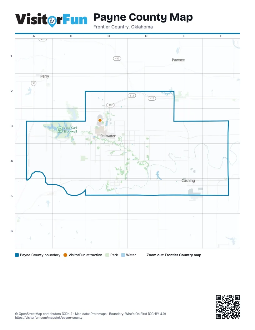
Maps inside Payne County
1 map inside, from the street map of Payne County down.
Street index of Payne County
Each street on the sheet and the grid squares it crosses.
- World War II Veterans Memorial HighwayA3, A4, A5
- Cimarron Turnpike SpurC2, D2
- Cimarron TurnpikeD2, E2
- 42nd "Rainbow" Infantry Division Memorial HighwayA3, B3, D3, E3
- East 6th AvenueC3, D3, E3, E5
- East 116th Street SouthC5, D5, E5
- West 6th AvenueA3, B3, C3, F3
- South Perkins RoadC3, C4, C5
- East Richmond RoadC3, D3, E3
- Jennifer Lea Briggs and Heather Wilson Memorial HighwayB5, C5
- South Jardot RoadC3, C4, C5
- North Washington StreetC2, C3
- North Perkins RoadC2, C3
- Jim Thorpe Memorial HighwayE3, F3
- West Richmond RoadB3, C3
- Veterans Memorial HighwayF5
- South Main StreetC3, F3, C4, C5
- East Main StreetE5
- North Main StreetC3, F3, C5
- West Main StreetD2, E5
- East Chicago AvenueF3
- West Chicago AvenueF3
- West Broadway StreetE5, F5
- Newt Sexton Memorial BridgeB5
- Larry Tomlinson Memorial BridgeC5
- East McElroy RoadC3, D3, E3, F3
- East Airport RoadC3, D3, E3, F3
- East Lakeview RoadC3, D3, E3
- South Western RoadC3, C4, C5
- South Country Club RoadC3, C4, C5
- North Rose RoadD2, D3
- North Jardot RoadC2, C3
- Specialist Jordan M. Morris Memorial HighwayD3, D4, D5
- Perry RoadA3, A4
- North Country Club RoadB2, C2, B3, C3
- West Lakeview RoadB3, C3
- North Western RoadC2, C3
- Twin Mounds RoadE3, E4
- North Little AvenueE4, E5
- Greenwood RoadF4, F5
- East 12th AvenueC3
- West Hall of Fame AvenueC3
- West 12th AvenueC3
- West Airport RoadC3
- South Duck StreetC3
- North Boomer RoadC3
- North Duck StreetC3
- Morton AvenueD4
- East Hall of Fame AvenueC3
- Council Valley RoadE3
- South Boomer RoadC4
- South Western AvenueC3
- East 44th StreetC4, D4, E4, F4
- Yost RoadB2, C2, D2, E2
- East 32nd StreetC4, D4, E4, F4
- East 68th StreetC4, D4, E4
- East Burris RoadC3, D3, E3
- South Sangre RoadC3, C4, C5
- South Union RoadD3, D4, D5
- South Fairgrounds RoadC3, C4, C5
- North Norfolk RoadF3, F4, F5
- South Range RoadB3, B4, B5
- South Prairie RoadD3, D4, D5
- East 92nd StreetC4, D4, E4
- South Coyle RoadB3, B4, B5
- East Lone Chimney RoadD2, E2
- South Rose RoadD3, D4, D5
- North Prairie RoadD2, D3, D4
- South Washington StreetC3, C4, C5
- North Union RoadD2, D3
- East 9th StreetE5, F5
- West McElroy RoadB3, C3
- South Redlands RoadB3, B4, B5
- East Dunkin RoadE4, F4
- West 68th StreetA4, B4, C4
- East 19th AvenueC3, D3
- East 56th AvenueC4, D4
- South Mehan RoadD3, D4
- West 19th AvenueB3, C3
- North Kings HighwayE4, E5
- North Linwood AvenueE4, E5
- McMurtry RoadB3, C3
- North Euchee Valley RoadF4, F5
- West 56th StreetA4, C4
- North Husband StreetC3
- North Fairgrounds RoadC3
- South Euchee Valley RoadF5
- South Little AvenueE5
- South Linwood AvenueE5
- West 32nd StreetC4
- West 128th StreetB5, C5
- West Dunkin RoadE4
- West 9th AvenueB3, C3
- West 26th AvenueC3, C4
- North Monroe StreetC3
- West 4th AvenueB3, C3
- West Virginia AvenueB3, C3
- West 3rd AvenueB3, C3
- West Moses StreetE5
- East Moses StreetE5
- East 3rd AvenueC3
- West University AvenueC3
- East Virginia AvenueC3
- East Knipe AvenueC5
- South Knoblock StreetC3
- South Lewis StreetC3
- South Hester StreetC3
- East Kirk AvenueC5
- West Freeman AvenueC5
- West Farm RoadC3
- West 47th AvenueC4
- North Sadler RoadC5
- North Hargis RoadC3
- South Monroe StreetC3
- Chronister RoadF4, F5
- Lovers LaneC5
- West Miller AvenueC3
- West Burris RoadC3
- East 9th AvenueC3
- East 18th AvenueC3
- North Airport Industrial Access RoadC3
- University CircleC3
- South Sadler RoadC5
- East Miller AvenueC3
- WashingtonC3
- ChisholmB3
- N3240 RoadB3
- East 19th StreetD3, E3, F3
- West 80th StreetA4, B4, C4
- Lakeview RoadA3, E3, F3
- West 44th AvenueA4, B4, C4
- East Glencoe RoadC2, D2, E2
- East 56th StreetD4, E4, F4
- West 92nd StreetA4, B4, C4
- Vassor RoadA3, A4, A5
- South Cottonwood RoadB3, B4, B5
- South Brush Creek RoadC3, C4, C5
- West 56th AvenueA4, B4, C4
- West 104th StreetA4, B4, C4
- North Clay RoadE2, E3, E4
- Hackelman RoadB3, B4, B5
- West 32nd AvenueA4, B4, C4
- East 80th StreetC4, D4, E4, F4
- North Brush Creek RoadC2, C3
- West 9th StreetD5, E5
- South Harmony RoadE3, E4, E5
- North Mount Vernon RoadE2, E3
- Major RoadA3, A4
- South Battle Ridge RoadE3, E4, E5
- East Eseco RoadE5, F5
- West Eseco RoadD5, E5
- South Greenwood RoadF3, F4
- Fairgrounds RoadC2, C3, C5
- East 140th StreetC5, D5
- South Bethel RoadD3, D4
- West Grandstaff RoadD4, E4
- Meridian RoadB3, B4, B5
- West 68th AvenueA4, B4
- South Underwood RoadF3, F4
- North Bethel RoadD2, D3
- North Sangre RoadC2, C3
- South Mount Vernon RoadE3, E4
- Karsten Creek RoadB4, B5
- Pleasant Valley RoadA3, A4
- East Deep Rock RoadE4, F4
- Range RoadB2, B3, B5
- North Ripley RoadD2, D3
- 128th StreetB5
- Peach RoadA3, A4
- Airport RoadB3, C3, E3
- North Diamond Valley RoadD2, D3
- Noble RoadB2, C2, D2, E2
- E0740 RoadB5, C5, D5, E5, F5
- South Husband StreetC3, C4
- East Grandstaff RoadE4, F4
- South Diamond Valley RoadD3, D4, D5
- South Lawson RoadF3, F4
- West 19th StreetA3
- South Eagle RoadF3, F4
- West 146th StreetB5, C5
- West Glencoe RoadB2, C2
- East Fairlawn RoadE4, F4
- South Council Valley RoadE3, E4
- Stiles RoadE4, E5
- West Lone Chimney RoadB2, C2, D2
- Markham RoadF3, F4
- South Council Creek RoadD3, D4
- South Riverside RoadE3, E4
- West 44th StreetA4, C4
- East 122nd StreetC5, D5
- West 140th StreetB5, C5
- Texaco RoadD5, E5, F5
- North Oak Grove RoadF4, F5
- East 104th AvenueC4, D4
- South Ripley RoadD3, D5
- 152nd StreetB5, C5, D5
- Harmony RoadE4, E5
- McElroy RoadA3
- Quay RoadF3
- West 116th StreetA5, B5
- Battle Ridge RoadE4, E5
- South Schlegal RoadF5
- Sac & Fox RoadF4
- Lone Chimney RoadC2
- South West Point RoadD3, D4
- North Lawson RoadF3
- North Parotte RoadD4, D5
- Gunsmoke RoadC2
- South Bretheren RoadE5
- South Parotte RoadD5
- East 104th StreetC4
- South Kings HighwayE5
- Oil Field RoadF3, E4, F4
- North Schlegal RoadF4, F5
- North Underwood RoadF3
- North Harmony RoadE3
- South Norfolk RoadF5
- North Cottonwood RoadB3
- North Battle Ridge RoadE3
- South Cimarron RoadB3
- North Redlands RoadB3
- Log Cabin RoadE4, F4
- North Eagle RoadF3
- South Memorial DriveB3
- Richmond RoadC3, D3
- River RoadD4
- North Bretheren RoadE4, E5
- West Deep Rock RoadE4
- South Oak Grove RoadF5
- 86th StreetD4
- West 8th AvenueB3, C3
- Texaco Rd Ew 74E5, F5
- Elm Creek RoadD4, D5
- North Greenwood RoadF3
- East Burkhart StreetD2
- West 7th AvenueB3, C3
- Rosebud LaneF5
- West 10th AvenueB3, C3
- 4th StreetE3, F3, D4
- East 74th StreetD4, E4
- GunsmokeC2
- Riverbend RoadE4, F4
- West Fairlawn RoadE4
- East Walnut StreetE5
- Ew 53 RoadC2
- West 11th AvenueB3, C3
- Rose RoadD5
- South Walnut StreetC3, D3
- South Washington RoadC5
- East Maple StreetE5
- East Broadway StreetE5
- E0590 RoadA3
- South Lowry StreetC3
- East Oak StreetE5
- North Manning StreetC3
- East Cherry StreetE5
- North Council Creek RoadD2, D3
- North Depot AvenueE4, E5
- South Wilson AvenueE5
- North Knoblock StreetC3
- North Council Valley RoadE3
- Cimarron BluffD4, D5
- West Yellow Brick DriveC4
- East 5th StreetE5
- East 2nd StreetE5
- South Clay RoadE4
- West 5th AvenueB3, C3
- North West Point RoadD2
- East 4th StreetE5, F5
- South West StreetC3, C4
- East 4th AvenueC3, D3
- South Duncan StreetC3
- East 15th AvenueC3, D3
- North Willis StreetC3
- East Krayler AvenueC3
- North Seadog StreetC2, C3
- East Will Rogers DriveC3
- West 50th StreetE4
- South Willis StreetC3
- Oilfield RoadE4, F4, E5
- North Park DriveC3, C5, E5
- 19th StreetB3, E5
- East 50th StreetF4
- Mehan RoadD5
- North Riverside RoadE3
- Ripley RoadD2, D5
- N3295 RoadB2, B3
- North Marine DriveC3
- N3205 RoadA4
- West South StreetD2
- East North StreetE5
- Phillips RoadE4, F4
- South Kings StreetC3
- West Airport DriveE5
- South Ridge DriveC3
- Fairway DriveB3, C4, C5
- East 17th AvenueC3
- North Duncan StreetC3
- East 3rd StreetE5
- West 22nd AvenueC3
Things to do on the Payne County map
Places on the map
- Babcock Park
- Boomer Lake
- Boomer Lake Disc Golf Course
- Boomer Lake Park
- Campus Corner
- Carl Blackwell Lake
- Cimarron Correctional Facility
- Cimarron Trails
- Cimmaron Valley research Station - OSU
- Cottage Row
- Couch Park
- Couch Park Greenway
- Cushing
- Cushing Country Club Reservoir
- Cushing Lake
- Cushing Municipal Airport
- Downtown Stillwater
- Glencoe
- Greiner Family Cross Country Course
- Hoyt Grove Park
- Karsten Creek
- Lake Carl Blackwell
- Lakeshore Estates
- Lakeside Memorial Golf Course
- Lakeview Pointe
- Life Church
- Lone Chimney Lake
- Mulhall
- Oklahoma State University
- Parkview Estates
- Payne County Expo Center
- Perkins / Pékinⁿ Chína^i
- Perkins-Tryon High School
- Purebred Beef Cattle Center
- Ripley
- Sanborn Lake
- Sanborn Lake Park and Sports Complex
- Stillwater
- Stillwater 500
- Yale
Next to Payne County
- Pawnee
- Perry
© OpenStreetMap contributors, Open Database License, openstreetmap.org/copyright · Map data: Protomaps · Boundary: Who's On First (CC-BY 4.0); Quattroshapes (CC BY 2.0)















