

Oklahoma map
Stillwater map
About 50,138 people live here (Census Bureau, 2024 estimate). The sheet's index lists 300 streets; East 4th Avenue, West 6th Avenue and North Perkins Road cross the most grid squares. Also on it: Boomer Lake, Boomer Lake Park and Couch Park Greenway.
Open the map (PDF, US Letter)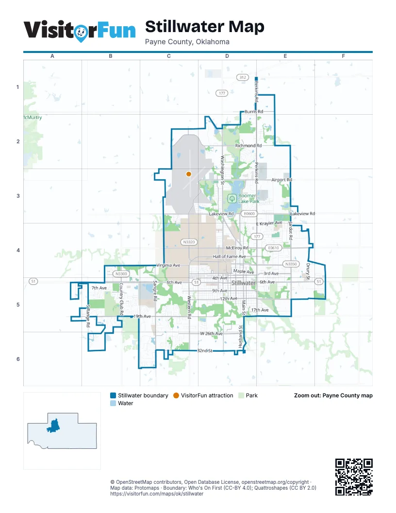
Street index of Stillwater
Each street on the sheet and the grid squares it crosses.
- West 6th AvenueA5, B5, C5, D5
- North Perkins RoadE1, E2, E3, E4
- North Washington StreetD2, D3, D4
- East 6th AvenueD5, E5, F5
- West Richmond RoadC2, D2
- South Perkins RoadE4, E5
- East Richmond RoadD2, E2
- North Jardot RoadE2, E3, E4
- South Main StreetD4, D5, D6
- South Western RoadC4, C5, C6
- West Lakeview RoadC3, D3
- East McElroy RoadD4, E4
- South Country Club RoadB4, B5
- West Hall of Fame AvenueC4, D4
- North Western RoadC2, C3, C4
- East 12th AvenueD5, E5
- East Lakeview RoadD3, E3
- West 12th AvenueB5, C5, D5
- West Airport RoadD3
- South Jardot RoadE4, E5
- East Airport RoadD3, E3
- South Duck StreetD4, D5
- North Boomer RoadD3, D4
- North Main StreetD4
- North Duck StreetD4
- East Hall of Fame AvenueD4, E4
- South Western AvenueC5
- North Country Club RoadB4
- West 19th AvenueA5, B5, C5, D5
- North Husband StreetD2, D3, D4
- South Sangre RoadC4, C5, C6
- West McElroy RoadC4, D4
- West 9th AvenueB5, C5, D5
- West 32nd StreetC6, D6
- West 26th AvenueC6, D6
- North Monroe StreetD3, D4
- West 4th AvenueB4, C5, D5
- South Washington StreetD4, D5, D6
- West 3rd AvenueB4, C4, D4
- East 3rd AvenueD4, E4, F4
- West University AvenueC4, D4
- West Virginia AvenueC4, D4
- South Range RoadB5, B6
- East Virginia AvenueD4, E4
- South Knoblock StreetD4, D5
- South Lewis StreetD4, D5
- South Hester StreetD4, D5
- East Burris RoadD1, E1
- West Farm RoadC4, D4
- North Hargis RoadC3, D3
- South Monroe StreetD4, D5
- East 19th AvenueD5, E5
- West Miller AvenueD4
- East 9th AvenueD5, E5
- East 18th AvenueD5, E5
- North Airport Industrial Access RoadC3, D3
- University CircleD4
- East Miller AvenueD4
- West Burris RoadD1
- WashingtonD4
- East 32nd StreetD6
- South Husband StreetD4, D5, D6
- West 8th AvenueB5, C5, D5
- West 7th AvenueB5, C5, D5
- West 10th AvenueB5, C5, D5
- West 11th AvenueB5, C5, D5
- South Lowry StreetD4, D5
- North Manning StreetE3, E4
- South Walnut StreetD4, D5, D6
- West Yellow Brick DriveC6
- West 5th AvenueB4, B5, C5, D5
- South West StreetD4, D5, D6
- North Knoblock StreetD2, D3, D4
- South Duncan StreetD4, D5
- East 4th AvenueE4, F4, D5, E5, F5
- East Krayler AvenueE3, D4, E4
- East Will Rogers DriveE4
- South Willis StreetC4, C5
- North Marine DriveE3
- South Kings StreetD4, D5
- South Ridge DriveC4, C5
- East 17th AvenueD5, E5
- West 22nd AvenueC5, D5
- West 24th AvenueC5, D5
- South Orchard StreetD4, D5
- South Burdick StreetE4, E5
- South Tanglewood CircleC5
- West Country Club DriveB5
- North Lincoln StreetD3, D4
- East Sunrise AvenueE4
- North Park DriveD3, E3
- South August StreetC4, C5
- North Willis StreetC4, D4
- South Stallard StreetE4, E5
- South Brush Creek RoadF4, F5
- West Deer Crossing DriveC6
- South Innovation Way DriveC5
- North Walnut StreetD4
- North Grandview StreetE3, E4
- Black Oak DriveC5, C6
- North Boomer Lake DriveD3
- North Hartford StreetE2, E3, E4
- North Garfield StreetD2, D3, D4
- South Jefferson StreetD4, D5
- North Skyline StreetE3, E4
- South Payne StreetE4, E5
- South McFarland StreetC4, D4, C5
- West Tyler AvenueC4, D4
- East Maple AvenueD4, E4
- East 15th AvenueD5, E5
- North Duncan StreetD2, D4
- West Sunset DriveC4, D4
- West 14th AvenueB5, D5
- North Benjamin StreetE3, E4
- North Glenwood DriveD3, D4
- South Ramsey StreetD4, D5
- North Hunters RidgeD2
- East Redbud DriveD4, E4
- South Chester StreetD5
- South Drury StreetE4, E5
- South Fox Ledge DriveC6
- North Crescent DriveD3, D4
- East 8th AvenueD5, E5
- South Pioneer StreetC4, C5, C6
- East Raintree DriveE5, F5
- North Sangre RoadC3, C4
- West Liberty AvenueD3
- East 7th AvenueD5, E5
- East 5th AvenueD5, E5
- West 13th AvenueD5
- South Stanley StreetD5
- East 14th AvenueD5, E5
- West Admiral AvenueC4, D4
- North Payne StreetE3, E4
- South Arrington DriveE4, E5
- North Star DriveD3, D4
- Dobi LaneC3, C4
- East Alcott AvenueE5
- Peaceable Acres RoadD2
- East Rogers DriveD2, E2
- East 16th AvenueD5, E5
- West Woodland Trails AvenueB6, C6
- North Burdick StreetE3, E4
- North Keller DriveD3
- Country Side DriveC5
- South Windsor DriveB4, B5
- South Adams StreetD5
- West Eskridge AvenueD4
- South Blakeley StreetD5
- South Gray StreetD5
- East Eastern AvenueE4
- East Willham DriveE4
- South McDonald StreetD5
- North Stallard StreetE4
- West Franklin LaneD4
- West 15th AvenueB5, C5, D5
- East 13th AvenueD5, E5
- South Pine StreetD5
- East Mercury AvenueE3
- West 18th AvenueB5, C5
- South Mansfield StreetB5
- South Doty StreetE4, E5
- West Arrowhead DriveC4, D4
- East Loveland DriveE3
- Falls DriveD2
- South Fern StreetD5
- East Copper Canyon AvenueD1, D2
- South August DriveC5, C6
- South Boulder Creek DriveB5
- South Ransom DriveE5
- West 23rd AvenueC5, D5
- West 27th AvenueC6
- South Oak Trail DriveB5
- Woodland DriveB5
- North Britton DriveD2
- East Brooke AvenueE4
- South Greystone StreetB5
- West Connell AvenueC4, D4
- North Ridge DriveC4
- North Ramsey StreetD3, D4
- East Crested Butte DriveE3
- West Wright DriveD3
- South Berry StreetE4, E5
- North Rogers DriveD2
- Wildwood DriveD3, D4
- South Fairfield DriveB5
- Wedgewood DriveE4
- West Woodlake DriveB6
- Lake DriveD3
- South Walking Trail DriveB5
- South Murphy StreetB5
- West Harned AvenueD3
- Arbor CircleC5
- Dryden CircleE4
- South Shumard DriveB5
- South Ashton DriveC5
- South Landry LaneB5
- North Mc Donald StreetD4
- South Monticello DriveD4
- North Donaldson StreetE4
- West Maple AvenueD4
- West Elm AvenueD4
- South Charles DriveB4, B5
- Hanson CircleE4
- North Jefferson StreetD3, D4
- Alcott DriveE5
- North Greenvale CircleD2
- East 10th AvenueD5, E5
- West Moore AvenueD4
- East Connell AvenueE4
- West Scott AvenueD4
- South Squires BoulevardB4, B5
- East 7th StreetE5
- West Osage DriveD3
- South Woodcrest DriveB5
- South Park DriveD4
- West Sherwood AvenueC4, D4
- West 29th AvenueC6, D6
- Shiloh Creek AvenueC5
- East Winter Park DriveE3
- South Pecan Hill StreetB5
- Mark CircleC3, C4
- South Quail Ridge StreetC6
- West Prescot DriveB5
- West 32nd AvenueB6, C6
- Oakridge DriveB5
- South Stoneybrook StreetB5
- East 11th AvenueD5
- East Elm StreetE4
- West Mathews AvenueD4
- West Aggie DriveB5
- East Elm AvenueD4, E4
- West Knapp AvenueD4
- East Echo Mountain DriveE3
- Athletic AvenueD4
- West Hillcrest AvenueD3
- Pinewood CircleE5
- West Lakeshore DriveD3
- North Emerald StreetD1, D2
- West 2nd AvenueB4
- South Benjamin StreetE4, E5
- South Springdale DriveB5
- South Hartford StreetE4, E5
- West Westbrook DriveC5
- Berry Creek StreetC5
- East Lauren LaneE3
- South Shalamar DriveC5
- West Trenton AvenueB5
- West Brentwood DriveD4
- McFarland AvenueD4
- North Young StreetE4
- West Yorkshire DriveC5
- State StreetD3
- West Bristol Road AvenueC5
- East Franklin AvenueE4
- South Celia LaneC5
- Hightower StreetE4
- South Copperfield StreetC5
- Knotts AvenueD3, E3
- South Berkshire DriveB5, C5
- North Cleveland StreetD4
- Fairway DriveB5
- South Lincoln StreetD4, D5
- West Cantwell AvenueD4
- West 25th AvenueC5, C6
- South Denver CourtE5
- West Ranch AvenueD2
- South Devon StreetC5
- East 2nd AvenueF4
- Timbercrest DriveE4
- West Cherokee AvenueD3
- West Bennett DriveD4
- West Hartwood AvenueD3
- North Dryden StreetE3, E4
- West 1st AvenueB4
- West Arapaho AvenueD3
- West Ute AvenueD2
- South Black Oak DriveC6
- West Brown AvenueD3
- East Linda AvenueE4
- Saddle Rock StreetC6
- East Topaz AvenueD2, E2
- South Fiddlers Hill StreetB5
- Villa DriveE4, E5
- South CStar BoulevardB4, B5
- Marie DriveD2
- North Denver StreetE4
- South Stoneridge DriveB5
- South Hidden Oaks DriveA5, B5
- Preston CircleC3, D3
- Summit CircleE4
- Mockingbird LaneF4, F5
- West Brooke AvenueD4
- East Moore AvenueE4
- West 30th AvenueC6
- West Loper AvenueB5
- East Ridgecrest AvenueE4
- South Woodridge Villiage RoadB5
- West Highpoint DriveD3
- Melrose DriveD4
Places on the map
- Babcock Park
- Barry Creek Office Complex
- Boomer Lake
- Boomer Lake Disc Golf Course
- Boomer Lake Park
- Boone Pickens Stadium
- Bradford Plaza
- Campus Corner
- Cedar Isle Lake
- Colvin Recreation Center
- Cottage Row
- Couch Park
- Couch Park Greenway
- Cowgirl Stadium
- Downtown Stillwater
- Fairlawn Cemetery
- Fountain Square
- Greiner Family Cross Country Course
- Hazen Lake
- Highland Park Elementary
- Home2 Suites by Hilton
- Hoyt Grove Park
- Intramural Fields
- Lakeshore Estates
- Lakeside Memorial Golf Course
- Lakeview Plaza
- Lakeview Pointe
- Myers Park
- North Intramural Fields
- Oklahoma State University
- Oknoname 11906 Reservoir
- Parkview Estates
- Sanborn Lake
- Sanborn Lake Park and Sports Complex
- Stillwater Golf And Country Club
- Stillwater High School
- Sunnybrook Christian Church
- The Links
- Turning Point Ranch
- Wedgewood Addition
© OpenStreetMap contributors, Open Database License, openstreetmap.org/copyright · Map data: Protomaps · Boundary: Who's On First (CC-BY 4.0); Quattroshapes (CC BY 2.0)















