

Oklahoma map
Sand Springs map
About 20,330 people live here (Census Bureau, 2024 estimate). The sheet's index lists 300 streets; West 61st Street South, Mannford Expressway and Old North Road cross the most grid squares. Also on it: Case Community Park, Shell Lake and Oknoname 143005 Reservoir.
Open the map (PDF, US Letter)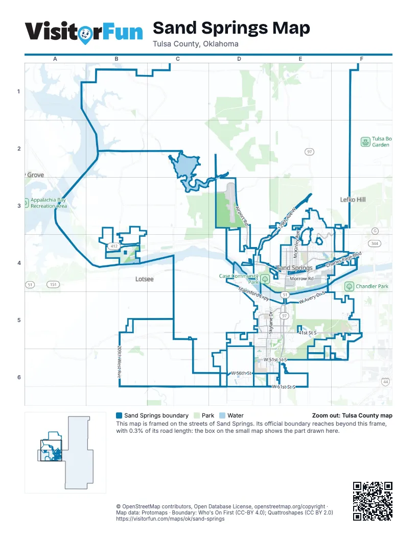
Street index of Sand Springs
Each street on the sheet and the grid squares it crosses.
- Sand Springs ExpresswayD4, E4, F4
- Keystone ExpresswayA3
- Marques Haynes HighwayE5, E6
- West 61st Street SouthB6, C6, D6, E6
- Mannford ExpresswayC4, D4, D5, E5
- North Wilson AvenueE4
- South Wilson AvenueE4
- West Morrow RoadE4
- Oklahoma Highway Patrol Lieutenant Pat Grimes Memorial BridgeE4, E5
- 42nd "Rainbow" Infantry Division Memorial HighwayE5
- United States Army Staff Sargeant Billie Hall Memorial HighwayA4
- Webco RoadD4
- West 41st Street SouthD5, E5, F5
- East Morrow RoadE4
- North McKinley AvenueE3, E4
- East Charles Page BoulevardE4, F4
- North Adams RoadE4
- East 41st Street SouthE5
- West 2nd Street NorthE4
- East 10th StreetE4
- East 2nd Street SouthE4
- South Adams RoadE4
- West Charles Page BoulevardF4
- Wekiwa RoadE4
- 129th Avenue WestE3, D4, E4
- West Wekiwa RoadB4, D4, E4
- West 51st Street SouthD6, E6, F6
- South 113th West AvenueE5, E6
- Shell Creek RoadC3, D3
- Skylane DriveE5, E6
- Old North RoadE3, F3, E4, F4
- Airport RoadD3
- Redbud DriveD5, D6
- North Main StreetE4
- North Garfield AvenueE4
- West 56th StreetD6, E6
- West 38th StreetD5, E5, F5
- Spruce DriveD5, D6
- South Nassau AvenueD5, D6
- East 10th Street SouthE4, F4
- North Roosevelt AvenueE4
- South 129th West AvenueD5
- East Sand Springs Park RoadE4
- South 81st West AvenueF4
- West 44th StreetD5, E5
- South Main StreetE4
- North Lincoln AvenueE4
- West Avery Drive SouthE4, E5
- Willow StreetD3, D4
- West 32nd StreetD5, E5
- West 10th StreetB4, E4
- South 73rd West AvenueF5
- West 41st StreetC5
- South 145th West AvenueD6
- 129th West AvenueD6
- East 12th StreetE4
- West Skyline DriveF6
- West 33rd StreetD5, E5, F5
- Angus DriveD5
- West Coyote TrailB5, C6
- South 137th Avenue WestD4, D5
- North 209th West AvenueB4
- West Alexander BoulevardE4
- East Broadway StreetE4
- West 1st StreetE4
- East 38th Street SouthE5
- North 81st West AvenueF3, F4
- North Sand Springs Road WestF3
- Park RoadE4
- Booker T. Washington AvenueE4
- West Edison Street NorthF3
- South 129th Avenue WestD6
- BroadwayE4
- East Bassett AvenueE5
- Old Towne RoadC2
- New Prue RoadB2
- West Cameron Street NorthF3
- South 209th West AvenueB4, B5, B6
- South Maple Drive WestD5
- West 35th StreetC5, D5, E5, F5
- South 112th West AvenueE5, E6
- South Linwood DriveE5, E6
- North Cleveland AvenueE4
- South Walnut Creek DriveE5, E6
- South 177th West AvenueC5
- North Franklin AvenueE4
- South Summit Boulevard WestE5
- West 40th StreetD5, E5, F5
- South Bermuda Avenue WestD5, D6
- Oak Ridge Drive EastE3
- South Rolling Oaks DriveF5
- North Grant AvenueE4
- West 5th Street SouthB4, E4
- West 46th StreetD5, E5
- East Pecan Street SouthE4
- North 73rd West AvenueF3
- Washington AvenueE4
- West 34th StreetD5, E5, F5
- Rawson RoadE5
- West 4th Street SouthD4, E4
- West 43rd Street SouthD5, E5
- West 7th StreetE4, F4
- East 11th StreetE4
- South 74th West AvenueF4, F5
- West 42nd Street SouthD5, E5
- South River City Park RoadD4
- Wilson RoadD2, D3
- Greentree WayD5
- West 32nd PlaceD5, E5
- 73rd West AvenueF1, F3
- West 6th StreetB4, E4
- Everett StreetE5
- Osage Ridge DriveE3
- 58th Street SouthD6
- North Birch AvenueE4
- West 55th StreetD6, E6
- Old North Road PlaceE3, E4
- North Greenview CircleE3
- Nassau AvenueD5, D6
- East 4th StreetE4
- Rustic RoadE5, E6
- Trinidad DriveD6
- South Redbud DriveD5, D6
- East 8th StreetE4
- East 7th StreetE4
- West Broadway StreetE4
- 60th Street SouthD6
- North Maple AvenueE4
- West 8th StreetE4
- Whispering Creek DriveE5
- Bahama DriveD5
- Bahama AvenueD5, D6
- West 12th StreetE4
- North Oak Ridge Drive EastE3, E4
- West 61st StreetC6
- North Cedar AvenueE4
- West 45th Street SouthD5, E5
- North Woodland DriveE4
- West 54th StreetD6, E6
- East 34th StreetE5
- Apple Creek DriveD4
- West 35th PlaceD5, E5
- West Parkway BlF4
- West 34th PlaceE5, F5
- Redbud PlaceD6
- 130th West AvenueD6
- Forest DriveE4
- West Parkway BoulevardF4
- Douglas AvenueE4
- North Lake DriveE4
- Magnolia DriveD5
- Euchee Creek BoulevardD4
- West 9th StreetE4
- South 193rd West AvenueB3
- South 155th West AvenueD6
- West Archer StreetB3
- Lakeside Ridge DriveE4
- Skylane PlaceE6
- West 40th PlaceD5, E5
- East 6th Street SouthE4
- South 89th West AvenueE5
- Silver Oak DriveF5
- West Weaver RoadD6
- West 11th StreetE4
- East 9th StreetE4
- North Fairway Circle EastE3, E4
- West 46th PlaceD5, E5
- Overholt DriveD6
- West 39th StreetD5, E5, F5
- South Woodland DriveE4
- South Bahama AvenueD6
- South 138th West AvenueD6
- 59th Street SouthD6
- Colony CircleE4
- South Teal Ridge DriveE5
- West 47th PlaceD5, E5
- East Fir DriveE4
- South 217th West AvenueB4
- East Holly AvenueE4
- South 149th West AvenueD6
- North Martin CircleE3
- Greenan DriveD5, D6
- West 21st StreetD4
- South 162nd West AvenueC6
- Wellston Park RoadD4
- Alexander BoulevardE4
- South 205th West AvenueB4
- West Hickory DriveB2
- West 39th Street SouthD5
- Barr DriveD6
- Peppermint DriveD6
- West 49th StreetF6
- West 36th StreetD5, F5
- South 164th West AvenueC6
- South Barr DriveD6
- Prattwood DriveD5, E5
- Colony DriveE4
- West 47th Street SouthD5, E5
- Renaissance DriveE4
- East 44th StreetE5
- South Nassau Avenue WestD5
- West 8th Street SouthB4
- South 74th West CourtF5
- West 31st StreetD5, E5
- West Gable Hills DriveF4
- West 27th Street SouthD5
- East Pecan StreetE4, F4
- Loop DriveD4
- Springtree LaneE5
- West 31st Street SouthE5
- 134th West AvenueD6
- East 4thE4
- South Everett AvenueE6
- East 5th StreetE4
- North Hickory AvenueE4
- East Forest Drive NorthE4
- South 105th West AvenueE6
- South 161st West AvenueC6
- Everett DriveE6
- Ecker LaneF1
- 204th West AvenueB4
- E0650 RoadB6, C6
- Broad StreetE4
- Elder AvenueE4
- West 26th Street SouthD5
- West 10th RoadE4
- South 153rd West AvenueD6
- West 59th StreetB6, E6
- North Willow StreetD3
- West 37th StreetD5
- Timber DriveD4
- 136th West AvenueD6
- East Saddle Rock Road SouthE5
- West 53rd PlaceD6, E6
- West 53rd StreetD6, E6
- South Christine Lane WestD5
- South Heather Avenue WestE5
- West 29th StreetD5
- East Easton PlaceE4
- 57th Street SouthD6
- South Magnolia DriveD5
- Prayer Mountain DriveB6
- Barbados AvenueD6
- South 75th West AvenueF5
- South Greenan Drive WestD6
- North Woodland PlaceE4
- South 72nd West AvenueF5
- South Walnut Creek PlaceE6
- West 60th Street NorthF1
- South Saddle Rock Road EastE5
- Jamaica DriveD6
- Nassau CircleD5, D6
- North Wild Mountain RoadF3
- West 14th StreetF4
- North Birch RoadE4
- South 204th West AvenueB4, B6
- Long StreetE4
- Howard StreetE5
- Tobago DriveD6
- Ivy LaneE4, F4
- West 45th Place SouthE5
- West 46th Street SouthE5
- Bermuda DriveD5
- South McKinley AvenueE6
- West 40th Street SouthD5
- West 57th PlaceE6
- Maple AvenueD5
- Walnut Creek DriveD4, E5
- South 145th Avenue WestD4
- South Bahama Avenue WestD5
- Cedar PlaceE4
- 132nd West AvenueD6
- Nassau DriveD5
- 52nd StreetD6, E6
- North Ash Avenue EastE4
- South 76th West AvenueF5
- South 123rd West AvenueD6
- West 53rd Street NorthF1
- West 31st PlaceE5
- North Pin Oak Drive EastE4
- Old North PlaceE4
- South Lake DriveE4
- Sunglo ParkwayD5
- South Summit CourtE5
- West 58th Street NorthF1
- North Industrial AvenueE4
- South CedarwoodE5
- Alliance BoulevardE4
- Rawson PlaceE5
- South Lincoln AvenueE4
- East 13th StreetE4
- East Seward AvenueE5
- AndrosD6
- West 50th PlaceD6
- Grenada AvenueD5, D6
- West 37th PlaceD5
- West 55th PlaceE6
- Everett PlaceE6
- East 32nd PlaceE5
- South 71st West AvenueF5
Places on the map
- Advance Auto Parts
- ALDI
- Angus Church
- Angus Valley Elementary School
- Angus Valley Park
- Ascension Saint John Clinic
- Atwoods
- Atwoods Plaza
- Auto Plus
- BancFirst
- Bank First
- BLOSS Sales & Rental
- Braum's
- Broadway Baptist Church
- Budget Inn
- Carl's Jr.
- Case Community Center
- Case Community Park
- Central School
- Chick-fil-A
- Chili's
- China Star
- Church That Matters
- City of Sand Springs City Hall
- Clyde Boyd Middle School
- Colton's Steak House & Grill
- Cox Cash Saver
- CVS Pharmacy
- Dollar General
- Dollar Tree
- Keystone Chevrolet
- Oknoname 143005 Reservoir
- Ray Brown Park
- Sand Springs Lake
- Sand Springs Lake Park
- Shell Lake
- The Shops at Adams Road
- Walmart Supercenter
- Webco Industries
- William R Pogue Municipal Airport
Next to Sand Springs
- Lefko Hill
- Lotsee
- Shady Grove
© OpenStreetMap contributors, Open Database License, openstreetmap.org/copyright · Map data: Protomaps · Boundary: Who's On First (CC-BY 4.0); Quattroshapes (CC BY 2.0)















