

Oregon map
Bend map
About 106,926 people live here (Census Bureau, 2024 estimate). The sheet's index lists 300 streets; Bend Parkway, Mount Washington Drive and Northeast 18th Street cross the most grid squares. Things to do inside the boundary: Deschutes Historical Museum, High Desert Food Trail and Puzzle Effect Bend.
Open the map (PDF, US Letter)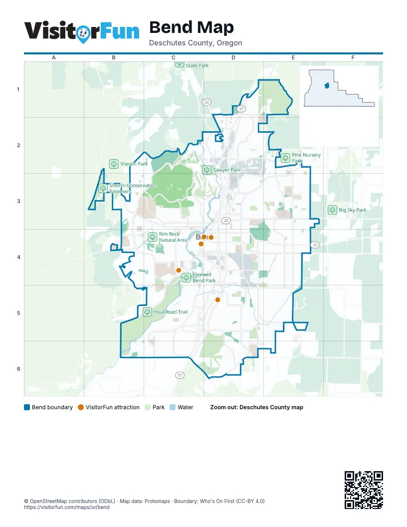
Street index of Bend
Each street on the sheet and the grid squares it crosses.
- Bend ParkwayD1, D2, D3, D4, C5, D5, C6
- Southeast Reed Market RoadD4, D5, E5
- Southeast 15th StreetD4, D5, D6
- Empire AvenueD2, E2
- Northeast Butler Market RoadE2, D3, E3
- Northeast 27th StreetE2, E3, E4
- Southwest Reed Market RoadC4, D4, C5
- Northeast 3rd StreetD2, D3, D4
- Southeast 3rd StreetD4, C5, D5
- Northeast Highway 20D4, E4
- Southeast 27th StreetE4, E5
- Highway 97D1, D2
- McKenzie-Bend HighwayD1, D2
- O.B. Riley RoadD2, D3
- The Dalles-California HighwayD1, C6
- Northeast Revere AvenueD3
- Northeast Greenwood AvenueD4
- Division StreetD3, D4, D5
- 27th StreetE4
- Northwest Revere AvenueD3
- Central Oregon HighwayE4
- Southeast Division StreetD4
- Mount Washington DriveC2, B3, C3, D3, B4, C4
- Northwest Shevlin Park RoadB3, C3
- Southwest Century DriveC4, B5, C5
- Cooley RoadD1, E1
- Northeast 18th StreetE1, D2, E2, D3
- Southeast Murphy RoadC5, D5
- Brookswood BoulevardC4, C5, C6
- Southwest Brookswood BoulevardC5, C6
- Northeast Neff RoadD3, E3
- Southwest Colorado AvenueC4
- Northeast 8th StreetD3, D4
- Northwest Newport AvenueC3, D3, D4
- Southeast Knott RoadD6
- Northwest Wall StreetD3, C4, D4
- Northeast Olney AvenueD3
- Powers RoadC5, D5
- Northwest Mount Washington DriveC3, D3
- Southwest Mount Washington DriveC4
- Northeast Penn AvenueD3
- Northwest Galveston AvenueC4
- Northwest Bond StreetD3, C4, D4
- Robal LaneD2
- Northwest Colorado AvenueC4, D4
- Northeast 15th StreetD4
- Northeast Division StreetD3
- Northwest Arizona AvenueC4, D4
- Southwest Murphy RoadC5
- Northwest Greenwood AvenueD4
- Southeast Scott StreetD4
- Deschutes Market RoadE2
- Northwest Olney AvenueD3
- Knott RoadD6
- Northeast Purcell BoulevardE2, E3, E4
- Northeast Boyd Acres RoadD1, D2, D3
- Brosterhous RoadD5, D6
- Northwest Summit DriveC3
- Bear Creek RoadD4, E4
- Northeast 4th StreetD3, D4
- Skyliners RoadB4, C4
- Southeast Parrell RoadD5, C6
- Southwest Simpson AvenueC4
- Northwest Crossing DriveC3, B4, C4
- Archie Briggs RoadC2, D2
- Northwest Portland AvenueC3, D3
- Eagle RoadE2, E3
- Northeast Wells Acres RoadD3, E3
- Northwest 12th StreetC3, C4
- Wilson AvenueD4
- Southwest Columbia StreetC4, D4
- Northwest Trenton AvenueC3
- Country Club DriveD5, D6
- Southwest Bond StreetC4, D4
- Northwest College WayC3
- Ferguson RoadD5, E5
- Southeast 9th StreetD4, D5
- Northwest Lemhi Pass DriveB3, C3, C4
- Northwest Awbrey RoadC3
- Pettigrew RoadE4, E5
- Northeast 10th StreetD3, D4
- Northeast 9th StreetD3, D4
- Northwest Skyline Ranch RoadB3, B4
- Northeast Franklin AvenueD4
- Britta StreetD2
- Northwest 14th StreetC3, C4
- Brinson BoulevardD2, D3, E3
- Northwest Riverside BoulevardC4
- Northeast Norton AvenueD3
- Southeast Caldera DriveD6, E6
- Southwest Industrial WayC4, D4
- Southeast 2nd StreetD4
- American LaneD5
- Lodgepole DriveC5, C6
- Parrell RoadD5
- Southeast Brosterhous RoadD5, D6
- Southwest China Hat RoadC6, D6
- Southwest Ponderosa StreetC6
- Northwest Franklin AvenueC4, D4
- Hunnell RoadD1, D2
- Beall DriveE3
- Southwest Metolius DriveC4, C5
- Southwest Badger RoadC5, D5
- Northeast Studio RoadD3
- Yeoman RoadE2
- Pinebrook BoulevardC5
- Southwest Wilson AvenueD4
- Northwest Regency StreetB3, C3
- Southwest Lodgepole DriveC5, C6
- Northwest 9th StreetC3
- Stevens RoadE5
- Northwest Tumalo AvenueC4
- Northwest Oregon AvenueD4
- Northwest Hawthorne AvenueD4
- Metolius DriveC4, B5, C5
- Northwest Crosby DriveB4
- Woodside RoadD6
- Southeast Old Murphy RoadC5, D5
- Southwest Pinebrook BoulevardC5
- Southwest Parrell RoadC6
- Skyline Ranch RoadB3
- Southwest Wall StreetC4
- Northwest Wild Rye CircleC2
- Northwest Fairway Heights DriveC2, C3, D3
- Southwest Green Lakes LoopB4, C4
- Northeast 2nd StreetD3, D4
- Northeast 6th StreetD3, D4
- Southwest Tam McArthur LoopB4, C4, B5
- Northeast 5th StreetD3, D4
- Southwest Broken Top DriveB4, C4
- Northwest Champion CircleB3, C3
- Mountain High LoopD6
- Southwest Hollygrape StreetC5
- Northwest Saginaw AvenueC3, D3
- Pilot Butte RoadD3, D4, E4
- Northwest Starview DriveC2, C3
- Southwest River Rim DriveB6, C6
- Northwest Farewell DriveC3
- Hunters CircleD1, D2
- High Desert LaneD2
- Nels Anderson RoadD2
- Mammoth DriveB5, C5
- Northwest Vicksburg AvenueC3, D3
- Northeast Providence DriveE3, E4
- Ranch Village DriveD1, D2
- Southwest Blakely RoadC4, C5
- Northwest High Lakes LoopB4, C4
- Northwest Hill StreetD3, D4
- Northwest Harriman StreetD3, D4
- Southeast Fargo LaneE4, E5
- Northeast Shepard RoadD3
- River Bluff TrailB5, C5
- Northwest Hartford AvenueC4
- Northwest Remarkable DriveC2, C3
- Mount Bachelor DriveC5
- Northwest Putnam RoadC2, C3
- Northeast Sierra DriveD2, E2
- Southeast Centennial StreetD4, D5
- Northeast Locksley DriveE3, E4
- Vogt RoadD2
- Airpark DriveE4
- Northeast 12th StreetD3, D4
- Ladera RoadE5
- Northeast 11th StreetD3, D4
- Northeast Tucson WayE3
- King Hezekiah WayD5, E5
- Southwest Mahogany StreetC5, C6
- Alderwood CircleC4, C5
- Southwest Chuckanut DriveC5, C6
- Northwest Lolo DriveB4, C4
- Southeast Geary DriveC5, D5, C6
- Northeast Jones RoadD3
- Jamison StreetD2
- Northwest 13th StreetC3, C4
- Northwest Columbia StreetC3, C4
- Northwest Flagline DriveC4
- Northwest Milwaukee AvenueC3, C4
- Northeast Quimby AvenueD3
- Southeast 5th StreetD4
- Southwest Granite DriveC5, C6
- Southwest Silver Lake BoulevardD4, C5, D5
- Northwest Albany AvenueC4
- Northeast 7th StreetD3, D4
- Southeast Westview DriveD5, E5
- Northwest Quincy AvenueC3
- Northwest Ogden AvenueC3
- Northwest Yosemite DriveC2
- Southeast Greenmont DriveD5, E5
- Northwest Horizon DriveC2, C3
- Rae RoadD5
- Sunshine WayB5, C5
- Liberty LaneD2
- Northwest Kingston AvenueC4
- Northwest John Fremont StreetB3, B4
- Northwest 1st StreetC3, D3
- Northeast 1st StreetD3, D4
- Benham RoadD5
- Desert Woods DriveD5, E5
- Northeast Emerson AvenueD4
- Northwest Shields DriveB3
- Blue Lake LoopC5
- Northwest Delaware AvenueC4, D4
- Klahani DriveD5
- Southwest Westridge AvenueC5
- Northwest 15th StreetC3, C4
- Northwest Marken StreetB3
- Northeast Lafayette AvenueD3
- Southwest Brookside WayB5, C5
- Southeast Ambassador DriveD5, D6
- Northwest McCready DriveB2, B3
- Northwest Iowa AvenueC3
- Southwest Amethyst StreetC6
- Northeast Stonebrook LoopE2, E3
- Northeast Daggett LaneE3
- Mountain High DrriveC6, D6
- Northwest Federal StreetC3, C4
- Northwest Clearwater DriveB4
- Willow Creek LoopD6
- Morningstar DriveD2, E2
- Northwest Hidden Ridge DriveC2, C3
- Northwest Constellation DriveC2, C3
- Snowbrush DriveC5
- Eastview DriveD2
- North SuntreeD4
- Layton AvenueD2, D3
- Northwest Skyliner Summit LoopC4
- Northwest Perspective DriveC2, C3
- Southwest Knoll AvenueC4
- Northwest West Hills AvenueC3
- Northwest Elgin AvenueC4
- Thomas DriveE4
- Northwest Harmon BoulevardC3, C4
- Northwest Promontory DriveC3
- Northeast Seward AvenueD3
- Northeast Hawthorne AvenueD4
- Northwest Colonial DriveC2, C3
- McClellan RoadC5
- Northwest Three Sisters DriveC3
- Northwest 6th StreetC3, C4
- Southeast Fairfield DriveD5
- Northwest Juniper StreetC3
- Southeast Grand Targhee DriveC6
- Northwest Redfield CircleC3
- Northwest Greenleaf WayC2
- Southeast Roosevelt AvenueD4
- Northwest Summerhill DriveB3
- Southeast Bridgeford BoulevardD4
- Southeast Woodland BoulevardD4
- Southeast 4th StreetD4
- Southwest Chandler AvenueC4
- Southwest Poplar StreetC6
- Northwest Lava RoadD4
- Northwest Park Commons DriveB3
- Northeast Ross RoadD3
- Northeast Irving AvenueD4
- Northwest Georgia AvenueC4, D4
- Bachelor View DriveB5, B6
- Lolo RoadB4
- Northeast Ocker DriveE3
- Northwest Shevlin Meadow DriveB3
- Northwest Drouillard AvenueC4
- Desert Sage StreetE2
- Stonewood DrriveD2, E2
- Southeast Craven RoadE4
- Brentwood AvenueD5
- Southeast Sweet Pea DriveD5, D6
- Southwest Rock Bluff LaneC5
- Northeast Hidden Valley DriveD3
- Northwest Stonepine DriveC3
- Keyte RoadE3
- Northwest Broadway StreetC4
- Brightwater DriveE2
- Northwest Glassow DriveC3
- Northeast Kearney AvenueD4
- Northeast Lotus DriveE3
- Northeast Lynda LaneE3
- Northwest Overlook DriveC2, C3
- Softtail LoopE4
- Northwest Florida AvenueC4, D4
- Northwest Discovery Park DriveB3, B4
- Northwest Fort Clatsop StreetB3, B4
- Northwest 2nd StreetC3, D3
- Southeast Larkspur LoopD5
- Northwest Jacksonville AvenueC4
- Northeast Jackson AvenueE3
- Majestic LoopD2
- Northwest Polarstar AvenueB3
- Mount Shasta DriveB3
- Northeast Meadow LaneD3, E3
- Golden Meadow LoopB6
- Southeast Daly Estates DriveE4, E5
- Northwest Fresno AvenueC4
- Northwest Monterey Pines DriveC3
- Southeast Shadowood DriveE4, E5
- Northwest Davenport AvenueC4
- Northwest Melville DriveB3
- Northwest Nightfall CircleC3
- Boulderfield AvenueD2
- Northwest Cumberland AvenueC4
- Marsh Orchid DriveE2
Things to do on the Bend map
Places on the map
- Al Moody Park
- All Seasons RV & Marine
- Alpenglow Community Park
- Archie Briggs Canyon Natural Area
- Bear Creek Elementary School
- Bend Center
- Bend Downtown Post Office
- Bend Factory Outlet Stores
- Bend Golf & Country Club
- Bend historic districts
- Bend River Promenade
- Bend RV Resort
- BLS Open Space
- Caldera High School
- Cascade Village
- Century Park
- Discovery Park
- Drake Park
- Farewell Bend Park
- Forum
- Haul Road Trail
- Larkspur Natural Area
- Mirror Pond
- Old Back Nine Golf Club
- Old Mill District
- Old Town Historic District
- Pilot Butte Airport
- Pilot Butte Cemetery
- Pilot Butte State Scenic Viewpoint
- Rim Rock Natural Area
- River's Edge Golf Course
- Riverbend Park
- Sawyer Park
- Shevlin Conservation Easement
- St. Charles Bend
- Summit Health
- Summit High School
- Sun Outdoors Bend
- The Pavilion
- Town Square Mall
© OpenStreetMap contributors, Open Database License, openstreetmap.org/copyright · Map data: Protomaps · Boundary: Who's On First (CC-BY 4.0); Quattroshapes (CC BY 2.0)















