

Oregon map
Columbia County map
About 54,063 people live here (Census Bureau, 2024 estimate). The sheet's index lists 300 streets; Lower Columbia River Highway, Scappoose Vernonia Highway and Keasey Road cross the most grid squares. Also on it: Sauvie Island Wildlife Area, Aaron's Lake and Carr Slough.
Open the map (PDF, US Letter)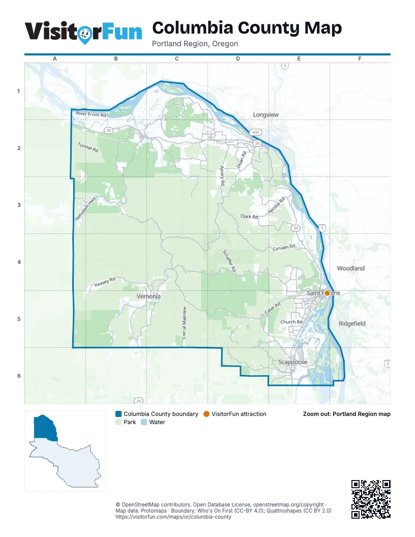
Maps inside Columbia County
1 map inside, from the street map of Columbia County down.
Street index of Columbia County
Each street on the sheet and the grid squares it crosses.
- Lower Columbia River HighwayA2, B2, C2, D2, E2, E3, E4, E5, E6
- Scappoose Vernonia HighwayC4, C5, D5, E5, E6
- Apiary RoadD2, D3, C4, D4
- Nehalem Highway NorthB3, C3, C4
- Beaver Falls RoadC1, B2, C2
- Old Rainier RoadD2
- Nehalem Highway SouthB5, B6
- Lost Creek RoadC2, D2
- Larson RoadD2
- Wonderly RoadD2
- Timber Road EastB5
- Northeast Crown Zellerbach RoadE6
- Bridge StreetB5, C5
- Rose AvenueB5
- West B StreetD2
- North Mist DriveC4, C5
- Sunset HighwayA6
- East Bridge StreetC5
- Lewis and Clark BridgeD2
- East B StreetD2, E2
- Mist DriveC5
- Oregon WayD2
- Columbia River HighwayD2, E6
- Northwest Saint Helens RoadE6
- Northwest Sunset HighwayA6
- Oregon Route 47B2, B3
- Fern Hill RoadD2, D3
- Nehalem HighwayA3, B3
- Timber RoadB5, B6
- Old Portland RoadE5
- Cater RoadD5, E5
- Mist-Clatskanie HighwayB2
- Sykes RoadE5
- Columbia BoulevardE5
- Heath RoadD2
- Gable RoadE5
- Saint Helens StreetE5
- South 1st StreetE5
- West 7th StreetD2
- Pittsburg RoadC4, D4, E4, E5
- Swedetown RoadC2, C3
- Keasey RoadB4, C4, A5, B5, C5
- Dutch Canyon RoadD5, D6, E6
- Neer City RoadD2, E2, E3
- Meissner RoadD3, D4
- Dike RoadA1, D2, E4, E6
- Canaan RoadD4, E4
- Alston Mayger RoadC1, D1, D2
- Nicolai RoadD3, E3
- Pisgah Home RoadD5, E5, D6
- Tide Creek RoadD3, E3
- Northwest Reeder RoadE5, F5, F6
- Conyers Creek RoadB2
- Walker RoadD3, D5
- Smith RoadE4
- Stewart Creek RoadC1, C2
- Fishhawk RoadA2, A3, B3
- Northwest Sauvie Island RoadE6
- Olson RoadC2, E4
- North Honeyman RoadE5, E6
- Cedar Grove RoadC2
- Delena Mayger RoadC1, C2
- Quincy Mayger RoadC1
- Pebble Creek RoadC5
- East Honeyman RoadE5, E6
- McDonald RoadB5, C5
- Debast RoadD2
- Commerce DriveE6
- Doan RoadD2
- Church RoadE5
- Stoney Point RoadC4, C5
- Beaver Springs RoadD2, D3
- Southwest Callahan RoadE6
- East Columbia AvenueE6
- Holaday RoadD5, D6, E6
- Ilmari RoadC1
- JP West RoadE6
- Mountain View RoadC2, E6
- Hazen RoadE5
- Hankey RoadE4, E5
- Gensman RoadE4
- Robinette RoadE4, E5
- Dart Creek RoadE4
- Bennett RoadE5
- Millard RoadE5
- Beaver Homes RoadD3, E3
- West Lane RoadE6
- Atkins RoadC2, D2
- Parkdale RoadD2
- Pellham Hill RoadD2
- Warren RoadC2, D2
- Slavens RoadE5
- Mayger RoadC1
- Wikstrom RoadE5, E6
- Mosier RoadC2, D2
- Nicolai Cutoff RoadE3
- Palm Hill RoadB2
- Bachelor Flat RoadE5
- Southwest Old Portland RoadE6
- Fullerton RoadE5
- Brownlee RoadD3, E3
- Berg RoadE5
- Townsend RoadD2
- South Morse RoadE5
- Southwest 4th StreetB2, E6
- South Bachelor Flat RoadE5
- Southwest Em Watts RoadE6
- Cowlitz StreetE5
- Southeast 6th StreetB2, E6
- Milton WayE5
- Southwest Dutch Canyon RoadE6
- West StreetE4, E5
- North Vernonia RoadE5
- Siercks RoadE5
- Johnson's Landing RoadE6
- East Kappler RoadE5
- West A StreetD2
- West Kappler RoadE5
- Maple StreetE3, B5, C5, E5
- Southeast 2nd StreetB2, E6
- Meserve RoadD2
- Saulser RoadE5
- Southeast 4th StreetB2, E6
- Tarbell RoadE5
- Washington WayD2
- Southeast Elm StreetE6
- Northeast 5th StreetB2, C2, E6
- Northwest 5th StreetB2, E6
- Plymouth StreetE5
- Wyeth StreetE5
- South McNulty WayE5
- Ferncrest DriveD2
- South 12th StreetE5
- Rabinsky RoadD6
- State AvenueC5
- Oregon StreetE4, E5
- Southwest Keyes RoadE6
- South Nehalem StreetB2
- South 4th StreetE5
- Bel Air DriveB2
- South 8th StreetE5
- South 18th StreetE5
- Firlock Park BoulevardE5
- Childs RoadE5
- North Morse RoadE5
- South 15th StreetE5
- Ross RoadE5
- South 7th StreetE5
- Moore RoadE6
- Graham RoadE2
- Sunset BoulevardE5
- Port AvenueE5
- Marracci RoadE5
- Alston RoadD2
- Southwest Bel Air DriveB2
- North 12th StreetE4, E5
- Deer Island RoadE4, E5
- High School RoadB2
- North 6th StreetE4, E5
- North 11th StreetE4, E5
- Skeans RoadD2
- East Division RoadE5
- Southeast High School WayE6
- North 18th StreetE5
- Achilles RoadE5
- East E StreetD2, E2
- North 16th StreetE5
- West 4th StreetD2
- Matzen StreetE5
- Havlik DriveE6
- Summit View DriveE5
- East 5th StreetD2
- North 15th StreetE5
- River StreetB5, E5
- Firlok Park StreetE5
- North 1st StreetE4, E5
- Rock Crest StreetD2
- South Division RoadE5
- Southwest Sequoia StreetE6
- Mill StreetD2, E5
- North Nehalem StreetB2
- South Vernonia RoadE5
- Southwest Elizabeth Matilda Watts RoadE6
- Frederick StreetE6
- East 1st StreetD2
- McNulty WayE5
- East 10th StreetD2, E2
- Camp 10 RoadC4
- South River StreetE5
- Northeast Van StreetC2
- East F StreetD2, E2
- Veterans WayD2
- Enterprise RoadB3, C3, C4, D4
- Crooked Creek MainlineB4, C4
- Janshaw RoadD4
- Tunnel RoadA2, B2
- Bacona-Pisgah Home RoadC5, D5, D6
- River Front RoadA1, B1
- Kauppi MainlineA4, B4
- Erickson Dike RoadB1, C1, B2
- Airstrip RoadC3, C4
- Corral MainlineC5
- Shepard RoadC2
- Colvin RoadA2, B2
- Schaffer RoadD4
- Lindberg RoadC2, E2
- Rupert RoadC3, D3, C4, D4
- Goat Ranch RoadC3
- Burn RoadB3, B4
- McKee MainlineC5
- Marshland RoadB2
- Deep Creek RoadA3, B3, B4
- Glahn MainlineC5
- Lentz RoadD2, D3
- Pisgah Lookout RoadD5
- Coates MainlineB4, C4
- Joe Flora RoadB2, B3
- Elk Creek RoadD2
- Clatskanie Heights RoadB2, C2
- Midland District RoadB1, B2
- Karth RoadD4
- Barnhardt MainlineB3
- Carver RoadA1, A2, B2
- Alder Grove RoadC2
- Scoutlake RoadC2
- Brooks RoadD5, E5
- Clark RoadD3
- South Canaan RoadD4
- McDermott RoadD4, E4
- Anliker RoadD3, D4
- West Ridge RoadB4, B5
- Hawkins RoadC5, D5
- Little Jack Falls RoadE2
- Hogan Ranch RoadE5
- Collins RoadB1, C1, B2
- Beaver Dike RoadC1, B2, C2
- Boozer RoadD5
- Van Natta RoadC3, D3
- Otto Miller RoadD6
- Hermo RoadC1
- Northwest Bacona RoadC5, C6
- Mist Logging RoadB3
- Wilark RoadD4, D5
- Barker RoadD3
- Nick Thomas RoadE3
- Gunners Lake MainlineD5
- Webb District RoadB1, B2
- Dowd RoadD5, E5
- O Black MainlineC4
- Stone RoadE5
- Coon Creek RoadC5
- Island RoadE4
- Alder Creek RoadD5
- Woodson RoadB1, B2
- Rutter RoadC1, C2
- Whitney RoadD3
- Cedar Creek RoadD5
- Haven Acres RoadB2, C2
- Highland RoadE3
- Kerry RoadA2
- Northwest Ej Smith RoadE6
- Cook Creek RoadC4
- Chapman Grange RoadD5
- Orr RoadE3
- Collins Road 1B1, C1
- Brinn RoadE4, E5
- Noakes RoadB5
- Blackford RoadC1
- Defrates RoadE3
- Gunners Lakes MnlnC5, D5
- Pinkney RoadD4
- Butterfield RoadE4
- Jones RoadE3
- Airport RoadB5, E6
- Gilmore RoadE6
- Lewis RoadB1, D2
- Neverstill RoadA3
- 6th StreetE4
- Hammond RoadD2, D3
- Gregory RoadD3
- Bishop Creek RoadD3, D4
- Kingsley RoadD5
- Kallunki RoadC1
- Maplecrest RoadE3
- Peterson RoadB5
- Raymond Creek RoadE6
- Hutchinson RoadD2, D3
- Trojan Access RoadE3
- Palm Creek RoadC2
- Holbrook RoadD3
- Collins Road 2B1
- Pioneer RoadE5
- Neer City Cemetery RoadE3
- Dahlgren RoadE5, E6
- Chapman RoadD5
- Clear Creek RoadB5
- Hazel Grove RoadC2
- Bishop RoadE3
- Cedar Grove DriveC2
- Merrill Creek RoadE4
Things to do on the Columbia County map
Places on the map
- Aaron's Lake
- Carr Slough
- Clatskanie
- Collins Beach
- Columbia City
- Columbia County Fairgrounds
- Cooper Island
- Cottonwood Lake
- Crane Lake
- Crane Slough
- Cunningham Lake
- Cunningham Slough
- Dalton Lake Recreation Area
- Deer Island Plant
- Dibblees Beach
- Henrici Lake
- Jones Beach
- Kerry Island
- Liberty Hill Camas Bluff
- Lord Island
- Malarky Lake
- McNary Lake
- Oak Ridge Lake
- Prescott Beach County Park
- Racetrack Lake
- Rainier
- Rainier Schools
- Ray's Lake
- Reeder Beach
- Saint Helens
- Santosh Pit
- Sauvie Island Wildlife Area
- Scaponia Park
- Scappoose
- Scappoose Bay
- Steelman Lake
- Sturgeon Lake
- The Garden Store
- Trojan Park
- Vernonia
Next to Columbia County
- Kelso
- Longview
- Ridgefield
- Woodland
© OpenStreetMap contributors, Open Database License, openstreetmap.org/copyright · Map data: Protomaps · Boundary: Who's On First (CC-BY 4.0); Quattroshapes (CC BY 2.0)















