

Oregon map
Corvallis map
About 61,993 people live here (Census Bureau, 2024 estimate). The sheet's index lists 300 streets; Southwest Philomath Boulevard, Northwest 29th Street and Northwest Walnut Boulevard cross the most grid squares. Also on it: Avery-Helm Historic District, Corvallis Country Club and Avery City Park.
Open the map (PDF, US Letter)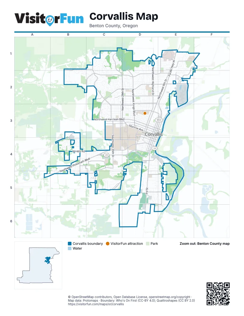
Street index of Corvallis
Each street on the sheet and the grid squares it crosses.
- Southwest Philomath BoulevardB4, C4, D4, A5, B5
- Northwest Walnut BoulevardB2, C2, D2, E2
- Northwest Circle BoulevardC2, D2, E2, C3
- Northwest 9th StreetE1, D2, E2, D3
- Northwest Harrison BoulevardC3, D3, E3
- Pacific Highway WestE1, E2, E3
- Northwest Van Buren AvenueC3, D3, E3
- 3rd StreetD4, D5, D6
- Northeast Circle BoulevardE2
- Northwest 3rd StreetD3, E3
- Northwest 4th StreetD3, E3
- Southwest 53rd StreetB4, B5
- Northwest 53rd StreetB3, B4
- Southwest 4th StreetD3, D4
- Southwest 3rd StreetD3, D4
- Northeast Walnut BoulevardE2
- Corvallis-Newport HighwayD4
- Northwest 2nd StreetD3, E3
- Northeast 2nd StreetE3
- Albany-Corvallis HighwayE2
- Southwest Western BoulevardC4, D4
- Northwest Kings BoulevardD1, D2, D3
- Northwest Highland DriveD1, D2
- Northwest Grant AvenueD2, C3, D3
- Southwest Reservoir AvenueB3, B4
- Southwest 35th StreetC3, C4
- Monroe AvenueD3, E3
- Southwest Madison AvenueD3, E4
- Southwest 15th StreetD3, D4
- Southwest 5th StreetD3, D4
- Southwest 14th StreetD3, D4
- Northwest 35th AvenueC3
- Northwest 29th StreetC1, C2, D2, C3, D3
- Southwest Country Club DriveC4, A5, B5, C5
- Southwest Brooklane DriveD4, C5, D5
- Northwest Jackson AvenueC3, D3, E3
- Northwest Witham Hill DriveC2, C3
- Northwest Garfield AvenueC2, D2, E2
- West Hills RoadB4, C4
- Southwest 30th StreetC3, C4
- Northwest Ponderosa AvenueB1, C1, E1, B2
- Southwest 26th StreetD3, D4
- Southeast Crystal Lake DriveD4, E4, E5
- Northeast Conifer BoulevardE1, F1
- Northwest 10th StreetD2, D3
- Northwest Buchanan AvenueD3, E3
- Southeast Goodnight AvenueD5, E5
- Northwest 30th StreetC2, C3
- Southwest Washington WayC4, D4
- Southwest Research WayC4
- Southwest Jefferson AvenueD3, D4
- Southwest 49th StreetB4, C4, C5
- Northwest 5th StreetD3, E3
- Northeast Conser DriveE1, F1, E2
- Southwest Avery Park DriveD4
- Northwest Samaritan DriveE1
- Southeast Midvale DriveE5, E6
- Southwest Adams AvenueD3, D4
- Southeast Rivergreen AvenueD5, E6
- Southeast Alexander AvenueD5, E5
- Northwest Satinwood StreetE1, E2
- Northwest Glenridge DriveC1, C2
- Northwest 36th StreetC3
- Southwest 45th StreetC4, C5
- Northwest Elks DriveE1
- Southwest Technology LoopB4, C4
- Northeast Seavy AvenueE2
- Southwest 2nd StreetD3, D4
- Northeast Jack London StreetE2
- Southwest Goodnight AvenueD5
- Southwest 9th StreetD3, D4
- Crystal Lake DriveD4
- Northwest Arnold WayD3
- Southwest Avery AvenueD4
- Southwest Kara AvenueC5
- Southwest Sagebrush AvenueC4
- Northwest 13th StreetD1, D2, D3
- Northwest Tyler AvenueC3, D3, E3
- Northwest Elmwood DriveC2, D2
- Northwest 11th StreetD2, D3
- Northwest 27th StreetD2, D3
- Northwest Polk AvenueC3, D3, E3
- Northwest 23rd StreetD2, D3
- Northwest 17th StreetD2, D3
- Northwest 14th StreetD2, D3
- Northwest Fillmore AvenueC3, D3, E3
- Northwest Lincoln AvenueC3, D3
- Northwest Taylor AvenueC3, D3
- Northwest 12th StreetD2, D3
- Southwest Campus WayC3, D3
- Northwest Arrowood CircleC1
- Northwest Hayes AvenueC2, D2, E2
- Southwest Grand Oaks DriveB4
- Northwest 25th StreetD2, D3
- Southwest Jefferson WayC3, D3
- Northwest Dixon StreetD2, D3
- Northeast Waterworks StreetE2, E3
- Southwest 6th StreetD3, D4
- Southwest Hollyhock CircleC5
- Northwest 15th StreetD2, D3
- Northwest Roosevelt DriveC2, D2
- Northwest Maser DriveB2, C2
- Northwest 16th StreetD2, D3
- Northwest Fair Oaks DriveB2, C2
- Northeast Lancaster StreetE1, E2
- Northwest Beca AvenueD3
- Northwest Garryanna StreetD2
- Southeast Park AvenueD5, E5
- Southeast Shoreline DriveE5, D6, E6
- Northwest Oak AvenueD2, E2
- Northwest Honeysuckle DriveC1
- Southwest Washington AvenueD4
- Northwest 6th StreetD3
- Northwest 31st StreetC3
- Northwest Woodland DriveC2
- Southwest 11th StreetD3, D4
- Northwest 33rd StreetC3
- Southwest Herbert AvenueD6
- Northwest Rolling Green DriveD1, D2
- Northwest 26th StreetD2, D3
- Southwest Whiteside DriveC4, C5
- Northwest Boxwood DriveC1
- Southwest Pickford StreetD5
- Northwest Arthur AvenueC2, D2
- Southwest Fairhaven DriveC5
- Northwest 32nd StreetC3
- Northwest 34th StreetC3
- Northwest Cleveland AvenueD2
- Northwest Hillcrest DriveC2, C3
- Northeast Canterbury CircleE1, F1
- Southwest 7th StreetD3, D4
- Northwest 28th StreetD3
- Northwest 19th StreetD2, D3
- Southeast Hathaway DriveD5
- Northwest 21st StreetD3
- Northwest Tamarack DriveC1, C2
- Southeast Bayshore CircleD6, E6
- Northwest 18th StreetD3
- Southwest Wake Robin AvenueD5
- Northwest Orchard AvenueC3, D3
- Southwest Wolverine DriveC5
- Northwest Garryanna DriveD1, D2
- Southwest Agate AvenueC5
- Northwest Menlo DriveD2
- Northwest Mulkey AvenueC2, D2
- Southeast Bethel StreetD4, E4, D5
- Cemetary Main LoopC5
- Southwest Chintimini AvenueC5, D5
- Southeast Thompson StreetD5
- Southeast Summerfield DriveD5, E5
- Northwest Alta Vista DriveC2, C3
- Northwest Sequoia AvenueD2, E2
- Southwest Knollbrook AvenueC4, D4
- Northwest 35th StreetC3
- Northwest Arthur CircleD2
- Northeast Plymouth CircleE1
- Southwest 10th StreetD3, D4
- Northwest Silktassel DriveC1
- Northwest Maxine CircleD1, E1
- Northwest Sycamore AvenueD2, E2
- Southwest Roseberry StreetB5, C5
- Southwest Willamette AvenueC5
- Southwest Twin Oaks CircleD4
- Northwest Merrie DriveC3
- Northwest Witham DriveC3
- Northwest Forestgreen AvenueD2
- Southwest Allen StreetD4, D5
- Southwest 13th StreetD3, D4
- Northeast Dorchester WayE1, F1
- Southeast Ryan StreetE5
- Northwest Conifer BoulevardD1, E1
- Northeast Belvue StreetE2
- Northwest Maxine AvenueE1
- Northwest Glenwood DriveB2
- Northwest 7th StreetD3
- Southwest Cascade AvenueC5, D5
- Northwest Angelica DriveD1, D2
- Southwest Sunset DriveC4
- Southeast Richland AvenueD5, E5
- Northwest Fernwood CircleC2, C3
- Northwest McKinley DriveC2
- Northwest Royal Oaks DriveB1, B2
- Southwest 8th StreetD3, D4
- Northwest 8th StreetD3
- Southeast Viewmont AvenueD5, E5
- Northwest Maple AvenueD2
- Southeast Bridgeway AvenueD4, E4
- Northwest Spruce AvenueD2, E2
- Southeast Lilly AvenueD4, E4
- Northwest Stardown DriveB1, B2
- Northwest Coolidge WayD3
- Northwest Jameson DriveC2
- Northwest Division StreetD2
- Northwest Estaview CircleC2
- Southwest B AvenueD4
- Northwest Firwood DriveC2
- Southeast River Bend DriveD5
- Northwest Ashwood DriveC2, D2
- Northwest Johnson AvenueC3, D3
- Northwest Clarence CircleC3
- Northwest Anjni CircleD1, D2
- Northwest Princess StreetC1, C2
- Northwest Buttercup DriveC1
- Southwest Arbor Grove DriveB4
- Southwest Quiet Creek AvenueB4
- Northwest Kinderman DriveC2
- Northwest Romancier DriveB2, C2
- Northwest Crest DriveC2
- Northwest Norwood DriveC2
- Gold Rush CircleE1, E2
- Southeast Atwood AvenueD4, E4
- Northwest Lantana DriveC2
- Southwest 1st StreetE3, D4, E4
- Southwest Windflower DriveB4
- Northwest Goldfinch DriveC1
- Northeast Cambridge CircleE1
- Southwest Barley Hill DriveB4, B5
- Northwest Elizabeth DriveC3
- Northwest Duniway DriveC3
- Southwest Birdsong DriveC5
- Southwest Long AvenueC4
- Northwest 1st StreetE3
- Northwest Greeley AvenueC2, D2
- Northwest Skyline DriveB2
- Northwest Huckleberry DriveC1
- Northwest Estaview DriveC2
- Northeast White Horse CircleE2
- Southwest Morris AvenueC4, D4
- Southwest A AvenueD4
- Northwest Lance WayC2
- Southwest Dearmond DriveC5
- Southwest Deschutes StreetD5, D6
- Southwest Avery Park LaneD4
- Southeast Mayberry AvenueD4
- Southeast Chapman PlaceD4
- Northeast Four Acre PlaceE2
- Northwest Survista AvenueE1
- Southwest Hilltop DriveC4
- Southwest Leonard StreetD5
- Northwest Greenbriar PlaceC1
- Northwest Poppy DriveC1
- Southeast Bell AvenueD5, E5
- Northwest Shooting Star DriveC1, D1
- Northwest Queens AvenueC1, C2
- Northwest Sundance CircleD1, E1
- Southeast Villa DriveD5
- Century DriveD1, D2
- Southwest Hillview AvenueB4, C4
- Southwest Birdie DriveC4
- Titleist CircleC5
- Centerpointe DriveD5, E5
- Southwest Aster StreetB5, C5
- Southwest Fairmont DriveC5
- Northwest Linden AvenueE2
- Northwest 20th StreetD2, D3
- Northwest Torchcrest PlaceB1, B2
- Southwest Timber Ridge DriveB4
- Southwest Timian StreetC4
- Southeast Powell AvenueD5, E5
- Southwest Stanford StreetB4, B5
- Southwest Trellis CircleB4
- Northwest Dale DriveC2, C3
- Northwest Sunview DriveC2
- Southeast Sternwheeler DriveE5
- Northwest Walnut PlaceC2
- Northwest Snowberry PlaceD1
- Southwest C AvenueD4
- Northwest Live Oak PlaceC1
- Southwest Cherry AvenueB4
- Northwest Acacia DriveC1
- Southwest Waverly StreetB4, B5
- Oxford CircleE1
- Southwest 56th StreetB4
- Northwest Charlemagne PlaceD1
- Southwest 55th StreetB4, B5
- Southwest Hawkeye AvenueC5
- Southwest Blueberry DriveB4
- Southeast Everglade StreetE5
- Northeast Glacier WayE1, F1
- Southwest Hopkins AvenueD4
- Southwest Meadow Flower DriveB5
- Southwest Country Club PlaceC4
- Northeast Park CircleE1
- Southeast Crystal CircleE4, E5
- Northwest Bryant StreetE1, E2
- Northwest Hummingbird DriveC2
- Northwest Caliope DriveC3
- Southwest 72nd StreetA4, A5
- Southwest Cummings AvenueD4
- Northwest Fairlawn StreetE2
- Northwest University PlaceC2
- Southwest Butterfield DriveD5
- Northwest Stewart StreetE1, E2
- Southeast Bayou PlaceE6
- Southeast Seaport CircleE5
- Lavender CircleB2
- North StreetD2, E2
- Northwest Douglas AvenueC2
- Northwest Forest DriveC2
- Northwest Monterey DriveC1, C2
Places on the map
- Adams Elementary School
- Ashbrook Independent School
- Avery City Park
- Avery-Helm Historic District
- Benton County Law Library
- Brandis Natural Area
- Bruce Starker Arts Park & Natural Area
- Cemetary Main Loop
- Cheldelin Middle School
- Chepenafa Springs Park
- Circle 9 Shopping Center
- College Hill West Historic District
- Corvallis Country Club
- Corvallis High School
- Corvallis Market Center
- Corvallis Post Office
- Corvallis Station
- Dr. Martin Luther King Jr Park
- Dunawi Wetlands
- Forest Dell Natural Area
- Good Samaritan Regional Medical Center
- Kings Circle Shopping Center
- Linus Pauling Middle School
- McNary Field
- Oak Lawn Memorial Park
- Oregon State University
- Oregon State University Historic District
- Pak Mail
- Peavy Field
- Pioneer Natural Area
- Pioneer Park
- Porter Park
- POWER Buick GMC service
- Rene Moye Sports Complex
- Reser Stadium
- Sunset Shopping Center
- Timberhill Natural Area
- Timberhill Shopping Center
- Willamette Disc Golf
- Woodland Meadow Park
© OpenStreetMap contributors, Open Database License, openstreetmap.org/copyright · Map data: Protomaps · Boundary: Who's On First (CC-BY 4.0); Quattroshapes (CC BY 2.0)















