

Oregon map
Benton County map
About 98,899 people live here (Census Bureau, 2024 estimate). The sheet's index lists 300 streets; Corvallis-Newport Highway, Alsea Highway and Main Street cross the most grid squares. Things to do inside the boundary: Corvallis.
Open the map (PDF, US Letter)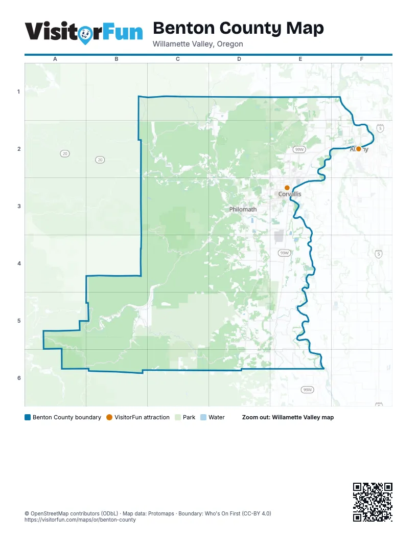
Maps inside Benton County
1 map inside, from the street map of Benton County down.
Street index of Benton County
Each street on the sheet and the grid squares it crosses.
- Corvallis-Newport HighwayB2, C2, D2, C3, D3, E3
- State Highway 99E4, E5, E6
- Albany-Corvallis HighwayE2, F2, E3
- Pacific Highway WestE1, E2, E3
- Northwest Springhill DriveE1, F1, F2
- Northwest Independence HighwayE1, E2
- Northwest Walnut BoulevardE2, D3, E3
- Southwest 53rd StreetD3
- Southwest Philomath BoulevardD3, E3
- 3rd StreetD3, E3
- Main StreetE2, D3, E5, E6
- Northwest Circle BoulevardE3
- Northwest Harrison BoulevardD3, E3
- Northwest 9th StreetE2, E3
- Applegate StreetD3
- Northwest Van Buren AvenueE3
- Territorial HighwayE6
- Highway 99WE3, E4
- Northeast Circle BoulevardE3
- Northwest 53rd StreetD3
- Northwest 3rd StreetE3
- Northwest 4th StreetE3
- Southwest 4th StreetE3
- Southwest 3rd StreetE3
- Northeast Walnut BoulevardE2, E3
- North 5th StreetE5
- South 15th StreetD3
- Northwest 2nd StreetE3
- South Pacific Highway WestE1
- Northeast 2nd StreetE3
- South 5th StreetE5, E6
- Corvallis RoadE1
- Alsea HighwayD3, C4, D4, A5, B5, C5
- Bellfountain RoadD3, D4, D5, D6
- Kings Valley HighwayD1, D2, D3
- Decker RoadC4, D4
- Summit HighwayB2, C2
- Tampico RoadE1, E2
- Maxfield Creek RoadD1
- West Hills RoadD3, E3
- Northwest Scenic DriveF1, F2
- Northwest Highland DriveE2, E3
- Greenberry RoadD4, E4
- Northeast Granger AvenueE2
- Northwest Ryals AvenueE2
- Southwest Western BoulevardE3
- Northwest Lewisburg AvenueE2
- Northwest Kings BoulevardE2, E3
- Southwest Reservoir AvenueD3
- Northwest North Albany RoadF2
- Chapel DriveD3
- Northwest Grant AvenueE3
- Southwest 35th StreetE3
- Northwest Gibson Hill RoadF2
- Southwest Plymouth DriveD3
- Monroe AvenueE3
- North 19th StreetD3
- Priest RoadD2
- Northeast Arnold AvenueE2
- Southwest Madison AvenueE3
- Southwest 15th StreetE3
- Southwest 5th StreetE3
- South 13th StreetD3
- South 19th StreetD3
- Southwest 14th StreetE3
- East Main StreetB5
- West Main StreetB5
- Northwest 35th AvenueE3
- Nashville RoadB2
- South Kings Valley HighwayD1
- South Fork RoadB5, C5, C6, D6
- Lobster Valley RoadA5, A6, B6
- Marys Peak RoadC3, C4
- Alsea-Deadwood HighwayB5, B6
- Old River RoadE5, E6
- Hoskins RoadC2, D2
- Alpine RoadD5, E5, D6
- Southwest Airport AvenueD3, E3, D4
- Dawson RoadD5, E5
- Beaver Creek RoadC4, D4
- Marys River RoadC1, C2
- Llewellyn RoadD4, E4
- Soap Creek RoadE1, D2, E2
- Fern RoadD3, D4
- Sulphur Springs RoadD2, E2
- Foster RoadD5
- Peterson RoadD4
- Coon RoadD6, E6
- Northeast Pettibone DriveE2
- Northwest Oak Creek DriveD2, D3
- Northwest 29th StreetE2, E3
- Northwest Oak Grove DriveF1, F2
- Southwest Brooklane DriveE3
- Mountain View DriveE2
- Southwest Country Club DriveD3, E3
- West Ingram Island RoadE5, E6
- Northeast Elliott CircleE2
- Camp Adair RoadE1
- Northwest Palestine AvenueE1, F1, F2
- Northeast Garden AvenueE2
- Northwest Jackson AvenueE3
- Northwest Crescent Valley DriveE2
- Stow Pit RoadE5
- Northwest Valley View DriveE2, F2
- Northeast Strawberry LaneE2, E3
- Northwest Arboretum RoadE2
- Hubbard RoadE5
- Northwest Witham Hill DriveE2, E3
- Concord DriveE2
- Schultz RoadE6
- Northeast Conifer BoulevardE2
- Northwest West Thornton Lake DriveF2
- Northwest Garfield AvenueE3
- Coffin Butte RoadE1
- Kyle RoadD5, D6
- Grange Hall RoadD3
- Northwest Crocker LaneF2
- Northwest Metge AvenueE2, F2
- North 9th StreetD3, E5, E6
- Marys River Estates RoadD3
- Southwest 30th StreetE3
- College StreetD3
- Northwest Ponderosa AvenueD2, E2
- Southwest 26th StreetE3
- Southeast Crystal Lake DriveE3
- Larson RoadD5
- Columbine DriveD3
- Wooded Knolls DriveD3
- Northwest 10th StreetE3
- Northeast North Nebergall LoopF2
- Northwest Buchanan AvenueE3
- Alpine Cutoff RoadD5, E5
- Northeast South Nebergall LoopF2
- Northwest Cardwell Hill DriveD3
- Northeast Seavy AvenueE2, E3
- Southwest 49th StreetD3, E3
- Southeast Goodnight AvenueE3
- Northwest 30th StreetE3
- Northwest Quarry RoadF2
- Northwest Lester AvenueE2
- Southeast Alexander AvenueE3
- Northwest Glenridge DriveE2
- Southwest Washington WayE3
- Southwest Research WayE3
- Southwest Jefferson AvenueE3
- Northeast Conser DriveE2
- Northwest 5th StreetE3
- Southwest Avery Park DriveE3
- Southwest 45th StreetE3
- Northwest Samaritan DriveE2
- Northwest Powers AvenueF2
- Barberry DriveE2
- Southeast Midvale DriveE3
- Northwest Satinwood StreetE2
- Southwest Adams AvenueE3
- Northwest Buena Vista RoadF1
- Southeast Rivergreen AvenueE3
- Preacher Creek RoadA6, B6
- Northwest Hickory StreetF2
- Northwest 36th StreetE3
- Northwest Elks DriveE2
- Southwest Technology LoopD3, E3
- Southwest 2nd StreetE3
- South 9th StreetD3, E6
- Orchard StreetE6
- Northeast Jack London StreetE2, E3
- Larkin RoadD5
- Northeast William R Carr AvenueE2
- Southwest Goodnight AvenueE3
- Airport RoadE3
- Southwest Sagebrush AvenueE3
- Southwest 9th StreetE3
- Crystal Lake DriveE3
- Northwest Arnold WayE3
- Southwest Avery AvenueE3
- North 13th StreetD3
- Southwest Kara AvenueD3, E3
- Vandenberg AvenueE2
- Noraton RoadE6
- South 1st StreetB5
- Buena Vista RoadF1
- Scenic Drive NorthwestF2
- Woods Creek RoadC3, D3
- BLM 10 (aka BLM 13-7-10)B4, C4
- South Mountain RoadB5, C5
- Harris RoadC3, D3
- Forest Road 3405C3
- Hull-Oakes RoadC5, D5
- Peak Creek RoadC4, C5
- Little Lobster Creek RoadB5
- McFarland RoadD5, E5
- Smith LoopE4
- Tum Tum RoadC2, C3
- Salmonberry RoadB5
- Bruce RoadD5, E5
- Miller RoadC5, D5, C6
- Alexander RoadC2, D2
- Luckiamute RoadC1, C2
- Southeast Kiger Island DriveE3, E4
- Sun Canyon RoadD1, D2
- Old Peak RoadC3, D3
- Oliver Creek RoadC5, D5
- Shingle Creek RoadC1, C2
- Prairie Mountain RoadB5, B6
- Green Peak RoadD5
- Cherry Creek RoadD6
- Lakeside DriveE4
- Finley Refuge RoadD4, E4
- Ray RoadB2, C2, C3
- Botkin RoadC4
- Forest Road 30B3, B4, C4
- Little Lobster RoadB6
- Norton Creek RoadC2
- Shot Pouch RoadB3, C3
- Ervin RoadD4
- Honey Grove RoadC5
- Blodgett RoadC2, C3
- Evergreen RoadD3
- Williams RoadD5, D6
- Northwest Grandview DriveF2, D3
- Winney RoadB5
- Nichols RoadD6
- Hayden RoadB5
- Hewett RoadD6
- Irish Bend RoadE5
- Reese Creek RoadD5
- Starr Creek RoadD4
- Gellatly WayD3
- East Ingram Island RoadE5, E6
- Echo Hills RoadD3
- Northwest 13th StreetE2, E3
- Eureka RoadE5
- Dodge Island RoadE6
- Fudge RoadB5
- Rifle Range RoadE1
- Orchard Tract RoadD5, D6
- Blakesley Creek RoadD2
- Northwest Tyler AvenueE3
- Northwest Elmwood DriveD3, E3
- Bundy RoadE5
- Cardwell Hill DriveD2
- Northwest 11th StreetE2, E3
- Northwest 27th StreetE2, E3
- Trout Creek RoadC5
- Northwest Polk AvenueE3
- Wiles RoadE1
- Pit RoadD1, D2
- Hurlburt RoadE4
- Price Creek RoadD1, D2
- Garrett LaneD3
- Northwest 23rd StreetE2, E3
- The GradeC4
- Neuman RoadD4
- Moss Rock DriveE2
- Northwest Chaparral DriveD3
- Camp Creek RoadA6
- Northwest Countryman CircleF2
- Northwest 17th StreetF2, E3
- Cecil LaneA5, B5
- Hewitt RoadD6, E6
- Bummer Creek RoadB5
- Carey Fox RoadC4
- Robison RoadE1
- Southeast Powells RoadE3
- Finley RoadE4
- Northwest 14th StreetE3
- Guerber LaneE4
- Henderson RoadD4
- Rickard RoadE6
- Northwest Fillmore AvenueE3
- Northwest Wynoochee DriveD3
- Southwest Herbert AvenueE3
- Lilly Hill RoadC2
- Northwest Jackson Creek DriveE2
- Northwest Lincoln AvenueE3
- Northwest Taylor AvenueE3
- Shady Oak DriveD5, E5, D6
- Iris CircleD3
- Northwest 12th StreetE2, E3
- Payne RoadE4
- Happy Hollow RoadB2, C2
- Southwest Campus WayE3
- Burgundy DriveE2
- Lower Hull-Oakes RoadC5, D5
- Northwest Arrowood CircleE2
- Northwest Hayes AvenueE3
- East Ingram Island PlaceE5, E6
- Hazel Glen RoadB6
- Haines RoadB5
- Southwest Grand Oaks DriveD3
- Rock Creek RoadC3, D3
- Ward RoadD1
- Military RoadE1
- Starr RoadD5, E5
- Northwest 25th StreetE2, E3
- Southwest Jefferson WayE3
- Northwest Mint AvenueE1, E2
- Henkle WayD3
- Daisy DriveD3
- Dykstra RoadD5
Things to do on the Benton County map
Places on the map
- Adair County Park
- Adair Disc Golf Course
- Adair Village
- Albany Golf Course
- Alsea Falls Recreation Site
- Alsea Quarry
- Anderson County Park
- Avery City Park
- Avery-Helm Historic District
- Bald Hill Farm
- Bald Hill Natural Area
- Beazell Memorial Forest
- Belloq Orchard
- Benton County Fairgrounds
- Brown Swamp
- Cabell Marsh
- Camp Alpine
- Chip Ross Park
- Coffin Butte Landfill
- Corvallis
- Corvallis Country Club
- Corvallis Forest
- Corvallis Watershed
- Crestmont Land Trust
- Dunn Research Forest
- E. E. Wilson Wildlife Area
- Fitton Green Natural Area
- Fort Hoskins Historic Park
- Herbert Open Space
- Jackson Frazier Wetland
- McDonald Research Forest
- McFadden Marsh
- Mill Hill Loop
- Monroe
- Oak Creek Preserve
- Owen's Farm Natural Area
- Philomath
- Starker Forest
- Thompson Lake
- William L. Finley National Wildlife Refuge
Next to Benton County
© OpenStreetMap contributors, Open Database License, openstreetmap.org/copyright · Map data: Protomaps · Boundary: Who's On First (CC-BY 4.0); Quattroshapes (CC BY 2.0)















