

Oregon map
Dallas map
About 17,911 people live here (Census Bureau, 2024 estimate). The sheet's index lists 300 streets; Southeast Uglow Avenue, Southeast Academy Street and West Ellendale Avenue cross the most grid squares. Also on it: Dallas City Park, Whitworth Sports Complex and Barberry Park.
Open the map (PDF, US Letter)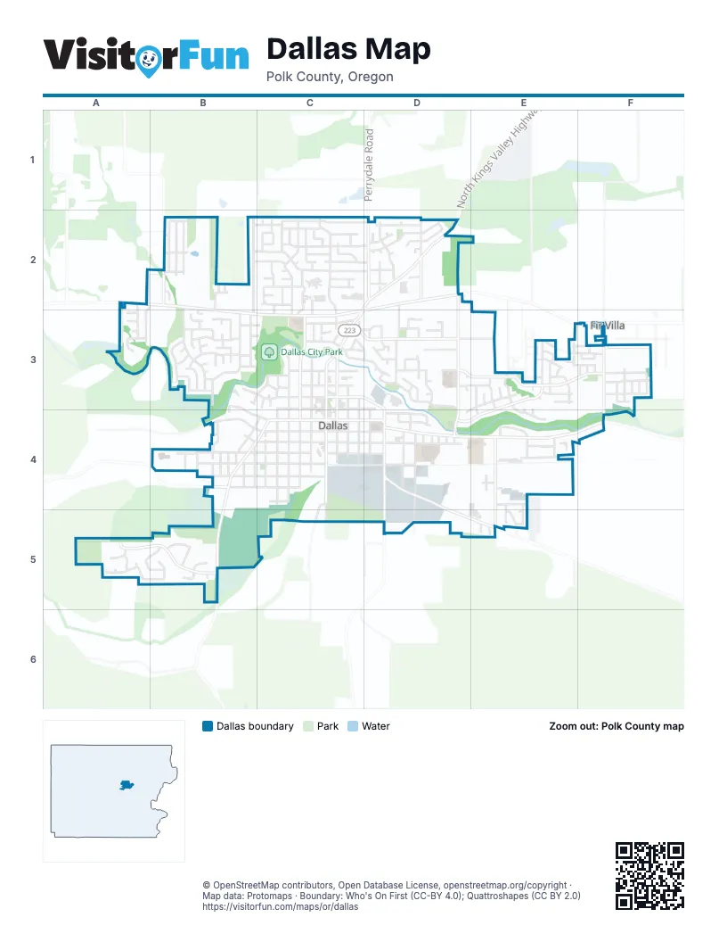
Street index of Dallas
Each street on the sheet and the grid squares it crosses.
- Main StreetC3, C4
- Southeast Uglow AvenueD2, D3, D4, D5
- Southeast Monmouth Cut OffD4, D5, E5
- Southeast Jefferson StreetC3, C4
- East Ellendale AvenueD2, C3
- Northeast Kings Valley HighwayC2, D2, C3
- Orchard DriveD2
- Southeast Washington StreetC4, D4
- Perrydale RoadD2
- Southeast Miller AvenueD4, E4, F4
- Southwest Fairview AvenueB4, C4, B5
- Southeast Lacreole DriveD2, D3, D4
- Southwest Washington StreetB3, B4, C4
- North Kings Valley HighwayD2
- Southeast Academy StreetC3, D3, E3, F3
- West Ellendale AvenueA2, B2, B3, C3
- Southeast Hankel StreetC3, D3, E3, F3
- Southwest Levens StreetC3, C4
- Southeast Barberry AvenueE3, D4, E4
- Southwest Bridlewood DriveA5, B5
- Southwest Mill StreetB3, C3
- Southwest Oakdale AvenueB4, C4
- Southeast Fir Villa RoadF3, F4
- Southeast Godsey RoadE4, E5
- Northeast Polk Station RoadD2
- Southeast Mill StreetC3, D3
- James Howe RoadB2
- Mistletoe RoadD5
- Southeast Orchard AvenueC3
- Southeast Walnut AvenueC3, D3
- Southwest Church StreetC3, C4, C5
- Southwest Hayter StreetC3, C4
- Northwest Denton AvenueB2, C2, D2
- Southwest Ash StreetB4, C4
- Southeast Ash StreetC4, D4
- Southwest Maple StreetB4, C4
- Southwest Birch StreetB4, C4
- Southwest Cherry StreetB4, C4
- Southwest Clay StreetB4, C4
- Northwest Reed LaneB2, C2, D2
- Southwest River DriveB3
- Northwest Jasper StreetC2, C3
- Northwest Hillcrest DriveC2, C3
- Northwest Douglas StreetB2, B3
- Southwest Ellis StreetC3, C4
- Southeast Holman AvenueD4, D5
- Southwest Wyatt StreetB2, B3
- Southwest Oakwood DriveA5, B5
- Northwest Fairhaven LaneC2, D2
- Northeast Fern AvenueD2
- Southeast Lyle StreetC3, C4
- Southwest Brandvold DriveB3, C3
- Southeast Hawthorne AvenueE3, E4
- Southeast Shelton StreetC3, C4
- Southwest Bryson StreetB3
- Northeast Dallas DriveD2
- Southeast Birch StreetD4
- East LoopE3
- Southeast Howe StreetD4
- Southeast Maple StreetC4, D4
- Southeast Clay StreetC4, D4
- Northwest Cascade Mountain DriveB2
- Northwest Coast Mountain DriveB2
- Southwest Stump StreetC4
- Southeast Jonathan AvenueE4
- Southwest Westwood DriveB3
- Northwest Tilgner LaneC2, C3
- Southwest Rainbow AvenueC3
- Southeast Azalea AvenueD4
- Northwest Crater Lake DriveB2
- Southwest Sequoia LaneB3
- Southeast Court StreetC3, D3
- Southwest Court StreetC3
- Northwest Heath StreetC2
- Southeast Rhododendron AvenueF3
- Southeast Cooper StreetE3
- Southeast Heather LaneE3, D4
- South Greenway DriveD3, E3
- Southwest Maplewood DriveA5, B5
- Southwest Augustus DriveB3
- Northeast Holiday AvenueD2
- Southeast Lewis StreetD3, D4
- Northwest Elderberry LaneC2, D2
- Southwest Brown StreetB4
- Southeast Magnolia AvenueF3
- Southwest Oregon AvenueB4, C4
- Southeast Juniper AvenueD4
- Northwest Ashley StreetC2
- Southwest Applegate Trail DriveA2, A3
- Northwest Ivy AvenueC2
- Northwest Brentwood AvenueC2
- Southwest Forestry LaneB3
- Southwest Academy StreetC3
- Southwest Walnut AvenueC3
- Southwest Linden LaneB3
- Southeast Pine StreetD3
- Northwest Robert StreetC2, C3
- Greenway DriveD3, E3
- Southeast Deschutes DriveD3
- Southeast Rosewood LaneD3
- Southwest Oregon Trail DriveA3
- Southeast Osoberry StreetE3
- Southeast Greenlee StreetE3, E4
- Southwest Eleventh StreetB4
- Southeast Stoneridge LaneF3
- Northwest Byers LaneB2, C2
- Southeast Fowler StreetE3
- Southeast Loganberry StreetE3
- Southeast Willow LaneE4
- Southeast Davis StreetD3
- Southeast Greenbriar AvenueD3, E3
- Southeast Cypress AvenueD3
- Southeast Salmonberry AvenueE3
- Southeast Ana AvenueE4
- Southwest Sheila StreetB3
- West LoopD3
- Southeast Cynthian DriveE3, E4
- Northwest Gavin DriveC2
- Northwest Woods LaneB2, B3
- Southeast Ironwood AvenueD3
- Northwest Aldridge AvenueB2, B3
- Northeast A StreetD2
- Northwest Howard LaneC2
- Southeast Virginia DriveE5
- Southwest Hill StreetB4
- Northwest Alameda StreetC2
- Southeast Cortland AvenueE4
- Northwest Kersey DriveC2
- Southeast Oak StreetC3
- Southeast Gregory DriveE4, E5
- Northeast Gerlinger LaneD2
- Southwest Oak StreetC3
- Northwest Hays DriveC2
- Southwest Laurelwood DriveB5
- Northeast Evergreen AvenueD2
- Northwest Card AvenueC2
- Southwest Natalie StreetB3
- Northeast Denton AvenueD2
- Northwest Bonanza AvenueC2
- South Main StreetC4, C5
- Ferron WayE3
- Northwest Foxglove StreetC2
- Southeast Dimick StreetC3, D3
- Southwest Boxwood LaneA5
- Evergreen DriveD3, E3
- Southeast Needham StreetC3, D3
- Southwest 10th StreetB4
- Southwest 9th StreetB4
- Southwest 13th StreetB4
- Southwest Marietta LaneB3
- Southeast Mifflin StreetD3
- Southeast Pine PlaceD3
- Southeast Blueberry StreetF3
- Southwest Robin Hood DriveC3
- Northwest Eve DriveC2
- Southeast Ray StreetE3
- Southwest Aspen LaneB3
- Southwest Elmwood DriveB5
- Southwest Crider StreetC3
- Southwest Allgood StreetC3
- Southeast Blackberry AvenueE3, F3
- East StreetE3
- Southwest Bell DriveB3
- Southwest Newton DriveB3
- Southeast Appleseed DriveE4
- Southwest Veazie StreetB3, C3
- Southeast Greening DriveE4
- Southeast Birchwood DriveC3, D3
- Northwest Columbia AvenueB2
- Southeast Saint Andrews LaneF3
- Southeast Lyncet LaneF3
- Southwest 11th StreetB4
- Southwest Harder AvenueC3
- Southwest Rose AvenueC4
- Southeast Gordon CourtE4, E5
- Southeast Thimbleberry AvenueE3
- Southwest Crestwood CourtB5
- Northeast Evergreen CourtD2
- Northeast Brentwood AvenueD2
- Northwest Rickreall Creek AvenueB2
- Southeast Mulberry AvenueE3, F3
- West StreetD3, E3
- Northwest Sunny DriveC2
- Southeast Alderson DriveD4
- Southwest Crestwood PlaceB5
- Romic LaneE3
- Southwest 14th StreetB4
- Southwest Hazel StreetA3
- Marlissa LaneE3
- Southwest Oregon Falls DriveA3
- Northwest Lange StreetC2, C3
- Southwest Alexander DriveB3
- Shyla LaneD3, E3
- Southeast Arthur StreetE4
- Southeast Huckleberry AvenueE3
- Southeast Stone StreetD3
- Southwest Clark DriveB3
- Northwest Eakin LaneC2
- Northwest Lalack StreetC2
- Southwest Park StreetB3
- Southwest Woodridge CourtA5
- Southwest View StreetC3
- Southeast Syron StreetD3
- Southwest Robb StreetC3
- Southwest Little John LaneB3
- Southwest Jasper StreetC3
- Southwest Ward DriveB3
- Northwest Beaver CourtB2
- Southeast Olive StreetE4
- Southeast Gleann Creek LaneF3
- Southeast Glendover LaneF3
- Southwest Fairlawn CourtB3
- Southeast Arrowwood AvenueF3
- Northwest Marshall StreetC2
- Southwest Nottingham LaneC3
- Northeast Bovard AvenueD2
- Southwest Kirklee DriveC3
- Southeast Guy LaneE3
- Southeast Wiens StreetF3
- Southeast Gooseberry StreetE3
- Southeast Snowberry AvenueE3
- Southwest 8th StreetB4
- Southwest Filbert LaneA3
- Southwest Sagebrush LaneA3
- Southeast Vandenbosch StreetE3
- Southeast Isenberg StreetF3
- Southeast Arizona StreetC3
- Southeast Muir LaneE3
- Northwest Broadmore CourtC2
- Southwest Marian CourtC3
- Southeast Camellia DriveE4
- Southeast Schmidt PlaceD3
- Southeast Stettler StreetD4
- Northwest Bryant CourtC2
- Southeast Joseph LaneE5
- Southeast Rowell StreetD3
- Southwest Collins DriveB2, B3
- Northeast Dogwood CourtD2
- Northwest Lalack PlaceC2
- Southeast Thomas CourtE5
- Northeast Gerlinger PlaceD2
- Southeast Davis CourtD3
- Southeast Mason StreetD4
- Northeast La Creole DriveD2
- Southwest Donald StreetC3
- Southwest Richard StreetB3
- Northwest Newcastle StreetB2
- Northwest Royal StreetB2
- Southeast Fenton StreetD4
- Southwest Glen StreetB3, C3
- Southwest Riverdale CourtB3
- Southwest Woodlawn CourtB3
- Southeast Tawney StreetF3
- Southwest Hatfield DriveB3
- Southeast Eubanks StreetD4
- Southeast Skys The Limit WayE4
- Northwest Liberty StreetC2
- Southeast Cedar AvenueD3
- Southeast Gleann Craig DriveE3, E4
- Southeast Seibert StreetE3
- Southwest Irick CourtB3
- Southeast Walnut CircleD3
- Southeast Brookside AvenueE4
- Southeast Heather CourtE3
- Southwest Canterbury CourtC3
- Northeast Kerns DriveD2
- Southeast Darcy DriveF3
- Southwest Kings PlaceB3
- Southwest Hunter StreetB3, B4
- Southwest Solomon CourtB3
- Southeast Jasmine LaneD3
- Southwest Alderwood CourtB5
- Southwest Pecan CourtA3
- Northwest Hillcrest LaneC2
- Southwest Chapman CourtB3
- Southeast Cottonwood LaneD3
- Northwest Ash Creek DriveB2
- Friesen CourtC2
- Southeast Greenbriar PlaceD3
- Southwest Valsetz AvenueB4
- Southeast Academy CourtE3
- Southeast Stone LaneD3
- South Church RoadC5
- Southeast Ironwood CourtD3
- Southeast Grant CourtE3, E4
- Southeast Shetterly DriveE3
- Southwest Oakwood CourtA5
- South StreetE3
- Southwest Locksley CourtC3
- Northwest Lalack CourtC2
- Southeast Nancy CourtE5
- Northeast Gerlinger CourtD2
- Northwest Perkins CourtC2
- Northeast Fern CourtD2
- Northwest Heath CourtC2
- Northeast Dallas CourtD2
- Southeast Marionberry StreetE3
- Southeast Walnut CourtD3
- Northwest Gavin CourtC2
- Northeast Paige DriveD2
Places on the map
- Abby's Legendary Pizza
- Barberry Park
- Best Western Dallas Inn & Suites
- Center Market
- Central Bark
- Dallas Alliance Church
- Dallas Aquatic Center
- Dallas Cemetery
- Dallas Church
- Dallas Church of Christ
- Dallas City Hall
- Dallas City Park
- Dallas Evangelical Church
- Dallas Foursquare Church
- Dallas High School
- Dallas Post Office
- Dallas Public Library
- Dallas Seventh-Day Adventist Church
- Dallas United Methodist Church
- Delbert Fredricks Memorial Park
- East Loop
- Evangelical Bible Church
- Ferron Way
- First Presbyterian Church
- Grace Baptist Church
- Grace Church
- Grocery Outlet
- House of His Presence
- John C. Barnard Park
- Kingdom Hall of Jehovah's Witnesses
- Kingsborough Park
- LaCreole Middle School
- LaCreole Sports Complex
- Roger Jordan Community Park
- Strader Field Baseball Complex
- The Grove Community Church
- Trinity Lutheran Church
- Valley Life
- Whitworth Elementary School
- Whitworth Sports Complex
Next to Dallas
- Fir Villa
© OpenStreetMap contributors, Open Database License, openstreetmap.org/copyright · Map data: Protomaps · Boundary: Who's On First (CC-BY 4.0); Quattroshapes (CC BY 2.0)















