

Oregon map
Polk County map
About 90,549 people live here (Census Bureau, 2024 estimate). The sheet's index lists 300 streets; Salmon River Highway, Main Street and South Kings Valley Highway cross the most grid squares. Things to do inside the boundary: Spirit Mountain Casino.
Open the map (PDF, US Letter)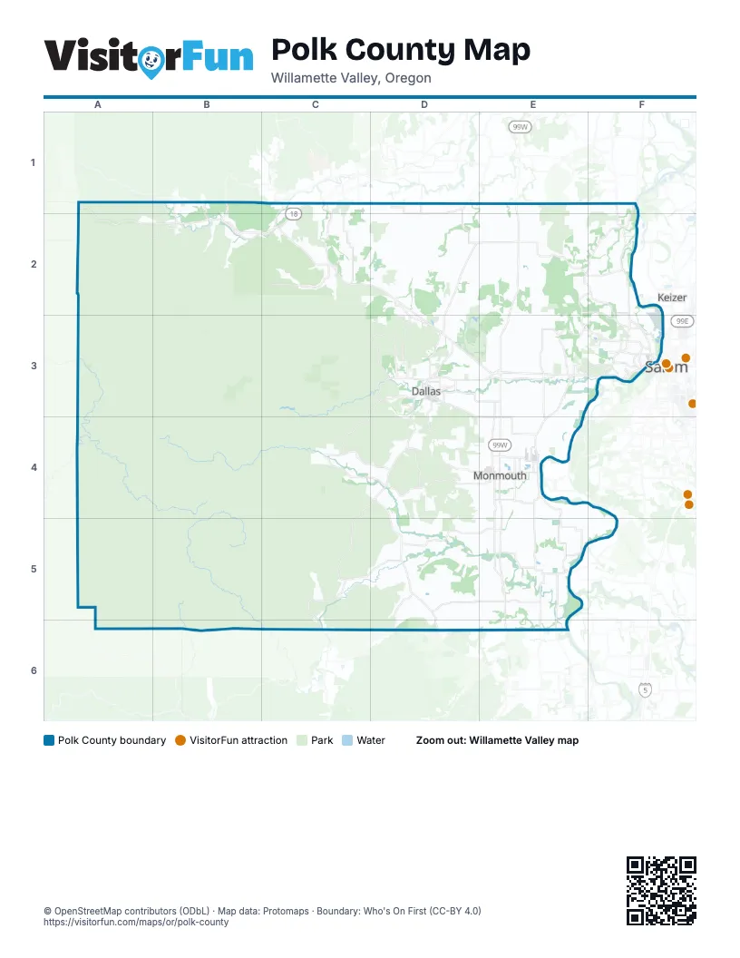
Maps inside Polk County
1 map inside, from the street map of Polk County down.
Street index of Polk County
Each street on the sheet and the grid squares it crosses.
- Salem-Willamina HighwayC2, D2, D3, E3
- Salmon River HighwayA1, C1, A2, B2, C2
- South Pacific Highway WestE3, E4, E5, E6
- Wallace Road NorthwestF1, F2, F3
- Perrydale RoadE1, D2, E2, D3
- North Pacific Highway WestE1, E2, E3
- Corvallis RoadE4, E5, E6
- Salem Dallas Highway NorthwestE3, F3
- Clow Corner RoadD3, D4, E4
- Independence HighwayE3, E4
- Rickreall RoadE3
- Yamhill River RoadB2, C2
- East Ellendale AvenueD3, E3
- Main StreetC1, C2, D3, E3, E5
- Ellendale RoadD3, E3
- Suver RoadE5
- Monmouth StreetE4
- North Main StreetC4, E4
- Southeast Uglow AvenueD3
- Hebo RoadB1, B2
- South Main StreetD3, E4
- Main Street EastE4
- Southeast Monmouth Cut OffD3
- Southeast Jefferson StreetD3
- Center Street BridgeF3
- Pacific Avenue NorthE4
- Northeast Kings Valley HighwayD3
- Orchard DriveD3
- Main Street SouthC1, C4
- Marion Street BridgeF3
- Southeast Washington StreetC1, D3
- Main Street SoutheastC1
- Pacific Avenue SouthE4
- Monmouth Independence HighwayE4
- River Road SouthE4
- Southeast Salem-Dayton HighwayF1
- River RoadE4
- Southwest Main StreetC1
- South Kings Valley HighwayD3, C4, D4, C5, C6
- Airlie RoadD4, D5, E5
- Monmouth HighwayD4, E4
- Orchard Heights Road NorthwestE3, F3
- Red Prairie RoadC1, C2
- Bethel RoadD2, E2
- Eola Drive NorthwestE3, F3
- Doaks Ferry Road NorthwestF3
- Falls City RoadC4, D4
- Sauerkraut RoadD5
- Glen Creek Road NorthwestF3
- Maxfield Creek RoadD5, D6
- Hoffman RoadE4
- North Kings Valley HighwayD3
- Hopewell Road NorthwestF1, F2
- Southeast Miller AvenueD3
- Edgewater Street NorthwestF3
- Grand Ronde Road NorthB1, B2
- Berry Creek RoadD5, D6
- Southwest Fairview AvenueD3
- Southeast Lacreole DriveD3
- Southwest Washington StreetD3
- North Gun Club RoadE4
- North Polk StreetE4
- Bridge StreetC4
- Falls City HighwayE4
- South Gun Club RoadE4
- West Main StreetE4
- Whitman Street SouthE4
- Tampico RoadD6
- Mill Creek RoadC2, B3, C3
- Buena Vista RoadE4, E5, E6
- Brush College Road NorthwestE2, F2, F3
- Oak Grove RoadE2, E3
- Helmick RoadE4, E5
- Mistletoe RoadD3, D4, E4
- Elkins RoadD5, E5
- Oakdale RoadC3, D3, C4
- Gooseneck RoadB2, C2
- Ballston RoadD1
- Zena Road NorthwestE2, F2
- Parker RoadE5
- Reuben Boise RoadD3
- Spring Valley Road NorthwestE2, F2
- Harmony RoadC1, C2
- James Howe RoadD3
- Pioneer RoadD3
- Riddell RoadE3, E4
- Bridgeport RoadC4, D4
- Maple Grove RoadC5, D5
- Wigrich RoadE5, F5
- Cooper Hollow RoadD4
- Eagle Crest Road NorthwestE2, F2, E3
- Orrs Corner RoadD3, E3
- North Greenwood RoadE3
- Salt Creek RoadD2, D3
- Sawtell RoadC2
- Farmer RoadE3
- De Jong RoadD1, D2
- Stapleton RoadE4
- Rogers RoadE4
- Greenwood RoadE3, E4
- Fort Hill RoadB1, B2
- Wells Landing RoadE5
- Broadmead RoadD1, D2
- Gibson Road NorthwestE2, F2, F3
- Southeast Academy StreetD3
- West Perrydale RoadD2
- Talmadge RoadE4
- Zena RoadE2
- West Ellendale AvenueD3
- Davidson RoadE5
- 50th Avenue NorthwestE3, F3
- Southeast Hankel StreetD3
- Old Fort RoadB1, E5
- 55th Avenue NorthwestE3
- A R Ford RoadA2, B2
- Ash AvenueA2
- Andy Riggs RoadB2
- Fire Hall RoadB2
- Southwest Levens StreetD3
- Michigan City Lane NorthwestF2
- Stryker RoadE4
- Dahlia Way NorthwestE3, F3
- Southeast Barberry AvenueD3
- Cascade Drive NorthwestF3
- South 4th StreetE4
- Kingwood Drive NorthwestF3
- Southwest Oakdale AvenueD3
- Southeast Godsey RoadD3
- Andrea Drive NorthwestE3, F3
- Stoneway Drive NorthwestF3
- Prather RoadE5
- Parkway Drive NorthwestF3
- Riverview StreetE5
- College Drive NorthwestF3
- 53rd Avenue NorthwestE3
- Southwest Bridlewood DriveD3
- Stadium Drive NorthE4
- Titan Drive NorthwestF3
- Southeast Fir Villa RoadD3
- Christina Street NorthwestF2, F3
- South Warren StreetE4
- Southwest Mill StreetD3
- North Monmouth AvenueE4
- Church Street WestE4
- Rosemont Avenue NorthwestF3
- South 16th StreetE4
- North 16th StreetE4
- Northeast Polk Station RoadD3
- Orchard Heights Place NorthwestF3
- Fir Crest RoadE4
- North Ash StreetE4
- Southwest De Jong RoadD1
- Sheldon AvenueC4
- A StreetE2, E4
- Willamette Ferry StreetE5
- 40th Avenue NorthwestF3
- Meridian StreetE5
- Southeast Mill StreetD3
- Grand Ronde Road SouthB2
- South Oak Grove RoadE3
- Piedmont Avenue NorthwestF3
- Sequoia StreetE5
- 52nd Avenue NorthwestE3
- Main Street WestE4
- Aster StreetE3
- South Knox StreetE4
- Bartell Drive NorthwestF3
- Aspen StreetE3
- South Greenwood RoadE3
- Southeast Orchard AvenueD3
- Dejong RoadD1, D2
- Taggart Drive NorthwestF3
- Southwest Fort Hill RoadB1
- Southwest Harmony RoadC1
- Black Rock RoadB3, B4, C4
- Valsetz RoadA4, B4, C4
- Rickreall Creek RoadB3, C3, B4
- Rock Creek RoadB2, A5
- Ronco RoadC4, C5
- Bald Mountain RoadB5, C5
- Beck RoadC2, D2
- Brown RoadC2, D2, C3
- Fir Grove RoadC4, C5
- Simpson RoadD5, E5
- Liberty RoadD3, C4, D4
- Socialist Valley RoadC4
- Perrydale Road WestC2, D2
- Smithfield RoadD2, E2, D3, E3
- Enterprise RoadD2
- Bethel Heights Road NorthwestE2, F2
- Fishback RoadD4, D5
- Livermore RoadD2, E2
- Gage RoadB5, C5
- Pedee Creek RoadC5
- Van Well RoadD2, D3
- Bursell RoadD4, E4
- Crowley RoadE2, E3
- Smith RoadD4, D5
- Pleasant Hill RoadC1, D1, C2, D2
- Burbank RoadC5
- Coville RoadD3, E3
- Ballard RoadD3, D4
- Frost RoadC4
- Tarter RoadC5, D5
- Teal Creek RoadC4
- Doane Creek RoadB2, C2
- Wildwood RoadB5, B6
- Blanchard RoadC2, D2
- Barnhart RoadC4, B6
- Morrow RoadE3, E4
- Yampo RoadE1
- Priem RoadC5, D5
- Kerber RoadC5, C6
- North Fir Villa RoadD3
- Storey RoadC5, D5, D6
- McCaleb RoadD4
- North Oak Grove RoadE1, E2
- Halls Ferry RoadE4
- Orchard Knob RoadD3
- Sunnyside RoadD2
- Robb Mill RoadC3, D3
- Gold Creek RoadB2
- Whiteaker RoadD4, E4
- May RoadD2, D3
- Ferns Corner RoadD4
- River Bend Road NorthwestF2, F3
- De Armond RoadD5, D6, E6
- Ridgeway RoadC2
- Zumwalt RoadD4, D5
- Richardson RoadC3, D3
- McTimmonds RoadC4, C5
- Finn RoadC2
- Tucker RoadD1, D2
- Oak Hill RoadE5
- Highland RoadE4, E5
- Shady Lane RoadD4, C5
- Oak Villa RoadD3
- Lamers RoadD4, E4
- Ira Hooker RoadC5
- Lone Star Road NorthwestE1, F1
- Gardner RoadC4, D4
- Oak Knoll Road NorthwestF2
- Adams RoadD4, E4
- Womer RoadC5
- Stevenson RoadE2
- Rolling Hills RoadE5
- Southwest Clay StreetD3
- Lucas RoadC4
- Martin RoadC3, D3
- Haley RoadE5
- Rowell Creek RoadB2
- Guthrie RoadD4
- Anderson RoadE5
- Morris RoadD2
- Stone RoadC2
- Steel Bridge RoadC1, C2
- Hultman RoadE5
- Ball RoadD1, D2
- Webb LaneD3
- Treehouse RoadD4
- Savage RoadC1, C2
- Hanna RoadE4
- Frizzell RoadE2
- Rosenbalm RoadC1, C2
- Valley Creek Road NorthwestF2
- Poplar LaneE3
- Stiles RoadD4
- Starr RoadD2
- Cochrane LaneD3
- Limestone RoadD4
- Mousebird Avenue NorthwestF3
- D StreetE2, E4
- South 7th StreetE4
- Alsip RoadD4
- Haener RoadF5
- Matney RoadD4
- Alvord Alley RoadA2
- Madrona Street EastE4
- South 6th StreetE4
- Southeast Walnut AvenueD3
- Best Road NorthwestE3, F3
- Ptarmigan Street NorthwestF3
- South 13th StreetE4
- Grice Hill Drive NorthwestF3
- Southwest Church StreetD3
- Bowersville RoadD3
- Hall RoadB2
- Southwest Hayter StreetD3
- Allen Crowe RoadC2
- Northwest Denton AvenueD3
- E StreetE4
- Southeast Hawthorne AvenueD3
- Ohms RoadD4
- Myers RoadD3
- Dyck RoadD3
- Sample RoadC4
- 37th Avenue NorthwestF3
- Dunn Forest RoadD6
- McCoy RoadE2
- Southwest Ash StreetD3
Things to do on the Polk County map
Places on the map
- Aaron Mercer Reservoir
- American Bottom
- Baskett Slough
- Baskett Slough National Wildlife Refuge
- Cooper Hollow
- Croft Reservoir
- Cross Creek Golf Course
- Dallas
- Dallas City Park
- Dalton Quarry
- Darrow Bar
- Edgewater Parkway
- Ediger Reservoir
- Eola
- Eola Hills
- Eola-Amity Hills AVA
- Falls City
- Fircrest Cemetery
- Grand Ronde
- Haines Reservoir
- Hayden Island
- Hills Reservoir
- Holman State Wayside
- Independence
- Independence Historic District
- Kruager Pit
- Little Sink Instant Study Area
- Martin Reservoir
- Monmouth
- Morgan Lake
- Perimeter Trail
- Red Prairie
- Reimer Reservoir
- Rickreall
- Roserock Vineyard
- Spring Valley
- Van Duzer Corridor AVA
- Wallace Marine Park
- Wallace Natural Area
- Wells Island
Next to Polk County
© OpenStreetMap contributors, Open Database License, openstreetmap.org/copyright · Map data: Protomaps · Boundary: Who's On First (CC-BY 4.0); Quattroshapes (CC BY 2.0)















