

Oregon map
Eugene map
About 178,786 people live here (Census Bureau, 2024 estimate). The sheet's index lists 300 streets; Randy Papé Beltline, Highway 99N and Coburg Road cross the most grid squares. Things to do inside the boundary: Eugene Saturday Market and Eugene Science Center.
Open the map (PDF, US Letter)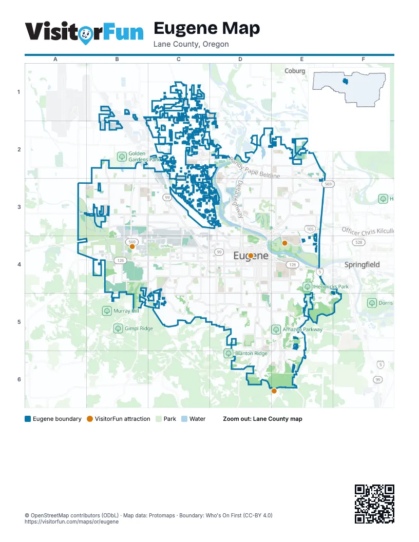
Street index of Eugene
Each street on the sheet and the grid squares it crosses.
- Randy Papé BeltlineB2, C2, D2, E2, B3, E3, B4
- Officer Chris Kilcullen Memorial HighwayD3, E3, D4
- Delta HighwayD2, D3
- Pacific Highway West #1W (91) Roadway #2E4
- Washington-Jefferson Street BridgeD3
- Pacific Highway West #1W (91) Roadway #1E4
- I-5 North Franklin BoulevardE4
- Prairie Road Connection #1C2
- Coburg RoadE2, D3, E3, D4
- West 11th AvenueB4, C4, D4
- Highway 99NB1, B2, C2, C3, C4
- River RoadC1, C2, D3
- Hilyard StreetD4, D5, E5
- Chambers StreetD3, D4, D5
- Franklin BoulevardE4
- West 7th AvenueB4, C4, D4
- Garfield StreetC3, C4, C5, D5
- Mill StreetD4, D5
- West 6th AvenueB4, C4, D4
- East 30th AvenueD5, E5
- Martin Luther King Junior BoulevardD3, E3, D4, E4
- Amazon ParkwayD4, D5, E5
- East 11th AvenueD4, E4
- Patterson StreetD4, D5
- East 13th AvenueD4, E4
- Highway 126A4, B4
- East BroadwayD4, E4
- East 23rd AvenueD4, E4
- Orchard StreetE4
- East 6th AvenueD4
- East 7th AvenueD4
- Prairie RoadC2
- Old Cannery ConnectorD4
- River Road NorthboundC2
- River Road SouthboundC2
- Broadway ConnectorD4
- West 18th AvenueB4, C4, D4
- Willamette StreetD4, D5, D6
- Roosevelt BoulevardB3, C3, D3
- Royal AvenueA3, B3, C3
- Barger DriveA3, B3, C3
- West 1st AvenueB4, C4, D4
- Bailey Hill RoadC4, B5, C5
- Goodpasture Island RoadD3
- Washington StreetD4, D5
- West 13th AvenueB4, C4, D4
- Jefferson StreetD4, D5
- Northwest ExpresswayC2, C3, D3
- Pearl StreetD4, D5
- South Bertelsen RoadB3, B4, C4, B5
- Oak StreetD4, D5
- West Amazon DriveE5, D6, E6
- West 28th AvenueC5, D5
- Fox Hollow RoadE5, D6, E6
- West 29th AvenueC5, D5
- East 19th AvenueD4, E4
- Cal Young RoadD3, E3
- North Danebo AvenueB2, B3, B4
- Lorane HighwayD5
- Irvington DriveB1, C1
- Harlow RoadE3
- East 18th AvenueD4, E4
- Willagillespie RoadD3
- Green Hill RoadA3, A4
- Oakway RoadE3
- Echo Hollow RoadB3
- Country Club RoadD3
- Maxwell RoadC2
- Irving RoadC2
- Valley River DriveD3
- Seneca RoadC4
- East 29th AvenueD5, E5
- Club RoadD3, D4, E4
- Airport RoadB2
- Southwood LaneD3, E3
- North Seneca RoadC3
- Glenwood DriveE4, F4
- North Game Farm RoadE2
- Cedarwood DriveD3, E3
- Glenwood BoulevardE4
- Maxwell ConnectorC2
- South Seneca RoadC3, C4
- North Terry StreetB2, B3
- Crescent AvenueD2, E2
- West 5th AvenueB4, C4, D4
- High StreetD4, D5
- Spring BoulevardE4, E5, E6
- Lincoln StreetD4, D5
- Monroe StreetD4, D5
- Alder StreetE4, E5
- Gilham RoadE2, E3
- Lawrence StreetD4, D5
- Olive StreetD4, D5
- Kincaid StreetE4, E5
- Donald StreetD5, D6
- Agate StreetE4, E5
- Polk StreetD4, D5
- Charnelton StreetD4, D5
- Avalon StreetA3, B3, C3
- Timberline DriveC5
- West 25th AvenueC5, D5
- Van Buren StreetD4, D5
- Willakenzie RoadE3
- Dillard RoadD5, E5, E6
- Bethel DriveC3
- East Amazon DriveE5, E6
- Fairmount BoulevardE4
- City View StreetC4, C5
- Harris StreetE4, E5
- West 24th AvenueC4, D4
- West 10th AvenueC4, D4
- West 8th AvenueC4, D4
- Willow Creek RoadB4
- Hawkins LaneC4, C5
- Goodpasture LoopD2, D3
- East 43rd AvenueD5, E5, E6
- Norkenzie RoadD2, D3
- Kevington AvenueC4, C5
- McLean BoulevardC5, D5
- West 2nd AvenueC4, D4
- Chad DriveE2, E3
- Warren StreetC4, C5
- West 19th AvenueC4, D4
- River AvenueC2, D2
- Elmira RoadB3, C3
- East 24th AvenueD4, E4
- Marshall AvenueB3, C3
- Cheshire AvenueC3, D3, D4
- Taney StreetC3
- Brittany StreetC4, C5
- Division AvenueC2, D2
- McKinley StreetC4
- Arthur StreetC4
- County Farm RoadE2
- River Loop 1D1, C2, D2
- North Delta HighwayD2
- North Shasta LoopE5
- North Park AvenueC3
- West 7th PlaceC4
- Bailey LaneE3
- Leo Harris ParkwayE4
- Dove LaneB3, C3
- Cubit StreetB2, B3
- Howard AvenueC2
- Ed Cone BoulevardB4
- Hunsaker LaneC2, D2
- Brae Burn DriveD5
- South Danebo AvenueB4
- Ayres RoadD2, E2
- Terry StreetB4
- Green Acres RoadD2
- Berntzen RoadC3
- West 3rd AvenueC4, D4
- East 40th AvenueD5, E5
- Blair BoulevardD4
- Wilkes DriveC1, D1
- Ferndale DriveC2
- North Bertelsen RoadB3
- Fairfield AvenueC3
- Center WayE6
- Wintercreek DriveC5
- Oakmont WayD3, E3
- South Garden WayE3, E4
- East 46th AvenueD5, D6
- Legacy StreetA3
- Railroad BoulevardD3, D4
- Horn LaneC3
- Brackenfern RoadE4, E5
- River Loop 2C1
- Silver LaneC2
- East 8th AvenueD4
- Park AvenueC3
- North Garden WayE3
- Pattison StreetC3
- Beacon Drive EastC1
- Old Coburg RoadE2, E3
- Oak Patch RoadC4
- Commerce StreetB4
- East 3rd AvenueD4
- Spring Creek DriveC1
- Jacobs DriveC3
- Shelton McMurphey BoulevardD4
- Owosso DriveC2
- West 39th AvenueD5
- Centennial LoopE3, E4
- East 10th AvenueD4
- East 5th AvenueD4
- Valley River WayD3
- Scenic DriveC1
- Summit AvenueE4
- Executive ParkwayD3
- Cornwall AvenueC3
- Kingsley RoadD3
- East 4th AvenueD4
- Hansen LaneC3
- Maple StreetC3
- Firland BoulevardE5
- North Garfield StreetC3
- Martin StreetE6
- Grove StreetC2
- North Washington StreetD3, D4
- East Enid RoadB1
- Crow RoadB4
- Madison StreetD4, D5
- Adams StreetD4, D5
- University StreetE4, E5
- Potter StreetE4, E5
- Ferry StreetD4, D5
- Onyx StreetE4, E5
- West 22nd AvenueC4, D4
- West BroadwayC4, D4
- Brookside DriveD5, D6
- West 12th AvenueC4, D4
- Tyler StreetD4, D5
- Taylor StreetD4, D5
- Fillmore StreetD4, D5
- West 27th AvenueC5, D5
- Emerald StreetE4, E5
- West 17th AvenueC4, D4
- Elysium AvenueE2, E3
- Grant StreetD4, D5
- West 15th AvenueC4, D4
- Lakewood CourtC3
- West 23rd AvenueC4, D4
- Friendly StreetD4, D5
- Spyglass DriveD3
- West 14th AvenueC4, D4
- East 15th AvenueD4, E4
- Riverview StreetE4, E5
- Summit Sky BoulevardC5
- Crest DriveD5
- North Clarey StreetB2, C2, B3, C3
- Hawthorne AvenueB3, C3, D3
- Jackson StreetD4, D5
- High AlleyD4, D5
- Villard StreetE4
- West 26th AvenueD5
- West 20th AvenueC4, D4
- Hyacinth StreetC1, C2
- Jessen DriveB2, C2
- East 17th AvenueD4, E4
- East 25th AvenueE4, F4, D5, E5
- Charnelton AlleyD4, D5
- Bell AvenueB3, C3
- Ridgeway DriveD3
- Almaden StreetD4, D5
- West 11th AlleyC4, D4
- Hayes StreetD4, D5
- Waite StreetC3
- West 16th AvenueC4, D4
- Wood AvenueB3, C3
- West 4th AvenueC4, D4
- Cross StreetB3, C3, D3
- West 21st AvenueC4, D4
- Laurelhurst DriveB2, B3
- Wilson StreetC4
- East 27th AvenueD5, E5
- Monroe AlleyD4, D5
- Throne DriveB3
- Lakeview DriveD2, E2
- Augusta StreetE4, E5
- East 32nd AvenueD5, E5
- Arrowhead StreetC1, C2
- Floral Hill DriveE4, E5
- Lawrence AlleyD4, D5
- East 36th AvenueD5, E5
- Praslin StreetB2, B3
- Alder AlleyE4, E5
- Laurel Hill DriveE4, E5
- East 20th AvenueD4, E4
- East 28th AvenueD5, E5
- East 26th AvenueD5, E5
- Mill AlleyD4
- Honeywood StreetE2
- Primrose StreetB2, B3
- Dogwood DriveB3, E5
- Concord StreetB3, C3
- Elizabeth StreetB2, B3
- East 39th AvenueD5, E5
- Olive AlleyD4, D5
- Tabor StreetD2, D3
- Portland StreetD4, D5
- Adelman LoopA3, B3
- Peppertree DriveC4
- Oak AlleyD4, D5
- Moon Mountain DriveE4, E5
- Hughes StreetC3
- East 22nd AvenueD4, E4
- Donohoe AvenueB3
- Stark StreetC1, C2
- Buck StreetC4
- Cleveland StreetC4, C5
- Covey LaneE4
- East 21st AvenueD4, E4
- Stewart RoadC4
- Arcadia DriveE3
- East 16th AvenueD4, E4
- Birch LaneE4
- East 14th AvenueD4, E4
- Russet DriveD3
Things to do on the Eugene map
Places on the map
- Alton Baker Disc Golf Course
- Alton Baker Park
- Amazon Ball Fields
- Amazon Field Forest
- Amazon Headwaters Park
- Amazon Parkway
- Ayers Lake
- Bertelsen Nature Park
- Bertelsen Slough
- Canoe Canal
- Churchill Sports Park
- Dedrick Slough
- Delta Oaks Shopping Center
- Delta Ponds
- Dragonfly Bend
- East Bank City Park
- Erin Noble Headwaters Park
- Eugene Country Club
- Eugene historic districts
- First Baptist Church of Eugene
- Flat Pond South
- Graham Field
- Hendricks Park
- J. H. Baxter Superfund Site
- John Serbu Youth Campus
- Lane Events Center
- Lane Memorial Gardens
- Laurelwood Golf Course
- Luk-wah Prairie
- Marist High School
- Maurie Jacobs Park
- Meadowlark Prairie
- Moon Mountain
- Mount Calvary Woods
- Oakmont Center
- Patterson Slough
- Skinner Butte City Park
- Tsal Luk-wah
- Valley River Center
- Willamette Daisy Meadow
Next to Eugene
- Coburg
- Springfield
© OpenStreetMap contributors, Open Database License, openstreetmap.org/copyright · Map data: Protomaps · Boundary: Who's On First (CC-BY 4.0); Quattroshapes (CC BY 2.0)