

Oregon map
Gladstone map
About 11,898 people live here (Census Bureau, 2024 estimate). The sheet's index lists 200 streets; Oatfield Road, Cornell Avenue and 82nd Drive cross the most grid squares. Also on it: Meldrum Bar Park, Billy Goat Island and Gladstone High School.
Open the map (PDF, US Letter)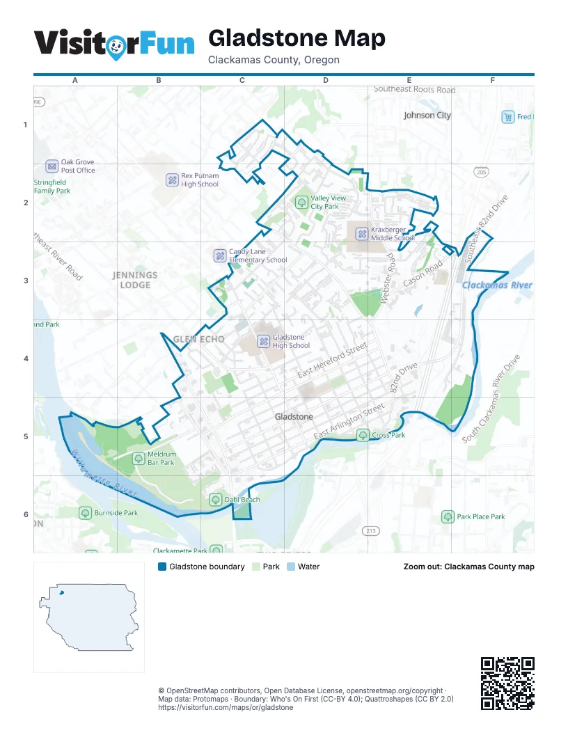
Street index of Gladstone
Each street on the sheet and the grid squares it crosses.
- Canterbury DriveC1
- Chessington CourtC1
- Chessington LaneC1, C2
- Devonshire DriveC1
- Doncaster DriveC1
- Londonderry LaneC1, D1
- Nottingham DriveC1, D1
- Paola CourtC1, C2
- Southeast Ormae RoadC1
- Buckingham CourtD1
- Buckingham DriveD1, D2
- Churchill DriveD1, D2
- Lancaster DriveD1
- Southeast Dagmar RoadD1
- Southeast Jennings AvenueD1
- Southeast Strawberry LaneD1
- Southeast Valley View RoadD1, D2
- Jade CourtC2
- Oakridge DriveC2, D2
- Oatfield RoadC2, D2, D3, E4
- Partridge CircleC2, D2
- Quail CourtC2
- Scott LaneC2, C3
- Southeast Oatfield RoadC2
- Southeast Pagoda CourtC2
- Braden CourtD2
- Caldwell RoadD2, C3
- Crownview CourtD2
- Crownview DriveD2
- Los Verdes DriveD2, E2
- Monte Verde DriveD2
- Monticello CourtD2
- Monticello DriveD2, D3
- Park WayD2, D3
- Ridgegate CourtD2
- Ridgegate DriveD2, D3
- Shawn CourtD2
- Southeast 6th AvenueD2
- Southeast Gladjen AvenueD2
- Trevor CourtD2
- Tudor CourtD2
- Tudor DriveD2
- Valley View DriveD2
- Via Del Verde DriveD2
- Via Monte Mar CourtD2
- Winfield CourtD2, D3
- Charolais CourtE2
- Charolais DriveE2
- Charolais WayE2
- Craig CourtE2
- Ridgewood DriveE2, E3
- Southeast Blinkhorn WayE2
- Southeast Cason LaneE2
- Southeast Lundgren WayE2
- Southeast Parkers DriveE2
- Springhill CourtE2
- Springhill DriveE2
- Springhill PlaceE2
- Timothy WayE2
- Webster RoadE2, E3, E4
- Southeast 82nd DriveF2, F3
- Southeast Hanson CourtF2
- Ben CourtC3
- Bird Song WayC3
- Cameron WayC3
- Chris CourtC3
- Cindy LaneC3
- Cornell PlaceC3, D3
- Cummings CourtC3
- Dickerson LaneC3
- Duniway AvenueC3, C4
- Durie CourtC3
- Echo WayC3, D3
- Franklin WayC3
- Glen Echo AvenueC3, D3, B4
- Glen Echo CourtC3
- Goetz RoadC3, D3
- Hardway CourtC3
- Harvard AvenueC3, D4, D5
- Larissa LaneC3
- Lynne CourtC3
- McCall CourtC3
- Nelson LaneC3, C4
- Petite CourtC3
- Portland AvenueC3, C4, D5
- Scott CourtC3
- Shawna LaneC3
- Southeast Hull AvenueC3
- Southeast Portland AvenueC3
- Sunlite CourtC3
- Tims View AvenueC3
- Tryon CourtC3
- Tryon WayC3
- Amonson CourtD3
- Angus WayD3
- Barbary CourtD3
- Barbary PlaceD3
- Beverly DriveD3, D4
- Beverly LaneD3, C4
- Clayton WayD3, E3
- Collins CrestD3
- Columbia AvenueD3, D4, E5
- Cornell AvenueD3, D4, D5, E5
- Debbie CourtD3
- Dierickx CourtD3
- Donna Lynn WayD3, D4
- East Kenmore StreetD3, D4
- High CourtD3, D4
- Penny CourtD3
- Stone Oaks CourtD3
- Stonehill StreetD3
- Stonewood CourtD3
- Stonewood DriveD3
- Cason CircleE3
- Cason RoadE3, F3
- Cottonwood CourtE3
- Dogwood CourtE3
- Kirkwood RoadE3
- Ridge DriveE3
- Rivergate School RoadE3
- Southeast Kirkwood RoadE3
- Southeast Madrona CourtE3
- 82nd DriveF3, E4, F4, E5
- Edgewater RoadF3, E4, F4
- Hattan CourtF3, F4
- Wheeler CourtF3
- Abernethy LaneB4, C4
- Manor DriveB4, C4
- Southeast Glen Echo AvenueB4
- Southeast McLoughlin BoulevardB4, B5, C5
- Southeast Mildred StreetB4
- Welter CircleB4
- Windsor DriveB4, C4
- Abernethy CourtC4
- Addie StreetC4
- Barclay AvenueC4
- Beatrice AvenueC4, C5
- Bellevue AvenueC4, C5, D5
- Center StreetC4
- East Gloucester StreetC4, D4, E4
- East Hereford StreetC4, D4, E4
- East Jersey StreetC4, D4
- Howell StreetC4
- Risley AvenueC4, C5
- Simmons CourtC4
- Sladen AvenueC4
- Watts StreetC4
- West Gloucester StreetC4, C5
- West Hereford StreetC4, C5
- West Ipswich StreetC4
- West Jersey StreetC4
- West Kenmore StreetC4
- Alli CourtD4
- Chicago AvenueD4, D5
- Dennis WayD4
- East Clarendon StreetD4, E4, D5
- East Dartmouth StreetD4, E4, D5
- East Exeter StreetD4, E4, D5
- East Fairfield StreetD4, E4, D5
- Heather WayD4, E4
- High StreetD4
- Kelsey CourtD4
- Landon StreetD4
- Patricia DriveD4
- Union AvenueD4, E4
- Yale AvenueD4, D5
- East Arlington StreetE4, D5, E5
- East Berkeley StreetE4, D5, E5
- Princeton AvenueE4
- River LaneE4
- Evergreen LaneF4
- Meldrum Bar Park RoadA5, B5
- Apollo DriveB5, C5
- Dahl Park RoadB5, B6
- Explorer AvenueB5
- Jupiter WayB5
- Mercury AvenueB5
- Mercury StreetB5, C5
- River RoadB5, C5
- Riverdale DriveB5
- Southeast Jay StreetB5
- Southeast Kay StreetB5
- Southeast Rinearson RoadB5
- Southeast River RoadB5, C5, C6
- Telstar AvenueB5
- Titan AvenueB5
- Venus AvenueB5
- Barton AvenueC5
- Gloucester StreetC5
- McLoughlin BoulevardC5, C6
- Saturn CourtC5
- West Arlington StreetC5, D5, C6
- West Berkeley StreetC5, D5
- West Clackamas BoulevardC5, D5
- West Clarendon StreetC5, D5
- West Dartmouth StreetC5, D5
- West Exeter StreetC5, D5
- West Fairfield StreetC5, D5
- East Clackamas BoulevardD5, E5
- East First StreetD5, E5
Places on the map
- 24 Hour Fitness
- A1 Hawk
- Affordable Classics
- All Cars Auto Sales
- Alliance Chimney
- ampm
- Armstrong Volkswagen
- Autotown GMC
- Billy Goat Island
- Budget Inn
- Charles Ames Memorial City Park
- Chevron
- Clackamas River Plaza
- Clackamas River Racquet Club
- Cross Park
- Crown Motors PDX
- Dahl Beach
- David M. Scott Park
- Dick Hannah Nissan
- Dierickx Memorial Park
- Flying A Service
- Former Gladstone City Library
- Gladstone Christian Church
- Gladstone Civic Center
- Gladstone Community Center
- Gladstone Crossing
- Gladstone High School
- Gladstone Nature Park
- Holiday Inn Express
- Kraxberger Middle School
- Meldrum Bar Park
- Northwest Self Storage
- Olson Property
- Oregon Conference of Seventh-day Adventists
- Rivergreens Golf Club
- Somerset
- Somerset Lodge
- Valley View City Park
- Volcano Harley-Davidson
- Whetten Elementary School
Next to Gladstone
- Clackamas Heights
- Jennings Lodge
- Johnson City
© OpenStreetMap contributors, Open Database License, openstreetmap.org/copyright · Map data: Protomaps · Boundary: Who's On First (CC-BY 4.0); Quattroshapes (CC BY 2.0)















