

Oregon map
Grants Pass map
About 39,468 people live here (Census Bureau, 2024 estimate). The sheet's index lists 300 streets; Redwood Highway, Williams Highway and Grants Pass Parkway cross the most grid squares. Things to do inside the boundary: Hellgate Jetboat Excursions and The Glass Forge Gallery & Studio.
Open the map (PDF, US Letter)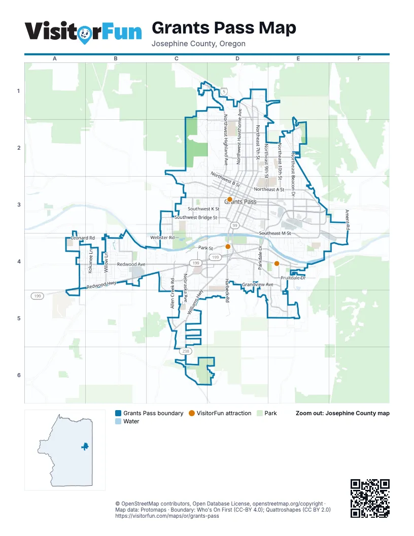
Street index of Grants Pass
Each street on the sheet and the grid squares it crosses.
- Highway #001CQ - East Grants Pass Connection #2E3
- Redwood HighwayA4, B4, C4, D4, A5
- Grants Pass ParkwayD3, E3, D4
- Williams HighwayC4, D4, C5, C6
- Northeast 7th StreetD1, D2, D3
- Northeast F StreetD3, E3
- Rogue River HighwayD4, E4
- Northwest 6th StreetD1, D2, D3
- Willow LaneB4
- Southeast 7th StreetD3, D4
- Northeast E StreetD3, E3
- Southeast 6th StreetD3
- Southwest 6th StreetD3, D4
- Northeast 6th StreetD2, D3
- Demaray DriveB4
- North 6th StreetD1
- North Grants Pass Interchange Connection #1D1
- Redwood AvenueA4, B4, C4
- Northwest Highland AvenueC1, D1, D2
- Fruitdale DriveD4, E4
- Northwest F StreetC3, D3
- Cloverlawn DriveE4, E5
- Southwest G StreetC3, D3
- Northwest 3rd StreetD2, D3
- Parkdale DriveD4
- Northwest E StreetD3
- Northeast Agness AvenueE3, E4
- Hamilton LaneE4
- Northwest Dimmick StreetD2, D3
- New Hope RoadC5
- Foothill BoulevardE3
- Rogue River Loop RoadC3
- Northeast Beacon DriveE2, E3
- Leonard RoadA4, B4
- East Park StreetD4, E4
- West Harbeck RoadC4, C5, D5
- Northeast D StreetD3, E3
- Southeast M StreetD3, D4, E4
- Northwest Hawthorne AvenueD1, D2
- Southwest Bridge StreetC3, D3
- Northwest Washington BoulevardD1, D2
- Northeast 9th StreetD2, D3
- Northeast A StreetD3, E3
- Southeast N StreetE4
- Northeast 10th StreetE2, E3
- Ramsey AvenueC4, D4
- Grandview AvenueD4, E4
- Northwest Vine StreetD1, D2
- Nebraska AvenueC4, C5
- Northwest Morgan LaneC1, D1, D2
- Allen Creek RoadC4, C5
- West Park StreetC4, D4
- Union AvenueC4, D4
- Northeast Savage StreetD2, E2
- Haviland DriveE4, E5
- Northwest A StreetD2, D3
- Northwest D StreetD3
- Southeast J StreetD3, E3
- Dowell RoadB4
- North Harbeck RoadD4, D5
- Northwest 4th StreetD2, D3
- Ringuette StreetC4, D4
- Northeast Spalding AvenueE3, E4, F4
- Darneille LaneA4
- Northwest Savage StreetD2
- Webster RoadC4
- Northwest Midland AvenueD2
- Northeast Fairview AvenueE3
- Lower River RoadC3
- Southwest Pine StreetD3
- Northwest 2nd StreetD2, D3
- Hubbard LaneA4
- Northeast Terry LaneE3
- Southeast 9th StreetD3
- Northeast Foothill BoulevardE3
- Lincoln RoadC3, C4
- Northeast Hillcrest DriveD2, E2
- Southeast Mill StreetD3, E3, D4
- Drury LaneD4
- Southwest 4th StreetD3
- Westholm AvenueC3
- Scoville RoadD1
- Southeast G StreetD3
- Espey RoadC6
- Northeast Mill StreetE3
- Northwest Evelyn AvenueD2
- Meridian WayC4, D4
- Northwest Hillcrest DriveD2
- Fairgrounds RoadC4
- Northwest Booth StreetD3
- Southwest M StreetD3
- Northeast Anderson StreetE3
- Northwest Scenic DriveD1
- Northeast Evelyn AvenueD2
- Southwest Hubbard LaneA4, A5
- Skycrest DriveD5
- Northeast Morgan LaneD1
- Harbeck RoadD4, D5
- Southwest Booth StreetD3
- Ament RoadF3
- Schroeder LaneB4
- Northwest Starlite PlaceC2, D2
- Southwest K StreetC3, D3
- Northwest B StreetC2, D2, D3
- Southwest I StreetC3, D3
- Southwest J StreetC3, D3
- Kellenbeck AvenueB4
- Kokanee LaneB4
- Northeast 8th StreetD2, D3
- Southwest Rogue River AvenueC3, D3
- Southwest L StreetC3, D3
- Elmer Nelson LaneA4, B4
- Southwest Foundry StreetC3, D3
- Northwest C StreetD3
- Southwest Oak StreetD3
- Northwest Valley View DriveC2, D2
- Northwest Sun View PlaceC2, C3
- Northwest Lawnridge AvenueD2
- Southwest 5th StreetD3
- Sunglo DriveB4
- Esther LaneB4
- George Tweed BoulevardB4
- Northwest Cooke AvenueC1, D1
- Southwest H StreetD3
- Northeast 11th StreetE2, E3
- Southeast Portola DriveE4
- Greenwood AvenueC3, C4
- Southwest Wagner Meadows DriveC3
- Northwest Manzanita AvenueD2
- Gaffney WayD4, D5
- Southwest Jordan StreetC3, D3
- Southeast 8th StreetD3
- Northwest Prospect AvenueD2
- Western AvenueC3
- Southwest Spruce StreetC3, C4
- Southeast Rogue DriveE4
- Leonard StreetC3
- Northeast Madrone StreetD3, E3
- Northwest 5th StreetD2, D3
- Northwest Crescent DriveC2
- Ironwood DriveC3, C4
- Northeast 12th StreetE2, E3
- Northwest Conklin AvenueD2
- Crown StreetC1, D1, C2
- Northwest Elm DriveD2, D3
- Medart LaneB4
- Southwest Central AvenueC3, D3
- Southeast L StreetD3
- Northeast Industry DriveE3, F3, F4
- Panoramic LoopE5
- Northeast Scenic DriveD1
- Wheeler StreetB4
- Southeast Ashley PlaceE3, E4
- Southeast 10th StreetD3
- Northwest Bellevue PlaceD2
- Raydean DriveB4
- Northwest Regent DriveC1, D1
- South Schutzwohl LaneC4
- Southwest Isham StreetC3, D3
- Southeast K StreetD3
- Southeast I StreetD3
- Northeast Greenfield RoadD1
- Southeast Linden LaneE5
- Mesman DriveB4
- Northeast Terrace DriveE2
- Southeast H StreetD3
- Northeast Dewey DriveE2
- Redwood CircleD1, D2, C4
- Wineteer LaneB4, C4
- Annabelle LaneB4
- Southeast Riverside AvenueD3
- Marion LaneC4, D4
- Galaxy WayA4
- Towne StreetC5, D5
- Northwest Fry StreetD2, D3
- Southwest Cottonwood StreetC3, C4
- Moon Glo DriveB4
- Meadow GlenC4, C5
- Ausland DriveD1
- Morgan LaneD1, D2
- Delsie DriveB4
- Mayfield StreetE5
- Northwest Wrightwood CircleD1
- Black Oak DriveD2, C6
- Southeast 11th StreetD3
- Liberty DriveD4
- Northwest Candler AvenueD1, D2
- Southeast Elderberry LaneE5
- Idle CourtD4
- Curtis DriveC5
- Southwest Sturgeon CourtB4
- Independence DriveD4
- Sunset WayD4
- Eastwood LaneA4, B4
- Schutzwohl LaneB4
- Northwest North Hill DriveD1
- Waterstone DriveA4, B4
- Northeast C StreetD3
- Northeast Wharton DriveD3, E3
- Florer DriveC5
- Southwest Burgess StreetD3
- Brownell AvenueC3
- Southwest Doneen LaneC3, C4
- Northeast Memorial DriveD2, E2
- Northeast Oakdale DriveD1, E1
- Northeast Dean DriveD3
- Northeast Steiger StreetD2
- Northeast B StreetD3
- Churchill StreetE2
- Northeast Hefley StreetE2
- Lilac LaneD4
- Morris LaneC6
- Vista DriveD4
- Regina WayC4, C5
- Hilltop DriveD4
- Southeast Golden Park DriveD4
- Robertson CrestE5
- Yorktown RoadD4
- Willow CourtB4
- Northeast Outlook AvenueD2, E2
- Northwest Woodson DriveC2, D2, D3
- Northeast Piedmont AvenueE3
- Southeast Belle Aire DriveE4
- Fall Run DriveC2, C3
- Southwest Yucca DriveB4
- Southridge WayD4
- G I LaneD4
- Southeast Clarey AvenueE4
- Southwest Laurel StreetC3
- Northwest Sunset DriveD2
- Southeast Gladiola AvenueE4
- Tokay HeightsE3
- Florence LaneD4
- Northeast Beverly DriveE2
- Northeast Oregon StreetE3
- Southwest Susan LaneC3
- Shimmer LaneA4, B4
- Southwest Cypress StreetC3
- Shady LaneC4
- Cedar LoopD1, D2, E2
- Northwest Clarke StreetD3
- Northwest Pleasant View DriveD2
- Southwest Wildwood StreetC3
- Southeast Allenwood DriveC5
- Whispering DriveC6
- Southeast Fern StreetE4
- Short StreetD4
- Cullison DriveC5
- Southeast Cherry LaneE4
- Edgewater DriveC4, D4
- Carnahan DriveE4
- Southeast Oriole StreetE4
- Hungry Hill DriveC4, C5
- Northwest Sinclair DriveC1, D1
- Northeast Meier DriveE3
- Northeast Grable DriveE3
- Native Run LoopC2, C3
- Southeast Wagon Wheel DriveC5
- Mayfair LaneC5
- North Star DriveB4
- Northwest Gilbert WayD2
- Devonshire WayB4
- Playford LaneD4
- Southwest Hall StreetC3
- Northeast Flint DriveD3
- Northeast Baker DriveE3
- Osprey DriveC4
- Tussey LaneD4
- David DriveB4
- Northeast Ridge RoadE2
- Southwest Lee LaneD3, D4
- Southwest Lewis AvenueD4
- Northeast Sovereign StreetE3
- Northeast Westbrook WayD3, E3
- Northwest Carol DriveD1
- Bailey DriveD4
- Daisy LaneC4
- Poplar StreetD4
- Northeast Royal DriveE3
- Northwest Sunhill DriveC2, C3
- Abby LaneB4
- Grandview LaneD4
- Southwest Judson StreetD3
- Southwest Alder StreetC3
- Coach DriveC5
- Larch RoadC3
- Northwest Bunnell AvenueD2
- Southwest Eastern AvenueC3
- Parker DriveD2
- Monroe WayE5
- Southwest Grant StreetC3, D3
- Northeast Hillcrest LaneE2
- Bower LaneD4
- Northeast Heritage DriveE3
- Nunnwood LaneB4
- Marjean LaneE4
- Coriander WayE5
- Northwest Grant StreetD2
- Northeast Mead StreetD2
- Clara AvenueE4
Things to do on the Grants Pass map
Places on the map
- 7-Eleven
- Abby's Legendary Pizza
- Albertsons
- Allen Creek Commercial Center
- Applebee's
- Arco
- Asante Three Rivers Medical Center
- AutoZone
- Baker Park
- Barnstormers Theatre
- Best Western Grants Pass Inn
- Bestway Inn Grants Pass
- Bi-Mart
- College Heights Baptist Church
- Dutch Bros Soccer Complex
- Fred Meyer
- Garrison Park
- George H Eckstein Park
- Grants Pass DCU Post Office
- Grants Pass Golf Club
- Grants Pass High School
- Grants Pass Post Office
- Highland Elementary School
- Josephine Community Library
- Josephine County Fairgrounds
- Lincoln Elementary School
- Morrison Park
- North Middle School
- Parkside Elementary
- Redwood Elementary School
- Redwood Park
- Reinhart Volunteer Park
- Riverside Park
- Rogue Christian Academy
- Rogue Valley Youth Correctional Facility
- Souther Oregon Sanitation
- The Home Depot
- Walmart Supercenter
© OpenStreetMap contributors, Open Database License, openstreetmap.org/copyright · Map data: Protomaps · Boundary: Who's On First (CC-BY 4.0); Quattroshapes (CC BY 2.0)















