

Oregon map
Josephine County map
About 88,276 people live here (Census Bureau, 2024 estimate). The sheet's index lists 300 streets; Redwood Highway, Briggs Valley Road and Williams Highway cross the most grid squares. Things to do inside the boundary: Morrison's Rogue Wilderness Lodge, Grants Pass and Great Cats World Park.
Open the map (PDF, US Letter)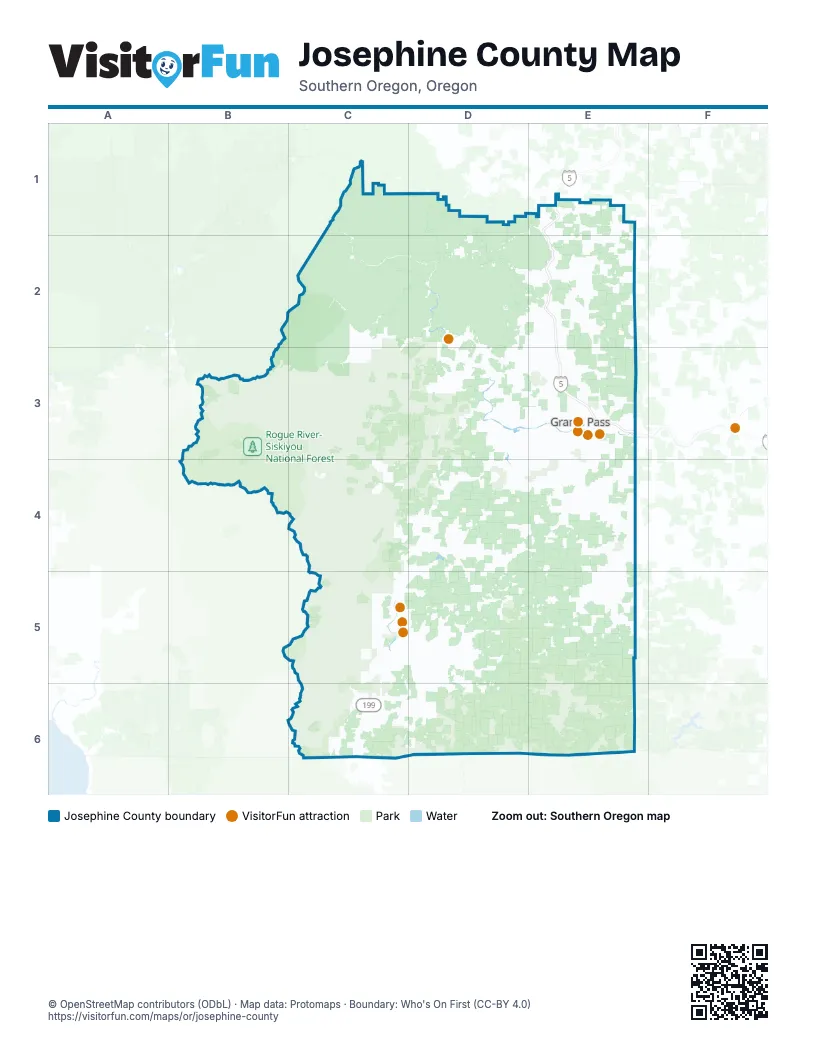
Maps inside Josephine County
1 map inside, from the street map of Josephine County down.
Street index of Josephine County
Each street on the sheet and the grid squares it crosses.
- Highway #001CQ - East Grants Pass Connection #2E3
- Highway #001CP - East Grants Pass Connection #1E3
- 001CQ E GRANTS PASS CONN. NO. 2 LEGE3
- Redwood HighwayD3, E3, D4, C5, D5, C6
- Williams HighwayE3, E4, E5
- Rogue River HighwayE3
- Demaray DriveD3, E3
- Grants Pass ParkwayE3
- Northeast 7th StreetE3
- Northeast F StreetE3
- Northwest 6th StreetE3
- Willow LaneE3
- Southeast 7th StreetE3
- Northeast E StreetE3
- Southeast 6th StreetE3
- Southwest 6th StreetE3
- North Redwood HighwayC5
- Northeast 6th StreetE3
- South Redwood HighwayC5
- North 6th StreetE3
- North Grants Pass Interchange Connection #1E3
- Galice RoadD2, D3
- Caves HighwayC5, D5, E5
- Happy Camp RoadD6
- Lower River RoadD3, E3
- Riverbanks RoadD3
- Rockydale RoadC5, D5, D6
- Fish Hatchery RoadD4, E4
- Monument DriveE2, E3
- New Hope RoadE3, E4
- Redwood AvenueD3, E3
- Cloverlawn DriveE3, E4
- Waldo RoadC6, D6
- Upper River RoadD3, E3
- Highland AvenueE3
- Foothill BoulevardE3
- Southside RoadE4
- Jerome Prairie RoadE3, D4, E4
- Merlin RoadD3, E3
- Murphy Creek RoadE4
- Robertson Bridge RoadD3
- Pleasant Valley RoadE2, D3, E3
- Stringer Gap RoadE4
- Fruitdale DriveE3
- Jaynes DriveE4
- Northwest Highland AvenueE3
- Hamilton LaneE3
- Old Redwood HighwayD4, C5
- Helms RoadD3, D4
- Northwest F StreetE3
- Southwest G StreetE3
- Northwest 3rd StreetE3
- Parkdale DriveE3
- Northwest E StreetE3
- Northeast Agness AvenueE3
- Oregon Caves HighwayD5
- Northwest Dimmick StreetE3
- Rogue River Loop RoadE3
- Jumpoff Joe Connection #2E2
- Briggs Valley RoadC3, D3, C4, D4
- Bear Camp RoadC2, D2
- Illinois River RoadC4, D4
- Cedar Flat RoadD5, E5
- Forest Road 4201C4, C5
- Lower Grave Creek RoadD2
- Grayback RoadD5, E5
- Wimer RoadC6
- Taylor Creek RoadD2, C3, D3
- Takilma RoadD5, D6
- Deer Creek RoadD4
- Coyote Creek RoadE1, E2
- Powell Creek RoadE4, E5
- Thompson Creek RoadD4, D5, E5
- Shan Creek RoadD3
- Holland Loop RoadD5
- Westside RoadC5
- North Applegate RoadE4
- Hugo RoadD2, E2, D3
- Lakeshore DriveD4
- Granite Hill RoadE3
- Azalea DriveD3, E3
- Old Highway 99E1, E2
- Jumpoff Joe Creek RoadE2
- Lower Wolf Creek RoadD1, E1, D2
- Reeves Creek RoadD4, C5, D5
- Dick George RoadD5, D6
- Onion Mountain RoadC3, D3
- South Fork Deer Creek RoadD4, D5, E5
- Water Gap RoadE4, E5
- Placer RoadE2
- Leonard RoadD3, E3
- Winona RoadE2, E3
- Low Divide RoadE5
- Leland RoadD2, E2
- Bear Creek RoadD5
- Midway AvenueE3, E4
- Draper Valley RoadD4
- Sunny Valley LoopE2
- Forest Road 10E5
- Pine Crest DriveE3
- Russell RoadE2, E3
- Kincaid RoadE5
- Soldier Creek RoadE3
- White School House RoadD5
- West Jones Creek RoadE3
- Caves Camp RoadE5
- East Jones Creek RoadE3
- Marcy Loop RoadD3
- Laurel RoadC5, D5
- Lone Mountain RoadC6
- Hayes Hill RoadD4
- Tunnel Loop RoadD2, E2
- Crow RoadD3
- Ewe Creek RoadD3
- Donaldson RoadE3
- Pearce Park RoadE3
- Three Pines RoadE2
- Saratoga WayE3
- Grays Creek RoadE4
- Northeast Beacon DriveE3
- Pickett Creek RoadD3
- Oxyoke RoadE2
- Applegate AvenueD3
- Frontage RoadE1
- Elk LaneE3, E4
- Woodland Park RoadD3, D4
- Walker RoadE3
- East Park StreetE3
- West Harbeck RoadE3
- Camp Joy RoadE3
- Northeast D StreetE3
- Southeast M StreetE3
- Averill DriveE3
- Plumtree LaneE3
- Allen Creek RoadE3
- Northwest Hawthorne AvenueE3
- Southwest Bridge StreetE3
- Northwest Washington BoulevardE3
- Little Sugarloaf RoadE5
- Northeast 9th StreetE3
- Northeast A StreetE3
- Hogue DriveD4
- Kubli RoadE4
- North Old Stage RoadC5
- Northwest Vine StreetE3
- Northeast 10th StreetE3
- Naue WayC6
- North Harbeck RoadE3
- Brookside BoulevardE3
- Skyway DriveE3
- Grandview AvenueE3
- Hays Cutoff RoadD5
- Horseshoe DriveE3
- Sand Creek RoadE3
- Dowell RoadE3
- Southeast N StreetE3
- South River RoadE3
- Hidden Valley RoadE4
- Lincoln RoadE3
- Detrick DriveE4
- Ramsey AvenueE3
- Northeast Hillcrest DriveE3
- O'Brien RoadC6
- Nebraska AvenueE3
- Laurel AvenueD3, E3
- Fernwood DriveC5
- Northwest Morgan LaneE3
- West Park StreetE3
- Finch RoadC5
- East Intervale RoadE4
- Lonnon RoadE3
- Lariat DriveE2
- Northeast Spalding AvenueE3
- Darneille LaneE3
- East River StreetC5, D5
- Grouse Creek RoadE3
- Rounds AvenueE3
- College DriveE3
- Northwest Scenic DriveE3
- Union AvenueE3
- Northeast Savage StreetE3
- Haviland DriveE3
- Mesa Verde DriveC5
- Douglas DriveD3
- Webster RoadE3
- Hunt LaneE3
- Espey RoadE3, E4
- Jenkins AvenueE3
- Smith Sawyer RoadD5
- West River StreetC5
- Skycrest DriveE3
- Northwest A StreetE3
- Northwest D StreetE3
- Southeast J StreetE3
- Forest Road 087C4
- Carton WayE3
- Boundary RoadE3
- Kelsey Mule RoadC1
- Northwest 4th StreetE3
- Genverna GlenE4
- Ringuette StreetE3
- Ament RoadE3
- Lloyd DriveE3
- Southwest Hubbard LaneE3
- Northwest Savage StreetE3
- Northwest Midland AvenueE3
- Northeast Fairview AvenueE3
- Nelson WayE3
- Ponderosa LaneE3
- Coutant LaneE3
- Wolf LaneE3
- Southwest Pine StreetE3
- Dryden RoadD4
- California AvenueE3
- Scoville RoadE3
- Northwest 2nd StreetE3
- Honeylynn LaneE4
- Hubbard LaneE3
- Northeast Terry LaneE3
- Schroeder LaneE3
- Watergap RoadE4
- Southeast 9th StreetE3
- Northeast Foothill BoulevardE3
- Southeast Mill StreetE3
- County Highway 5070D4
- Drury LaneE3
- Southwest 4th StreetE3
- Westholm AvenueE3
- Cascade DriveC5
- East Glenwood StreetE4
- Azalea Drive CutoffE3
- Southeast G StreetE3
- North Valley DriveE3
- Northeast Mill StreetE3
- Northwest Evelyn AvenueE3
- Meridian WayE3
- Northwest Hillcrest DriveE3
- Arnold AvenueE3
- Front StreetE1, E3
- Fairgrounds RoadE3
- Northwest Booth StreetE3
- Jaime LaneE3
- Mount Baldy RoadE3
- Southwest M StreetE3
- Northeast Anderson StreetE3
- Northeast Evelyn AvenueE3
- Commerce WayE3
- Northeast Morgan LaneE3
- Bridgeview-Takilma RoadD5, D6
- Harbeck RoadE3
- Southwest Booth StreetE3
- Patrick Creek RoadC6
- French Peak RoadD6
- Forest Road 4105C4
- Sucker Creek RoadD5, D6
- Flat Top RoadC3
- Steve Fork RoadE6
- Buck Peak RoadD5, E5
- Long Gulch RoadC2
- Hog Creek RoadD2
- Peavine RoadC2, D2
- Forest Road 9938C6
- East Fork RoadE5
- Serpentine Spring RoadC2
- North Fork Silver Creek RoadC2, C3
- Galice Access RoadC2
- Grave Creek RoadE2
- Burgess Gulch RoadE2
- Waters Creek RoadD3, D4
- Forest Road 1040-400E6
- Forest Road 025C6, D6
- Sturgis Creek RoadE5, E6
- Mount Reuben RoadD2
- Speaker RoadE1
- Forest Road 1035E6
- White Creek East RoadD4, D5
- West Sauageck 6211E3, E4
- Crooks Creek RoadD4
- Bigelow Lakes RoadE5
- Missouri Flat RoadE4
- Cheney Creek RoadD4
- Forest Road 1035-350E6
- Abegg RoadD3
- Althouse Creek RoadD5, D6
- Arrowhead DriveC6
- King Mountain RoadE1, E2
- Davis Creek RoadD4
- Airport DriveC5, C6
- Bridge LaneE1, E2
- Gunnell RoadD3
- McMullin Creek RoadD4, D5
- Limpy Creek RoadD3
- King Mountain TrailE2
- North Fork Thompson Creek RoadD5
- Shanks Creek RoadE2
- Sleepy Hollow LoopD4, E4
- Bolan Lake RoadD6
- White Creek RoadD4, D5
- Stewart RoadD3
- Dutcher Creek RoadD3
Things to do on the Josephine County map
Places on the map
- Applegate River
- BLM Provolt Recreation Site
- Brewer Spruce Instant Study Area
- Cathedral Hills
- Cave Junction
- Days Gulch Botanical Area
- Eight Dollar Mountain Area of Critical Environmental Concern
- Eight Dollar Mountain Botanical Area
- Esterly Lakes
- Fish Hatchery County Park
- Foris Vineyards
- Golden Coyote Wetland, historic mining area
- Grants Pass
- Grants Pass Golf Club
- Grants Pass High School
- Illinois River Forks State Park
- Illinois Valley Airport
- Illinois Valley Golf Club
- Illinois Valley High School
- Josephine County Fairgrounds
- King Mountain Rock Garden ACEC
- Lake Selmac
- Lake Selmac County Park
- Lake Selmac Disc Golf Course
- Manzanita Rest Area Northbound
- Manzanita Rest Area Southbound
- Miller Lake Trail
- Morrison's Rogue River Lodge
- North Valley High School
- Oregon Caves National Monument
- Oregon Caves National Preserve
- Oregon Mountain Botanical Area
- Osprey Loop
- Pacifica: A Garden in the Siskiyous
- Redwood
- Reinhart Volunteer Park
- Rogue River-Siskiyou National Forest
- Rough and Ready Botanical Area
- Woodcock Bog RNA (BLM)
- York Creek Botanical Area
© OpenStreetMap contributors, Open Database License, openstreetmap.org/copyright · Map data: Protomaps · Boundary: Who's On First (CC-BY 4.0); Quattroshapes (CC BY 2.0)















