

Oregon map
Hermiston map
About 19,746 people live here (Census Bureau, 2024 estimate). The sheet's index lists 300 streets; Feedville Road, Umatilla-Stanfield Highway and Southeast 10th Street cross the most grid squares. Also on it: Hermiston Municipal Airport, Armand Larive Middle School and Good Shepherd Medical Center.
Open the map (PDF, US Letter)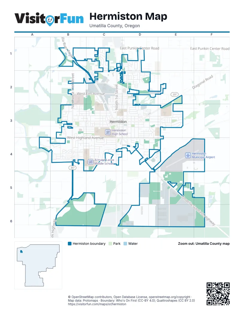
Street index of Hermiston
Each street on the sheet and the grid squares it crosses.
- Umatilla-Stanfield HighwayC3, D4, E5, F6
- North 1st StreetC1, C2, C3
- Northwest 11th StreetB1, B2, B3
- Southwest 11th StreetB3, B4, B5
- West Elm AvenueB2, C2
- East Elm AvenueC2, D2
- Butter Creek HighwayB5
- East Main StreetC3, D3, E3
- West Highland AvenueB4, C4
- East Highland AvenueC4, D4, E4
- Umatilla River RoadB1, B2, C2
- West Hermiston AvenueB3, C3
- North 1st PlaceC2, C3
- Diagonal BoulevardD3, E3
- West Highland ExtensionA3
- Feedville RoadB6, C6, D6, E6, F6
- Northeast 4th StreetD1, D2, D3
- Southeast 10th StreetE3, E4, E5, E6
- West Orchard AvenueB3, C3
- South 1st StreetC3, C4
- East Theater LaneC2, D2
- Kelli BoulevardE5, E6
- Northeast 10th StreetE2, E3
- West Punkin Center RoadB1, C1
- Southeast 4th StreetD3, D4
- Northwest Geer RoadC1, C2
- West Harper RoadC2
- West Locust AvenueC3
- West Theater LaneC2
- South 1st PlaceC3
- East Hooker RoadE2
- Cooney LaneB1
- South Ott RoadF4, F5, F6
- Southeast 9th StreetD3, D4, D5, D6
- East Newport AvenueC3, D3, E3
- Airport WayE4, F4
- Southwest 9th StreetB3, B4
- East Hurlburt AvenueC3, D3, E3
- East Penney AvenueD5, E5, D6, E6
- West Ridgeway AvenueB3, C3
- West Joseph AvenueB4, C4
- Southwest 10th StreetB3, B4
- Southwest 7th StreetC3, C4
- Northeast 8th StreetD1, D2, D3
- West Hartley AvenueB3, C3
- East Ridgeway AvenueC3, D3, E3
- East Gladys AvenueC3, D3, E3
- Northeast 6th StreetD1, D2, D3
- West Madrona AvenueB3, C3
- Northwest 3rd StreetC2, C3
- Southeast 8th StreetD3, D4
- West Division AvenueB4, C4
- East Pine AvenueD3
- Northeast 8th PlaceD2, D3
- East Jennie AvenueC3, D3
- East View DriveD4, E4
- Northwest Eucalyptus DriveC1, C2
- Northeast 7th StreetD1, D3
- Northeast 2nd StreetD1, D2, C3
- Hinkle Motel RoadF6
- South Townsend RoadE3
- East Catherine AvenueC3, D3
- West Sunland AvenueB4
- Southwest Cottonwood DriveC4
- Gettman RoadB5, C5
- Northwest 7th StreetC2, C3
- West Moore AvenueC4
- Southeast Campbell DriveE5, E6
- Northeast Gladys DriveE3
- East Oregon AvenueC2, D2
- Northeast Alora DriveD1, D2
- Southeast 5th StreetD3, D4
- West Standard AvenueC3
- East Airport RoadE5
- East Montana AvenueD2
- Shannon WayE5
- Southwest River Hill DriveA4, B4
- Southeast 6th StreetD3, D4
- Southwest Desert View DriveC4
- Northeast North StreetC1, C2, C3
- Southwest 6th StreetC3, C4
- Southwest 13th PlaceB3, B4
- Northwest 12th StreetB3
- Southeast 7th StreetD3, D4
- East Autumn AvenueD2
- West Juniper AvenueB3, C3
- West Cedar DriveC4
- West Johns AvenueB4, C4
- Northeast Aspen DriveD2
- Northwest 10th StreetB3
- Northeast Gillespie LaneE3
- Southeast 9th DriveD3, D4
- Southwest 17th StreetA4, B4
- East Quince AvenueD3
- Northwest 6th StreetC2, C3
- Southeast 3rd StreetD3
- West Nelson LaneB2, C2
- Northwest Overlook DriveC1
- East Wilshire AvenueD3
- East Sunset DriveD3
- Port DriveD4
- Northeast 3rd StreetD3
- Northwest Dawn DriveC1
- East Browning AvenueD2
- Columbia DriveD4, E4
- Southwest 4th StreetC3, C4
- Southwest Desert Oak DriveB4
- East Highland ExtensionE4, F4
- Northwest 2nd StreetC2, C3
- West Alder AvenueB3, C3
- North McNary StreetC2, D2, C3
- Southwest 3rd StreetC3, C4
- East Tamarack AvenueD3
- Northeast 9th PlaceD2
- West Alleluia AvenueA4
- Northwest 13th StreetB3
- West Pine AvenueB3, C3
- West Quince AvenueB3, C3
- Northwest 9th StreetB3
- West Angus AvenueB4
- West Duane AvenueB4, C4
- West Tamarack AvenueB3, C3
- West Juanita AvenueB3
- East Beebe AvenueC2, D2
- East Beech AvenueC2, D2
- East Dogwood AvenueC2, D2
- West Hensel RoadB1, C1
- Northwest Butte DriveC3
- East McKinney AvenueC4
- Northeast Madrona DriveE3
- Birch DriveB3, B4
- Northwest Dusk DriveC1
- East Reeder DriveD3
- West Kenna DriveD2
- Southeast 19th StreetE5, F5
- Southeast Banker DriveD4
- West Stockton StreetC2
- Southwest 10th PlaceB4
- West Laird AvenueC4
- West McKenzie AvenueC4
- S StreetB4
- Northeast 5th StreetD2, D3
- West Jennie AvenueC3
- West Park AvenueC3
- Northwest Valley View DriveC1
- Southwest Sandy DriveB4
- West Cody AvenueB4
- West Poplar AvenueB3
- Maughan LaneB4
- Southwest Sage DriveB4
- Southwest Meadow View DriveB4
- Southeast 2nd StreetC3
- West Beech AvenueC2
- East McKenzie AvenueD4
- West Beebe AvenueC2
- West Sandpiper AvenueC4
- West Pheasant AvenueC4
- West Wren AvenueC4
- West Cherry AvenueC2
- East Sandstone AvenueE3
- Northeast Misty DriveE3
- North Spruce StreetC2
- Northeast 2nd PlaceD2
- Northwest Archer DriveC1
- East Evelyn AvenueD4
- Southwest 8th StreetC4
- West Hemlock AvenueC4
- Kik RoadC1
- Prickly Pear DriveC1, C2
- Northeast Willow CourtD2
- Southwest 7th PlaceC3, C4
- East Cherry AvenueC2, D2
- Northwest Academy LaneB2
- East Cook AvenueD5, E5
- D StreetB4
- West Dogwood AvenueC2
- Northeast 6th PlaceD2
- Northeast 3rd PlaceD2
- Westview DriveB3
- Southwest 16th PlaceB4
- Southwest 12th StreetB3
- Southeast Crestline DriveC4
- Northeast 9th StreetD3
- West Spruce StreetC3
- Southwest 5th StreetC3
- Northwest 5th StreetC3
- Southwest 8th PlaceC3
- Southwest Butte DriveC3
- Northwest 4th StreetC3
- West Oak AvenueC3
- West Lathrop AvenueB4
- West Olive AvenueB4
- Southwest 16th StreetB4
- Northeast Christy DriveE3
- Northeast 11th PlaceE3
- Northeast 11th StreetE3
- Northeast 12th StreetE3
- Northeast 13th StreetE3
- Carter DriveD3
- Northwest Dusk AvenueC1
- East Kennedy AvenueD4
- Hawkins LaneC1
- East Francolin AvenueD1
- Northwest Van Arsdale LaneC1
- Northeast Marty DriveE3
- West Marie AvenueC2
- Southeast 11th StreetE3
- Smith LaneB2
- Southeast 13th StreetE3
- West Brock AvenueB4
- West June AvenueC3
- West Linda AvenueB3
- Northeast Skyview CourtD1
- Southwest 15th StreetB4
- East Fay AvenueD3
- Pacific StreetD4
- West Catherine AvenueC3
- West Donna AvenueB3
- East Cornell PlaceC2
- Northwest 10th PlaceB3
- Northeast Covey CourtD1
- Yucca AvenueC1
- Northeast 4th PlaceD2
- Southwest 14th PlaceB4
- Southwest Fieldstone CourtC4
- Southwest Joshua DriveB4
- Southwest Sandy PlaceB4
- Southwest Angus CourtC4
- West Fulton DriveC2
- Magnolia LaneB5
- Northeast Quail CourtD1
- Southwest Shea DriveB4
- Southwest Burns DriveC4
- Southwest Tony DriveB4
- Crest View CourtC1
- Northwest Logan DriveC3
- H StreetB4
- Southwest Manzanita PlaceB4
- Southeast Kimber DriveD4
- Grouse CourtD1
- Samantha StreetB3
- Cassen CourtD3
- Southwest Porter CourtB3
- Northwest Mountain View CourtC1
- R StreetB4
- Southwest 2nd StreetC3
- East Sater CourtD4
- Johanna AvenueB4
- Southwest 19th CourtA4
- Northeast 15th StreetE3
- Southwest Debra CourtB3
- West Poplar PlaceB3
- East Opal CourtD3
- East Ross AvenueD2
- Southeast 10th CourtE3
- Southwest Martin CourtB3
- Norma DriveB3
- Brenda CourtB1
- Cascade StreetD4, E4
- Eskimo StreetB3
- E StreetB4
- Southwest 9th PlaceB4
- Southeast Pine CourtD3
- Tamarack CourtD3
- West May AvenueC3
- Northwest 9th PlaceB3
- Southwest Amber CourtB4
- East Bella Vista AvenueD1
- Southeast 9th CourtD3
- A StreetB4
- Southeast 8th PlaceD4
- Southwest Shane CourtB3
- C StreetB4
- Northwest 12th PlaceB3
- Southwest 12th PlaceB4
- Dakota CourtD2
- B StreetB4
- Southwest Johua CourtB4
- Southwest Suzanne CourtB3
- Southwest Larkin CourtB4
- Freels LaneE3
- Judith PlaceC4
- Northwest Harkenrider CourtB3
- Southeast Crestline PlaceC4
- Southwest Alderbrooke PlaceC4
- West Condon AvenueC4
- Southeast Columbia DriveE4
- Patsy CourtB3
- Diana CourtB3
- Northeast Tracy LaneC1
- Minnehaha RoadB5
- Northeast 9th CourtD2
- View CircleD4
- Northwest 13th CourtB3
- East Holt AvenueD1
- Hill View DriveD1
- Sage CourtB4
- Southwest Brandt CourtB4
- Cemetery RoadD4
- Sunrise CourtB4
Places on the map
- Armand Larive Middle School
- Avamere at Hermiston
- Banner Bank
- Belt Park
- Best Western
- Big 5 Sporting Goods
- BottleDrop Redemption Center
- Butte Park
- Carniceria Julissas
- Columbia Bank
- Denny's
- Desert Sage Manor
- Desert View Elementary School
- Eastern Oregon Trade & Event Center
- Economy Inn
- Facultative Sludge Lagoon
- Farm-City Pro Rodeo Arena
- Field of Dreams
- First Community Credit Union
- First United Methodist Church;Grace and Mercy Lutheran Church
- Good Shepherd Medical Center
- Good Shepherd Pickleball Complex
- Gotta Stop Mini Mart
- Harrison Park
- Hermiston Armory
- Hermiston Butte
- Hermiston Cinema
- Hermiston Community Center
- Hermiston Family Aquatic Center
- Hermiston High School
- Hermiston Municipal Airport
- McKenzie Park
- Pioneer RV Park
- Sandstone Middle School
- Sunset Elementary School
- The Home Depot
- Theater Sports Park
- Tom Able Farms RV Park
- Walmart Supercenter
- West Park Elementary School
© OpenStreetMap contributors, Open Database License, openstreetmap.org/copyright · Map data: Protomaps · Boundary: Who's On First (CC-BY 4.0); Quattroshapes (CC BY 2.0)















