

Oregon map
Umatilla County map
About 80,491 people live here (Census Bureau, 2024 estimate). The sheet's index lists 300 streets; Old Oregon Trail Highway, Pendleton-John Day Highway and Oregon-Washington Highway cross the most grid squares. Things to do inside the boundary: Wildhorse Resort & Casino, Heritage Station Museum and Pendleton.
Open the map (PDF, US Letter)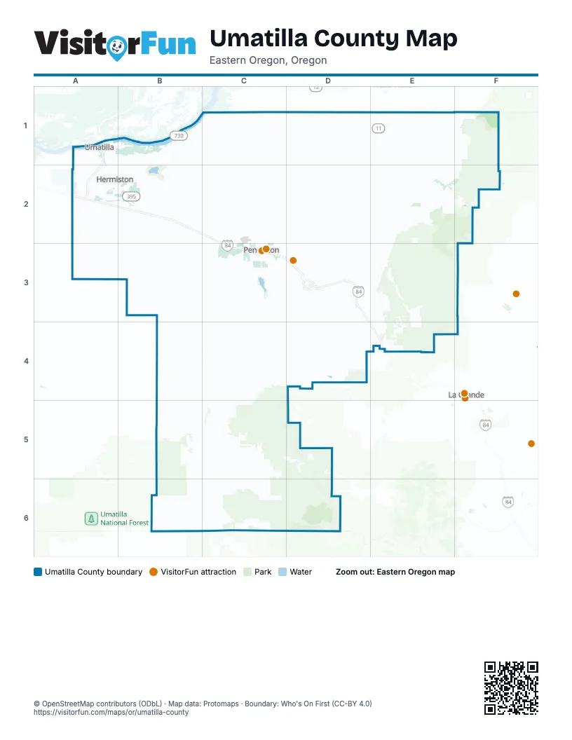
Maps inside Umatilla County
2 maps inside, from the street map of Umatilla County down.
Street index of Umatilla County
Each street on the sheet and the grid squares it crosses.
- Old Oregon Trail HighwayA2, B2, C2, C3, D3, D4, E4
- McNary HighwayA1, A2
- View pointD3
- Vista pointD3
- Pendleton-John Day HighwayC3, B4, C4, B5, C5, B6, C6
- Oregon-Washington HighwayE1, C2, D2, E2, C3
- Columbia River HighwayA1, B1, C1
- Weston-Elgin HighwayD2, E2, F2
- Rieth RoadB2, B3, C3
- Umatilla-Stanfield HighwayA1, A2, B2
- Diagonal RoadB1, B2
- North Main StreetE1, B2, D2, C3
- Umatilla-Mission HighwayD2, D3
- South Main StreetE1, B2, D2, C3
- Butter Creek HighwayA2
- Northwest 11th StreetA2, C3
- WestgateC3
- 6th StreetA1, D2
- Southwest Court AvenueC3
- North 1st StreetA2
- Southeast Court AvenueC3
- East Elm AvenueA2, B2
- West Elm AvenueA2
- Southwest 11th StreetA2, C3
- Southwest Dorion AvenueC3
- Southwest Birch StreetC4
- Southwest Pendleton-John Day HighwayC3
- South Columbia StreetE1
- North Columbia StreetE1
- Northeast Alder StreetC4
- Southwest 20th StreetC3
- Southeast Dorion AvenueC3
- Southwest Birch PlaceC4
- Northwest 2nd StreetA2, C4
- Washington-Oregon HighwayC3
- Northwest Birch StreetC4
- Pendleton Cold Springs HighwayB1, C1, C2, C3
- Ukiah-Hilgard HighwayC5, D5
- Forest Road 52C6, D6
- Athena-Holdman HighwayC2, D2
- Powerline RoadA1, E1, A2
- Holdman RoadC1, C2, D2
- Forest Road 53B5, C5
- Heppner HighwayB4, C4
- Helix HighwayD2
- Sand Hollow RoadD2
- Oregon Trail RoadA2, B2
- South Edwards RoadB1, B2
- Spring Hollow RoadD2
- Big Butter Creek LaneB3, B4
- Airport RoadC2, C3
- Sunnyside-Umapine HighwayD1, E1
- East Punkin Center RoadA2, B2
- Tutuilla Creek RoadC3
- Stateline RoadD1, E1
- Soap Hill RoadC5, C6
- Umatilla River RoadA1, A2
- Mission RoadC3, D3
- Umapine RoadD1
- Old Highway 320B2
- Westland RoadA2
- Freewater HighwayE1
- 3rd StreetA1, D2, D3
- Main StreetD1, D2, C3, D3, C5
- Banister RoadD2
- Bridge RoadA2
- East Main StreetA2, B2, D2, C4
- Columbia StreetA1, D2
- East Highland AvenueA2, B2
- West Highland AvenueA2
- Little Butter Creek RoadA3
- Southwest Frazer AvenueC3
- Pendleton HighwayC3
- Diagonal BoulevardA2, B2
- Northwest Carden AvenueC3
- Thielsen RoadB2
- Southwest Emigrant AvenueC3
- West Hermiston AvenueA2
- North 1st PlaceA2
- McKay DriveC3
- West Highland ExtensionA2
- Lamb StreetE1
- Sunnyside RoadE1
- NorthgateC3
- North Water StreetD2
- Lamb RoadA2
- West Main StreetB2, D2, C4
- Northwest 8th AvenueE1
- Northeast 8th AvenueE1
- South Water StreetD2
- North Thielsen StreetB2
- South Thielsen StreetB2
- East Broadway AvenueE1
- East Gerone StreetB2
- Camas StreetC5
- Wilson StreetA1, D1
- East Commercial StreetD2
- Williamson RoadD2
- Pearson Creek RoadC4, C5, C6
- Wildhorse RoadC2, D2, E2, C3
- Yellow Jacket RoadD1, E1, C4, C5
- Emigrant RoadD3
- Despain Gulch RoadB2, C2
- Skyline RoadF2, E3, F3
- Birch Creek RoadE1, C3, D4
- East Birch Creek RoadC4, D4
- Mount Emily RoadE4, F4
- Bingham RoadD2, E2, D3
- Mud Springs Canyon RoadB3
- Forest Road 32E2, E3, F3
- Log Springs RoadB5, C5
- South Cold Springs RoadB1, C1, C2
- South Juniper Canyon RoadC1, D1
- Texas Bar RoadC6
- Midway RoadC2, D2
- Cayuse RoadD3
- McKay Creek RoadC3, D3, C4, D4
- Albee RoadC5
- Coombs Canyon RoadB3, C3
- Feedville RoadA2, B2
- Tubbs Ranch RoadD2
- Shaw RoadC3, C4
- Vansycle RoadC1, D1, D2
- Hidaway Springs RoadC5
- North Juniper Canyon RoadC1
- South Fork Walla Walla River RoadE1, E2
- Pambrun RoadD2
- Steen RoadE1, D2, E2
- Yoakum RoadB2, C2, B3
- Alkali Canyon RoadB3, B4
- Forest Road 5312B5, B6
- Waterman RoadD1, D2
- North Loop RoadB2
- Butler Grade RoadC1, D1
- Speare Canyon RoadB3
- East Walls RoadB1
- Motanic RoadC3
- Stewart Creek RoadC4
- Circle RoadC3, C4
- Stanfield Meadows RoadA2, B2
- South Market RoadD3
- Barnhart RoadC2, C3
- Spofford RoadE1
- Kings Corner RoadC1, C2
- Fruitvale RoadD1
- Mann RoadD2
- East Loop RoadB2
- Spring Creek RoadC3, E3
- Canal RoadB2
- Cunningham RoadB3
- Lower Dry Creek RoadD1, E1
- Walla Walla River RoadE1
- Old Highway 30D3
- Mac Hoke RoadB3
- North Ott RoadB1, B2
- McKay Creek Frontage RoadC3
- Indian Lake RoadD4
- Holmes RoadC3, D3
- Best RoadC3, D3
- Winesap RoadE1
- Bensel RoadA1, B1
- Old Emigrant Hill Scenic Frontage RoadE4
- Forest Road 5311B5
- Lloyd RoadA2, C3, D3
- Hood RoadE1
- Mill Creek RoadF1
- Echo Meadows RoadB2
- Thorn Hollow RoadD2, D3
- Agnew RoadA2
- Poverty Flat RoadD3
- Telephone Pole RoadE1
- McLean RoadD2
- Cable Creek RoadC5, C6
- Tutuilla Church RoadC3, D3
- County RoadD1, E1
- Craig RoadB1, B2
- Sumac RoadC3, D3
- Forest Road 5507C6, D6
- Edwards RoadD1
- Milton Cemetery RoadE1
- Eastside RoadE1
- West Spearman RoadB1
- Grant RoadE1
- Sunquist RoadD1, E1
- Joy LaneA2, B2
- John Day RoadC5
- Northeast 4th StreetA2, C4
- South 1st StreetA2
- Cooney LaneA1, A2
- Forest Road 230D5
- Tum-A-Lum RoadE1
- Forest Road 5314B5
- West Orchard AvenueA2
- East Theater LaneA2, B2
- Appleton RoadD1, E1
- Southeast 10th StreetB2, C3
- Southwest Hailey AvenueC3
- Southeast 9th StreetB2, C3
- Beach Access RoadA1, B1
- Schroeder RoadC3
- Baxter RoadB2
- Crawford Hollow RoadD2
- Northeast 10th StreetB2
- Southwest Nye AvenueC3
- Fergies RoadC1
- Southeast 4th StreetA2, C3, C4
- Porter RoadC4
- DeVore RoadA1
- College StreetE1, D2, D3
- Southwest 10th StreetA2, C3, C4
- Sherman StreetD2
- West Ballou RoadE1
- West Ferndale RoadE1
- Locust RoadE1
- Hat Rock RoadB1
- Murietta RoadC3
- East Harding AvenueB2
- Pleasant View RoadD1
- East Coe AvenueB2
- Prunedale RoadD1
- Willamette AvenueA1
- Southwest 2nd StreetA2, C3, C4
- North Elizabeth StreetE1
- North Townsend RoadB2
- Sunshine LaneA1, A2
- Patawa RoadC3
- Roxbury RoadA1, B1
- Coombes Canyon RoadC3
- Southwest Houtama RoadC3
- Northwest 10th StreetA2, C3
- Kelli BoulevardB2
- 2nd StreetA1, D2
- C StreetA1, B1, A2
- Hill RoadC5
- West Crockett RoadE1
- Southwest Marshall AvenueC3
- Cedar StreetA2, D3
- Southwest 1st StreetC3
- Southwest 37th StreetC3
- Jones Prairie RoadB6
- Triangle Station RoadD1
- Triangle RoadD1
- Lake DriveC3
- Bud Draper DriveA1, B1
- Northwest Geer RoadA2
- West Punkin Center RoadA2
- Southeast 2nd StreetA2, C3
- Northwest Despain AvenueC3
- Miller RoadE1
- Cobb RoadE1
- Southeast Isaac AvenueC3
- Northwest Cedar StreetC4
- Southeast Frazer AvenueC3
- East Hooker RoadB2
- Paterson Ferry RoadA2
- Southwest Quinney AvenueC3
- Burggraff RoadD1
- Northwest A AvenueC2
- Rencken RoadD1
- Southgate PlaceC3
- Brownell BoulevardA1
- Southwest Ladow AvenueC3
- Southwest 30th StreetC3
- South Elizabeth StreetE1
- Southwest 17th StreetA2, C3
- Southeast 15th StreetC3
- West Harper RoadA2
- Southwest 8th AvenueE1
- Riverside RoadA1
- Southwest 23rd StreetA2, C3
- Stephens RoadD1
- Southeast Nye AvenueC3
- Knight RoadA2
- Forest Road 63F2
- West Theater LaneA2
- LeFore RoadE1
- Southeast Emigrant AvenueC3
- R A Koch RoadC4
- Northeast 5th AvenueE1
- Riverside AvenueA1
- De Haven StreetE1
- Northeast 11th AvenueE1
- Saint Anthony WayC3
- West Locust AvenueA2
- Southwest 13th StreetC3
- West Broadway AvenueE1
- Summit RoadE4
- Ordnance RoadA2
- Northwest 1st AvenueE1
- Southwest 6th AvenueE1
- Southwest 2nd AvenueE1
- Southeast 15th AvenueE1
- Northwest 5th AvenueE1
- Harrison StreetD2
- Turbyne RoadE1
- Southwest Byers AvenueC3
- East Ballou RoadE1
- Madison StreetA1
- Southeast 9th AvenueE1
- East Ferndale RoadE1
Things to do on the Umatilla County map
Places on the map
- Adams
- Athena
- Battle Mountain Forest State Scenic Corridor
- Big River Golf Course
- Blue Mountain Forest State Scenic Corridor
- Cayuse
- Cold Springs National Wildlife Refuge
- Cold Springs Reservoir
- Echo
- Golf Course at Birch Creek
- Gopher Flats
- Hat Rock State Park
- Helix
- Hermiston
- Hermiston Desert Disc Golf
- Hermiston Municipal Airport
- Hinkle Yard
- Hump and Bowl Yard
- Indian Lake
- Kirkpatrick
- Martin Scout Ranch
- McKay Creek National Wildlife Refuge
- McKay Reservoir
- McNary Wildlife Nature Area
- Meacham Divide Nordic Area
- Milton-Freewater
- Mission
- North Fork John Day Wilderness - Tower Unit
- North Fork Umatilla Wilderness
- Pendleton
- Pilot Rock
- Power City Wildlife Area
- Riverside
- Seven Hills
- Southwind
- Stanfield
- Summit View
- Tutuilla
- Ukiah
- Umatilla
Next to Umatilla County
© OpenStreetMap contributors, Open Database License, openstreetmap.org/copyright · Map data: Protomaps · Boundary: Who's On First (CC-BY 4.0); Quattroshapes (CC BY 2.0)















