

Oregon map
Hillsboro map
About 110,337 people live here (Census Bureau, 2024 estimate). The sheet's index lists 300 streets; Northeast Cornell Road, Northeast Evergreen Road and Northeast Century Boulevard cross the most grid squares. Things to do inside the boundary: Cedartree Hotel, Hillsboro Visitor Information Center and Sunset Esplanade.
Open the map (PDF, US Letter)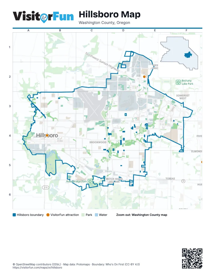
Street index of Hillsboro
Each street on the sheet and the grid squares it crosses.
- Northwest Sunset HighwayD2, E2, E3, F3
- Northeast Cornell RoadC3, D3, E3, F3, B4, C4
- Northeast Brookwood ParkwayD2, C3, D3, C4
- Northeast Evergreen ParkwayD2, D3, E3, F3
- Northeast Cornelius Pass RoadE2, E3, E4
- Southeast Tualatin Valley HighwayB5, C5, D5, E5
- Northeast Evergreen RoadB2, C2, D2, A3, B3
- Northwest 185th AvenueF3, F4
- Southeast Oak StreetB4, C4
- Southeast Cornelius Pass RoadE4, E5
- Northwest Glencoe RoadA3, B3
- Southwest 185th AvenueF4, F5
- Southwest Baseline StreetA4, B4
- Southeast Baseline StreetB4
- Southwest Oak StreetA4, B4
- Southeast 10th AvenueB4, B5
- North 1st AvenueB3, B4
- South 1st AvenueB4, B5
- Southwest Hillsboro HighwayB5
- Southwest Tualatin Valley HighwayA4
- Northwest Cornelius Pass RoadE2
- East Main StreetB4, C4, D4, E4
- Northeast Century BoulevardD1, E1, D2, D3, D4
- Southeast Brookwood AvenueC4, C5, D5, D6
- Northeast 25th AvenueB2, C2, C3, C4
- Northeast John Olsen AvenueE3, E4
- Southeast River RoadB5, C5, C6
- Northeast Walker RoadE3, F3, F4
- Northeast Shute RoadD3
- Northeast Jacobson StreetD2, E2
- Northwest West Union RoadD1, E1, E2
- Northeast Amberglen ParkwayE3, F3, E4
- Northeast Stucki AvenueE3, F3, E4
- Southeast 32nd AvenueC4, C5
- Southeast Minter Bridge RoadB5, C5, B6
- Northeast Wilkins StreetE4
- Southeast Witch Hazel RoadC5, D5
- Northeast 28th AvenueC4
- Southeast Cypress StreetC5
- Northeast Walbridge StreetD3, E3
- West Baseline RoadE4, F4
- Northeast Imbrie DriveD3, E3
- Northwest Helvetia RoadD2
- Northwest Cornell RoadF3
- Northwest Jackson School RoadB3
- Northwest Walker RoadF4
- Northwest 205th AvenueE4
- Southwest Stepping Stone DriveF4
- Southeast Maple StreetB4, C4, D4
- Southeast Walnut StreetB4, C4
- Southeast Century BoulevardD4, D5, D6
- Northeast Lincoln StreetB4, C4
- Northeast Grant StreetB4, C4
- Northeast Jackson School RoadB3, B4
- Northeast Veterans DriveC4
- Northeast Butler StreetD3, E3
- Southeast 67th AvenueD4, D5, D6
- Southeast Alexander StreetC5, D5, C6
- Northeast Cherry DriveD3, D4, E4
- Northeast Elam Young ParkwayD3, D4
- Northwest Connell AvenueA3, A4
- Northeast Aloclek DriveE3
- Southeast Davis RoadC6, D6
- Northeast Sunrise LaneB3, C3
- Southeast 24th AvenueC4, C5
- Northeast Quatama StreetD4, E4
- Northeast Tanasbourne DriveE3, F3
- Southeast Frances StreetD5, E5
- Northeast 15th AvenueB3
- Southeast Imlay AvenueD5
- Northeast 17th AvenueB3, B4
- Northeast 3rd AvenueB3, B4
- Northeast Brogden StreetB4, C4
- Northeast Huffman StreetC2, D2
- Northeast Overlook DriveE3
- Southwest Walnut StreetA4, B4
- Southeast 7th AvenueB4, B5
- Northeast Croeni AvenueE1, E2
- Northeast Dawson Creek DriveD2, D3
- Southeast 18th AvenueB4, C4, B5
- Northeast Wagon DriveD2, E2
- Southeast Bentley StreetC5, D5
- Southeast Johnson StreetD5, E5
- Northeast Arrington RoadB3, B4
- Northeast Town Center DriveF3
- West Main StreetA4, B4
- Northeast 2nd AvenueA3, B3, B4
- Northeast Airport RoadC3, D3
- Northeast Gibbs DriveE4, F4
- Northeast Harewood StreetB3
- Northeast 4th AvenueB3, B4
- Southeast Rood Bridge RoadC5, C6
- Northeast Dogwood StreetD4, E4
- Northeast 30th AvenueC2, C3, C4
- Northeast Hidden Creek DriveD4
- Southwest Dennis AvenueA4
- Northeast Holly StreetF4
- Southeast 12th AvenueB4, B5
- Southeast 3rd AvenueB4
- Southeast 21st AvenueC4, C5
- Southeast 2nd AvenueB4
- Northeast Starr BoulevardC2
- Northeast Venetian DriveE3, F3
- Northeast 106th AvenueF3
- Southeast 5th AvenueB4
- Southeast 13th AvenueB4, B5
- Northeast 37th AvenueC4
- Northeast 53rd AvenueD4
- Southeast Borwick StreetD4, E4
- Northeast Griffin Oaks StreetB3, C3
- Northeast Jones Farm ParkwayB3
- Northeast 5th AvenueB4
- Southeast Golden RoadD5
- Northeast Von Neumann DriveE4
- Northwest Hornecker RoadA3
- Northeast Ronler DriveD3, E3
- Northeast Bennett StreetD2
- Northeast 59th AvenueD2
- Southeast 4th AvenueB4
- Northeast Prahl ParkwayB3
- Northeast 69th AvenueD4
- Southwest Armco AvenueA4, A5
- Northeast 48th AvenueD3
- Northeast Five Oaks DriveE2
- Southeast Edgeway DriveF4
- Northeast Edgeway DriveF4
- Northeast 34th AvenueC3, C4
- Northeast 83rd AvenueE3
- Northeast Parksedge CircleB3
- Northeast Westmark DriveD1, E1
- Southwest Main StreetA4
- Northeast Heritage ParkwayF4
- Southwest 17th AvenueA4
- Northwest Cory StreetA3
- Southeast Blanton RoadD5
- Northeast Elam Young Parkway WestD3
- Southwest Johnson StreetE5
- Southwest Rood Bridge RoadC6
- Northwest Heritage ParkwayF4
- Northwest Bronson RoadF3
- Northeast Elam Young Parkway EastD3
- Northwest Stucki PlaceF3
- Southeast Washington StreetB4
- Southeast Lone Oak StreetC5, D5, D6
- West Garrett DriveD3
- Southeast Cedar StreetB4, C4
- Northeast Kathryn StreetB3, C3
- Northeast 9th AvenueB3, B4
- Northeast Jackson StreetB4, C4
- Southeast Lois StreetD5, E5
- Southeast 73rd AvenueE4, D5, E5
- Southeast Alder StreetB4, B5, C5
- Southeast Spruce StreetB5, C5
- Southeast Pine StreetB5, C5, D5
- Northeast Birch StreetD4, E4
- Southeast 11th AvenueB4, B5
- Northeast 10th AvenueB3, B4
- Southeast 8th AvenueB4, B5
- Southeast Drake StreetD5, E5
- Northeast Azalea StreetC4
- Northwest Colony RoadE4, F4
- Southeast Fir Grove LoopB5
- Southeast 40th AvenueC4, C5
- Northeast 21st AvenueC3, C4
- Northeast Estate DriveB3
- Southeast Meadow Lark DriveC5
- Northwest Jackson StreetA4, B4
- Southeast 37th AvenueC4, C5
- Northwest Airport RoadC3
- Northwest 3rd AvenueA3
- Northeast 14th AvenueB3, B4
- Northeast 12th AvenueB3, B4
- Northwest Garibaldi StreetA4, B4
- Northeast Lenox StreetA3, B3
- Northeast Alder StreetD4, E4
- Hillsboro AirportC3
- Southeast 70th AvenueD4, D5
- Northeast Barberry DriveB3, C3, B4
- Southeast 74th AvenueE4, E5
- Northeast 60th AvenueD3, D4
- Southeast 53rd AvenueD5
- Northeast 62nd AvenueD1, D2, D4
- Northeast Birchwood DriveB4
- Northeast 47th AvenueC4, D4
- Southeast 54th AvenueD4, D5
- Southeast 36th AvenueC4, C5
- Northeast Shaleen StreetE4
- Southeast 30th AvenueC4, C5
- Northeast Thomas StreetB3, C3
- Northeast 6th AvenueB4
- Southeast Gerhard DriveB5, B6, C6
- Northeast 51st AvenueD3
- Northeast Ronler WayD3, E3
- Northwest 2nd AvenueA3, B3, B4
- Southeast Hacienda StreetD5, E5
- Northeast Jamie DriveB3
- Northeast Autumn Rose WayB3
- Northeast Hyde StreetB4, C4
- Northeast 18th AvenueB4, C4
- Northeast Laura StreetC4
- Southeast 6th AvenueB4
- Southeast Clipper LaneB4
- Southeast Rood Bridge DriveC5
- Southeast Singing Woods DriveC6
- Southeast 9th AvenueB4
- Southwest Wood StreetA5, B5
- Southeast Willow DriveC5
- Southeast 72nd AvenueE4, D5, E5
- Southeast Morgan RoadB6, C6
- Northeast Edison StreetB4
- Southeast 39th LoopC5
- Northeast 49th AvenueD4
- Northeast Meadow LaneC4
- Northeast Birchaire LaneB4
- Northeast Alex WayB3
- Southeast Wrenfield StreetD4, E4, D5
- Northwest Forest StreetA4, B4
- Southwest Adams AvenueB4, B5
- Southeast Patterson StreetD5
- Southeast Ariel StreetD4, E4
- Northeast 43rd AvenueC4
- Northeast Hillwood DriveB4
- Northeast 66th AvenueD4
- Northeast 79th AvenueE3, E4
- Southeast 16th AvenueB4, B5
- Northeast 63rd AvenueD3, D4
- Northwest Freeman AvenueA4
- Northeast Rosebay DriveD3
- Southeast 52nd AvenueD5
- Southeast Chance LaneB4
- Northeast Queens LaneB4
- Northeast Rogahn StreetB3
- Northeast 57th AvenueD3, D4
- Northeast Creeksedge DriveB3
- Northeast Sewell AvenueC2, C3
- Northeast Trailwalk DriveE4
- Northwest Darnielle StreetA4
- Southeast Thornapple StreetD6
- Northeast Vinings WayD3
- Northeast Chestnut StreetD4
- Northwest Lincoln StreetA4, B4
- Northwest Adams AvenueB4
- Southeast 68th AvenueD4, D5
- Northeast Farmcrest StreetD3
- Southeast 35th AvenueC4, C5
- Northeast Delsey RoadB3, B4
- Northeast Gateway PlaceF4
- Northwest Atkeson LaneE3
- Northeast Briarcreek WayE4
- Northwest Dennis AvenueA4
- Southeast Drake RoadD5
- Northeast 9th PlaceB3, B4
- Northeast Goldie DriveB3
- Northwest 7th AvenueA3, A4
- Southeast 15th AvenueB4, B5
- Northeast Lindsey DriveB3
- Northeast 24th AvenueC3, C4
- Northeast Oelrich StreetD4
- Northwest 10th AvenueA3, A4
- Southeast 56th AvenueD4, D5
- Southeast Duke DriveB5
- Southeast Bush StreetB5, C5
- Northeast Trisha DriveB3
- Northeast Carlaby WayB3
- Southeast Timberlake DriveC5
- Northeast 58th AvenueD4
- Southeast Tanager CircleB5, C5
- Northeast Compton DriveE3, E4
- Southeast 66th AvenueD4, D5, D6
- Southeast Gumleaf LaneB4
- Northeast Kennedy LaneB3
- Northeast Parkside DriveB3
- Northeast Pubols StreetD1
- Northwest 13th AvenueA4
- Southeast 62nd AvenueD4, D5
- Southeast 60th AvenueD4, D5
- Northeast 55th AvenueD4
- Southeast Jacquelin DriveB5
- Northeast Moda WayE3, F3
- Northeast Hood StreetB3
- Northeast Ray CircleD3, D4
- Northwest Ebberts AvenueA4
- Northeast Copper Beech DriveD3
- Southeast 61st DriveD5
- Southwest Washington StreetA4, B4
- Northeast 68th AvenueD4
- Northeast Tandem WayD3
- North Garrett DriveD3
- Southeast Quail CircleB5, C5
- Northeast 61st AvenueD3, D4
- Northeast Eckert DriveE4, F4
- Northeast 67th AvenueD3, D4
- Northeast Darnielle DriveB4
- Northeast Hawthorne AvenueB3, B4
- Southeast 41st AvenueC4, C5
- Southwest Bailey AvenueA4, A5
- Northeast Orenco Gardens DriveD4
- Northeast Palazza WayE3
- Southeast Blue Bird DriveC5
- Southeast 58th CourtD4, D5
Things to do on the Hillsboro map
Places on the map
- Amberglen
- Amberglen Business Center
- Brookwood Crossing
- Bunch's RV & Boat Storage
- Cornelius Pass Business Park
- Crossroads at Orenco Station
- Dairy Creek Park
- Dawson Creek Business Park
- Dawson Creek Park
- Dawson Creek Woods
- Downtown Hillsboro
- Enschede Estates
- Evergreen Business Park
- Fairgrounds Sports Complex
- Fir Lawn Cemetery
- Five Oaks West Business Park
- Glencoe at Estate Drive
- Gordon Faber Recreation Complex
- Hare Field
- Hawthorn Farm Industrial Park
- Hillsboro High School
- Hillsboro Market Center
- Hillsboro Medical Center
- Jackson School Woods
- Liberty High School
- Minter Bridge Site
- Northern Tier Business Park
- Oak Island Marsh
- Oregon Health & Science University - West Campus
- Orenco
- Orenco Station Town Center
- Orenco Woods Nature Park
- Peterson CAT
- Rock Creek Greenway
- Rood Bridge Park
- Roseway Industrial Park
- Tanasbourne
- Tanasbourne Corporate Center
- Tanasbourne Town Center
- Trellis
Next to Hillsboro
- Elmonica
- Huber
- Somerset West
- Tobias
- Triple Creek
- West Union
© OpenStreetMap contributors, Open Database License, openstreetmap.org/copyright · Map data: Protomaps · Boundary: Who's On First (CC-BY 4.0); Quattroshapes (CC BY 2.0)