

Oregon map
Klamath Falls map
About 22,174 people live here (Census Bureau, 2024 estimate). The sheet's index lists 300 streets; Homedale Road, The Dalles-California Highway and Crater Lake Parkway cross the most grid squares. Things to do inside the boundary: Crater Lake Zipline, Gino's Cafe and Sports Bar and Klamath Art Association Gallery.
Open the map (PDF, US Letter)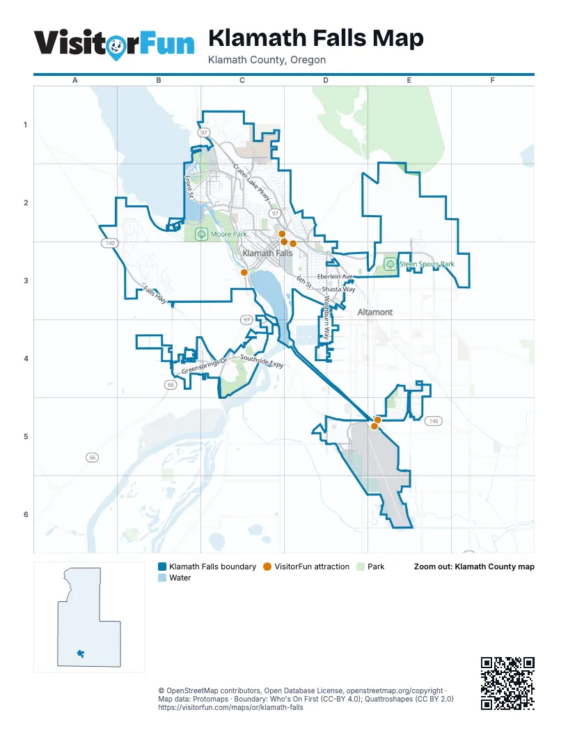
Street index of Klamath Falls
Each street on the sheet and the grid squares it crosses.
- The Dalles-California HighwayC1, C2, C3, C4
- Crater Lake ParkwayC1, C2, D2, D3
- Washburn WayD3, D4, D5
- South 6th StreetC3, D3
- Southside ExpresswayC4, D5, E5
- Falls HighwayA2, A3, B3, C4
- Greensprings DriveC3, B4, C4
- Adams StreetD3
- Foothills BoulevardD3, E3
- Main StreetD2, C3, D3
- Homedale RoadE2, E3, E4, E5, E6
- Lakeshore DriveB2, C2
- Altamont DriveD5
- Shasta WayD3
- Klamath AvenueC3, D3
- Oregon AvenueC2
- Montelius StreetC2
- Airport WayD5
- Upham StreetC2
- Joe Wright RoadD5
- Conger AvenueC3
- Summers LaneE3, E5
- North 9th StreetC2, C3
- Laverne AvenueD4
- Nevada StreetC2
- South 5th StreetC3
- North 11th StreetC2, C3
- Hilyard AvenueD4
- Prospect StreetC2
- South 11th StreetC3
- Patterson StreetE3
- West Main StreetC3
- California AvenueC2, C3
- Lakeport BoulevardC1, C2
- Campus DriveC1, C2
- North Eldorado AvenueC2, D2
- Front StreetB1, B2, C2
- East Main StreetD3
- Eberlein AvenueD3
- Dan O'Brien WayC1
- Balsam DriveB4, C4
- Brett WayD5, E5
- Pine StreetC2, C3
- Hanks StreetB2, C2
- Austin StreetD3, D4
- Biehn StreetC2
- Harbor Isle BoulevardB2, C2
- South Alameda AvenueD3
- North 6th StreetC2, C3
- Esplanade AvenueC2, D2, C3
- Avalon StreetD3
- North 3rd StreetC3
- Cortez StreetC4
- Arnold AvenueD5
- Dahlia StreetC2
- North Laguna StreetD2, D3
- North 7th StreetC2, C3
- Commercial StreetC3
- Riverside DriveC3, C4
- Berkeley StreetC2
- Old Fort RoadD2
- North 5th StreetC3
- South 7th StreetC3
- Harvard StreetC2
- Fairchild AvenueD5
- Orindale RoadB3, B4
- Nosler StreetC2
- South 9th StreetC3
- Crosby AvenueD3
- Torrey StreetC2
- North Spring StreetC2, D2, D3
- Onyx AvenueD4
- South 12th StreetC3
- South 3rd StreetC3
- Spring Lake RoadD5
- Ridgewater BoulevardB2, B3
- Pacific TerraceC2, D2
- Memorial DriveC4
- Vine Maple DriveB3
- Division StreetD3
- Martin StreetD3
- Rustler Peak WayB2, B3
- Haskins AvenueC2, D2
- South Spring StreetC3, D3
- Oak AvenueC3, D3
- Siskiyou StreetC2
- West Oregon AvenueB2, C2
- Loma Linda DriveD2
- Owens StreetD3
- Industrial Park DriveC1
- Paper Birch WayB3
- Bailey Mountain RoadB2, B3
- Mitchell StreetD3
- High StreetC2, C3
- Glenwood DriveE4, E5
- Lincoln StreetC2, C3
- Bryant Williams DriveC1, C2
- Wantland AvenueD3
- West Ridge DriveB3
- Reclamation AvenueD3
- Bartlett AvenueD4, E4
- Delta StreetC2
- Addison StreetC2
- Delap RoadC3, C4
- Abbot Mountain WayB2, B3
- Maywood DriveD3, D4
- Daggett AvenueC1, C2
- Hillside AvenueD2
- Crescent AvenueC2
- New WayC1
- Newcastle AvenueD2
- Orchard AvenueD3
- Vine AvenueD3
- Darrow AvenueD3
- Vandenberg RoadD3
- Douglas AvenueB4, C4
- Beattys Butte DriveB2, B3
- Upland WayE3
- East Lowell StreetC2
- North Alameda AvenueC2
- Worden AvenueC2
- Jefferson StreetC2, C3
- Harmony LaneC2
- Lynnewood BoulevardB2
- North 8th StreetC2, C3
- Market StreetD3
- Ridgecrest DriveC2
- Applegate AvenueD3
- Gatewood DriveE4, E5
- Fulton StreetC2
- Washington StreetC2, C3
- Prescott StreetC2
- South Broad StreetC3
- Dolores AvenueC2, D2
- Sargent AvenueC2
- Portland StreetC2, D2
- Van Ness AvenueC2, D2
- Northhills DriveE3
- Pershing WayD3
- Garden AvenueD3
- White AvenueD3
- Donald StreetC2
- Wade CircleC2
- Lytton StreetC2
- Saddle Butte DriveB2
- Lakeview AvenueC2
- Emerald StreetB4
- North 10th StreetC2, C3
- South Eldorado AvenueD2, D3
- Radcliffe AvenueD3
- North 2nd StreetC3
- College WayC1
- Grant StreetC2, C3
- Roosevelt StreetC2, C3
- Red Willow DriveB3
- Wild Plum DriveB2
- Johnson AvenueC2
- Walnut AvenueC3
- Mountain View BoulevardC2
- Melrose StreetC2, D2
- Broadmore StreetD4
- Alma Alley StreetC2
- North 4th StreetC3
- Manzanita StreetC2, D2
- Pelican StreetC1, C2
- Auburn StreetD2
- Modoc StreetC2
- Mallard LaneC4
- Havencrest DriveE3
- ESI WayC1
- Lewis StreetC3
- Diamond StreetB4
- Cleveland AvenueB4
- Mount Pitt StreetC2
- Vandenberg DriveD5
- Plum AvenueC3
- Fremont StreetC2, D2
- Butte StreetC4
- Quarry StreetC1, C2
- Timer Mountain LaneB3
- Anderson AvenueD4, E4
- North 1st StreetC3
- Glenridge WayE3
- Elm AvenueC3, D3
- Laurelwood DriveE5
- Springcrest WayE3
- Lexington AvenueC2
- Clairmont DriveC2
- McKinley StreetC2, C3
- Leroy StreetC2, D2
- Kennebeck LoopE5
- Lawrence StreetC2, D2
- Huron StreetD2
- Vista WayB2
- Union AvenueD3
- Holabird AvenueC2
- Shelley StreetC2
- Mount Whitney StreetC2, C3
- Basin View DriveE3
- Doty StreetC2
- Hosanna WayE4, E5
- Wesgo DriveD5
- Gage RoadC2
- Corvallis StreetC2
- Richmond StreetD3
- Ankeny StreetE5
- Town Center DriveC1, C2
- Stanford StreetC3
- Buena Vista StreetB2, C2
- South 8th StreetC3
- Lombard DriveE4
- South Rogers StreetC3
- Fairmount StreetD2
- South 4th StreetC3
- Hawthorne StreetC2
- Arrowhead RoadB2, B3
- Wilford AvenueC2
- Michigan AvenueD2, D3
- Saint Francis StreetC2
- Uerlings StreetC2, C3
- Mill StreetC3
- Wall StreetC2, D2
- Harper RowD5
- Northern Heights BoulevardC1
- Timber Ridge LoopB3
- Hawkins StreetB2
- Kellal LaneE5
- Westview DriveE3
- Painter StreetC2, D2
- Almond StreetC1, C2
- Lookout AvenueC2
- Ponderosa DriveB2, B3
- Pleasant AvenueC2
- Bella Vista LoopD2
- Church Hill DriveE3
- Del Moro StreetC2, D2
- Lake Ridge CourtB2, C2
- Chantal AvenueC2
- American AvenueE5
- Euclid AvenueC2, D2
- Sturdivant AvenueE4
- Harbor View DriveC1
- McConnell CircleD5
- Van Camp StreetC2
- Earle StreetC2, D2
- Braynt Butte LoopB3
- Buck Island DriveB2
- Regency DriveE4, E5
- Calhoun StreetC2
- Applewood StreetD3
- Timbermill DriveC3
- Winterfield WayE4
- Benchwood AvenueE2
- Summerfield WayE4
- Primrose LaneB4
- Orange Blossom DriveB3
- Linda Vista DriveD2
- Carlyle StreetC2
- Fountain AvenueC4
- George Nurse WayC3
- Skyridge DriveE2
- Fairway DriveC4
- Home AvenueD3
- Acosta AvenueC2
- Bismark StreetB2
- Red Bud DriveB3
- Erie StreetD2
- Lyptus LaneB3
- Coli AvenueC1
- Cook StreetC2
- Trinity StreetC2
- Liberty AvenueE5
- Redfern LaneE5
- Valleywood DriveE5
- Park AvenueC2, D2
- Benson AvenueC2, D2
- Harbor Vista BoulevardC1
- Knightwood DriveE5
- Sloan StreetC2
- Academy AvenueC2
- Merryman DriveD3
- Adelaide AvenueD3, E3
- McCourt StreetC2
- Eastwood DriveE5
- Hillman Peak LoopB3
- Thrall StreetC2
- Cypress AvenueC3
- Century DriveC1
- Cregan AvenueB4
- Travis WayE4
- Garden CircleC2
- Rickenbacker AvenueC1
- Granite StreetB4
- Upland DriveE3
- Iowa StreetC2
- Willow AvenueC3
- Southview DriveE5
- Stinson WayD5
- Kiln StreetC2
- Wocus StreetB2, C2
Things to do on the Klamath Falls map
Places on the map
- Abby's
- Alert Hangar
- American Legion Hall
- Americas Best Value Inn
- Arboretum
- Arby's
- Arielle A Metz MD FACOG
- Aspen Dental
- Athletics
- Conger Heights Park
- Conger School Park
- Crater Lake Klamath Regional Airport
- Eulalona Park
- Fred Meyer
- Harbor Links Golf Course
- Henderson Park
- Kingsley Field Air National Guard Base
- Klamath Christian Center
- Klamath Falls Town Center
- Klamath Memorial Park
- Klamath Union High School
- Lake Ewauna
- Link River
- Linkville Cemetery
- Love's Travel Stop
- Loyd De Lap Law Library
- Moore Park
- Ontime Pack and Ship
- Oregon Institute of Technology
- Pilot Travel Center
- Ponderosa Middle School
- Reames Golf and Country Club
- Sky Lakes Medical Center
- Southside Park
- Steen Sports Park
- Veterans Memorial Park
- Walmart Supercenter
- Warford Park
- Wright Field
- YMCA
Next to Klamath Falls
- Altamont
© OpenStreetMap contributors, Open Database License, openstreetmap.org/copyright · Map data: Protomaps · Boundary: Who's On First (CC-BY 4.0); Quattroshapes (CC BY 2.0)















