

Oregon map
Klamath County map
About 70,438 people live here (Census Bureau, 2024 estimate). The sheet's index lists 300 streets; The Dalles-California Highway, Klamath Falls-Lakeview Highway and Main Street cross the most grid squares. Things to do inside the boundary: Chiloquin, Crater Lake National Park and Crater Lake Trolley.
Open the map (PDF, US Letter)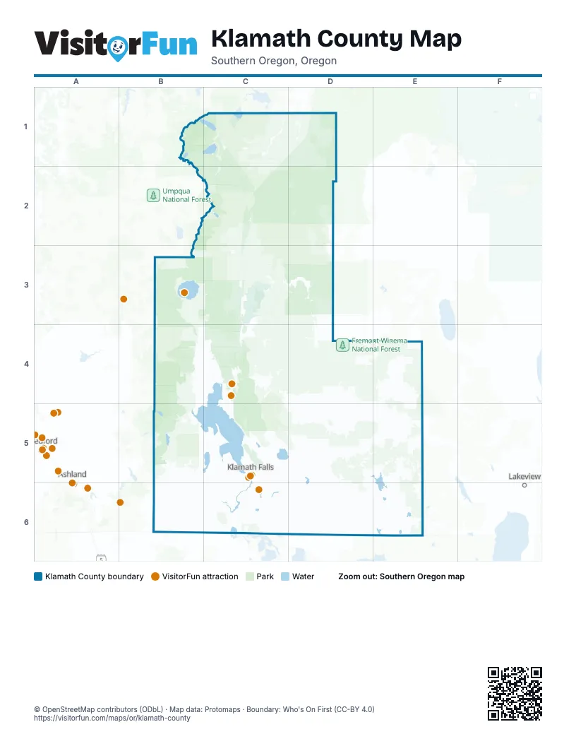
Street index of Klamath County
Each street on the sheet and the grid squares it crosses.
- The Dalles-California HighwayC1, D1, C2, C3, C4, C5, C6
- Klamath Falls-Lakeview HighwayC5, D5, E5, C6
- Falls HighwayB5, C5, C6
- Green Springs HighwayB6, C6
- Klamath Falls-Malin HighwayC6, D6
- Clover Creek RoadB5, C5, C6
- Fremont HighwayD1
- State Highway 58B1, C1, C2
- Crescent Cutoff RoadC1
- Williamette HighwayC1, C2
- Dead Indian Memorial RoadB5
- East Diamond Lake HighwayB3, C3
- Crater Lake ParkwayC5
- State Highway 138C3
- Southside ExpresswayC6
- Dairy-Bonanza HighwayD5
- South 6th StreetC5, C6
- Washburn WayC5, C6
- Greensprings DriveC5, C6
- Hatfield HighwayD6
- Klamath Falls-Malin Highway No. 50D6
- East Front StreetC6
- Adams StreetC5
- West Front StreetC6
- Lava Beds HighwayD6
- Crater Lake HighwayB3, B4, C4
- Silver Lake RoadC3, D3
- Sprague River RoadC4, D4, D5
- Rim DriveB3, D5
- Harpold RoadD6
- Westside RoadB4, B5
- Lower Klamath Lake RoadC6
- State Line RoadC6, D6
- Homedale RoadC5, C6
- Cascade Lakes HighwayC1
- Crater Lake Highway NorthB3
- Bly Mountain Cutoff RoadD5
- Weed Road EastC4
- Old Midland RoadC6
- West Rim DriveB3
- Sevenmile RoadB4, C4
- Lakeshore DriveC5
- Chiloquin HighwayC4
- Munson Valley RoadB3
- Main StreetC1, C5, D5, D6
- Summers LaneC5, C6
- Merrill Pit RoadC6
- Shasta WayC5
- Altamont DriveC5, C6
- Joe Wright RoadC6
- Foothills BoulevardC5
- Hilyard AvenueC6
- Patterson StreetC5, C6
- South Merrill RoadC6
- Laverne AvenueC6
- West Side RoadB4, B5
- Loosley RoadC4
- Market StreetC5, D5, D6
- Chiloquin BoulevardC4
- North StreetD5, D6
- South Malin RoadD6
- 4th StreetC1, C4, D6
- Klamath AvenueC5
- Oregon AvenueC5
- Montelius StreetC5
- Airport WayC6
- Upham StreetC5
- Conger AvenueC5
- North 9th StreetC5
- Chocktoot StreetC4
- Linden StreetC6
- Nevada StreetC5
- South 5th StreetC5
- North 11th StreetC5
- North 1st AvenueC4
- Carroll AvenueD5, D6
- Rush StreetD6
- Broadway StreetD6
- Harpold AvenueD6
- Prospect StreetC5
- South 11th StreetC5
- West Main StreetC5
- South Main StreetC6
- Williamson River RoadD3, C4, D4
- National Forest Development Road 3752E5, E6
- Keno Springs RoadD5, E5
- National Forest Development Road 2415D1, D2
- Sun Mountain RoadC3, C4
- National Forest Development Road 9775C1, D1, C2, C3
- National Forest Development Road 94C2, D2
- East Langell Valley RoadD6
- National Forest Development Road 49C3, D3
- National Forest Development Road 86C2, C3, D3
- Bliss RoadD5
- West Langell Valley RoadD6
- Keno Access RoadB5, B6
- Forest Road 30E4
- East Rim DriveB3
- Willow Valley RoadD6, E6
- Fish Hole Creek RoadE5
- Swan Lake RoadC5
- Forest Road 27D4, E4
- Hill RoadD4, C6, D6
- Forest Road 3462D4, E4
- Military Crossing RoadC3
- Ringo RoadC1, D1
- Gerber RoadD5, E5, D6
- Drews RoadD5
- Modoc Point RoadC4, C5
- National Forest Development Road 5825C2, D5
- Ivory Pine RoadE4, E5
- Miller Lake RoadC2
- National Forest Development Road 46D4
- Crescent Lake HighwayC1, B2, C2
- National Forest Development Road 2516D1, D2
- Old Fort RoadC5
- South Poe Valley RoadC6, D6
- Crescent Lake RoadB1, C1
- Campbell RoadE5
- North Poe Valley RoadC6, D6
- National Forest Development Road 348E5
- Wocus RoadC3, C5
- Keno Worden RoadC6
- Township RoadC6
- Cross RoadC6
- Round Lake RoadC5, C6
- Reeder RoadC6
- Balsam DriveC6
- National Forest Development Road 3661B5
- Rocky Point RoadB4, B5
- Spring Lake RoadC6
- Cheyne RoadC6
- Forest Road 6020C1
- Godowa Springs RoadD4
- Haskins RoadD5, D6
- Godow Spring RoadD4, D5
- National Forest Development Road 375E6
- BLM Road 41-4E-1E5, E6
- Sprague River DriveD4, D5
- Lone Pine RoadC4
- Anderson RoadC6, D6
- Burgdorf RoadD5, D6
- Teare LaneD6
- Tingley LaneC6
- Schaupp RoadD6
- National Forest Development Road 3814E5
- South Chiloquin RoadC4
- Forest Road 6015C1
- Miller Island RoadC6
- Dodds Hollow RoadD6
- Spencer Creek RoadB5
- Crystal Springs RoadC6
- Coopers Hawk RoadC5
- Nicholson RoadB4, C4
- Algoma RoadC5
- Forest Road 28E4
- National Forest Development Road 48N08E6
- Westside Summer Homes RoadB5
- Transformer RoadD6
- West Boundary RoadC3
- Gale RoadD6
- Drazil RoadD6
- Paygr RoadD6
- California AvenueC5, D6
- BLM Road 39-14E-E6
- Micka RoadD6
- Beal RoadD1
- Pine Grove RoadC6
- Taylor RoadC6, D6
- Two Rivers RoadC2
- Malone RoadD6
- National Forest Development Road 3840E5
- National Forest Development Road 22D1
- Buesing RoadC6
- Yonna DriveD5
- Shady Pine RoadC5
- Hackler RoadB4
- Eagle Ridge RoadC5
- Rajnus RoadD6
- Casebeer RoadD5, D6
- West Bay RoadB1
- Hope StreetC5, C6
- Del Fatti LaneC6
- Bisbee StreetC5, C6
- Lakeport BoulevardC5
- Morelock RoadD6
- Matney WayC6
- Oconner RoadC6
- Malin Loop RoadD6
- Madison StreetC5, C6
- Onyx AvenueC6
- Pickett RoadD6
- North Malin RoadD6
- Dehlinger LaneC6
- Austin StreetC5, C6
- Gift RoadD6
- Bristol AvenueC6
- Old Malin HighwayD6
- Brett WayC6
- Crest StreetC5, C6
- Gerber Ranch RoadE5
- Dixon RoadC4
- Front StreetC5, D6
- Orindale RoadC5, C6
- Day School RoadC5
- Campus DriveC5
- Evans RoadD6
- Matney RoadC6
- Harlan DriveC6
- Stastny RoadD6
- Wagon Trail RoadC1
- North Eldorado AvenueC5
- Eberlein AvenueC5
- Anderson AvenueC6
- Wilson RoadD6
- Avalon StreetC5, C6
- Chin RoadC6
- Gaines RoadD6
- Adams Point RoadD6
- Midland HighwayC6
- Adams Point Road EastD6
- Riverside DriveC5
- Henley RoadC6
- Falvey RoadC6
- East Main StreetC5
- Suty RoadD6
- Keller RoadC6
- Edler StreetE5
- Mc Culley RoadD6
- Airway DriveC6
- Dan O'Brien WayC5
- Wu RoadD5
- Short RoadC6
- Crosby AvenueC5
- Holl RoadD6
- Wong RoadC6
- South Alameda AvenueC5
- Boardman AvenueC5
- Pine StreetC5
- Derby StreetC5, C6
- Climax AvenueC5
- Denver AvenueC6
- Delaware AvenueC5
- Kimberly DriveC5
- Pine Crest DriveE5
- 6th StreetC1, D5, D6
- Hanks StreetC5
- 5825 RoadC2
- Callahan RoadD5
- Etna StreetC5
- Clinton AvenueC6
- Jones RoadD6
- Cheese Factory RoadD6
- Running Y RoadC5
- Biehn StreetC5
- Fugate RoadC6
- Harbor Isle BoulevardC5
- Gilchrist State Forest AccessC1
- South 2nd AvenueC4
- North 6th StreetC5
- Esplanade AvenueC5
- Peck DriveC5, C6
- La Marada WayC6
- Timpanogas RoadB1
- North 3rd StreetC5
- Cortez StreetC6
- Arnold AvenueC6
- Walton DriveC6
- Dahlia StreetC5
- North Laguna StreetC5
- North 7th StreetC5
- Commercial StreetC5
- Puckett RoadC6
- Berkeley StreetC5
- North Main StreetC6
- North 5th StreetC5
- South 7th StreetC5
- Harvard StreetC5
- Fairchild AvenueC6
- Nosler StreetC5
- National Forest Development Road 3650B5
- Anderson WayC6
- Potter StreetC1
- South 9th StreetC5
- Torrey StreetC5
- North Spring StreetC5
- South 1st AvenueC4
- Miller Hill RoadC6
- Ward StreetC1
- Oxbow StreetC6
- Springlake RoadC6
- South 12th StreetC5
- South 3rd StreetC5
- National Forest Development Road 44C4, D4
- Kirk RoadC3, D3, C4
- National Forest Development Road 88C2, D2
- Forest Road 22C4, C5, D5
- National Forest Development Road 9407D1, C2, D2
- National Forest Development Road 4582D3, D4
- Forest Road 9718C5
Things to do on the Klamath County map
Places on the map
- Agency Lake
- Alkali Lake
- Altamont
- Antelope Reservoir
- Aspen Lake
- Ball Bay
- Bear Valley National Wildlife Refuge
- Big Adobe Reservoir
- Big Marsh
- Big Meadows
- Bingham Lakes
- Black Rock Lava
- Bonanza
- Buck Lake
- Buckmaster Flat
- Campbell Reservoir
- Chemult Pumice Mine
- Cherry Glade
- Chiloquin
- Chiloquin State Airport
- Collier Memorial State Park
- Conger Heights Park
- Copeland Reservoir
- Crater Lake
- Crater Lake National Park
- Crescent Lake
- Davis Lake
- Desolation Swamp
- DeVaul Lake
- Devil Lake
- Devil's Garden
- Diamond Peak Wilderness
- Dog Hollow Reservoir
- Fremont-Winema National Forest
- Gilchrist State Forest
- Klamath Marsh National Wildlife Refuge
- Mount Thielsen Wilderness
- Mountain Lakes Wilderness
- Sky Lakes Wilderness
- Upper Klamath National Wildlife Refuge
Next to Klamath County
- Ashland
- Lakeview
- Medford map
© OpenStreetMap contributors, Open Database License, openstreetmap.org/copyright · Map data: Protomaps · Boundary: Who's On First (CC-BY 4.0); Quattroshapes (CC BY 2.0)