

Oregon map
Lebanon map
About 19,950 people live here (Census Bureau, 2024 estimate). The sheet's index lists 300 streets; Twelfth Street, Tenth Street and Fifth Street cross the most grid squares. Also on it: Cheadle Lake, Cheadle Lake Park and Gills Landing.
Open the map (PDF, US Letter)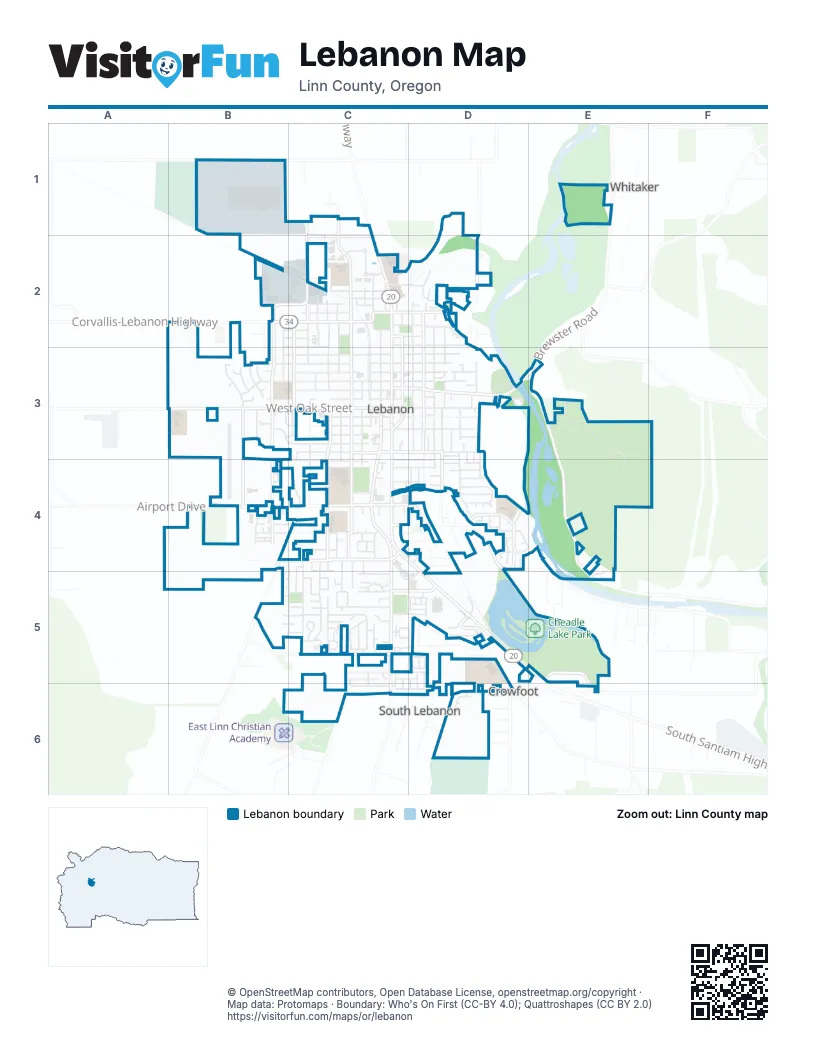
Street index of Lebanon
Each street on the sheet and the grid squares it crosses.
- Gore Drive SoutheastB1
- Millview WayB1
- Fifth StreetC1, C2, C3, C4
- Hansard AvenueC1, C2
- Corvallis-Lebanon HighwayB2
- Eleventh StreetB2, B3, C4, C5
- Harrison StreetB2, C2
- Sunset RoadB2, B3
- Tangent StreetB2, C2
- Twelfth StreetB2, B3, B4, C4, B5, C5
- West Academy StreetB2, C2
- West Carolina StreetB2, C2
- West Isabella StreetB2, C2
- Academy StreetC2
- Boulder Falls DriveC2
- East Carolina StreetC2, D2
- East Dodge StreetC2, D2
- East Isabella StreetC2, D2
- Eaton StreetC2
- Eighth StreetC2, C3, C4, C5
- Fourth StreetC2, C3, C4
- Industrial WayC2, D2
- Laurel StreetC2
- Main StreetC2
- Morton PlaceC2
- Mullins DriveC2
- Ninth StreetC2, C3, C4, C5
- North Main StreetC2
- Park StreetC2, C3
- Reeves ParkwayC2
- Santiam HighwayC2
- Second StreetC2, C3, C4
- Seventh StreetC2, C3, C4, C5
- Sixth StreetC2, C3, C4
- South Main StreetC2, C3, C4
- South Second StreetC2, C3
- Tenth StreetC2, B3, C3, C4, C5
- Third StreetC2, C3, C4
- Twin Oaks AvenueC2
- West Mary StreetC2
- West Morton StreetC2
- West Olive StreetC2
- Wheeler StreetC2, D2
- Beaton LaneD2
- Bromil StreetD2
- Cleveland StreetD2, D3
- East Olive StreetD2
- Edgewater SquareD2
- Grove StreetD2, D3, D4
- Hiatt StreetD2, D3, D4
- Kearn StreetD2
- North Grove StreetD2
- North Williams StreetD2
- Oneil StreetD2
- South Santiam StreetD2
- South Williams StreetD2, D3
- Tennessee Road SoutheastD2
- Wheeler LoopD2
- WilliamsD2
- Airway PlaceB3
- Ashwood CourtB3
- B LoopB3, C3
- Fifteenth StreetB3
- Fourteenth StreetB3
- Gilbert DriveB3
- Maple PlaceB3
- Montessa WayB3
- Sixteenth PlaceB3
- Sixteenth StreetB3
- Thirteenth StreetB3
- Vine StreetB3
- West Airway RoadB3, B4
- West Ash PlaceB3
- West D StreetB3, C3
- West Grant PlaceB3
- West Maple StreetB3, C3
- West Oak StreetB3, C3
- West Rose StreetB3, C3
- West Sherman StreetB3, C3
- West Vine StreetB3, C3
- E StreetC3
- East Ash StreetC3, D3
- East Elmore StreetC3, D3
- East Grant StreetC3, D3, E3
- East Maple StreetC3, D3
- East Milton StreetC3, D3
- East Oak StreetC3, D3
- East Rose StreetC3, D3
- East Sherman StreetC3, D3
- East Vine StreetC3, D3
- School LaneC3
- South Park StreetC3
- West A StreetC3
- West Ash StreetC3
- West B StreetC3
- West C StreetC3
- West E StreetC3
- West Elmore StreetC3
- West Grant StreetC3
- Brewster RoadD3, E3
- Carlson DriveD3
- Chestnut CourtD3
- Crescent StreetD3
- David DriveD3, D4
- Downing DriveD3, D4
- East A StreetD3
- Eddie StreetD3
- Filbert StreetD3
- Franklin StreetD3, D4
- Harden DriveD3
- Harmony StreetD3
- Kimber CourtD3
- Mayer DriveD3
- Park DriveD3, D4
- Post StreetD3, D4
- River StreetD3
- Walnut StreetD3
- Berlin RoadE3, E4, E5
- Ridgeway DriveE3, E4
- Airport DriveB4
- Antioch StreetB4
- Chelsea WayB4
- Corinth CourtB4
- Cypress CourtB4
- Dover CourtB4
- F StreetB4, C4
- Kees StreetB4, C4
- Leonard LaneB4
- Oxford CourtB4
- Oxford StreetB4
- South Airport RoadB4, C4
- Stoltz Hill RoadB4, C4, B5
- Turtledove LoopB4
- Victoria CourtB4
- Victoria StreetB4
- Walker RoadB4, C4
- Acorn StreetC4, C5
- Airport RoadC4
- Alder StreetC4
- Berry StreetC4, D4
- Birch StreetC4, C5
- Cooper StreetC4
- Cox StreetC4
- Dewey StreetC4
- Division WayC4, C5, D5
- East Airport RoadC4, D4
- East Cedar StreetC4
- East Pine StreetC4, D4
- Fourth PlaceC4
- H StreetC4
- Hemlock StreetC4
- J StreetC4
- Jennings StreetC4, D4
- Kelm PlaceC4
- Larson LaneC4
- Manor WayC4, C5
- Omire LaneC4
- Primrose StreetC4
- Russell DriveC4, D4
- South Arlene AvenueC4, C5
- South MainC4
- South Main RoadC4, C5
- South Santiam HighwayC4, D4, D5
- Strawberry LaneC4
- Taylor StreetC4
- Third PlaceC4
- Wassom StreetC4
- Wendell StreetC4
- Binshadler StreetD4
- Carroll StreetD4
- Channel StreetD4
- Desiree PlaceD4
- Evans DriveD4
- Falcon CourtD4
- Garvord StreetD4
- Gleanns WayD4
- Glen Oak DriveD4
- Glenwood StreetD4
- Janna CourtD4
- Jaquline PlaceD4
- Jason PlaceD4
- Koi LaneD4
- Kokanee WayD4
- Lydia LaneD4
- Mayfly StreetD4
- McKinney LaneD4
- Mickie DriveD4
- Mountain River DriveD4
- Osprey WayD4
- Parkway StreetD4
- Ralston DriveD4
- Randall DriveD4
- Redband WayD4
- River DriveD4
- Robbins CourtD4
- Robbins WayD4, E4
- Roll Tide CourtD4
- Russell StreetD4
- Steelhead CourtD4
- Streamside WayD4
- Tasha WayD4
- Water's Edge CourtD4
- Charlie AvenueB5, C5
- Elizabeth PlaceB5, C5
- Jody PlaceB5, C5
- Mazama AvenueB5, C5
- Molly PlaceB5, C5
- Angelee CourtC5
- Aspen LaneC5
- Aspen StreetC5
- Azalea StreetC5
- Big Brother LaneC5
- Bluebird PlaceC5
- Camellia DriveC5, D5
- Cedar LaneC5
- Cherry Blossom LaneC5
- Cherry CourtC5
- Chucker LaneC5
- Columbine StreetC5
- Cottontail PlaceC5
- DogwoodC5
- Dorothy DriveC5
- Dove StreetC5
- Duck PlaceC5
- East Joy StreetC5, D5
- EastviewC5
- Elm CourtC5
- Foxglove StreetC5
- Foxtail LoopC5
- Galena LoopC5
- Hazel DriveC5
- Hobbs StreetC5
- Honeysuckle StreetC5
- Juniper WayC5
- Kari PlaceC5
- Kingdom DriveC5, C6
- Larkspur StreetC5
- Liberty LaneC5
- Lindsay LaneC5
- Lupine StreetC5
- Mallard DriveC5
- Market StreetC5, D5
- Meadowlark DriveC5
- Northwest Sequoia AvenueC5
- Oak Terrace DriveC5, D5
- Oak WayC5, D5
- Pheasant RunC5
- Quail PlaceC5
- Red Arrow DriveC5, C6
- Redwood AvenueC5
- Rhododendron StreetC5
- Rooster LaneC5
- Rose DriveC5
- Sand Ridge CourtC5
- Seventh PlaceC5
- Shannon PlaceC5
- Snow Bird DriveC5, C6
- Snow Peak PlaceC5
- South Place WayC5
- Southwest 5th StreetC5, C6
- Spruce AvenueC5
- Sugarberry LaneC5
- Sunflower LaneC5
- Trillium PlaceC5
- Vaughn LaneC5
- Violet StreetC5
- Wagon Wheel DriveC5, D5
- Weldwood DriveC5, D5
- West Cedar DriveC5
- West Jadon DriveC5, C6
- West Joy StreetC5
- Willow DriveC5
- Bald Eagle DriveD5, D6
- BrookhavenD5
- Burdell BoulevardD5
- Cascade DriveD5
- Cascade MeadowsD5
- ChampionD5
- Chinook CourtD5
- Creek SideD5
- Elk RunD5
- Gilbert StreetD5
- GreenbriarD5
- Hawk Arrow DriveD5, D6
- Meadowlark LaneD5
- Red Tail DriveD5, D6
- Santiam Village ParkwayD5
- Stone MistD5
- Swallow Tail LoopD5
- Truman StreetD5
- Weirich DriveE5
- East Jadon DriveC6, D6
- Baker StreetD6
- Central AvenueD6
- Crowfoot RoadD6
- Elderberry DriveD6
- Hermans DrD6
- Minnesota StreetD6
- Triangle CtD6
- View LaneD6
Places on the map
- Academy Square
- Best Western Premier Boulder Falls Inn
- Bob Smith Memorial Park
- Booth Park
- Boulder Falls Center
- Central Willamette Community Credit Union
- Century Park
- Cheadle Lake
- Cheadle Lake Park
- Christopher Columbus Park
- Community BIble Church
- Fire Station 31
- Gills Landing
- Green Acres Elementary School
- Grocery Outlet
- Kingdom Hall of Jehovah's Witnesses
- Kuhn Cinema
- Lebanon Fire Station 34
- Lebanon First Assembly of God
- Lebanon High School
- Lebanon High School Fields
- Lebanon Pioneer Cemetery
- Lebanon Police Department
- Lebanon Post Office
- Lebanon Public Library
- Lebanon Skate Park
- Lebanon State Airport
- O'Reilly Auto Parts
- Oregon mini Mart
- Oregon Veterans Home "Alpha"
- Oregon Veterans Home "Bravo"
- Oregon Veterans Home "Charlie"
- Oregon Veterans Home "Delta"
- Pioneer School
- River Park
- Riverview School
- Samaritan Lebanon Community Hospital
- Seven Oak Middle School
- The UPS Store
- Walmart Supercenter
Next to Lebanon
- Crowfoot
- South Lebanon
- Whitaker
© OpenStreetMap contributors, Open Database License, openstreetmap.org/copyright · Map data: Protomaps · Boundary: Who's On First (CC-BY 4.0); Quattroshapes (CC BY 2.0)















