

Oregon map
Linn County map
About 132,474 people live here (Census Bureau, 2024 estimate). The sheet's index lists 300 streets; Santiam Highway, North Santiam Highway and Main Street cross the most grid squares. Things to do inside the boundary: Albany, Albany Historic Carousel and Museum and Gallery Calapooia.
Open the map (PDF, US Letter)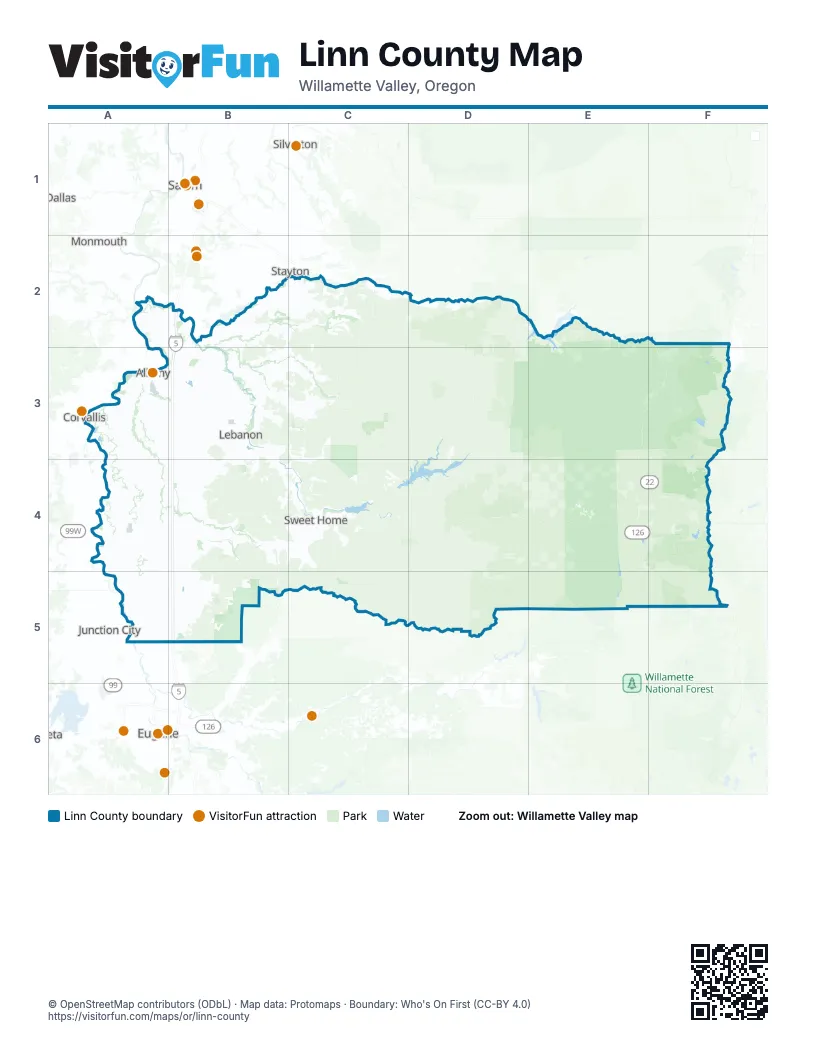
Maps inside Linn County
2 maps inside, from the street map of Linn County down.
Street index of Linn County
Each street on the sheet and the grid squares it crosses.
- Highway #001MR - Santiam Highway Connection #1B3
- Highway #001NK - Viewcrest Connection #2B2
- Highway #001MT - Santiam Highway Connection #3B3
- Highway #001NL - Viewcrest Connection #3B2
- Highway #001MY - North Albany Connection #3B3
- Highway #001NA - Century Drive Frontage RoadB2
- Highway #001MU - Santiam Highway Connection #4B3
- Highway #001MS - Santiam Highway Connection #2B3
- Highway #001MW - North Albany Connection #1B3
- Santiam HighwayB3, B4, C4, D4, E4, F4
- Albany-Lyons HighwayB2, C2, B3
- Albany-Junction City HighwayA3, B3, A4, A5
- North Santiam HighwayF2, E3, F3, E4, F4
- Halsey-Sweet Home HighwayA4, B4, C4
- Corvallis-Lebanon HighwayA3, B3
- Clear Lake-Belknap Springs HighwayE4, E5
- Diamond Hill RoadA5, B5
- Main StreetC2, B3, A4, B4, C4
- Brush Creek RoadB4, B5
- Stayton Scio Road SoutheastB2, C2
- Pacific Boulevard SouthwestA3
- Highway 34 SoutheastB3
- South Santiam HighwayB3
- Santiam Highway SoutheastA3, B3
- Denny School RoadB3
- Jefferson HighwayB2
- McFarland RoadA3
- Pacific Boulevard SoutheastA3, B3
- South Main StreetB2, B3
- Stayton Scio RoadB2
- 9th Avenue SoutheastA3
- Airport DriveB3
- North Main StreetB2, B3, B4
- Airport RoadB3, C4
- West 2nd StreetA4
- Territorial StreetA5
- Tangent StreetB3
- Park StreetB3, A4, B4, C4
- Albany-Corvallis HighwayA3
- North 7th StreetA5
- South 1st AvenueC2, D2
- Newport-Corvallis HighwayA3
- South Airport RoadB3
- West Bishop WayB4
- Ellsworth Street Southwest / Albany-Corvallis HighwayA3
- Lyon Street South / Albany-Corvallis HighwayA3
- Bishop WayB4
- Holley RoadC4
- West Holley RoadC4
- South Park StreetB3
- South 3rd StreetA5
- East Carolina StreetB3
- Highway 99EA5
- Northwest Harrison BoulevardA3
- Northwest Van Buren AvenueA3
- Highway 228B4
- Northeast 4th AvenueB2
- Corvallis-Newport HighwayA3
- 9th Avenue Southwest / Albany-Corvallis HighwayA3
- Ellsworth Street SouthwestA3
- Marcola RoadB5
- Ellsworth Street Northwest / Albany-Corvallis HighwayA3
- Peoria RoadA3, A4, A5
- Berlin RoadB3, C3, C4
- Ridge DriveB2, C2, A3, B3
- Seven Mile LaneA3, B3, B4
- Lake Creek DriveA4, B4
- Richardson Gap RoadB2, B3
- Oakville Road SouthwestA3
- Kingston Jordan RoadC2
- Brownsville RoadB4
- Brewster RoadB3
- Sandridge RoadB3, B4
- Lacomb DriveB3, C3
- Jefferson-Scio DriveB2
- Knox Butte Road EastB3
- Pleasant Valley RoadC4
- Rockhill DriveB3, B4
- American DriveA4
- Scravel Hill Road NortheastB2, B3
- Tangent DriveA3, B3
- River DriveB3, B4
- Bellinger Scale RoadC3
- Spicer Drive SoutheastB3
- Coburg RoadA5
- Columbus Street SoutheastA3
- Linn West DriveA4, B4
- East Lyons Mill City DriveC2, D2
- Baptist Church DriveB3, C3
- Old Salem Road NortheastB2, B3
- Century Drive NortheastB2, B3
- Kamph Drive NortheastB3
- Seven Mile Lane SoutheastB3
- Grand Prairie Road SoutheastA3, B3
- Waverly Drive SoutheastA3
- Cole School RoadB2
- Three Lakes Road SoutheastB3
- Spicer DriveB3
- Harrison RoadB4
- Southeast Peoria RoadA3
- Fifth StreetB3
- Geary Street SoutheastA3
- Peoria Road SouthwestA3
- West Oak StreetB3
- Church RoadA3
- Harvest Drive SouthwestA3
- Twelfth StreetB3
- Montgomery DriveB3
- South Main RoadB3, B4
- Falk RoadA4
- Waterloo RoadB3, B4
- Sodaville Cut Off DriveB4
- Queen Avenue SouthwestA3
- Sodaville Waterloo DriveB4
- Main Street SoutheastA3
- Second StreetB3
- Sodaville RoadB3, B4
- Salem Avenue SoutheastA3, B3
- Queen Avenue SoutheastA3
- Goldfish Farm Road SoutheastB3
- 34th Avenue SoutheastA3
- 1st Avenue EastA3
- East Grant StreetB3
- 2nd Avenue SoutheastA3
- 5th StreetC2, B4
- Crowfoot RoadB3
- Lyons Mill City DriveD2
- Tangent Drive SoutheastB3
- Kowitz RoadC3
- Murder Creek Drive NortheastB3
- Walker RoadB3
- South 6th StreetA5
- Burkhart Street SoutheastA3
- Lasalle StreetA5
- 1st StreetA4, B4
- Hansard AvenueB3
- Central AvenueB3
- 6th StreetC2, B4
- 34th Avenue SouthwestA3
- Scravel Hill Road SoutheastB3
- East Oak StreetB3
- Santiam Road SoutheastA3
- Harrison StreetB3
- Seven Mile Way SoutheastA3, B3
- Russell DriveB3
- Maple StreetB4
- 1st AvenueD2, C4
- Linn WayB4
- Southwest Linn PlaceD2
- Washington StreetB3, B4
- Reeves ParkwayB3
- Gross StreetB4
- McKenzie HighwayF5
- Northwest Cherry StreetB2
- 2nd Avenue SouthwestA3
- 1st Avenue WestA3
- East Airport RoadB3
- Depot AvenueB4
- Northwest 4th AvenueB2
- North Albany ConnectionB3
- Southwest Broadway StreetD2
- North Albany Interchange ConnectionB3
- Waverly DriveA3
- Southeast 1st AvenueB2
- Northeast Old Salem RoadB3
- Albany AvenueB3
- Murder Creek ConnectionB3
- Forest Road 11D3, E3
- Quartzville DriveD3, C4, D4
- Forest Road 10E2, E3
- Forest Road 2047E3, E4
- Forest Road 15E4, E5
- Powerline RoadA4, A5
- McDowell Creek DriveB4, C4
- Gap RoadB4, B5
- Mountain Home DriveB4, C4
- Wiley Creek DriveC4
- Cartney DriveA4
- Priceboro DriveA5, B5
- Fish Hatchery DriveB3, C3
- Tennessee Road SoutheastB3
- Courtney Creek DriveB4
- Gilkey RoadB2, B3
- Upper Berlin DriveC3, C4
- Middle Ridge RoadB4
- Rodgers Mountain LoopB2, C2
- North River DriveC4
- Kingston-Lyons Drive SoutheastC2
- Parish Lake RoadE3
- Shelburn DriveB2
- Riverside Drive SouthwestA3
- Camp Morrison DriveC2
- Mount Hope DriveB3, C3
- Sodaville Mountain Home RoadB4
- North Coburg RoadA5, B5
- Northern DriveB4
- Conser Road NortheastA2, B2
- Marks Ridge DriveC4
- Green Valley RoadA3, A4
- Fayetteville DriveA4
- Fern Ridge RoadC4
- Nixon DriveA4
- Larwood DriveB3, C3
- Crook DriveA4
- Gore Drive SoutheastB3
- Oupor DriveB3, C3
- Boston Mill DriveA4, B4
- Rowland RoadA4, A5
- Tangent LoopA3
- Driver RoadA3, A4
- Big Lake RoadF4
- Old Holley RoadC4
- Crawfordsville DriveB4, C4
- Abraham DriveA4
- Bond RoadB3
- Seefeld DriveA4, B4
- Malpass RoadA4
- Mount Pleasant RoadC3
- East Lacomb RoadC3
- Griggs DriveB3
- Golden Valley DriveB3
- Ames Creek RoadC4
- Parker RoadB3, B4
- Hungry Hill RoadB3
- Wirth RoadA3, A4
- Gates Bridge EastD2
- Ede RoadC3
- Kgal DriveB3
- Mount Tom DriveB5
- Fairview RoadB4, C4
- Dever-Conner Road NortheastA2, B2
- Bond Butte DriveA4, B4, B5
- Robinson DriveB2
- Liberty RoadC4
- Santiam Terrace RoadB4, C4
- Glaser DriveB3
- Center School RoadB4
- Kingwood AvenueD2
- Goltra Road SoutheastB3
- Bowers DriveA5, B5
- Cooper Drive NortheastA2
- Bohlken DriveB3
- Red Bridge Road SoutheastB3
- Meridian RoadC3
- Kelly RoadB2
- Roberts RoadA4, B4
- Cold Springs RoadB3
- Cascade DriveB3
- Morgan DriveB4
- Tangent Drive SouthwestA3
- Long StreetC4
- Oak Plain DriveA4
- McLagan DriveA3
- Midway Drive SoutheastB3
- Fry Road SoutheastB3
- Densmore RoadB2
- Ogle RoadB4
- Bell Plain DriveA3, A4
- Harris DriveA5
- Bryant Drive SouthwestA3
- Country RoadA3
- Plain View DriveB4
- Green Mountain DriveC3
- Sandner DriveB2, C2
- West McCully Mountain RoadC2
- Sunnyside RoadC4
- Valley View DriveC2
- Gerig Drive SoutheastB3
- Ridgeway RoadC4
- Southwest 5th StreetB3, B4
- Potter RoadA4
- Substation DriveA5
- Manning RoadB4
- Creek Bend DriveA4
- Hill Street SoutheastA3
- Groshong Road NortheastA2
- Twin Buttes West DriveA4, B4
- Stoltz Hill RoadB3
- Engle Road SoutheastB3
- Ford Mill RoadC3
- Millersburg Drive NortheastA2, B2
- Shimanek Bridge DriveB2, C2
- Nicewood DriveA4
- Clover Ridge Road NortheastB3
- Old Highway 34A3
- Jackson Street SoutheastA3
- Langmack RoadB3
- Franklin Butte RoadB2
- Tallman RoadB3
- Powell Hills LoopB4
- Marion Street SoutheastA3
- Miller Cemetery RoadB2
- Rowell Hill RoadC4
- Weirich DriveB3
- Providence DriveB3, C3
- Santiam Bluffs Road NortheastB2
- Seventh StreetB3
- Morningstar Road NortheastA2, B2
- White Oak Road SouthwestA3
- Huntley RoadC2
Things to do on the Linn County map
Places on the map
- Alan B. Berg Regional Park
- Albany
- Big Lake
- Big Lake Campground
- Big Meadows
- Bowers Rock State Park
- Brownsville
- Bruno Meadows
- Camp Tadmor
- Cascadia State Park
- Cheadle Lake
- Cheadle Lake Park
- Clear Lake
- Colorado Lake
- Fish Lake
- Foster Lake
- Georgia Pacific
- Green Peter Lake
- Hackleman Historic District
- Halsey
- Harrisburg
- Hayrick Butte
- Hoodoo Ski Area
- Horse Rock Ridge RNA
- John Neal Memorial County Park
- Kingston Prairie Preserve
- Lava Lake
- Lebanon
- Lost Lake
- Lost Lake Campground
- Lyons
- Marion Lake
- Marys Creek Road
- Menagerie Wilderness
- Middle Santiam Wilderness
- Milk Creek Glacier
- Mill City
- Mount Washington Wilderness
- Santiam State Forest
- Upper Willamette Valley Margin Area of Critical Environmental Concern
Next to Linn County
- Corvallis map
- Dallas map
- Eugene map
- Junction City
- Monmouth
- Salem map
- Silverton
- Springfield map
- Stayton
© OpenStreetMap contributors, Open Database License, openstreetmap.org/copyright · Map data: Protomaps · Boundary: Who's On First (CC-BY 4.0); Quattroshapes (CC BY 2.0)















