

Oregon map
Malheur County map
About 32,315 people live here (Census Bureau, 2024 estimate). The sheet's index lists 300 streets; I.O.N. Highway, John Day Highway and Main Street cross the most grid squares. Things to do inside the boundary: Four Rivers Cultural Center.
Open the map (PDF, US Letter)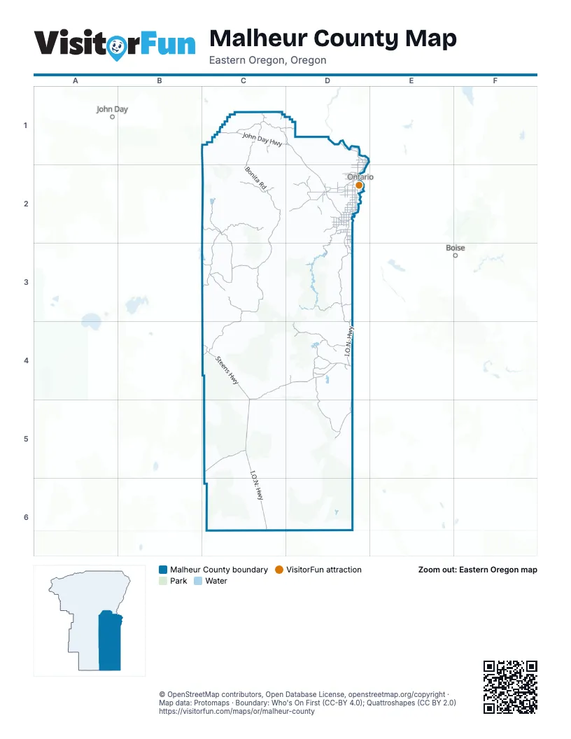
Street index of Malheur County
Each street on the sheet and the grid squares it crosses.
- Old Oregon Trail HighwayD1, D2
- Vietnam Veterans Memorial HighwayD2
- I.O.N. HighwayD3, C4, D4, C5, C6
- Central Oregon HighwayC2, D2
- John Day HighwayC1, D1, D2
- Steens HighwayC4, C5
- Olds Ferry-Ontario HighwayD1, D2
- Stanton BoulevardD2
- Southwest 4th AvenueD2
- Olds Ferry–Ontario HighwayD2
- Yturri Memorial BeltlineD2
- East Idaho AvenueD2
- North Oregon StreetD2
- Weiser SpurD1
- West Idaho AvenueD2
- Main StreetD1, D2, D4
- Payette SpurD2
- Boat Landing RoadD2
- 12th Street NorthD2
- Bassett StreetD4
- East Main StreetD2
- Southwest 2nd StreetD2
- Washington Street WestD2
- 4th StreetC2, D2
- A Street WestD2
- A Street EastD2
- Washington Street EastD2
- Southwest 9th StreetD2
- Glenn Street NorthD2
- Veterans Memorial HighwayC6
- Succor Creek HighwayD2, D3
- Lytle BoulevardD2
- Clark BoulevardD2
- Owyhee AvenueD2
- Jefferson DriveD2
- Enterprise AvenueD2
- Big Bend RoadD2, D3
- State Line RoadD2, D3
- Primrose RoadD2
- Roswell RoadD2
- Folly Farm RoadC4
- Homedale Spur HighwayD3
- Russett RoadD2
- Janeta AvenueD2
- North Verde DriveD2
- Adrian BoulevardD2
- Huntington HighwayD1
- Washington AvenueD2
- Adrian-Caldwell HighwayD2
- 1st StreetC2, D2
- Fields-Folly Farm RoadC4
- Glenn Street SouthD2
- South Verde DriveD2
- Highway 18D2
- Red Top RoadD2
- Crowley RoadC2, C3
- Crowley-Riverside RoadC3, C4
- Succor Creek RoadD3, D4
- Willow Creek RoadC1, D1
- Bonita RoadC1, C2
- Juntura-Riverside RoadC2, C3
- Three Forks RoadD4, D5
- Bully Creek RoadC2, D2
- Owyhee Lake RoadD2, D3
- Granite Creek RoadC3
- Whitehorse Ranch RoadC5
- Beulah RoadC2
- Blowout Reservoir RoadD4
- Juniper Mountain RoadC1, D4, D5
- Danner RoadD4
- Shumway RoadC2, C3
- Leslie Gulch RoadD3
- Fenwick Ranch RoadD5
- Foothill DriveD2
- Shumway Cutoff RoadC3
- Harper-Westfall RoadC2
- Lower Cow Creek RoadD4
- Graham BoulevardD2
- Cow Hollow RoadD2
- Mitchell Butte RoadD2
- Reservoir RoadD2, C3
- Railroad AvenueD2
- Alameda DriveD2
- Napton RoadD3
- Jordan Lodge RoadD4
- Huntington RoadC1, D1
- Hyline RoadD1, D2
- Anawalt RoadD4
- Overstreet RoadD2
- Morgan AvenueD2
- Birch Creek RoadD4
- Klamath AvenueD2
- Jacobsen Gulch RoadD2
- Mendiola RoadD2
- Indian Gulch RoadC1
- Mormon Basin RoadC1
- Grove RoadD1
- Lodge Ranch RoadD4
- Columbia AvenueD2
- Pioneer RoadD1, D2
- Danner Loop RoadD4
- Grand AvenueD2
- Airport RoadC2, D2
- McBride RoadD3
- Echo RoadD2
- Evergreen RoadD2
- Lincoln DriveD2
- Heritage DriveD2
- King AvenueD2
- Grey BoulevardD2
- Holly RoadD1
- Cow Creek RoadD4
- Butte DriveD2
- Juniper RoadD1
- Gem AvenueD2
- Twilight DriveD2
- Halliday RoadD2
- Canyon Two RoadD2
- Cloverdale AvenueD2
- Annex RoadD1
- Arock RoadD4
- Eureka AvenueD2
- Alberta AvenueD2
- Southwest 18th AvenueD2
- Ontario Heights RoadD2
- Cordero RoadC6
- Rye Valley RoadC1
- Southeast 2nd StreetD2
- Vale View RoadD2
- Norwood DriveD2
- Fairview DriveD2
- Pheasant RoadD2
- Dinwitty LaneD4
- Sugar AvenueD2
- Shasta CutoffC1
- Community RoadD2
- Sage RoadD2
- Malheur Reservoir RoadD1
- Lansing RoadD1
- Imperial AvenueD2
- Arcadia BoulevardD2
- Ivanhoe AvenueD2
- Kimberly RoadD2
- Yturri BoulevardD4
- Oak RoadD2
- Southwest 4th StreetD2
- Kochsmeier RoadD2
- Park AvenueD2
- Viewcrest DriveD2
- Lagoon DriveD2
- Highland DriveD2
- Golden Age Mine RoadC1
- Southeast 5th AvenueD2
- Willow RoadD2
- Northwest 36th StreetD2
- North 3rd StreetD2
- Chimney Creek RoadC2
- Southeast 18th AvenueD2
- Locust AvenueD2
- Locust RoadD2
- Kurtz RoadD2
- Vine RoadD1
- Southwest 5th AvenueD2
- Park BoulevardD2
- Chester RoadD2
- Silver City RoadD4
- Silver City CutoffD4
- Norwood AvenueD2
- Southeast East LaneD2
- Bellows DriveD2
- Elm Street NorthD2
- South Oregon StreetD2
- Thrifty WayD2
- Harper RoadC2
- Southeast 13th StreetD2
- Hildah RoadC2
- Vale West HighwayD2
- 10th Street NorthD2
- South Dorian WayD2
- Northeast East LaneD2
- Southwest 36th StreetD2
- Drake StreetC2
- Malheur Line RoadD1
- Southeast 1st CourtD2
- Clarks Creek RoadC1
- Edith StreetC2
- Goodfellow LaneD2
- Nevada StreetD4
- East LaneD2
- Trout Creek RoadD4
- Skull Creek RoadC4, D4, D5
- Peacock Lake RoadD5, C6, D6
- Rose Creek RoadC1
- Beber Ranch RoadC5
- Mahogany Gap RoadD3, D4
- Lockett RoadD1
- Jackson Creek RoadC6
- Disaster Peak RoadC6
- Twin Springs RoadD2, D3
- Oregon AvenueD4
- Old Oregon TrailD1, D2
- Bowden Ranch RoadC5
- Ackerman RoadD4
- Star Ranch RoadC3
- Tent Creek RoadD6
- Gulch Place RoadD4
- Oregon Canyon RoadC6
- Alkali Gulch RoadD2
- Whiskey Creek RoadC3
- Hill RoadD1
- Haystack Rock RoadD2, D3
- Little Valley RoadC2, D2
- Upper Horse Camp Reservoir RoadD5
- Moores Hollow RoadD1
- Greenfield RoadD2
- Sand Hollow RoadD2
- Beal Ranch RoadC2
- Greeley Ranch RoadD3
- Agency Mountain RoadC2
- Indian Fort Creek RoadC4, C5
- Loop RoadD2
- Archie Myers Ranch RoadC6
- Old Stage RoadC2
- Cleto RoadC6
- Onion AvenueD2
- Military RoadC1
- Kiger RoadC4
- Swamp Creek RoadC3
- Kimball RoadD1, D2
- Bishop RoadD2
- Power RoadD1, D2
- Allison RoadD3
- Wroten RoadD4
- Mustang Reservoir RoadD5
- Bennett DriveD4
- Alder RoadD2
- Mesquite RoadD1
- Hope RoadD2
- Pole Creek RoadD1, C6, D6
- Zimmerman Ranch RoadC6
- Buckhorn RoadD1
- Cottonwood RoadC2, C3
- Shumway Ranch RoadC3
- Douglas RoadD2
- Hillcrest DriveD2
- Bench RoadD2
- Copeland RoadC2
- Mc Ewen RoadC3
- Cherokee Creek RoadC6
- Mormon Basin Cutoff RoadC1
- Downey CanyonD4
- Sheep Spring RoadD4
- Alkali Flats RoadD2
- Rock Spring Canyon RoadD2
- Fells Spring RoadD4
- Stage RoadD2
- West Cedar RoadD2
- Miller RoadD2, D3
- Shell Rock RoadD2
- Rattlesnake Creek RoadC5
- Heinz BoulevardD2
- Jordan Creek RoadD4
- Jack Creek RoadD4
- Beaumont RoadD2
- Grove School LaneD2
- Iron Mountain RoadC4
- 7th Avenue WestD2
- Cassia RoadD2
- Wilkinson RoadC6
- Northwest 4th AvenueD2
- Ridgeview RoadD3
- Maag Road NorthD1
- Antelope Flat RoadC3
- Desert Glen RoadD3
- Russell RoadD2
- 6th Avenue WestD2
- South Road GD2
- Fulleton RoadD2
- McCoy RoadC1
- Schweizer RoadD2
- Chestnut AvenueD2
- Wet WayD2
- Syringa RoadD2, D3
- West Elm RoadD2
- Ivy RoadD1
- Lonesome RoadD3
- Bogus Ranch RoadC4, D4
- Antelope Reservoir RoadD4
- Gilbert Ranch RoadC5
- 9th Avenue WestD2
- East Island RoadD2
- Echave Ranch RoadC6
- Rhinehart Butte LaneD2
- Dahle RoadC2
- Swisher LaneD4
- River View DriveD2
- Butler BoulevardD2
- Court RoadD1, D2
- Malheur DriveD2
- Fells Spring CutoffD4
Things to do on the Malheur County map
Places on the map
- Adrian
- Alvord Desert Wilderness Study Area
- Anderson Reservoir
- Antelope Reservoir
- Arock Diversion Reservoir
- Beaver Dam Creek Wilderness Study Area
- Beulah Reservoir
- Blue Canyon Wilderness Study Area
- Bowden Hills Wilderness Study Area
- Brewster Reservoir
- Bully Creek Reservoir
- Camp Creek Wilderness Study Area
- Castle Rock Wilderness Study Area
- Cedar Mountain Wilderness Study Area
- Chevally Reservoir
- Clarks Butte Wilderness Study Area
- Cottonwood Creek Wilderness Study Area
- Coyote Lake
- Dry Creek Buttes Wilderness Study Area
- Dry Creek Wilderness Study Area
- Fifteenmile Creek Wilderness Study Area
- G A Parker Reservoir
- Gartin Reservoir
- Gold Creek Wilderness Study Area
- Hanna Reservoir
- Honeycombs Wilderness Study Area
- Jordan Craters
- Jordan Craters Wilderness Study Area
- Jordan Valley
- Lookout Butte Wilderness Study Area
- Lower Owyhee Canyon Wilderness Study Area
- Ontario Municipal Airport
- Oregon Canyon Wilderness Study Area
- Owyhee River Canyon Wilderness Study Area
- Palomino Hills Wilderness Study Area
- Saddle Butte Wilderness Study Area
- Sheepshead Wilderness Study Area
- Twelvemile Creek Wilderness Study Area
- Upper West Little Owyhee Wilderness Study Area
- Wildcat Canyon Wilderness Study Area
Next to Malheur County
- Boise
- John Day
© OpenStreetMap contributors, Open Database License, openstreetmap.org/copyright · Map data: Protomaps · Boundary: Who's On First (CC-BY 4.0); Quattroshapes (CC BY 2.0)















