

Oregon map
Roseburg map
About 23,795 people live here (Census Bureau, 2024 estimate). The sheet's index lists 300 streets; Northeast Stephens Street, Northwest Garden Valley Boulevard and Military Avenue cross the most grid squares. Things to do inside the boundary: Umpqua Valley Wine Trail.
Open the map (PDF, US Letter)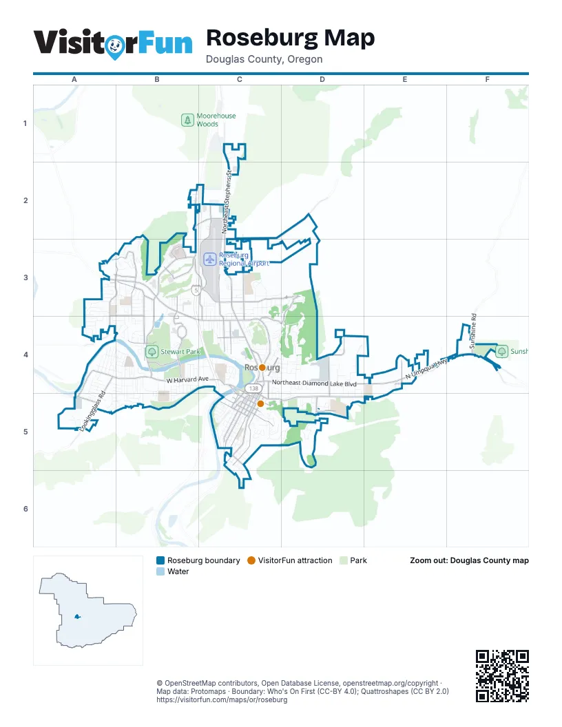
Street index of Roseburg
Each street on the sheet and the grid squares it crosses.
- Interstate Highway 5C4
- Northeast Stephens StreetC1, C2, C3, C4
- North Umpqua HighwayE4, F4
- West Harvard AvenueA4, B4, C4
- Northwest Garden Valley BoulevardA3, B3, B4, C4
- Northeast Diamond Lake BoulevardC4, D4, E4
- Southeast Stephens StreetC5
- Southeast Pine StreetC4, C5
- Southeast Washington AvenueC4, C5
- Northeast Garden Valley BoulevardC4
- Southeast Oak AvenueC4, C5
- Southwest Oak AvenueC4
- Northwest Stewart ParkwayB3, C3, B4
- Southeast Douglas AvenueC4, C5, D5
- Southeast Main StreetC4, C5
- Northwest Edenbower BoulevardB2, C2, B3
- Southeast Jackson StreetC4, C5
- Lookingglass RoadA4, A5
- Northeast Jackson StreetC4
- Northeast Winchester StreetC4
- Northwest Mulholland DriveC3, C4
- Northeast Stewart ParkwayC3
- Garden Valley BoulevardA3
- Stewart ParkwayB4
- Northeast Newton Creek RoadC2, D2
- Northwest Kline StreetA3, B3
- Northwest Veterans WayB3, B4
- Northeast Alameda AvenueC3, D3
- Northwest Troost StreetA3, B3, A4
- Southeast Kane StreetC5
- Northeast Rifle Range StreetD4, D5
- Northeast Vine StreetC2, C3, C4
- Northwest Keasey StreetB3, B4
- Northeast Rocky Ridge DriveD3, C4, D4
- Northwest Stewart Park DriveB4
- Southeast Lane AvenueC5
- Northeast Lincoln StreetC4
- Aviation DriveC3
- Northwest Valley View DriveA3, B3
- Northeast Airport RoadC3, C4
- Northeast Douglas AvenueD5, E5
- Northwest Aviation DriveC2, C3
- Old Melrose RoadA4, A5
- Northwest Calkins AvenueA3, B3
- Northeast Walnut StreetC4
- Southeast Mosher AvenueC5
- Mercy DriveB3
- Northeast Cedar StreetC4
- Northwest Harvey AvenueB4
- Southeast Rose StreetC4, C5
- Southeast Ramp RoadD5
- Northeast Chestnut AvenueC4
- Southeast Booth AvenueC5, C6
- Southeast Cass AvenueC5
- Pomona StreetE4
- Northwest Hughwood AvenueA3, B3
- West Goedeck AvenueA5
- Southeast Spruce StreetC4, C5
- Northwest Broad StreetB2
- Southeast Waldon AvenueD5
- Northwest Estelle StreetB3
- Kincaid DriveE4
- Renann StreetB3
- Sunshine RoadF4
- Southeast Parrott StreetC5
- General AvenueB2, C2
- Southeast Fowler StreetC4, C5
- Southeast Sheridan StreetC5
- Douglas AvenueE4
- Buckhorn RoadF4
- Northeast Wright AvenueC4
- Northeast Fowler StreetC4
- Keller RoadC1
- Military AvenueB4, C4, A5, B5
- Northeast Fulton StreetD4
- Northwest Hicks StreetC4
- Southeast Terrace DriveC5, D5
- Northeast Brooklyn AvenueC3, D3
- West Lorraine AvenueA4, A5, B5
- Southeast Mill StreetC5
- Northeast Commercial AvenueC4, D4
- West Broccoli StreetB4, B5
- Northeast Klamath AvenueC4, D4
- West Hickory StreetA4
- Loma Vista DriveA4
- Northwest Lincoln DriveB4
- Northeast Rocky DriveD3, D4
- Northwest Van Pelt DriveB3
- Southeast Cobb StreetC5
- Northeast Todd StreetC3
- West Luellen DriveB4, B5
- Northeast Freemont AvenueC4, D4
- West Hazel StreetA4
- Northeast Beulah AvenueC4
- Northeast Grandview DriveC4
- Northeast Bellview CourtC4
- Southeast Eddy StreetC5
- West Ballf StreetB4
- Southeast Hamilton StreetC5
- Southeast Summit DriveC5, D5
- Southeast Flint StreetC5
- West Sherwood AvenueA4, B4
- West Berdine StreetA4
- Northwest Cherry DriveA3, A4, B4
- Clover AvenueC3
- West Oriole DriveA4, B4
- West Brown AvenueB4
- West Pilger StreetB4, B5
- Northeast Barager AvenueC3
- Northwest Daysha DriveB2, B3
- Northeast Nash StreetC4
- West Umpqua StreetC4
- Northeast Casper StreetD4
- Northeast Roseland AvenueC3
- West Bradford AvenueA4, B4
- Northwest Jefferson StreetB3, B4
- Northwest Highland StreetC4
- West Harrison StreetB4
- Northeast Malheur AvenueC4, D4
- Northeast Sunset StreetC3
- Northeast Channon AvenueC3
- Northeast Oakland AvenueC3
- Quarry RoadE4, F4
- Southeast Chadwick StreetC5
- West Jay AvenueA4, B4
- Northeast Ventura StreetD4
- Northeast Boston StreetC4
- Northwest Excello DriveA3
- Northwest Canterbury DriveA3
- Northeast Meadow AvenueC3
- Northeast Willow StreetC3, C4
- Southeast Rice AvenueC5
- Southeast Hawthorne DriveC5
- Northwest Witherspoon AvenueA3
- Southeast Fullerton StreetC5
- West Sharp AvenueA4, B4
- Northwest Domenico DriveB4
- Northeast Granite Ridge StreetD4
- Northwest Hill AvenueB3
- Northwest Lynwood StreetB3
- Northeast Mary Ann LaneC1
- Northwest Avery StreetA3, A4
- Northwest Dogwood DriveB3
- Northeast Cummins StreetD4
- West Kenwood StreetB4, B5
- West Stanton StreetB4, B5
- Northwest Eden StreetC3, C4
- West Riverside DriveC4
- West Myrtle AvenueB4, B5
- West Center StreetA4
- Northeast Spyglass LoopC4
- Medical LoopB3
- Northeast Odell AvenueC4, D4
- Southeast Parkwood DriveC5, D5
- Northwest Fairmount AvenueC3, C4
- Southeast Hoover AvenueC5
- Southeast Pitzer StreetC4, C5
- Southeast Laurel CourtC5
- Northeast West AvenueC4
- Northwest Centennial DriveB4
- Southeast Starmer StreetC5
- West Madrone StreetC4
- Moorea DriveB3
- Southeast Marsters AvenueC5, C6
- West River Ridge AvenueA4, A5
- Northwest Cecil AvenueB3, C3
- Northwest Moore AvenueB3
- West Fairhaven StreetB4, B5
- Kenneth Ford DriveC1
- Southeast Giles StreetC5
- West Rosemary AvenueA5
- Harris Hills DriveA5
- Linus LaneB3
- Southeast Overlook AvenueC5
- Southeast Sharon AvenueD5
- Northeast Hollis StreetC3, C4
- Southeast Magnolia StreetC5
- West Francis StreetB4
- Northeast Kennedy Loop DriveD3
- Northeast Winter StreetC3
- Southeast Chinaberry AvenueD5
- Southeast Lois LaneD5
- Northeast Danita LaneC1
- West Nebo StreetB4, B5
- Southeast Roberts AvenueC5
- Northwest Vallejo DriveA4
- West Indianola StreetB4, B5
- Northeast Emerald DriveC3
- West Shasta AvenueA4
- Northwest Delridge AvenueA3, B3
- Southeast Court AvenueC4
- West Rainbow StreetB4, B5
- Southeast Strong AvenueC5, C6
- Northeast Beulah DriveC4
- Northwest Beaumont StreetB3
- West Chateau AvenueA4
- Kirby AvenueC3, D3
- Northeast Housley AvenueC2
- Savanna LaneA3
- Southeast Leland StreetD5
- Northeast Jerry's DriveC1
- West Maple StreetB4
- Northeast Reagan DriveD3
- Northwest Chambers DriveA4
- Northwest Munson CourtC4
- West Elizabeth StreetB4
- West River Ridge LaneA5
- West Wharton StreetB4
- Southeast Sanford AvenueC5
- Northeast Crescent StreetC4
- Northwest Glenmar AvenueA4
- West Normandy AvenueA4, A5
- Northwest Sunberry DriveA3
- Northeast Garrecht StreetD4, D5
- West Union StreetB4, B5
- Northeast Lombardy DriveD4, D5
- Northeast Sunset Loop DriveC3
- Northwest Beacon StreetC3, C4
- Duck Pond RoadB3, B4
- Northeast Patterson StreetD4, D5
- Northwest Esquire DriveA3
- Northwest Watters StreetB3
- West Finlay AvenueC4
- Northwest Whipple StreetB4
- Northeast Central StreetC4
- Northwest Evans AvenueB3
- Northwest Woodstock DriveB2, B3
- West Haggerty StreetB4
- Northwest Luth StreetB3
- Southeast Hillside AvenueD5
- West Fromdahl DriveB5
- Northwest Kring StreetB4
- West Crestview AvenueB5
- West Princeton AvenueC4
- Northeast Post StreetC4
- ChadwickC5
- Northwest Oerding AvenueA4, B4
- West Shenandoah StreetB4
- Northeast Morris StreetC3
- West Fair StreetB4
- Northeast Denver StreetD4
- Northwest Sweetbrier AvenueB2, C2
- Southeast Reservoir AvenueC5
- West Agee StreetB4
- Northwest Calkins CourtA3, A4
- Northwest Utah DriveB3
- West Winter Ridge DriveB5
- Northeast Oswego AvenueD4
- Northeast Sterling DriveC3
- Northwest Grove LaneA3, A4
- Northwest Lemans StreetB3
- Northwest Stacie CourtA3
- Northwest Woodwillow DriveB3
- Northeast Neuner StreetC4
- Northeast Northpark LaneC3
- Northeast Miguel AvenueD4
- Southeast Waite AvenueC5
- Southeast Sykes AvenueC5
- West Tarragon DriveA5
- Southern Golden Eagle StreetD5
- Northwest Andrea StreetA3
- Northwest Goetz StreetB3
- Junker AvenueC4
- Spring AvenueC5
- Northwest Ellan StreetC4
- Southwest Bellows StreetC4
- Northwest Black AvenueB3
- Northeast Ward AvenueC4
- Southeast Miller AvenueC5
- Northeast Shale CourtD4
- Northwest Almond AvenueB3
- West Chapman StreetC4
- Northeast Flagg StreetD4, D5
- Northwest Crouch StreetB3
- West Keady CourtB4
- Turken LaneF4
- Northeast Polk StreetC4
- West Alpha StreetB4
- West Bowden StreetC4
- Northwest Riverview DriveB4
- Southeast Arizona StreetC5
- Northeast Dixon StreetC4
- Frontier LaneD4
- Southeast Ivy DriveD5
- West Bodie StreetA4
- Northeast Atlanta StreetC4
- Northeast Russell AvenueC3
- West Foothill DriveB4
- Cedar Ridge CourtA4
- Northwest Parkdale AvenueA4
- Northwest Apache DriveB3
- Southeast Houck AvenueC5
- Southeast Thompson StreetC5
- Southeast Burke StreetC5
- Southeast Fisher DriveC5
- Northwest Caribou LaneC3
- Northeast Church AvenueC3
- Southeast Floed StreetC5
- Southeast Glenn StreetC5
- Southeast Rifle Range StreetD5
Things to do on the Roseburg map
Places on the map
- Adolf Park
- Alason M. Randol, DDS
- Andrea V. Grey M.D. P.C.
- Baymont Roseburg
- Best Western Garden Villa Inn
- Betty Long Unruh Theater
- Charles Gardiner Park
- CHI Mercy Health Mercy Medical Center
- Douglas County Library
- Duck Pond Park
- Eastwood Elementary School
- Fir Grove Elementary School
- Fir Grove Park
- Fullerton IV Elementary School
- Gaddis Park
- Hucrest Elementary School
- John C Fremont Middle School
- Joseph Lane Middle School
- Joseph Lane Woods
- Laurelwood Historic District
- Micelli Park
- Mill-Pine Neighborhood Historic District
- Northwest Hicks Street
- Phoenix School
- Riverfront Park
- Riverside Park
- Rose Elementary School
- Roseburg Christian Academy
- Roseburg Downtown Historic District
- Roseburg High School
- Roseburg IOOF Cemetery
- Roseburg Marketplace
- Roseburg Regional Airport
- Roseburg VA Medical Center
- Stewart Park
- Stewart Park Golf Course
- Stewart Park Wildlife Pond
- Templin Beach Park
- The Home Depot
- Walmart Supercenter
© OpenStreetMap contributors, Open Database License, openstreetmap.org/copyright · Map data: Protomaps · Boundary: Who's On First (CC-BY 4.0); Quattroshapes (CC BY 2.0)















