

Oregon map
Douglas County map
About 112,255 people live here (Census Bureau, 2024 estimate). The sheet's index lists 300 streets; North Umpqua Highway, Frontage Road and Forest Road 29 cross the most grid squares. Things to do inside the boundary: Abacela Vineyards & Winery, Bar Run Golf & RV Resort and Oregon Dunes National Recreation Area.
Open the map (PDF, US Letter)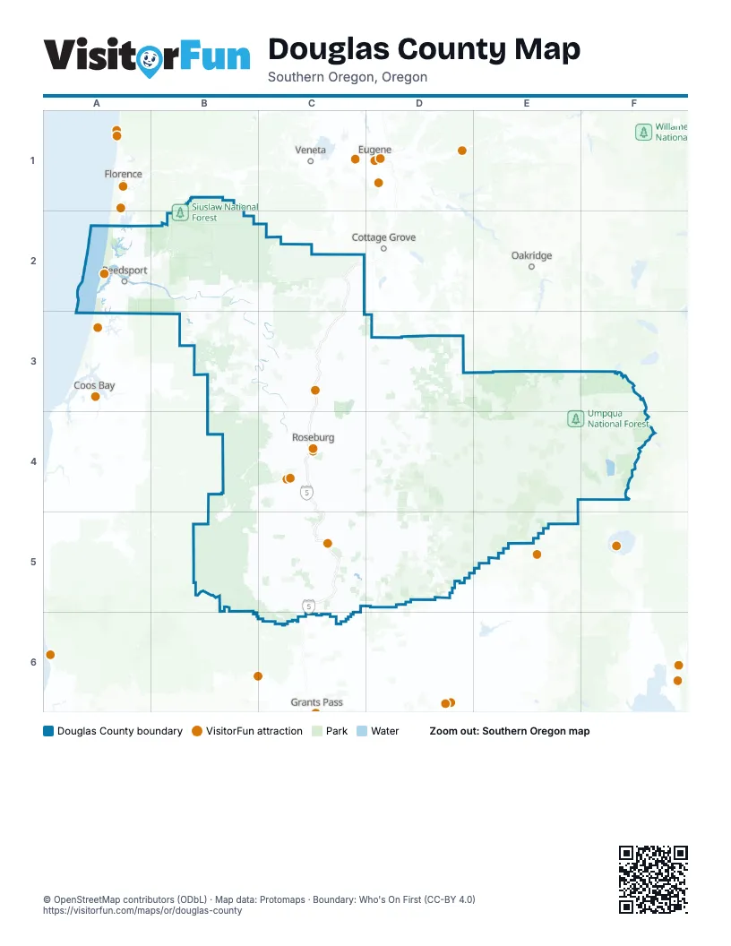
Street index of Douglas County
Each street on the sheet and the grid squares it crosses.
- Highway #001XX - Riddle Road Connection #6C5
- Interstate Highway 5C4
- Highway #001FS - Riddle Road Connection #1C5
- Highway #001FT - Riddle Road Connection #2C5
- Highway #001FW - Riddle Road Connection #5C5
- Highway #001FV - Riddle Road Connection #4C5
- North Umpqua HighwayD3, E3, C4, D4, E4, F4
- Umpqua HighwayA2, B2, C2
- Coos Bay-Roseburg HighwayB4, C4, B5
- State Highway 138 WestB2, B3, C3
- Oregon Coast HighwayA2, A3
- Diamond Lake HighwayE4, F4, E5
- Dillard HighwayC4
- Bear Creek RoadC2, B3
- Northeast Stephens StreetC4
- Territorial HighwayC2
- Weaver RoadC5
- Old Highway 99 SouthC4
- State Highway 38B2, C2
- Curtin RoadC2
- North Old Pacific HighwayC5
- Winchester AvenueA2
- Brockway RoadC4
- North Main StreetC2, C4, C5
- West Harvard AvenueC4
- South Main StreetC2, C4, C5
- South Calapooia StreetC3
- East Diamond Lake HighwayF4
- Northwest Garden Valley BoulevardC4
- Northeast Diamond Lake BoulevardC4
- West Central AvenueC3
- Southeast Stephens StreetC4
- Fir AvenueA2, C3
- Southeast Pine StreetC4
- Park Hill LaneC3
- Southeast Washington AvenueC4
- Northeast Garden Valley BoulevardC4
- Douglas BoulevardC4
- Southeast Oak AvenueC4
- Umpqua AvenueA2
- Myrtle HighwayC5
- Northbank RoadC3
- Myrtle Creek Connection #3C5
- Myrtle AvenueA2
- North First StreetC2
- Southwest Oak AvenueC4
- West B AvenueC2
- Weaver Road Connection #2C5
- Tiller Trail HighwayC5, D5
- North Bank RoadC4, D4
- Nonpareil RoadC3, D3
- Coos Bay Wagon RoadB4, C4
- Elkhead RoadC3
- Lookingglass RoadC4
- Driver Valley RoadC3
- Garden Valley RoadC3, C4
- Scotts Valley RoadC3
- Old Highway 99 NorthC3, C4
- Clarks Branch RoadC4
- Fort McKay RoadC3
- Flournoy Valley RoadC4
- Eagle Valley RoadC2, C3
- Northeast Dole RoadC4, C5
- Riddle Bypass RoadC5
- Melrose RoadC4
- Anlauf RoadC2, C3
- Canyonville-Riddle RoadC5
- Happy Valley RoadC4
- Reston RoadB4
- Del Rio RoadC4
- Stearns LaneC3
- Old Melrose RoadC4
- Northwest Stewart ParkwayC4
- Old Pioneer RoadC3
- Yokum RoadC5
- Glendale Valley RoadC5, C6
- Crater Lake Highway NorthF4
- Stanton Park RoadC5
- Pruner RoadC5
- Southeast Main StreetC4, C5
- Main StreetB2, C3, C5
- East Central AvenueC3
- Northwest Edenbower BoulevardC4
- Frontage RoadA2, C3, C4, C5
- Drain-Yoncalla HighwayC2
- Southeast Douglas AvenueC4
- South Old Pacific HighwayC5
- Southeast Jackson StreetC4
- Northeast Oak StreetC3, C5
- Southeast 3rd StreetC3, C5
- 1st AvenueC5
- Ravenswood RoadC5
- Oakland-Shady HighwayC3
- East Happy Valley RoadC4
- Northeast Jackson StreetC4
- North State StreetC3
- Northeast Winchester StreetC4
- Garden Valley BoulevardC4
- South Cedar StreetC2
- Abraham AvenueC4
- Northwest Mulholland DriveC4
- North 1st StreetC2, C3
- Southwest 5th StreetC5
- Southwest Frontage RoadC5
- West 1st StreetC5
- Gilbert StreetC6
- Creekside DriveC5
- Molly StreetC6
- South Front StreetC3
- Sether AvenueC6
- Northeast Stewart ParkwayC4
- Old Winchester BridgeC4
- North Cedar StreetC2
- Stewart ParkwayC4
- Yoncalla Connection #1C3
- Adair BridgeC4
- South Umpqua RoadD4, E4, D5
- Lower Smith River RoadA2, B2
- Smith River RoadB2, C2
- Forest Road 29D4, E4, D5, E5
- Cow Creek RoadB5, C5, C6
- Forest Road 27D4, E4
- Tyee RoadB3, C3
- Callahan RoadB4, C4
- Little River RoadD4
- Upper Cow Creek RoadC5, D5
- South Myrtle RoadC4, D4, C5, D5
- Fish Creek RoadE4
- Cavitt Creek RoadD4
- Lemolo Lake Road / Birds Point RoadF3, F4
- Huckleberry Gap RoadE5
- North Myrtle RoadC4, D4, C5
- Loon Lake RoadB2, B3
- Camp Creek RoadB2, B3
- Buckhorn RoadC4, D4
- Forest Road 2154E3, F3
- Rock Creek RoadC2, D3
- Forest Road 38D3, E3
- Hubbard Creek RoadB3, C3, B4
- Big Camas RoadE4
- Wtc 5000 RoadB4
- Diamond Lake LoopF4
- Bureau of Land Management Road 25 7 5B3
- Azalea-Glen RoadC5, C6
- North Fork Smith River RoadB2
- West Fork Cow Creek RoadB5
- South Sisters RoadB2, C2
- Roberts Creek RoadC4
- Melqua RoadC3, C4
- Forest Road 2153F3
- Callahan Creek RoadD5
- Green Valley RoadC3
- Bureau of Land Management Road 31D3
- Burnt Ridge RoadB4
- Henderer RoadB2
- Mehl Creek RoadB2, B3
- Bullock RoadB3, C3
- Rice Valley RoadC3
- Hayhurst RoadC2, C3
- Rice Creek RoadC4, C5
- Forest Road 32D5
- Bureau of Land Mgmt Rd 25-1E31D3
- Dutch Henry RoadB5
- Timpanogas RoadE3, F3
- Oak Hill RoadC3, C4
- Windigo Pass RoadF3, F4
- Snow Creek RoadD5
- Bureau of Land Mgmt Rd 26-9-7.B4
- Goodrich HighwayC3
- Cole RoadC3
- Boswell RoadC2
- Toketee-Rigdon RoadE4
- Upper Camas RoadB4
- Kelsey Mule RoadB5
- Willis Creek RoadC4, C5
- Days Creek RoadC5, D5
- Upper Olalla RoadC4, B5, C5
- Rock Creek Access RoadD3
- Kelsay Calamut Loop RoadF3, F4
- Strickland Canyon RoadC4
- Gazley RoadC5
- Sunshine RoadC4
- South Smith River RoadA2
- Elgarose RoadC4
- Hogan RoadC3
- Reuben RoadC5, C6
- Bureau of Land Mgmt Rd 13-0D3
- Olalla RoadC4
- Colonial RoadC4
- Walker Prairie RoadB5
- Glenbrook Loop RoadC5
- United States Forest Service Road 48B1, B2
- Boomer Hill RoadC4, C5
- Quines Creek RoadC5, C6
- Forest Road 2612F4
- Shoestring RoadC3, C5
- Page RoadC4
- Salmon Harbor DriveA2
- Cleveland Hill RoadC4
- Whistlers Park RoadC4
- Fisher RoadC4
- Wild River DriveC4, D4
- Doerner RoadC4
- Northeast Newton Creek RoadC4
- National Forest Development Road 060F4
- Lighthouse RoadA2, C3
- Dixonville RoadC4
- Wtc 8000 RoadB3, B4
- Westside RoadB4, B5
- Tenmile Valley RoadB4, C4
- Metz Hill RoadC3
- Ranchero RoadC5
- Wells RoadB3
- Azalea DriveB2, C2, B3, C3
- Toketee Ranger Station RoadE4
- Dairy Loop RoadC4
- Warm Springs Butte RoadF3
- South Elk Creek RoadC2
- Northside RoadC3
- Bureau of Land Management Road 5 4D3
- Curry RoadC4
- John Long RoadC3
- Orchard LaneC4
- Sawyer Creek RoadB2, B3
- Ireland RoadB4, C4
- Northwest Troost StreetC4
- Glengary Loop RoadC4
- Bohemia RoadD3
- San Souci DriveC4
- Chadwick LaneC5
- Plat K RoadC3
- Southside RoadC3
- Old Garden Valley RoadC4
- Plat I RoadC3
- Cooper Creek RoadC3
- Wilbur RoadC4
- Ben Irving RoadB4
- Bureau of Land Management Road 23 3 5D3
- Whistlers LaneC4
- National Forest Development Road 2614F4
- Hoover Hill RoadC4
- Cedar Creek RoadB3, B4
- Aviation DriveC4, C5
- Scottsburg Road WestB2
- Berry Creek RoadB4
- Glide Loop DriveD4
- Winston Section RoadC4
- Iverson RoadC3
- Carnes RoadC4
- Wildwood DriveA2, A3
- Safari RoadC4
- Taylor StreetC3, C5
- Oxbow Creek RoadC2
- Churchill DriveC3
- Quail LaneC4
- Main Camas RoadB4, B5
- Bureau of Land Mgmt Rd 1.0D3
- Northeast Division StreetC5
- Arcadia DriveC4
- West 6th AvenueC3, C5
- South Comstock RoadC3
- Northwest Kline StreetC4
- Barton RoadC5
- Rogers RoadC3
- Valley View RoadC3
- Fair Oaks RoadC3
- Speedway RoadC4
- Rolling Hills RoadC4
- Cascade Lakes HighwayF4
- Northwest Veterans WayC4
- Wilcox RoadC3
- Douglas AvenueC4
- Northeast Rifle Range StreetC4
- Austin RoadC4
- Benedict RoadB4
- Northeast Alameda AvenueC4
- London Hill RoadC3
- Umpqua College RoadC4
- Grant Smith RoadC4
- East Riverside DriveC5
- Southeast Kane StreetC4
- Longwood DriveA2
- North Comstock RoadC3
- Rochester Bridge RoadC3
- Gross LaneC3
- Booth Ranch RoadC4
- Isadore RoadC3
- Locust StreetC3
- Rolling Ridge RoadC3
- Little Valley RoadC4
- Northeast Vine StreetC4
- Northeast Douglas AvenueC4, C5
- Hooker RoadC4
- Grange RoadC4
- Ingram DriveC4
- Northwest Keasey StreetC4
- Northeast Rocky Ridge DriveC4
- Drain Section RoadC2
- Oakview DriveC4
- 5th AvenueC5
Things to do on the Douglas County map
Places on the map
- Alkali Meadows
- Ben Irving Reservoir
- Big Camas Meadow
- Big Swamp
- Boulder Creek Wilderness
- Britt Nichols Park
- Broken Arrow Campground
- Bulldog Prairie
- Callahan Meadows
- Canyonville
- Carter Lake
- Chief Miwaleta Park
- Clear Lake
- Compton Quarry
- Cooper Creek Reservoir
- Cougar Canyon Golf Course
- Diamond Lake
- Diamond Lake Campground
- Douglas County Fairgrounds
- Douglas County Landfill
- Drain
- Eel Lake
- Elkton
- Elkton Oregon AVA
- Fish Lake
- Ford's Pond
- Forest Hills Country Club
- Formosa Mine Superfund Site
- Galesville Reservoir
- Glendale
- Green
- Helios Farms
- Hummingbird Meadows
- Kinnan Reservoir
- Lemolo Forebay No. 2
- North Bank Habitat Management Area
- Rogue-Umpqua Divide Wilderness
- Roseburg Regional Airport
- Siuslaw National Forest
- Umpqua National Forest
Next to Douglas County
- Coos Bay
- Cottage Grove
- Eugene map
- Florence
- Oakridge
- Springfield
- Veneta
© OpenStreetMap contributors, Open Database License, openstreetmap.org/copyright · Map data: Protomaps · Boundary: Who's On First (CC-BY 4.0); Quattroshapes (CC BY 2.0)