

Oregon map
Salem map
About 180,406 people live here (Census Bureau, 2024 estimate). The sheet's index lists 300 streets; Commercial Street Southeast, Kuebler Boulevard Southeast and Turner Road Southeast cross the most grid squares. Things to do inside the boundary: Englewood Forest Festival, Oregon State Capitol and Southern Oregon Coast.
Open the map (PDF, US Letter)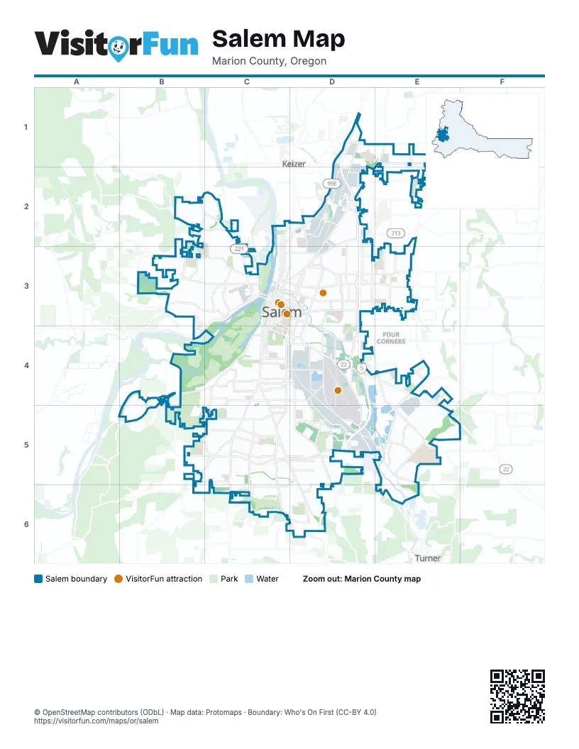
Street index of Salem
Each street on the sheet and the grid squares it crosses.
- Doctor Martin Luther King Junior ParkwayD1, C2, D2
- North Santiam HighwayD4, E4, E5
- Commercial Street SoutheastC3, C4, C5, D5, D6
- Kuebler Boulevard SoutheastE4, C5, D5, E5
- Wallace Road NorthwestB2, C2, C3
- Turner Road SoutheastD4, D5, E5, E6
- River Road SouthB4, C4, B5
- Center Street NortheastC3, D3, E3
- Mission Street SoutheastC4, D4
- Portland Road NortheastE1, D2, D3
- Liberty Road SouthC4, C5, C6
- Salem Dallas Highway NorthwestC3, B4, C4
- 12th Street SoutheastD3, C4, D4, C5
- Market Street NortheastC3, D3, E3
- Front Street NortheastC2, C3
- Lancaster Drive NortheastD2, D3
- Commercial Street NortheastC2, C3
- Liberty Street NortheastC2, C3
- 13th Street SoutheastD3, C4, D4, D5
- Broadway Street NortheastD2, C3, D3
- Silverton Road NortheastD2, D3
- Deer Park Drive SoutheastE5
- Gaffin Road SoutheastE4, E5
- Lancaster Drive SoutheastE4, E5
- Vista Avenue SoutheastC4, D4
- Fairgrounds Road NortheastC3, D3
- Capitol Street NortheastD3
- Liberty Street SoutheastC3, C4
- Ferry Street SoutheastC3, D3, D4
- Cordon Road SoutheastE4
- Bellevue Street SoutheastC3, C4, D4
- Trade Street SoutheastC3, D3, D4
- Chemawa Road NortheastD1, E1
- Summer Street NortheastC3, D3
- Union Street NortheastC3, D3
- Marion Street NortheastC3, D3
- 12th Street NortheastD3
- Center Street BridgeC3
- Hazelgreen Road NortheastE1
- Marion Street BridgeC3
- Pringle Parkway SoutheastC3
- River Road NorthC2, D2
- Owens Street SouthC4
- Front Street SoutheastC3
- Owens Street SoutheastC4
- Hawthorne Avenue NortheastD2, D3, D4
- State StreetC3, D3, D4
- Doaks Ferry Road NorthwestB2, C2, B3
- Sunnyview Road NortheastD3, E3
- Sunnyside Road SoutheastC5, C6, D6
- Orchard Heights Road NorthwestB3, C3
- Glen Creek Road NorthwestB3, C3
- Madrona Avenue SoutheastC4, D4
- High Street SoutheastC3, C4
- 25th Street SoutheastD4
- Battle Creek Road SoutheastD5, D6
- 17th Street NortheastD3
- Church Street NortheastD2, C3, D3
- Fairview Industrial Drive SoutheastD4, D5
- Pringle Road SoutheastD4, D5
- Eola Drive NorthwestB3, C3
- Aumsville Highway SoutheastE5
- Skyline Road SouthB5, C5, B6
- Croisan Creek Road SouthC4, B5, C5
- Church Street SoutheastC3, C4
- Court Street NortheastC3, D3
- Madrona Avenue SouthC4
- Edgewater Street NorthwestC3
- Cherry Avenue NortheastD2, D3
- Pine Street NortheastC3, D3
- Hyacinth Street NortheastD2
- Fairview Avenue SoutheastC4, D4
- Bluff Avenue SoutheastC4, C5
- Kuebler Road SouthB5, C5
- Hawthorne Avenue SoutheastD4
- 17th Street SoutheastD3, D4
- High Street NortheastC3
- 12th Street Cutoff SoutheastC5
- MacLeay Road SoutheastE4
- Airport Road SoutheastD4
- Swegle Road NortheastE3
- Rickey Street SoutheastD4, E4
- 36th Avenue SoutheastD5
- 13th Street NortheastD3
- Kuebler Boulevard SouthC5
- Trelstad Avenue SoutheastD5
- Hilfiker Lane SoutheastC5
- Ward Drive NortheastD2, E2
- 32nd Avenue SoutheastD5
- Verda Lane NortheastD2
- Boone Road SoutheastC5, D5, E5
- Lone Oak Road SoutheastC5, C6
- D Street NortheastC3, D3, E3
- Park Avenue NortheastD2, D3, D4
- Fisher Road NortheastD2, D3
- Mildred Lane SoutheastC5, D5, C6
- Brush College Road NorthwestB2, C2
- 22nd Street SoutheastD4
- Croisan Scenic Way SouthC4, C5
- Chemeketa Street NortheastC3, D3
- McGilchrist Street SoutheastC4, D4
- Evergreen Avenue NortheastD2, D3
- Crestview Drive SouthC4, C5
- Strong Road SoutheastD5
- 23rd Street NortheastD3, D4
- Madison Street NortheastD3
- Norway Street NortheastC3, D3
- Baxter Road SoutheastC5, D5
- Kale Street NortheastE1
- Cottage Street NortheastC3, D3
- Marietta Street SoutheastC5, D5
- 24th Street NortheastD3, D4
- Winter Street NortheastC3, D3
- Winter Street SoutheastC3, C4
- Lansing Avenue NortheastD2, D3
- 14th Street SoutheastD3, D4
- Airway Drive SoutheastD4, D5
- Idylwood Drive SoutheastC5
- Reed Lane SoutheastD5, D6
- Salem Industrial Drive NortheastD2
- Hoyt Street SoutheastC4, D4
- Rural Avenue SoutheastC4, D4
- Mildred Lane SouthB6, C6
- Barnes Avenue SoutheastC5, D5
- Indian School Road NortheastD1, D2
- Browning Avenue SouthC5
- Homestead Road SouthB4, B5
- Hansen Avenue SouthC4
- Jones Road SoutheastC5
- Oak Street SoutheastC3, C4, D4
- Fabry Road SoutheastC5, D5
- 14th Street NortheastD3
- Ridge Drive NortheastD1, D2
- Wiltsey Road SoutheastC6, D6
- Cascade Drive NorthwestC3
- Bill Frey Drive NortheastD2
- 45th Avenue NortheastE3
- Hollywood Drive NortheastE2, E3
- Kingwood Drive NorthwestC3
- Davis Road SouthB5, C5
- Lindburg Road SoutheastD4, D5
- Hood Street NortheastC3, D3
- Claxter Road NortheastD2
- Browning Avenue SoutheastC5
- 49th Avenue NortheastE1, E2
- Stoneway Drive NorthwestB3, B4
- Mill Creek Drive SoutheastE5
- Parkway Drive NorthwestC3
- Rees Hill Road SoutheastC6, D6
- Reed Road SoutheastD5
- Michigan City Lane NorthwestB2, C2
- Cunningham Lane SouthC5
- College Drive NorthwestB3, B4
- Gath Road SoutheastE5
- Logistics Street SoutheastE5
- Mainline Drive NortheastD2
- 27th Avenue SoutheastD5
- Hrubetz Road SoutheastC5
- Ratcliff Drive SoutheastC4
- Howard Street SoutheastC4, D4
- Cottage Street SoutheastC3, C4
- Ellis Avenue NortheastD3
- Truax Drive SoutheastE5
- Salem Heights Avenue SouthC4
- Titan Drive NorthwestB3
- Christina Street NorthwestB2
- Fairway Avenue SoutheastD6
- Hines Street SoutheastC4, D4
- Hayesville Drive NortheastE2
- Brown Road NortheastE3
- Landau Street SoutheastD5, D6
- Rosemont Avenue NorthwestC3
- Blossom Drive NortheastD2
- Auburn Road NortheastE3
- Oakhill Avenue SoutheastC5, D5
- Argyle Drive SouthC4
- South Street NortheastC3, D3
- Lana Avenue NortheastD2, D3
- Astoria Street NortheastD2
- Capitol Street SoutheastC4
- Savage Road NortheastD3
- Harris Avenue SoutheastC5
- Acacia Drive SouthC4
- 25th Avenue NortheastD2
- Connecticut Street SoutheastE4
- Tryon Avenue NortheastC2, D2
- Gaia Street SoutheastE4
- Country Club Drive SouthB4, B5
- Waln Drive SoutheastD6
- Woodrow Street NortheastD3
- Caplinger Road SoutheastE4
- Geer Drive NortheastD4
- 38th Avenue NortheastD2, D3
- Piedmont Avenue NorthwestC3
- Saddle Club Street SoutheastE4, E5
- Division Street NortheastC3
- Beverly Avenue NortheastD3
- Devonshire Avenue NortheastD2
- Greencrest Street NortheastE3
- Wolverine Street NortheastD3, E3
- Faragate Avenue SouthB4
- Bartell Drive NorthwestC3
- Schurman Drive SouthC4
- Brown Island Road SouthB4
- Saddle Club Court SoutheastE4
- Stroh Lane SoutheastD5
- Keglers Lane SoutheastC5
- Orchard Heights Place NorthwestB3
- Connecticut Avenue SoutheastE4
- Taggart Drive NorthwestC3
- Viewcrest Road SouthB4
- Ewald Avenue SoutheastD4, C5, D5
- 18th Street NortheastD3
- Camellia Drive SouthC4, C5
- 23rd Street SoutheastD4
- Mill Street SoutheastC3, D3, D4
- 16th Street NortheastD3
- 19th Street NortheastD3
- Lee Street SoutheastC4, D4
- 5th Street NortheastD2, C3, D3
- 4th Street NortheastC2, C3
- Oxford Street SoutheastC4, D4
- Mousebird Avenue NorthwestC2, C3
- 19th Street SoutheastD3, D4
- 21st Street NortheastD3, D4
- Jefferson Street NortheastC3, D3
- Walker Road NortheastE3
- 20th Street NortheastD3
- 16th Street SoutheastD3, D4
- Ptarmigan Street NorthwestB3, C3
- Saginaw Street SouthC4
- Minto Island Road SouthC4
- Cross Street SoutheastC4, D4
- Hickory Street NortheastC3, D3
- 15th Street NortheastD3
- Dogwood Drive SouthC4, C5
- Valleywood Drive SoutheastC5
- Creekside Drive SoutheastC6
- Shipping Street NortheastC3, D3
- Summer Street SoutheastC4
- 25th Street NortheastD3, D4
- Columbia Street NortheastC3, D3
- Maple Avenue NortheastD2, D3
- Nebraska Avenue NortheastD3
- Burley Hill Drive NorthwestB3
- 20th Street SoutheastD4
- Robins Lane SoutheastD6
- Red Leaf Drive SouthC5, C6
- Campbell Drive SoutheastE4
- Chapman Hill Drive NorthwestB3, C3
- 2nd Street NorthwestC3
- Elderberry Drive SouthC4, C5
- Glendale Avenue NortheastD3, E3
- San Francisco Drive NortheastE3
- Equestrian Loop SouthB4, C4
- 30th Avenue NortheastD2, D3
- Fir Street SouthC4
- Eastland Avenue SoutheastD5, E5, E6
- Hulsey Avenue SoutheastC4, C5
- Academy Street NortheastC3, D3
- Madras Street SoutheastC6, D6
- Wilbur Street SoutheastC4, D4
- 15th Street SoutheastD3, D4
- Joplin Street SouthB5, C5
- Ford Street SoutheastD4
- Lake Vanessa Circle NorthwestB2, C2
- Gaines Street NortheastC3, D3
- Royalty Drive NortheastE3
- Woodside Drive SoutheastD5, C6, D6
- B Street NortheastD3
- Judson Street SoutheastC4, D4
- Oakcrest Drive NorthwestC2
- Terrace Lake Drive SoutheastD6
- Hoffman Road NortheastE3
- Highland Avenue NortheastD3
- 7th Street NorthwestC3
- Bayne Street NortheastE1, E2
- Simpson Street SoutheastD4
- Sunburst Terrace NorthwestC3
- Carolina Avenue NortheastD3, E3
- 7th Avenue SoutheastC5
- Taybin Road NorthwestC3
- Clarmount Street NorthwestB3, C3
- Water Street NortheastC3
- Croisan Mountain Drive SouthB4, B5
- Dakota Road SoutheastC5
- Belmont Street NortheastC3, D3
- Fir Dell Drive SoutheastC5
- Huntington Circle SoutheastD6
- Wilmington Avenue NorthwestC2, B3, C3
- Holiday Drive SouthC4
- Copper Creek Loop NortheastE1
- Harritt Drive NorthwestC3
- Illahe Hill Road SouthB4, B5
- Fairmount Avenue SouthC4
- Seeger Lane SoutheastC5
- Sunridge Drive SouthC4, C5
- 18th Street SoutheastD3, D4
- Linwood Street NorthwestC2, C3
- West Meadows Drive NorthwestB3
Things to do on the Salem map
Places on the map
- Amazon DPD6
- Amazon PDX7
- Battle Creek Park
- Belcrest Memorial Park
- Bush's Pasture Park
- Cascades Gateway Park
- Chemawa Indian School
- City View Cemetery
- Claggett Creek Natural Area
- Creekside Golf Club
- Croisan Trail
- Douglas McKay High School
- Edgewater Parkway
- Fairmount Park
- Fairview Park
- Fairview Wetlands Scenic Trail
- Geer Park
- Hillroy Pit
- Juvenile Hall
- McNary Field Heliport
- Mill Creek Corporate Center
- Minto Brown Dog Park
- Minto Island Conservation Area
- Minto-Brown Island Park
- Mission Lake
- Oregon School for the Deaf
- Oregon State Fair and Exposition Center
- Oregon State Hospital
- Oregon State Peniteniary
- Oregon State Penitentiary
- Riverfront Park
- Salem Center
- Salem Golf Club
- Salem Hospital
- Salemtowne Golf Course
- Sprague School/Skyline Park
- State Capitol State Park
- Stone Quarry Lake
- Wallace Marine Park
- Wallace Natural Area
Next to Salem
- Four Corners
- Keizer
- Turner
© OpenStreetMap contributors, Open Database License, openstreetmap.org/copyright · Map data: Protomaps · Boundary: Who's On First (CC-BY 4.0); Quattroshapes (CC BY 2.0)