

Oregon map
The Dalles map
About 15,884 people live here (Census Bureau, 2024 estimate). The sheet's index lists 225 streets; Columbia River Highway, West 10th Street and West 6th Street cross the most grid squares. Also on it: Riverfront Park, The Dalles NRHP and Sorosis Park.
Open the map (PDF, US Letter)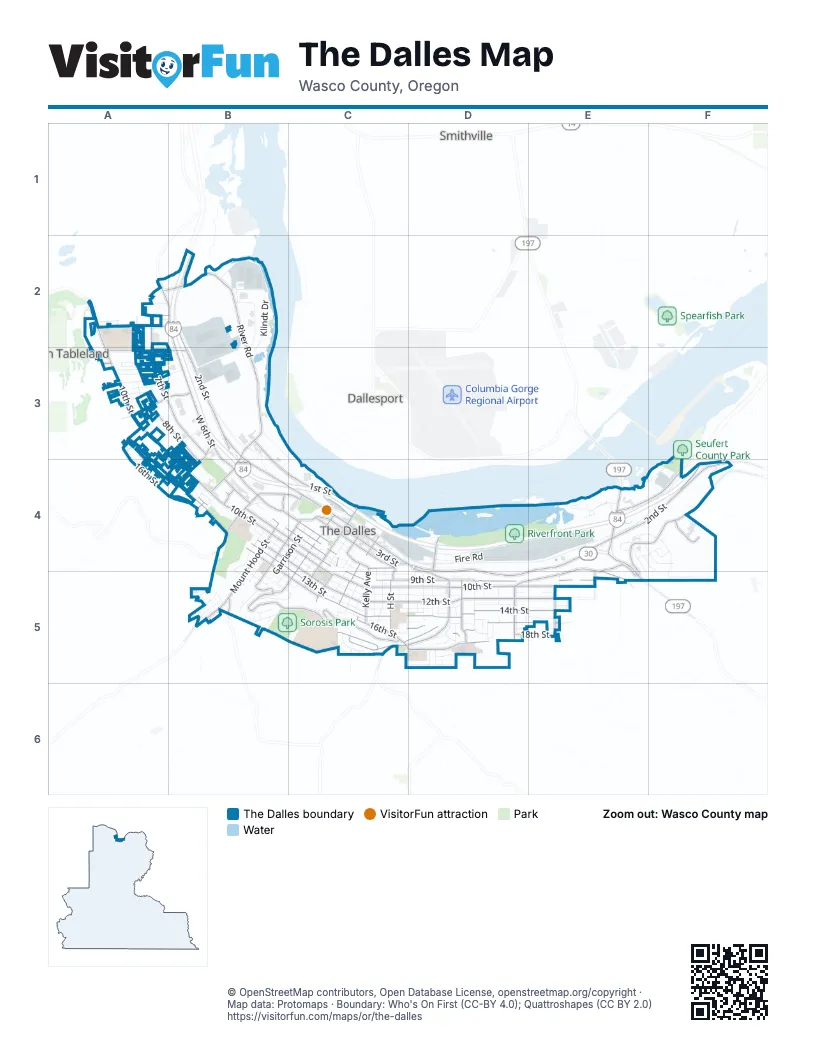
Street index of The Dalles
Each street on the sheet and the grid squares it crosses.
- Cascade Court WestA2
- Cascade Street WestA2
- Chenoweth Loop RoadA2, B2
- Chenowith Creek RoadA2
- Division StreetA2
- Haven WayA2
- Highway 30A2
- Irvine Street WestA2, B2
- Lee StreetA2, B2
- River RoadA2, B2, B3
- Sara CourtA2
- Tyler CourtA2
- West 10th StreetA2, A3, B3, B4, C4
- West 6th StreetA2, B2, B3, B4, C4
- West 7th StreetA2, A3, B3, C4
- West 8th StreetA2, A3, B3, B4, C4
- West 9th StreetA2, A3, B3, B4, C4
- Columbia River HighwayB2, B3, B4, C4, D4, E4, F4
- Columbia RoadB2
- Crates WayB2, B3
- Klindt DriveB2, B3
- River Trail WayB2
- Steelhead WayB2
- West 2nd StreetB2, B3, B4, C4
- Amanita WayA3
- Button CourtA3
- Chantrelles LaneA3
- Elberta Street WestA3, A4
- Emerson Street WestA3
- Fallon WayA3
- Floral Court WestA3
- Floral StreetA3
- Garden Court WestA3
- Gordon CourtA3
- Heritage LoopA3
- Heritage WayA3
- Home Court WestA3
- Home StreetA3
- Honey Do StreetA3
- Hostetler Way WestA3, B3
- Lillian WayA3, B3
- Lorenzen StreetA3
- Meadow WayA3
- Meek StreetA3
- Morrel DriveA3
- Myrtle Street WestA3, B3, A4
- Pleasant Court WestA3, B3
- Pomona Street WestA3, B3
- Richland Court WestA3
- Russula RoadA3
- Snipes StreetA3, B3
- Snipes Street WestA3, B3
- Stoffer LaneA3
- Verdant Street WestA3
- West 11th StreetA3, B4, C4, C5
- West 13th StreetA3, A4, B4, C5
- West 14th StreetA3, A4, B4, C5
- Ash Street WestB3
- Bargeway RoadB3, C4
- Kingsley StreetB3, B4
- Kingsley Street WestB3, A4
- Terminal AvenueB3, B4
- Walnut Street WestB3, B4
- Webber StreetB3, B4
- West 1st StreetB3, B4, C4
- West 9th PlaceB3, B4
- West 12th StreetA4, B4, C4, C5
- West 15th StreetA4, B4, B5, C5
- West 16th StreetA4, B4, B5, C5
- Blakely DriveB4
- Blakely WayB4
- Bridge StreetB4, B5
- Chenoweth StreetB4
- Cherry Heights RoadB4, C4
- Eric Court WestB4
- Frost Court WestB4
- Garrison StreetB4, C4, B5
- Jordan StreetB4, B5
- Mount Hood StreetB4, B5
- Perkins Street WestB4
- Sandy Street WestB4
- Terminal StreetB4
- Terminal WayB4, C4
- Trevitt StreetB4, C4, B5
- Vey WayB4
- West 18th StreetB4, B5
- West 8th PlaceB4
- Wright StreetB4, B5
- Case StreetC4
- Court StreetC4, C5
- East 10th StreetC4, C5, D5, E5
- East 1st StreetC4
- East 2nd StreetC4, D4, E4, F4, D5
- East 3rd StreetC4
- East 4th StreetC4, C5
- East 5th StreetC4
- East 6th PlaceC4
- East 7th PlaceC4
- East 7th StreetC4
- East 8th PlaceC4
- East 8th StreetC4, C5, D5
- East 9th PlaceC4
- East 9th StreetC4, C5, D5, E5
- East AlleyC4
- F StreetC4, C5
- Federal StreetC4, C5
- Fire RoadC4, D4, E4
- G StreetC4, C5
- Jefferson StreetC4, C5
- Kelly AvenueC4, C5
- Laughlin StreetC4, C5
- Liberty StreetC4, C5
- Lincoln StreetC4, B5, C5
- Madison StreetC4, C5
- Monroe StreetC4
- Pentland StreetC4, B5
- Taylor StreetC4
- Union StreetC4, C5
- Washington StreetC4, C5
- West 2nd PlaceC4
- West 3rd PlaceC4
- West 3rd StreetC4
- West 4th StreetC4
- West 5th PlaceC4
- Boat Launch RoadD4
- Brewery GradeD4, D5
- Brewery Overpass RoadD4
- Riverfront Park RoadD4
- Tie Plant RoadD4, E4
- Blue Heron CourtE4
- Brentwood DriveE4, F4
- Bret Clodfelter WayE4, F4
- Columbia View DriveE4, F4, E5
- Eagle Crest DriveE4
- East Knoll CourtE4
- East Knoll DriveE4
- Fremont Street EastE4, E5
- Honeysuckle LaneE4
- Indian RoadE4, F4
- Lone Pine BoulevardE4
- Lone Pine DriveE4
- Old Dufur RoadE4, D5, E5
- Osprey Lane EastE4
- Richmond Street EastE4, E5
- Royal Crest DriveE4, F4
- Sherman DriveE4, F4
- Southshore AvenueE4
- Southshore LaneE4
- Summit Ridge DriveE4, F4
- The Dalles BridgeE4
- The Dalles-California HighwayE4, E5
- Wasco DriveE4, F5
- Crest CourtF4
- Fifteenmile RoadF4
- Veterans DriveF4
- Viewpoint RoadF4
- Bennet WayB5
- Denton StreetB5
- Ericksen WayB5
- Grant CircleB5
- Liberty WayB5, C5
- Lincoln WayB5
- Mill Creek RoadB5
- Park PlaceB5
- Radio WayB5
- Skyline RoadB5
- Sorosis StreetB5
- Sunset Valley DriveB5
- West 17th StreetB5
- West 19th StreetB5
- West 20th StreetB5
- West 21st PlaceB5
- West 21st StreetB5
- West 22nd StreetB5
- West 23rd StreetB5, C5
- West 25th StreetB5
- West Scenic DriveB5, C5
- West Wright StreetB5
- Wright DriveB5
- Dry Hollow RoadC5, D5
- East 11th StreetC5, D5, E5
- East 12th StreetC5, D5, E5
- East 13th PlaceC5, D5
- East 13th StreetC5, D5, E5
- East 14th StreetC5, D5, E5
- East 15th PlaceC5
- East 15th StreetC5, D5, E5
- East 16th StreetC5, D5, E5
- East 17th StreetC5, D5, E5
- East 18th StreetC5, D5, E5
- East 19th StreetC5, D5
- East 20th StreetC5, D5
- East 21st PlaceC5
- East 21st StreetC5, D5
- East Scenic DriveC5
- Esther WayC5
- Fairview StreetC5
- H StreetC5
- I StreetC5
- J StreetC5, D5
- Riverview StreetC5
- Scenic View LaneC5
- Short StreetC5
- Terrace DriveC5
- Terrace StreetC5
- Clark StreetD5
- Claudia LaneD5
- Cliff StreetD5
- East 14th PlaceD5
- Golden WayD5
- Harris StreetD5
- Lewis StreetD5
- Minnesota StreetD5
- Montana StreetD5
- Nevada StreetD5
- Oakwood DriveD5
- Oregon StreetD5
- Quinton StreetD5
- Roberts StreetD5
- Shearer StreetD5
- Thompson StreetD5
- View CourtD5
- Lambert StreetE5
- Morton StreetE5
- Morton Street EastE5
Places on the map
- A OK Pak & Ship
- Aaron's
- Adventist Health Columbia Gorge
- Allen's Food Center
- Amphitheater
- Anderson Homestead
- Astro Mart
- Bank of America
- Bargeway Pub
- Bi-Mart
- Big 5 Sporting Goods
- BMO
- Budget Inn Motel
- Burger King
- Burgerville
- Calvery Baptist Church
- Casa El Mirador
- Cascade Car Wash
- Celilo Inn
- Center Market 12th Street
- CGCC Workforce Center
- Chenoweth Elementary School
- City Park
- Coastal Farm and Ranch
- Dry Hollow Elementary School
- Fred Meyer
- Independent Order of Odd Fellows Cemetery
- Kramer Field
- NORCOR
- Port of The Dalles Marina
- Riverfront Park
- Saint Peters Cemetery
- Shilo Inn
- Sorosis Park
- The Dalles Commercial Historic District
- The Dalles High School
- The Dalles Middle School
- The Dalles NRHP
- Thompson Park
- Union Pacific Railroad Co. Tie-Treating Plant Superfund Site
Next to The Dalles
- Chenoweth Tableland
- Dallesport
- Smithville
© OpenStreetMap contributors, Open Database License, openstreetmap.org/copyright · Map data: Protomaps · Boundary: Who's On First (CC-BY 4.0); Quattroshapes (CC BY 2.0)















