

Oregon map
Wasco County map
About 26,507 people live here (Census Bureau, 2024 estimate). The sheet's index lists 300 streets; The Dalles-California Highway, Main Street and Columbia River Highway cross the most grid squares. Things to do inside the boundary: Columbia Gorge Discovery Center & Museum, Deschutes River Adventures and River Drifters.
Open the map (PDF, US Letter)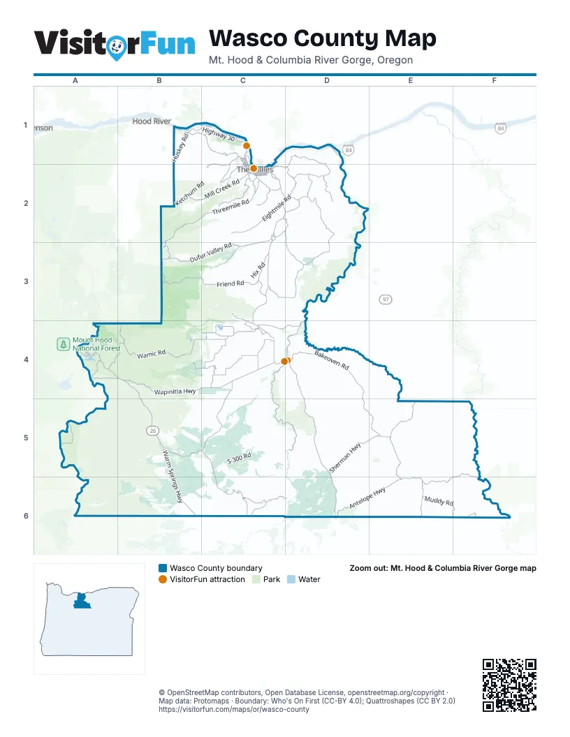
Maps inside Wasco County
1 map inside, from the street map of Wasco County down.
Street index of Wasco County
Each street on the sheet and the grid squares it crosses.
- Columbia River HighwayB1, C1, D1, C2
- Mosier-The Dalles HighwayB1
- The Dalles-California HighwayC2, D2, C3, C4, D4, D5, D6
- Warm Springs HighwayA4, B4, B5, B6
- Wapinitia HighwayB4, C4
- Sherman HighwayD5, E5
- East 2nd StreetC2
- West 2nd StreetC1, C2
- E StreetE5
- The Dalles BridgeC2
- East 3rd StreetC2
- Lincoln StreetC2
- Deschutes AvenueD4
- Brewery Overpass RoadC2
- West 3rd StreetC2
- Mill Creek BridgeB6
- Bakeoven RoadD4, D5, E5
- Shaniko-Fossil HighwayE5, F5, E6, F6
- Wamic RoadB4
- Dufur Valley RoadC2, B3, C3
- Antelope HighwayD6, E6
- Sherars Bridge HighwayC4, D4
- Cherry Heights RoadC2
- Chenowith Creek RoadC1, C2
- Wamic Market RoadC4
- Seven Mile Hill RoadC1
- State RoadB1, C1
- Dry Hollow RoadC2
- Rock Creek Dam RoadB4, C4
- West 10th StreetC1, C2
- Celilo-Wasco HighwayD1
- West 6th StreetC1, C2
- East 10th StreetC2
- Tygh Valley RoadC4
- River RoadC1
- Sherar's Bridge HighwayD4
- East 16th StreetC2
- Main StreetB1, C2, C4, E5, E6
- Court StreetC2
- 1st AvenueB1
- Webber StreetC1, C2
- 3rd AvenueB1
- Washington StreetB1, C2
- Dufur Bypass RoadC2
- Chenoweth Loop RoadC1
- South StreetE6
- East 7th StreetC2
- Kelly AvenueC2
- Brewery GradeC2
- Heimrich StreetC2
- Northeast 5th StreetC2
- Terminal StreetC2
- Deschutes River Access RoadC4, D4, C5, D5
- Skyline RoadB2, C2, A4, A5
- Eightmile RoadC2, D2
- Highway 30B1, C1
- Simnasho-Hot Springs RoadC5, C6
- Threemile RoadC2, C4
- Muddy RoadE6, F6
- Fifteenmile RoadD1, C2, D2
- Victor RoadC4
- Mill Creek RoadB2, C2
- Tygh Ridge RoadC3, D3
- Emerson Loop RoadD2
- Friend RoadB3, C3
- Smock RoadB4, C4
- Wrentham Market RoadD2
- Forest Road 2730B3
- Bureau of Indian Affairs Road 3C5
- Warm Springs RoadC6, D6
- Center Ridge RoadD2, D3
- Dufur Gap RoadC3
- Juniper Flat RoadC4
- Simnasho RoadB5, C5
- Long Hollow RoadD2, D3
- Fifteen Mile RoadD2
- Cold Camp RoadE6
- Cedar Burn RoadA4, B4
- Forest Road 1720B2, B3
- Five Mile RoadC2
- Forest Road 2630A4
- Boyd Loop RoadC2, D2
- Dodson RoadC4
- S-507A RoadA4, B4
- Forest Road 4430B2, B3
- Reservation RoadC4, C5
- White River Crossing RoadC4
- Shadybrook RoadC3, C4
- Ka-Nee-Ta Simnasho RoadC6
- Webster Flat DriveC6
- Browns Creek RoadC2
- Ward RoadD2
- Fairgrounds RoadC4
- South Valley RoadC3
- Old Dufur RoadC2
- Steele RoadC2
- Ross RoadC4
- Kelly Cutoff RoadD2
- East 12th StreetC2
- F. A. Morrow RoadC4
- West 13th StreetC1, C2
- East 14th StreetC2
- Columbia View DriveC2
- West 8th StreetC1, C2
- Forest Road 4420B3
- East 9th StreetC2
- West 7th StreetC1, C2
- West 1st StreetC2
- East 19th StreetC2
- Rock Creek RoadB1
- East 18th StreetC2
- West 9th StreetC1, C2
- East Scenic DriveC2
- Mount Hood StreetC2
- West Scenic DriveC2
- West 14th StreetC2
- Union StreetC2, E6
- Marsh Cutoff RoadC1
- West 12th StreetC1, C2
- Bret Clodfelter WayC2
- Three Mile RoadC2
- Olney RoadC2
- Irvine Street WestC1
- Hostetler Way WestC1
- Oregon StreetB1, C2
- North Pine Hollow Access RoadC4
- Trevitt StreetC2
- Laughlin StreetC2
- East 4th StreetC2
- Northeast 1st StreetC2
- H StreetC2
- Thompson StreetC2
- Discovery DriveC1
- Walnut Street WestC2
- Morton Street EastC2
- Snipes Street WestC1
- Fremont Street EastC2
- Veterans DriveC2
- Verdant Street WestC1, C2
- Richmond Street EastC2
- Snipes StreetC1
- West 4th StreetC2
- ReservationC4
- West 3rd PlaceC2
- Vey WayC2
- Lincoln WayC2
- Oak Grove AvenueC4
- Emerson Street WestC1
- South Junction RoadD5, D6
- Pleasant Ridge RoadC2
- Forest Road 4811B3, B4
- Roberts Market RoadD2
- S-300 RoadC5
- Forest Road 27B3, C3
- S-200 RoadC5, D5, D6
- Forest Road 2710B3, C3, B4
- Ketchum RoadB2, C2
- Mosier Creek RoadB1, B2
- Upper Five Mile RoadB2, C2
- Old Wapinitia RoadC4
- Rail Hollow RoadC2, C3
- Pine Hollow RoadC2
- Huskey RoadB1
- Forest Road 2660A4
- Ward Mill RoadC2
- Old Moody RoadD1
- Frog Creek RoadA4, B4
- Forest Road 4810B4
- Easton Canyon RoadD2, D3
- Upper Tub Springs RoadE6
- Japanese Hollow RoadC2
- Forest Road 4880B4
- Forest Road 2610A4
- B-180 RoadA5, B5
- Hastings Ridge RoadD2, D3
- Steuber RoadD2, D3
- Forest Road 4820B4
- Lower Tub Springs RoadE6
- Obrist RoadB2, C2
- B-100B5, B6
- Winslow RoadC3
- Forest Road 4890B4
- Dry Creek RoadB1, C1
- Badger Creek RoadC3, C4
- B-100 RoadB6
- Bennett RoadE5, E6
- Barlow RoadA4, B4
- Wilson RoadB1, D4
- East Wapinitia RoadC4
- Carroll RoadB1
- S-450 RoadB5, B6
- Forest Road 2110B4
- Hinton RoadD4, E4, D5, E5
- Hix RoadC3
- Forest Road 4830B4
- Forest Road 4330B4
- Fax RoadD2
- Godberson RoadB1, B2
- McCoy RoadD2
- Forest Road 2131B4
- B-210 RoadB6
- Forest Road 4860B4
- Adkisson RoadD2
- Jewel RoadB2, C2
- Heberlein RoadC3
- Natural Pasture RoadC4
- Fargher RoadC2, D2, C3
- Forest Road 2640A4
- Oak Springs RoadC4, D4
- Mason RoadD2
- Walters RoadB4, C4
- Forest Road 4310A4, B4
- Kelly Springs RoadB4, B5
- Forest Road 4814B4
- Dutch Flat RoadC2
- Wolf Run RoadC3
- S-310 RoadC5
- Zen RoadF6
- B-160 RoadB6
- Oak Flat RoadC2
- Forest Road 4290A4
- Forest Road 4885B4
- Old Dufur South RoadC2
- E-150 RoadC6
- Bureau of Indian Affairs Road 35A5, B5
- Forest Road 4881B4
- Company Hollow RoadD1, D2
- Kingsley RoadC3
- J Hix RoadC3
- Forest Road 1711B2
- Back Walters RoadC4
- Keeps Mill RoadB4
- Sand RoadD3, D4
- Endersby RoadB4
- Woodcock RoadC4
- Osborn Cutoff RoadB1, C1
- B-140 RoadB6
- Benson RoadC2
- Freebridge RoadD2
- East 13th StreetC2
- Hulse RoadC3
- Springer Mill RoadC3
- Orchard RoadC2
- Elliott RoadC3
- Tub Spring LoopE6
- Claymier LaneC4
- Vensel RoadB1, C1, C2
- Price RoadC4
- Kelly CutoffC4
- Shell Rock RoadC3
- Sandlin RoadC1, C2
- Proctor RoadB1
- Pole RoadC3
- Endersby CutoffC2
- Ridgetop Road NorthC3
- Forest Road 4240110A5
- Driver RoadC4
- S-115 RoadC6
- Walton Grade RoadC2
- Japanese Hollow CutoffC2
- Fred Ashley RoadC4
- Forest Road 4891B4
- Morgansen RoadB1, C1
- Fire RoadC2
- Forest Road 240A4
- Wells RoadC2
- Dell RoadC1
- Delore RoadC4
- Valley DriveC3
- Rowena River RoadC1
- South Lakewood RoadC4
- East 11th StreetC2
- Ridgtop Road SouthC3
- Fulton RoadD2
- Old Friend RoadC3
- Forest Road 2110-230B4
- Hood River RoadB1
- Earl Crabtree RoadC4
- Paulson RoadC4
- East 15th StreetC2
- Burtner RoadC2, C3
- Behrens RoadB1
- Dell Vista DriveC1
- Nirvana RoadF6
- Tie Plant RoadC2
- Dolan RoadC2
- Ridgetop RoadC3
- Knob Hill RoadC2
- Rattler Ridge RoadB1
- Digger RoadB1
- Wrentham Cutoff RoadD2
- Campbell LaneC4
- Conroy RoadD4
- Muller RoadC4
- Seven Mile High RoadC1
- Forest Road 4440B3
- Ayres RoadC4
- South Pine Hollow Access RoadC4
- West 16th StreetC2
- Paradise Ridge RoadC1
Things to do on the Wasco County map
Places on the map
- Antelope
- Badger Creek Wilderness
- BLM Criterion Tract
- BSA Camp Baldwin
- Camas Prairie
- Clear Lake
- Crow Creek Reservoir
- Deschutes River State Scenic Waterway
- Dufur
- Four Sisters Natural Area
- Kah-Nee-Ta Hot Spring Resort
- Lake Bonneville
- Lower Deschutes River (BLM)
- Lower Deschutes Wildlife Area - Woosley Tract
- Lower White River Wilderness
- Maupin
- Mayer State Park
- Memaloose State Park
- Mill Creek Ridge Preserve
- Mosier
- Mount Hood National Recreation Area
- Mutton Mountains
- Pine Hollow
- Pine Hollow Reservoir
- Priday Ranch
- Riverfront Park
- Rock Creek Reservoir
- Rowena
- Shaniko
- Simnasho
- Smock Prairie
- The Dalles
- The Dalles NRHP
- Tom McCall Preserve at Rowena
- Tooley Lake
- Tygh Valley
- Wamic
- Warm Springs River
- White River Wildlife Area
Next to Wasco County
- Hood River
- Stevenson
© OpenStreetMap contributors, Open Database License, openstreetmap.org/copyright · Map data: Protomaps · Boundary: Who's On First (CC-BY 4.0); Quattroshapes (CC BY 2.0)















