

Oregon map
West Linn map
About 26,597 people live here (Census Bureau, 2024 estimate). The sheet's index lists 300 streets; Willamette Falls Drive, Willamette Drive and Sunset Avenue cross the most grid squares. Things to do inside the boundary: Historic Willamette District.
Open the map (PDF, US Letter)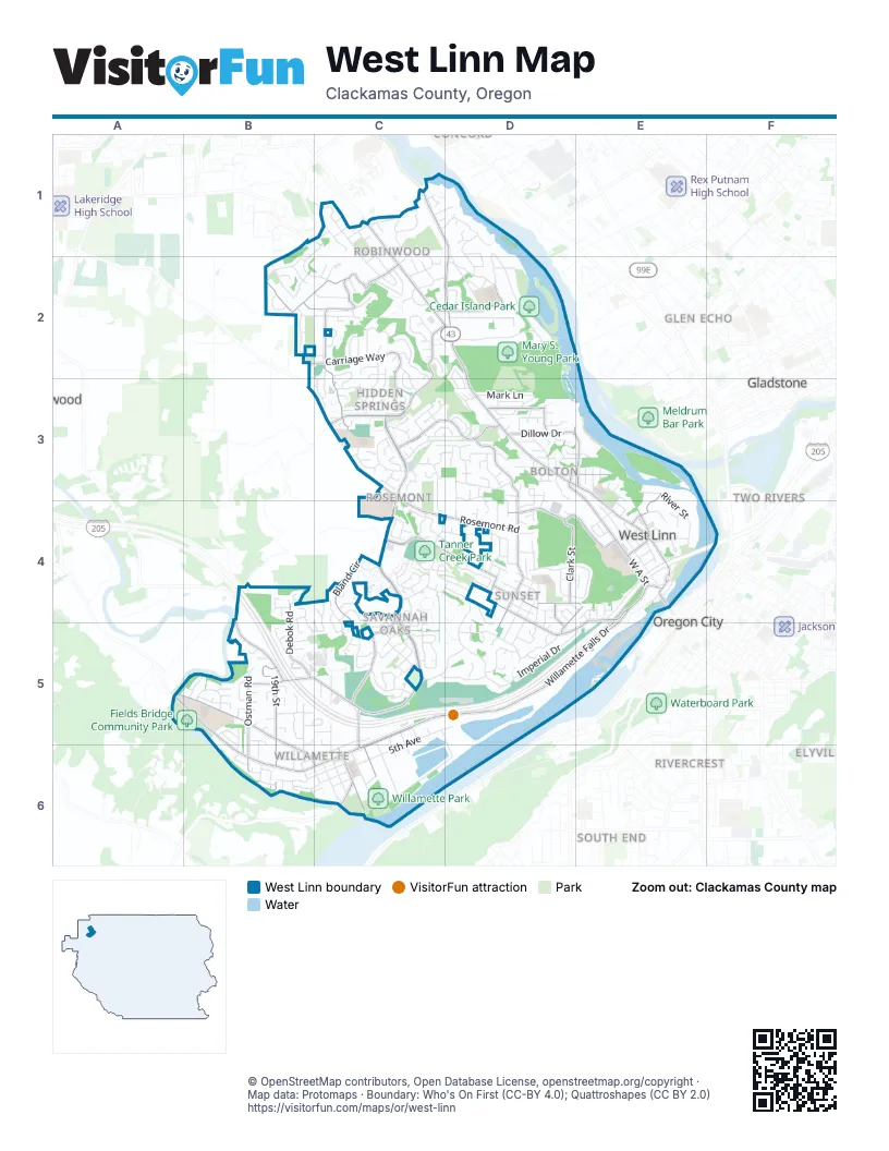
Street index of West Linn
Each street on the sheet and the grid squares it crosses.
- Abernethy BridgeE4, F4
- Willamette DriveC1, C2, D2, D3, E3, E4
- Pacific HighwayC1
- Willamette Falls DriveE4, A5, B5, C5, D5, E5, B6, C6
- Salamo RoadC3, C4, C5
- Rosemont RoadC3, C4, D4
- Hidden Springs RoadC2, D2, C3
- Sunset AvenueD4, E4, D5, E5
- Summit StreetD3, D4
- Santa Anita DriveC3
- 10th StreetC5, C6
- Cornwall StreetD4, D5
- Oregon City BridgeE4
- Southwest Borland RoadA5
- Marylhurst DriveB2, C2
- Carriage WayB2, C2, C3
- Parker RoadC4, D4
- Dollar StreetA5, B5, B6, C6
- Old River DriveC1, D1, D2
- Pimlico DriveC3, D3
- Suncrest DriveC2, C3
- West A StreetD3, E3, E4
- 19th StreetB5, B6
- Skyline DriveD4, E4
- Bland CircleC4, C5
- Blankenship RoadB5, C5
- Ostman RoadB5, B6
- Cedaroak DriveC2, D2
- Clark StreetD4
- Hillcrest DriveB2, C2
- Debok RoadB4, B5
- Tannler DriveC5
- Johnson RoadB4, B5
- Buck StreetD3, E3
- 12th StreetC6
- Dillow DriveD3, E3
- Failing StreetD3, E3
- Jolie Pointe RoadD3
- Lancaster StreetD4
- Burns StreetE3, E4
- Long StreetD4, E4
- Riverview AvenueD4, E4, D5
- Hood StreetE4
- McKillican StreetE4
- Larson AvenueD3
- Tualatin AvenueC6
- Chestnut StreetE4, E5
- Elliott StreetD3
- Simpson StreetD4
- Southwest Petes Mountain RoadC6
- Tumwater StreetD4, D5
- Old River RoadC1
- Beacon Hill DriveD4, D5
- Wildwood DriveC2, C3
- 5th AvenueC5, D5, C6
- Volpp StreetC6, D6
- Horton RoadC3, D3
- Coeur d'Alene DriveC4, C5
- Imperial DriveD5, E5
- Arbor DriveC1
- Mapleton DriveD2
- Broadway StreetE4
- Apollo RoadC3, D3
- Elmran DriveD2
- Ridge LaneC4, D4
- Fairhaven DriveD5
- Nixon AvenueD1, D2
- River StreetE3, E4
- Calaroga DriveD1, D2
- Skye ParkwayB1, C1, B2, C2
- Upper Midhill DriveC1, C2
- 13th StreetC5, C6
- Killarney DriveB4, C4, B5, C5
- Winkel WayC4, D4
- Cascade TerraceC4, C5
- Palomino WayC3, D3
- 16th StreetB5, B6
- Summerlinn DriveB5, C5
- Kenthorpe WayD2
- Stonehaven DriveB2
- Valley View DriveB2, C2
- Skyview DriveC4
- Derby StreetC2, C3
- Trillium DriveD1, D2
- Chelan DriveC4
- Remington DriveC5
- Sussex StreetD4, D5
- Wilderness DriveC2
- Crestview DriveC4, C5
- Barrington DriveC5, D5
- Bellevue WayC2, C3
- Windsor TerraceD4, E4
- 8th AvenueC5, B6, C6
- Alpine DriveC4, C5
- Chelan LoopC4
- View DriveC2
- Churchill Downs DriveC3
- Sabo LaneC4, D4
- Mark LaneD3
- 9th StreetC5, C6
- West Bluff DriveC4
- Riverview DriveD5
- Greene StreetC5
- Ponderay DriveC4
- Exeter StreetD4, D5
- 14th StreetC6
- Rogue WayC5
- Wellington DriveD5
- 6th AvenueB6, C6
- Knapps AlleyB6, C6
- Hillside DriveC1
- Mill StreetE4, E5
- Summerlinn WayC5
- Norfolk StreetD4, D5
- Barnes CircleC5
- Riverknoll WayC5, D5
- Sun CircleC2
- Fairview WayC1, C2
- Falcon DriveC5
- Weatherhill RoadC4
- Rosepark DriveD3, D4
- River Heights CircleB5
- Pimlico TerraceD3
- Bay Meadows DriveC3
- Caufield StreetD3
- Oregon City BoulevardD4
- Wild Rose DriveC4
- Lower Midhill DriveC1, C2
- Roxbury DriveC4, D4
- Shannon LaneD3, D4
- White Cloud CircleD2, D3
- Troon DriveB2
- Warwick StreetD4
- Haskins RoadC5
- 11th StreetC6
- Tulane StreetD3
- Kapteyns StreetB2
- Sunburst TerraceC2, C3
- York StreetD4
- Hidden Springs CourtC3
- Coho LaneD4
- Perrin StreetE3, E4
- Wild Rose LoopC4
- Calaroga CircleD1, D2
- Serango DriveD3
- Miles DriveC3, C4
- Ponderosa LoopC4, C5
- Jamie CircleB5, C5
- Hunter WayC3
- Tompkins StreetD3, E3
- Sylvan WayC2
- Horizon DriveC4
- Club House DriveC3
- Lorinda LaneD4, D5
- Appaloosa WayC3
- Holly StreetE4
- Holmes StreetE3
- Short StreetB5
- Margery StreetB5
- Vista Ridge DriveC5
- Brandon PlaceA5, B5
- Noble LaneC4
- Kimberly DriveB6, C6
- Randall StreetD3
- Michael DriveB5
- Swiftshore DriveB6
- Ridgebrook DriveC2
- Territorial DriveE4
- Cheryl DriveB6
- Oregon City LoopD4
- Marylwood CourtC2
- Hillhouse DriveB5
- Bennington CourtC3
- Bridgeview DriveD3, D4
- Midhill CircleC2
- Landis StreetD4, D5
- Palomino CircleD3
- Walling WayC2, D2
- Oxford StreetD4
- Bluegrass WayC2, C3
- Ridgewood WayD2
- Southslope WayD5
- 4th StreetC5, D5, D6
- 4th AvenueC6
- Walling CircleC2
- Club House CircleC3
- Spring Ridge DriveC2, C3
- Prospect StreetD4
- Marylhurst CircleB2
- Heron DriveC4
- Hoodview AvenueC4
- Saddle CourtC3, D3
- Rainier PlaceD3
- Crescent DriveC4, D4
- Shady Hollow WayC1
- Glen TerraceD2
- Artemis LaneC3, D3
- Meadowlark DriveC4
- Springtree LaneB5, C5
- First CourtE4
- Lafave StreetD3
- Cambridge StreetD4
- Ascot CircleC2, C3
- Webb StreetE4
- Day RoadC4
- Evergreen DriveD3
- Conestoga LaneC3
- Sunray CircleC3
- Robin CircleC2, D2
- Furlong DriveC3
- Epperly WayB5
- Robinwood WayC1, C2
- Cascade StreetE4
- Charman StreetD4
- Joseph Fields StreetB5, B6
- Lowry DriveD3
- Terrace DriveE4
- Nicole DriveB5
- Ireland LaneD4
- Maple TerraceD3
- Britton StreetB6
- Zeus DriveD3
- 7th StreetC5, C6
- Belmont WayC3
- Bronco CourtC3
- Kantara WayC2
- Kensington CourtC5
- Willamette View CourtD3
- Swiftshore CircleB6
- Athena RoadD3
- Quail Ridge CourtC4, D4
- Larkspur LaneD3
- Snidow DriveB6
- Barclay StreetD3
- Grove StreetE4
- Club House CourtC3
- Amy StreetE4
- Lexington TerraceC2
- Buse StreetE4
- Fernvilla DriveC1, D1
- Meridian CircleC3
- Bexhill StreetB5, B6
- Bonnet DriveD4
- Evah LaneB6, C6
- Meek WayB5, B6
- 8th StreetC5, C6
- Tamarisk DriveB4
- Surrey LaneC2, C3
- Hall StreetC5
- Hughes DriveD3
- Nolan LaneB5
- Preakness DriveC3
- Taylor DriveC5
- Linn LaneD4
- River Woods PlaceC1, D1
- Cottonwood CourtC2
- Beacon Hill LaneD4
- Hillcrest CourtC2
- Sinclair StreetE4
- Sunbreak LaneC5
- Hillside CourtC1
- Riverknoll CourtD5
- Robin View DriveC1, D1
- Belknap DriveC4
- Bittner StreetD4
- Munger DriveD3
- Windham Oaks CourtD3
- Barlow StreetD3
- Donegal CourtB4, B5
- White Tail DriveD3
- Fircrest DriveC4
- Crown StreetD4, E4
- Fields DriveB5
- Rosemarie DriveB5
- Grant StreetD4, D5
- Braemar DriveB2
- Peregrine CourtC3
- College Hill PlaceC1
- Firwood DriveD3, D4
- Calaroga CourtD1
- Haverhill CourtC3
- Alder CourtE4, E5
- Easy StreetE4
- Farrview CourtB5
- Walnut StreetE4
- 15th StreetB6, C6
- Nomie WayC4, D4
- Snowberry Ridge CourtC5
- Gloria DriveD4
- Horton CourtD3
- Timothy LaneC5
- Limerick LaneB4
- Ann CourtB5
- Rawhide StreetC2
- Kantara CourtC2
- West Bluff CourtC4
- Bluegrass CircleC3
- Vista CourtC2
- Geer StreetE3
- Parkside CourtD3, E3
Things to do on the West Linn map
Places on the map
- Athey Creek Middle School
- Barrington Heights
- Bernert Landing Boat Ramp
- Bolton
- Burnside Park
- Camassia Natural Area
- Canal Basin
- Cascade Summit Town Square
- Cedar Island Park
- Cedaroak Boat Ramp
- Cedaroak Park Primary School
- Fields Bridge Community Park
- Hammerle Park
- Hidden Springs
- Hidden Springs Open Space
- Interstate Tractor Open Space
- Maddax Woods
- Mary S. Young Park
- Marylhurst
- Marylhurst Heights Park
- Midhill Park
- New Life Church
- Off Leash Area
- Oppenlander Athletic Fields
- Parker Crest
- Robinwood
- Rosemont Summit
- Savanna Oaks
- Skyline Ridge
- Sunset
- Swift Shore Open Space
- Tanner Creek Park
- Tanner Open Space
- The White Oak Savanna
- Tualatin River Open Space
- West Linn High School
- Willamette
- Willamette Falls Locks
- Willamette Historic District
- Willamette Park
Next to West Linn
- Canemah
- Elyville
- Gladstone
- Glen Echo
- Glenmorrie
- Jennings Lodge
- McLoughlin
- Mount Pleasant
- Oregon City map
- Rivercrest
- South End
- Two Rivers
© OpenStreetMap contributors, Open Database License, openstreetmap.org/copyright · Map data: Protomaps · Boundary: Who's On First (CC-BY 4.0); Quattroshapes (CC BY 2.0)















