

Pennsylvania map
Greensburg map
About 14,586 people live here (Census Bureau, 2024 estimate). The sheet's index lists 300 streets; Harvey Avenue, West Otterman Street and College Avenue cross the most grid squares. Also on it: Mt. Odin Golf Course, Lynch Field Park and Seton Hill University.
Open the map (PDF, US Letter)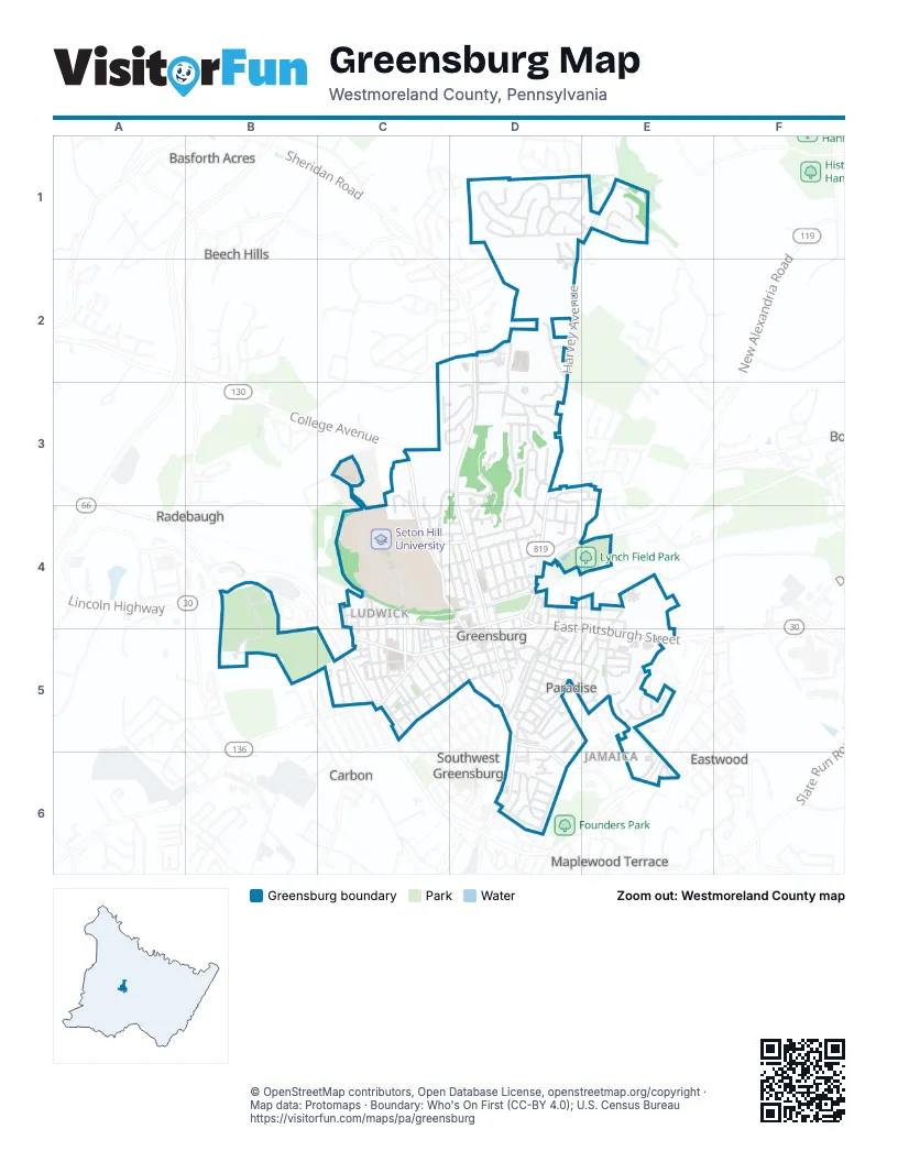
Street index of Greensburg
Each street on the sheet and the grid squares it crosses.
- Lincoln HighwayC5
- East Pittsburgh StreetD4, D5, E5
- West Otterman StreetC4, D4, C5, D5
- West Pittsburgh StreetC5, D5
- Arch AvenueD4
- South Main StreetD4, D5
- West Newton StreetC5
- East Otterman StreetD4
- Beacon StreetD4
- New Alexandria RoadD4
- North Spring StreetC4, C5
- West Newton RoadC5
- South Spring StreetC5
- Harvey AvenueD1, E1, D2, D3, D4
- North Main StreetD2, D3, D4
- College AvenueC3, C4, D4, D5
- Clopper StreetC4, D4
- Humphrey RoadE5
- Tollgate Hill RoadB4
- Highland AvenueD4, D5, D6
- Mount Pleasant StreetD5, D6
- Highland StreetD6
- Seton Hill DriveC3, C4, D4
- Brattleboro DriveD1, E1
- North Maple AvenueD4, D5
- Mennel DriveD2, D3
- Glenview AvenueD3, D4
- Forest AvenueD3
- Northmont StreetD3, D4
- South Urania AvenueD4, D5
- Cabin Hill DriveD3
- Euclid AvenueD5, D6
- South Hamilton AvenueC5
- Stanton StreetC5, D5
- McLaughlin DriveD3
- Tremont AvenueD5
- North Pennsylvania AvenueD4
- Westminster AvenueC5, D5
- Southwest AvenueD5
- Yont WayD2
- New London DriveD1
- Sells LaneD5, E5, D6
- South Washington AvenueC5
- Foxglove DriveD1
- Teeter WayD4, D5
- John P Reese WayD4, D5
- Saybrook DriveD1, E1
- Kenneth StreetD4
- Harrison AvenueD4
- Union Cemetery RoadD4, E4
- Locust StreetD5, E5
- George StreetD4, E4
- Lane WayC5
- Hamel AvenueD5
- Old Salem RoadD2, D3
- Grant StreetD4
- Shearer StreetC5
- Mace StreetC5
- Stark LaneE5
- Oakland AvenueC5, D5
- Ridgeway StreetD5, E5
- Grove StreetC5
- Towne Square DriveE5, E6
- Meadow DriveD2
- Hudock WayD4
- West 3rd StreetC5, D5
- Westmoreland AvenueE4, E5
- Glenmeade RoadE1
- Rimrock RoadE1
- Park StreetD4
- Vine StreetD5, E5
- Hawksworth RoadC3, D3, C4
- Ludwick StreetC4
- Alexander AvenueC5
- Delbane WayD4, E4
- Jeffrey StreetE5
- South Maple AvenueD5
- South Pennsylvania AvenueD4, D5
- Brushton AvenueC4
- Cleveland StreetC5
- South Lincoln AvenueC5
- Steck StreetD5
- Walnut AvenueD4
- Fajt WayD4
- Johnston WayD6
- Center AvenueD4
- Madison AvenueC5
- Chestnut Hill DriveC3, D3
- Summit DriveD6
- Defloria WayD4, E4
- Willow AvenueD5, E5
- Culbertson AvenueD4
- Keystone StreetD6
- Meadowbrook AvenueD3
- Lemington StreetE5
- Rear Spring AlleyC5
- Morrison AvenueE5
- Jack StreetE4
- Laurel DriveE5
- Seminary AvenueC5, D5
- Alice CircleC3, D3
- South Spring AvenueC5
- Belmont AvenueD5
- Waverly DriveD3
- Concord AvenueC4, D4
- Laird StreetD5
- Fox Hill StreetD4
- Sheffield DriveD3, E3
- Barclay StreetC4, D4
- Holyoke DriveD1, E1
- North Hamilton AvenueC4, C5
- Orchard AvenueD6
- Bortz WayD4
- Myers WayC5
- Painter StreetC5
- Finfrock WayC5
- Cranston DriveD1
- Jefferson AvenueC4, C5
- Brown AvenueC4, D4
- Hillcrest DriveD6
- Holmes WayD4
- Moreland AvenueC3, D3
- Rohrer StreetC5, D5
- West 2nd StreetD5
- Bair WayD4
- Loor WayD4
- Depot StreetC4, C5
- Underwood AvenueD5, E5
- Danbury DriveD1
- Willy WayD5, E5
- Woodland AvenueD3
- Helen AvenueD3, D4
- Indiana AvenueD1
- Luzerne StreetD1, D2
- Franklin DriveD3
- Hope CourtC3, C4
- Hutchinson WayD4, D5
- Quincy DriveD1
- McArthur DriveE5
- Vermont AvenueC5
- Division StreetC4, C5
- Alwine AvenueD5
- Wilson AvenueD4
- West 4th StreetD5
- Ohara StreetC4, D4
- North Washington AvenueC4, C5
- Garden Center DriveD2
- Torrington DriveD1, E1
- Bella AvenueD4
- Eastmont DriveE5
- Fulton StreetD5
- Carpenter StreetC5
- Russell StreetC5
- Park LaneC3, C4
- Briar Hill DriveD6
- Ridge RoadE6
- Perry AvenueD5
- Goodwin AvenueE5
- Hawthorne AvenueC5, D5
- Tribune Review DriveD3, D4
- North Tremont AvenueD4
- Mount Thor RoadC3
- Hickory DriveE5
- Coshey WayC4
- Gather WayC4, C5
- Hammer WayC4, C5
- Westview DriveC5
- Grandview AvenueD6
- Treager WayD3
- Oakhill AvenueD3, D4
- Kenlane StreetD4
- Unity WayD5
- Redmerski WayD5
- Tunnel AvenueD4
- Foxglove Drive ExtendedD1
- Vannear AvenueD5
- Sycamore StreetD4
- North Lincoln AvenueC4
- Klines WayC4, C5
- Albert WayD4
- Edinboro DriveD3
- Florence StreetD4
- Clark StreetD4
- Kunkle DriveC3
- Oakhill LaneC3, C4
- Hudson AvenueD5
- Overly WayC4, C5
- Bach AvenueD5
- Chestnut StreetD5
- Stone StreetC5
- Sandstone RoadE1
- Tyger DriveD3
- Morningside DriveD3
- Farview DriveE6
- Krause WayC5
- Jean StreetD3, D4
- Morey PlaceC5, D5
- Fairmont StreetD6
- Felice WayC5
- Holloway WayC4, D4
- Barry CourtD3
- Brewery LaneD5
- Hancock AvenueC5
- Bush WayD6
- Bayard AvenueD3, D4
- Sidney StreetD5
- Dornin StreetD6
- North Urania AvenueD4
- Eicher AvenueD5
- North Carpenter StreetC4, C5
- Catherine StreetD5
- Wayne AvenueD4
- Plymouth StreetD6
- Stoden DriveD3
- Eastview AvenueD3
- Talbot AvenueD5
- Short StreetE5
- Evergreen AvenueD5, D6
- Thornton AvenueE5
- Dana DriveE5
- Cherry StreetC5
- Clyde AvenueE4
- Beechwood DriveD2
- Glenoak StreetD4
- Hampton StreetD5
- Adams StreetC5
- East 3rd StreetD5
- Liberty StreetC4, D4
- Truby StreetD5
- South StreetC5
- Reed AvenueC4
- Mechling WayC4, C5
- Moore AvenueC5, D5
- Oxford DriveE3
- Taylor StreetD5
- Turney StreetD5
- Wesbecher WayD5
- Landmark DriveE6
- Longview StreetD6
- Reamer StreetD6
- Greenmont StreetD6
- Lawnview WayD1
- Glen Cove RoadE1
- Hemlock StreetE5
- Rowe WayD5
- Shuey AvenueC4
- Tridico WayE4
- Winston WayD1
- Brady LaneC4
- Lynn-Lee StreetD3
- Bononi WayD5
- Hempfield StreetD5
- William AvenueD4
- Greenleaf AvenueD4
- Bel Air DriveD1
- Andress WayD4
- Lafayette StreetC5
- Northwood RoadE1
- Prestwick DriveD2, D3
- Ryan WayD5
- East 4th StreetD5
- Peterinelli WayD5
- Wilcox WayD4
- Beech StreetD3
- Mitinger AvenueD4
- Ruffner WayD6
- Sewickley StreetC5
- Gas AlleyC4, C5
- Jackson StreetC5
- Saint Clair AvenueD4, D5
- Hansen WayC5
- Keener WayE5
- Victoria DriveE5
- Beaver StreetD4
- Robert StreetE4, E5
- State StreetE5
- Borlin WayC4
- Ziff WayC5
- Shogan DriveD5
- Baughman StreetD4
- Bovard StreetC5
- Lear WayD5
- Petersburg TrailD4
- Seneca CourtE4
- Wood StreetD5
- Odinwood CourtC5
- Cambria CircleD2
- Everett StreetC4
- Somerset CourtD2
- Snite WayD5
- School AvenueD5
- Tower WayE6
- White StreetD5
- Silvis WayD6
- Markvue CircleC3, D3
- Oconell WayD4
- Angela DriveE4
- Spruce StreetE5
- Yard RoadD4
- Delmont StreetD4
Places on the map
- AAMCO
- Advance Auto Parts
- AutoZone
- Band Field
- Barnhart Funeral Home
- BearCom
- Blessed Sacrament Cathedral
- Calvary Chapel
- CentraTech Solutions
- Christ's Church
- Christian Layman Thrift Store
- Citgo
- Citizens Bank
- Community Living Care, Inc.
- Congregation Emanu-El Israel
- Coulter Park Baseball Court
- David Mateer Center for the Performing Arts
- Dino's Sports Bar
- Eighth Ward Basketball Court
- El Diablo
- Family Dollar
- First Church of God in Christ
- First Commonwealth Bank
- First Evangelical Lutheran Church
- Lynch Field Park
- Mt. Odin Golf Course
- Saint Clair Park
- Seton Hill University
- Westmoreland Hospital
Next to Greensburg
- Basforth Acres
- Beech Hills
- Carbon
- Eastwood
- Jamaica
- Maplewood Terrace
- Paradise
- Radebaugh
- Southwest Greensburg
- Stonevilla
© OpenStreetMap contributors, Open Database License, openstreetmap.org/copyright · Map data: Protomaps · Boundary: Who's On First (CC-BY 4.0); U.S. Census Bureau















