

Pennsylvania map
Indiana map
About 14,294 people live here (Census Bureau, 2024 estimate). The sheet's index lists 138 streets; Gompers Avenue, Nixon Avenue and Philadelphia Street cross the most grid squares. Things to do inside the boundary: Indiana County Tourist Bureau.
Open the map (PDF, US Letter)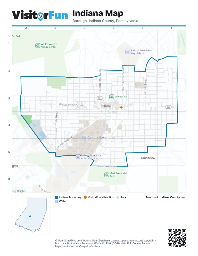
Street index of Indiana
Each street on the sheet and the grid squares it crosses.
- Chestnut StreetB2, C2, D2, E2, F2
- North 12th StreetB2, B3
- White Woods TrailB2
- Edgewood AvenueC2
- North 10th StreetC2, C3
- North 11th StreetC2, C3
- North Clymer AvenueC2, C3
- North Station AvenueC2, C3
- Pealer AvenueC2
- Stannard AvenueC2, D2, E2
- Croyland AvenueD2
- East Clark StreetD2, E2
- North 6th StreetD2, D3
- North 7th StreetD2, D3
- North 8th StreetD2, D3
- North 9th StreetD2, D3
- North Carpenter AvenueD2, D3
- Widdowson WayD2, E2
- Anderson AvenueE2, F2
- Douglas AvenueE2
- East Anderson AvenueE2
- East Charles StreetE2, F2
- East Olive StreetE2, F2
- East William StreetE2, F2
- North 3rd StreetE2, E3
- North 4th StreetE2, E3
- North 5th StreetE2, E3
- North AvenueE2
- North Coulter AvenueE2, E3
- North Taylor AvenueE2, E3
- Old Route 119 Highway NorthE2
- Queen LaneE2
- 1st StreetF2, F3
- Clairvaux DriveF2
- Gabriel AvenueF2, F3
- Gompers AvenueA3, B3, C3, D3, E3, F3
- Long AvenueA3
- Nixon AvenueA3, B3, C3, D3, E3, F3
- North 15th StreetA3
- North 16th StreetA3
- North Rex AvenueA3
- North Wine AvenueA3
- Philadelphia StreetA3, B3, C3, D3, E3, F3
- South 15th StreetA3, A4
- South 16th StreetA3
- South Rex AvenueA3, A4
- South WineA3, A4
- Water StreetA3, B3, C3, D3, E3, F3
- White AvenueA3
- Burns AvenueB3, C3, D3, E3
- North 13th StreetB3
- North 14th StreetB3
- North Fisher AvenueB3
- North Lowry AvenueB3
- Oak StreetB3, C3, D3, E3, F3
- South 12th StreetB3, B4
- South 13th StreetB3, B4, B5
- South 14th StreetB3, B4
- South Fisher AvenueB3, B4, B5
- South Lowry AvenueB3, B4
- Jimmy Stewart AvenueC3, D3
- North Foundry AvenueC3
- Shryock AvenueC3, D3, F3
- South 10th StreetC3, C4
- South 11th StreetC3, C4, C5
- South Clymer AvenueC3, C4
- South Foundry AvenueC3, C4
- South Paper Mill AvenueC3, C4
- Shyrock AvenueD3, E3
- South 6th StreetD3, D4, D5, D6
- South 7th StreetD3, D4, D5
- South 8th StreetD3, D4
- South 9th StreetD3, D4
- South Carpenter AvenueD3, D4, D5
- East Shyrock AvenueE3
- North Cherry AvenueE3
- South 3rd StreetE3, E4, E5
- South 4th StreetE3, E4, E5
- South 5th StreetE3, E4, E5
- South Cherry AvenueE3, E4
- South Coulter AvenueE3, E4, E5
- South Taylor AvenueE3, E4
- Wherle WayE3, E4
- East Oak StreetF3
- East Pike RoadF3
- North 2nd StreetF3
- North Gabriel AvenueF3
- North Walnut StreetF3
- South 1st StreetF3
- South 2nd StreetF3, F4
- South East AvenueF3, F4
- South Walnut StreetF3, F4
- Church StreetA4, B4, C4, D4, E4, F4
- Klondyke AvenueA4, B4, C4, D4
- McCreary DriveA4, B4, B5
- School StreetA4, B4, C4, D4, E4, F4
- Washington StreetA4, B4, C4, D4, E4, F4
- Elmer AvenueB4, C4
- Essex HouseB4, B5
- Locust StreetB4, D4, B5
- Lowry AvenueB4
- Poplar AvenueB4, D4, E4, F4
- West Elmer AvenueB4, C4
- Oakland AvenueC4, D4, B5
- Papermill AvenueC4
- College AvenueD4, C5
- East Locust StreetD4, E4, F4
- Garman AvenueD4, C5, D5
- Park PlaceD4
- Pratt DriveD4, C5
- Rice AvenueD4, D5
- South Blairton AvenueD4, E4
- South StreetD4
- Spring AlleyD4
- Wayne AvenueD4, C5, D5
- South Cherry StreetE4
- South Wherle WayE4
- Townview DriveF4
- Grant StreetB5, C5, D5, E5, F5
- Maple StreetB5, C5, D5
- McCreary AvenueB5
- West Glass StreetB5
- West Willow AvenueB5, C5
- Fleming AvenueC5, D5
- South DriveC5
- Clark AvenueD5
- East Diamond AvenueD5
- East Elm StreetD5
- East Virginia AvenueD5
- East Willow AvenueD5
- Grandview AvenueD5
- Lowry StreetD5
- Maryland AvenueD5
- Maryland WayD5
- South AvenueD5
- Elm StreetE5, F5
- Parker DriveF5
- Carter AvenueD6
Things to do on the Indiana map
Places on the map
- 9th Street Deli
- Ace Hardware
- Ager Appliances
- Al Patti's Bar & Grill
- All Washed Up
- American Legion Hall
- Backstreet Records
- Bob's
- Bob's Sub
- Buddy's Bud Co
- Buggey's Towing
- Christ Episcopal Church
- Indiana County Courthouse
- Indiana Fire Association - Station 100
- Indiana Free Library
- Indiana Junior High School Grounds
- Indiana Post Office
- Philly Street Station Restaurant
- Sheetz
- Stabley Library
- Stapleton Library
- The Oak Grove
- University Libraries
- University Square
- Vinegar Hill
Next to Indiana
- Grandview
© OpenStreetMap contributors, Open Database License, openstreetmap.org/copyright · Map data: Protomaps · Boundary: Who's On First (CC-BY 4.0); U.S. Census Bureau















