

Pennsylvania map
Indiana County map
About 82,953 people live here (Census Bureau, 2024 estimate). The sheet's index lists 300 streets; Main Street, 1st Street and Chestnut Street cross the most grid squares. Things to do inside the boundary: Indiana County Tourist Bureau and Indiana Mall.
Open the map (PDF, US Letter)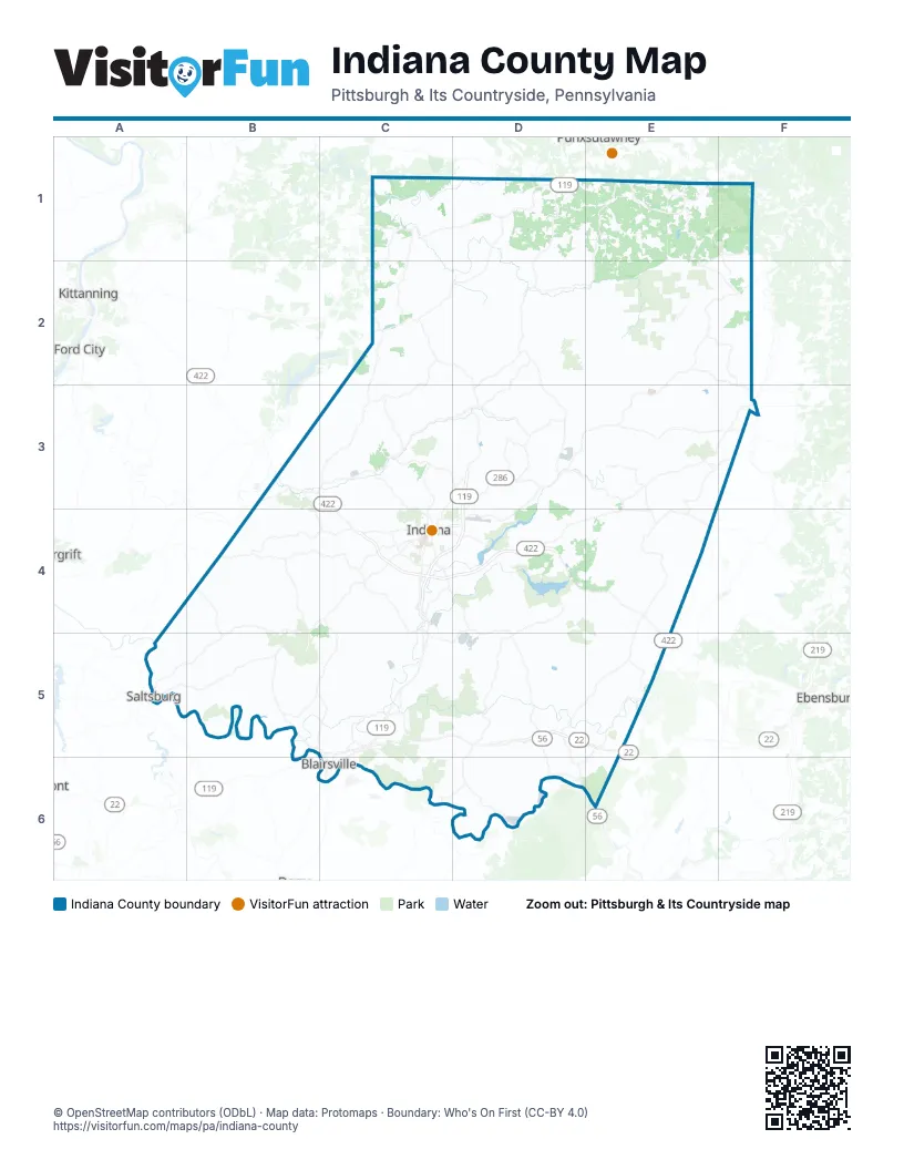
Maps inside Indiana County
2 maps inside, from the street map of Indiana County down.
Street index of Indiana County
Each street on the sheet and the grid squares it crosses.
- William Penn HighwayC5, D5, E5
- Buffalo-Pittsburgh HighwayD2, D3, C4
- Route 286 EastD3, D4
- Benjamin Franklin HighwayB3, C3, C4, E4
- Main StreetC2, D2, B3, C3, F3, C4, E4, A5, C5, E5
- Wayne AvenueC4
- Oakland AvenueC4, C5
- Philadelphia StreetC4
- Coal Run RoadB4
- Old William Penn HighwayC5, C6
- Washington StreetC4, A5, C6
- Old Route 119 Highway NorthC3, D3, C4
- West Pike RoadC4
- Walnut StreetC3, C4, E4, A5, C5, C6
- South Main StreetF3, C4, C5
- Franklin StreetD3
- Old Indiana RoadC5
- Leech AvenueA5
- South Walnut StreetC4, C6
- East Market StreetC6
- Ridge AvenueD2, C4, C5
- South 7th StreetC4
- North Walnut StreetD2, C4, C5, C6
- Market StreetF3, A5, C6
- Salt StreetA5
- North 4th StreetC4
- Indiana StreetC2, D5
- Buffalo Pittsburg HighwayC5
- West Burrell StreetC5, C6
- Ben Franklin HighwayE5
- Indiana HighwayC5
- South 9th StreetC4
- Patchin HighwayF3
- Five Points RoadC2, B3, C3
- Old Route 56 Highway WestB4, C4, C5
- Cramer PikeE4, D5, D6, E6
- Route 403 Highway NorthD2, D3
- Tipperary RoadE3, E4
- Chambersville RoadC3, D3
- Fulton Run RoadC3, C4
- Pearce Hollow RoadD2, D3
- South 6th StreetC4, D4
- Church StreetC2, D2, B4, C4, B5, C5, D5
- Rayne Church RoadD3
- Water StreetC2, D2, C3, C4, A5
- Indian Springs RoadC4
- 1st StreetC1, E1, B3, C3, D3, F3, C4, E4, A5, C5
- Barr Slope RoadD3
- Maple StreetC1, F2, F3, C4, E4
- Old US 119 Highway SouthC4, C5
- West Lebanon RoadB4
- Robinson StreetC5, C6, D6
- High StreetD2, F3, A5, C6
- 2nd StreetE1, B3, C3, D3, E3, C4, C5
- Front StreetF3, E4, C6, D6
- Penn StreetD3, F3, A5, D5, C6
- Old State Route 56 West HighwayB4
- Old Route 119 Highway SouthC4
- Shelocta StreetC3
- Indiana RoadC3
- Charles RoadD6
- Ben Franklin Road SouthC4
- North 9th StreetC4
- Mentcle RoadE4
- Hancock StreetD3
- Kittanning StreetC1
- North Main StreetF3, C4
- 6th StreetD3
- West Market StreetC6
- West Elm StreetC4
- East Wiley StreetC4
- State Route 3035C4
- Old Highway 119C4
- East Indiana StreetC2, C4
- Cherry StreetF3
- Smicksburg StreetC2
- Peg Run RoadF3
- Saltsburg RoadB4, A5, B5
- Newport RoadB5
- Tanoma RoadD3
- East Creek RoadD2, E2
- Parkwood RoadB4, C4
- Airport RoadD3, D4, B5
- Martin RoadD1, C3, C4, B5, D6
- Gipsy RoadE2
- Lochvale RoadE1, F1, F2
- Locust LaneE1, E2, C4
- Fire Tower RoadE1, F1, E2, D3, E3
- Juneau RoadD1, E1
- Wandin RoadE3
- Clay Pike RoadD5, D6
- Wehrum RoadE5
- Grisemore RoadE3, E4
- Arcadia RoadE2, F2, F3
- McIntyre RoadB4
- Warren RoadC4
- Cherry Tree RoadE2, F2, F3
- Hemlock Lake RoadE1, E2
- Johnsonburg RoadE1
- Campbells Mill RoadC5
- Iselin RoadB4, B5
- Mulligan Hill RoadD6
- Creekside RoadC3
- Barnard RoadC1, C2
- Rexis RoadE5
- East Pike RoadC4, D4
- Anthony Run RoadB3, B4, C4
- Grange RoadB5
- Glen Campbell RoadE2, F2
- Dayton Smicksburg RoadC1
- Lucerne RoadC4
- Palmerton RoadC5
- Steffey Church RoadE1
- Hillman RoadE1
- Cornell RoadC5
- Harry Boring RoadD5, D6
- Jessie Penrose RoadC5, C6, D6
- Stutzman RoadC4, E5, D6, E6
- Clyde RoadD5
- Pine Flats RoadE3, E4
- Penn View RoadC5
- Greenwich RoadE3, F3
- Buffalo Lodge RoadE1
- West Philadelphia StreetD5
- Bonner RoadE1
- Glenwood AvenueF2
- South 13th StreetC4
- Indiana AvenueA5, C5, C6
- Pine Ridge RoadC5
- Gas Center RoadE5
- McFeaters RoadD5
- 9th StreetC4, A5, D6
- Rose StreetC4, C5
- North 6th StreetC4
- Carter AvenueC4
- Hospital RoadC4
- East Philadelphia StreetD5
- Sunset StreetE1
- Central StreetE1
- Smyerstown RoadE1
- State Route 3022B4
- Valier DriveD1
- Point StreetA5, C5
- North Brady StreetC6
- Socialville LaneC5
- South R 3022B4
- Cathedral StreetA5
- Huff RoadD6
- Corporate Campus DriveC5
- State Route 3031B4
- Villa RoadC5
- Old Farm LaneC5
- Lucerne Road ExtensionC4
- Resort DriveC5
- State Route 1026C2
- Beverly LaneE5
- State Route 1022C1
- Stifflertown RoadF3
- Stiffler Hill RoadF3
- Pollock RoadE1, D2, E2
- Chestnut Ridge RoadD4, C5, C6
- Hill RoadC2, E3, B4, C5, D6
- Power Plant RoadC5, D6
- Camerons RoadD4, E4, D5, E5
- Smith RoadC1, D1, E1, C2, C4, C5
- Luciusboro RoadC5, D5
- Elders Ridge RoadA4, B4, A5
- Mahoning RoadC2, D2
- Clarksburg RoadB5
- Climax RoadC6, D6
- Hemlock RoadE3, F3, C4
- Park DriveB4, D4, B5, C5, D5
- Black Lick RoadC5
- Tunnelton RoadB5
- Groft RoadC2, D2, C3
- Laurel Run RoadD3, E3, E4
- Johnston RoadD2, C3
- Church RoadE1, E2, C3
- Purchase Line RoadD3, E3
- Pioneer Lake RoadE2, E3
- Richmond RoadD2, E2
- Skyline DriveD2, D3, C4, A5
- Craig RoadD2, C3, D3, B4
- Coal RoadC5, D5
- Alder RoadE3
- Allison RoadD3, E3, C4, D5
- Henry RoadD1, E1, E2, B4, C4, C5
- Marshall RoadD1, D2, B5
- Brown RoadE2, F2, C4, B5, C5
- Allen Bridge RoadD3, D4
- Starford RoadE3
- Redding Run RoadC2, C3
- Laurel RoadE3, C4, E4
- McCormick RoadC1, C2, D2, D5
- T860 - North Point DriveC1, D1
- Valley RoadE3, B4, C4, D5
- Ridge RoadE1, C2, D5, E5
- Sportsman RoadA4, B4, D4, E4, B5
- Pine Vale RoadE2
- Cookport RoadE3
- Bethel Church RoadD3, C4
- Julock RoadD2, E2
- Neal RoadD1, B4, C5
- Blackleggs RoadB4
- Dark Hollow RoadC3
- West Creek RoadD1, D2
- Willow RoadD3, B4
- Peles RoadE2, F2
- Spruce Grove RoadD4, E4
- Brady RoadD2, C4
- Spruce Hollow RoadD5
- Nashville RoadE2
- Snyder RoadE2, D4
- Deckers Point RoadD2, E2
- Hetzler RoadE2
- Nolo RoadE4
- Oneida Mine RoadD5
- Vanderbilt StreetE3
- Georgeville RoadD2
- Rayne Run RoadD2, D3
- Cribbs RoadC3, B4, B5
- Fleming RoadC3, D3, C4
- College Lodge RoadC3, C4, D4
- Chestnut StreetC1, C2, C4, E4, A5, C5, C6, D6, E6
- Johnson RoadD3, C4
- Braughler RoadE2, D3
- Pickering Run RoadD2, E2
- Rhine RoadC5, D5
- Dogwood RoadE3, C4
- Dixonville RoadD2, E2, D3
- Canoe Ridge RoadE1
- Cunkelman RoadB4, B5, C5
- Metz RoadC4, D4
- Grace Church RoadD3, D4
- Shellbark RoadD5
- Leasure Run RoadD1, D2, E2
- Rustic Lodge RoadC4
- Sebring RoadE2, E3
- Rossmoyne RoadC2, D2
- Griffith RoadC1, C2, E6
- Simons Rock RoadD4, E4
- Phillips RoadC1, D1, B4, B5
- Campground RoadD4, D5
- Cemetery RoadC2, D2, D3, B4, B5
- Dixon RoadD3, B5
- Kirkland RoadD3
- Wilgus RoadE2
- Yellow Creek RoadD4, E4
- McMillen RoadC2, D2
- Raspberry RoadE2, E3
- Barkley Church RoadE5
- Millstone RoadE2
- Spaulding RoadD3, E3, D4
- Beaver DriveD1
- Washington Church RoadC3, D3
- Miller RoadD1, C3
- Altimus RoadD5
- Clark RoadC2, F2, D4, C5, D5
- Smith StreetE2, E3
- Locust RoadD1, E1
- Hood School RoadD3, D4
- Thompson RoadD3, C5
- Nowrytown RoadA5
- Wells RoadE1, C2
- Coleman RoadB4, A5
- Rearick RoadB4
- Wright RoadD1, E1, E2
- Camp Faith RoadD4
- North Ridge RoadB3
- Cresswell RoadD4
- Hanging Rock RoadC3
- Musser RoadD3
- Goodville RoadC1
- Kohlhepp RoadD1, D2
- Morrow RoadC2
- East Run RoadE2
- Donahue RoadC3
- Mahan School RoadC5
- Mount Tabor RoadC5, D5
- Springfield RoadE4
- Dutch Run RoadB3, C3
- Grange Hall RoadD5, D6
- Mitchell Hill RoadE3, D6
- Stuchell RoadC3, D3, B4
- Fire Academy RoadC5, D5
- Spruce RoadE3, B4
- Pearce RoadF1, C2, F2
- Buterbaugh RoadE2
- Strangford RoadC5, C6
- Washington RoadD3, A5
- Kettering RoadC2, C3
- Claghorn RoadD5
- Goral RoadC4, C5
- Abel RoadE2, E3
- Sportsman Club RoadB3, B4
- Whiskey Run RoadB4
- Longs RoadD5
- Porterfield RoadE1, E2
- McConnel RoadB5
- North Ben Franklin RoadC3, C4
Things to do on the Indiana County map
Places on the map
- Armstrong Township
- Banks Township
- Black Lick
- Black Lick Township
- Blairsville
- Blue Spruce Park
- Brush Valley Township
- Buffington Township
- Burrell Township
- Canoe Township
- Center Township
- Charles F. Lewis Natural Area
- Cherry Tree
- Cherryhill Township
- Chevy Chase Heights
- Clymer
- Commodore
- Conemaugh River Lake
- Conemaugh Township
- Creekside
- Dixonville
- East Mahoning Township
- East Wheatfield Township
- Ernest
- Evergreen Landfill
- Glen Campbell
- Grant Township
- Green Township
- Heilwood
- Homer City
- Indiana
- Indiana Country Club
- Indiana County/Jimmy Stewart Field
- State Game Lands Number 153
- State Game Lands Number 174
- State Game Lands Number 262
- State Game Lands Number 273
- State Game Lands Number 276
- State Game Lands Number 332
- Yellow Creek State Park
Next to Indiana County
- Ebensburg
- Ford City
- Kittanning
- Punxsutawney
© OpenStreetMap contributors, Open Database License, openstreetmap.org/copyright · Map data: Protomaps · Boundary: Who's On First (CC-BY 4.0); Quattroshapes (CC BY 2.0)















