

Pennsylvania map
Scranton map
About 75,905 people live here (Census Bureau, 2024 estimate). The sheet's index lists 300 streets; North Scranton Expressway, American Legion Memorial Highway and North Main Avenue cross the most grid squares. Things to do inside the boundary: Steamtown National Historic Site.
Open the map (PDF, US Letter)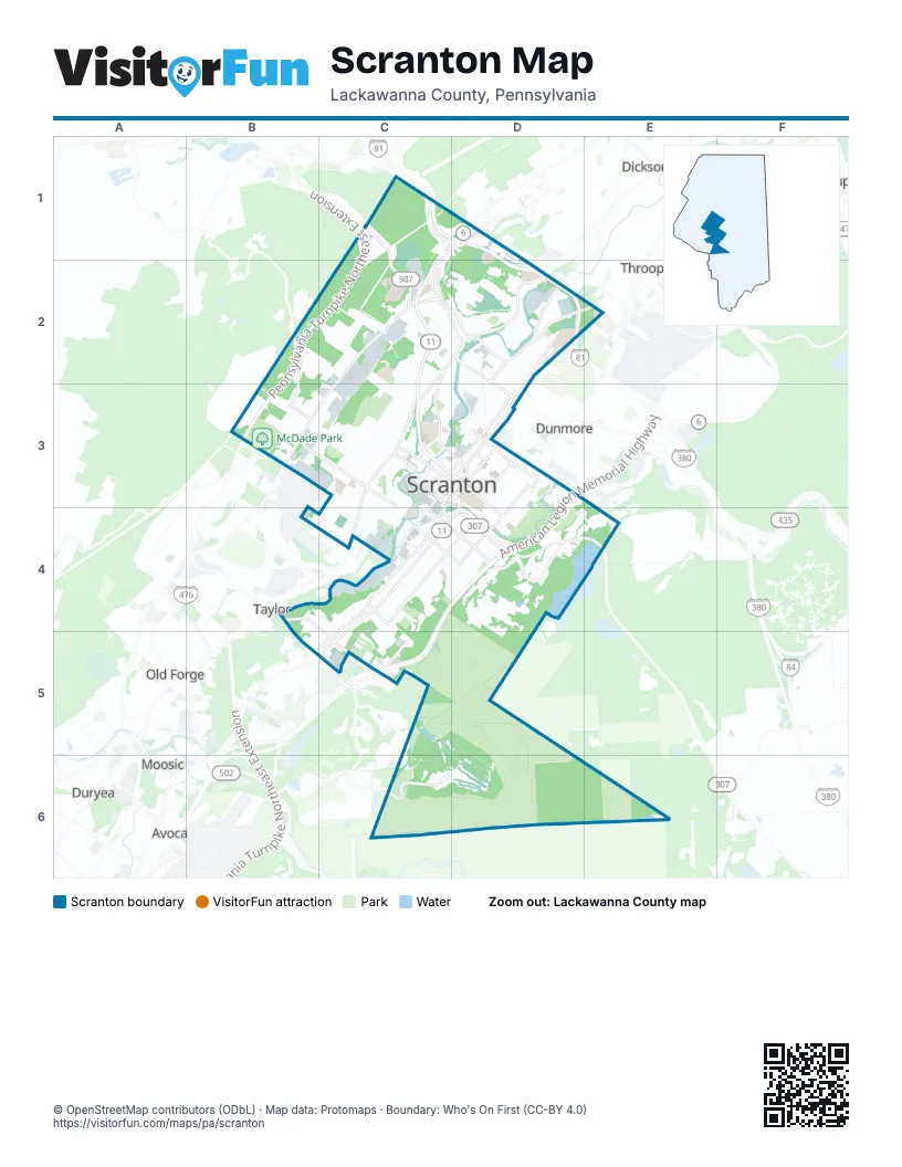
Street index of Scranton
Each street on the sheet and the grid squares it crosses.
- Pennsylvania Turnpike Northeast ExtensionC1, B2, C2, B3
- American Legion Memorial HighwayE4, D5, E5, C6, D6
- North Scranton ExpresswayD1, C2, D2, C3, C4, D4
- President Biden ExpresswayD4, D5
- Scranton Carbondale HighwayD1
- North Main AvenueD2, E2, C3, D3, C4
- Cedar AvenueD4, C5, D5, B6, C6
- North Keyser AvenueC2, D2, B3, C3
- Pittston AvenueD4, C5, D5, B6, C6
- North Washington AvenueE2, D3, E3, D4
- Moosic StreetD4, D5, E5
- Northern BoulevardD1
- Mulberry StreetD4, E4
- Birch StreetC4, D5
- Adams AvenueE2, D3, E3, D4
- Myrtle StreetD4, E4
- South Main AvenueC4, C5
- Davis StreetB5, B6, C6
- Birney AvenueC5, B6, C6
- Green Ridge StreetD2, D3
- Wheeler AvenueD4, E4
- Harrison AvenueD4, E4
- Jefferson AvenueD3, D4
- Lackawanna AvenueC4, D4
- South Keyser AvenueB3, B4
- Front StreetD4
- Main AvenueE2
- Sanders StreetC5
- Wyoming AvenueE2, D3, E3, D4
- West Market StreetD1, D2
- Providence RoadD3, C4, D4
- Penn AvenueD3, D4
- Morgan HighwayC1, C2
- River StreetC4, D4, D5
- Linden StreetC4, D4
- Crown AvenueD4, C5, D5, C6
- Clay AvenueD4
- North 7th AvenueC4
- West Olive StreetD3, D4
- West Lackawanna AvenueC4
- Biden StreetD4
- West Linden StreetC4
- South Webster AvenueD4, C5, D5, C6
- Stafford AvenueD5, C6
- Luzerne StreetB3, B4, C4
- Ash StreetD3, D4, E4
- Capouse AvenueE2, D3, D4
- East Elm StreetC4, C5, D5, D6, E6
- Jackson StreetB3, C3, C4
- Boulevard AvenueD2, E2, D3
- Cherry StreetC5, D5, D6
- South Washington AvenueC4, D4, C5
- Sanderson AvenueD2, D3
- East Gibson StreetD3, D4, E4
- Hickory StreetC4, D4, D5
- Oak StreetD1, D2
- East Mountain RoadD5, E5
- Newton RoadB2, B3
- Olyphant AvenueE2
- North Webster AvenueD4, E4
- Marion StreetD3
- Electric StreetD2, D3, E3
- Orchard StreetD4, D5
- Pear StreetC5, D5
- Seymour AvenueE5
- Charles StreetD2, E2
- East Market StreetD2, D3
- Duncan StreetC5, C6
- North 9th AvenueC4
- Viewmont DriveD1
- Ridge AvenueE4
- Bald Mountain RoadB4
- Mattes AvenueD4
- Dalton StreetB3, B4
- E.D. Preate DriveC6
- Saltry PlaceD1
- Hamm CourtD4, C5, D5, C6
- Kirst CourtD4, C5, D5, C6
- Prospect AvenueD4, C5, D5, C6
- North Sumner AvenueD2, C3, D3, C4
- Donnelly CourtD4, C5, D5
- Price StreetB3, C3, C4
- South Irving AvenueD4, C5, D5, C6
- Brook StreetC5, D5, D6
- Lafayette StreetB3, C3, C4
- Bergen CourtC4, D4, C5
- North Rebecca AvenueD2, C3, C4
- Grimes CourtD4, C5, D5, B6
- Washburn StreetB3, C4
- Gallagher CourtD4, C5, D5
- Vine StreetD4
- North Garfield AvenueC3, C4
- North South RoadC2, B3, C3
- Division StreetB3, C4
- Pine StreetD4, E4
- Alder StreetD4, D5
- Elmhurst BoulevardE4, E5
- Ferdinand StreetC2, D2
- Hertz CourtD4, C5, D5
- South Maple StreetC4, C5, D5
- Beech StreetC4, C5, D5
- Prescott AvenueD4, E4
- West Elm StreetC4
- Willow StreetC4, D5
- Schmidt CourtD4, D5
- Rosen CourtD4, C5, D5
- East Locust StreetE4, C5, D5
- West Locust StreetB4, C4
- Boland CourtD5
- Madison AvenueD4
- Taylor AvenueD4, E4
- Olive StreetD4, E4
- North Irving AvenueD4, E4
- Rockwell AvenueD1, D2
- Kane StreetC5, C6
- Schimpf CourtC4, D4, C5, B6
- Fig StreetC5, D5, D6
- Hitchcock CourtD4
- Quincy AvenueD4
- Court StreetC3, D3
- Palm StreetC5, D5
- Monroe AvenueD4
- Buenzli CourtD4, E4
- Farber CourtD4, E4
- Moltke AvenueD5
- North Hyde Park AvenueC3, C4
- North Bromley AvenueC3, C4
- North Lincoln AvenueC3, C4
- Smallacombre DriveC2
- Fellows StreetB4, C4
- Roberts CourtD2, C3, D3, C4
- Crossin CourtD2, C3, D3
- Swetland StreetB3, C3
- Kressler CourtD4
- Lauvelle CourtD4, C5, D5
- McGuinness CourtD4, D5
- Meadow AvenueD5
- McKenna CourtD4
- Geraldine CourtD2, C3, D3
- Ridge RowD4
- Eynon StreetC4
- Euclid AvenueC2, D2, C3
- Kellum CourtD4
- Stipp CourtD4, E4
- Preston PlaceB4, C4
- Morgan CourtD4, D5
- Clearview StreetC2, D2, D3
- Round Woods PlaceB4, C4
- Parkhurst PlaceC3
- Hampton StreetC4
- Regan PlaceC4
- Albright AvenueD3
- Max CourtD5
- Saginaw StreetC5, C6
- Lavelle CourtC5
- Farr StreetC3
- Apgar PlaceC4
- Hemlock StreetD4, D5
- Theodore StreetC2, D2
- Woodlawn StreetD2, E2, E3
- Brick AvenueD2
- Summit PointeD1
- Meridian AvenueC4
- Forest Glen DriveB3
- Schultz CourtD4, E4
- Manila PlaceC3
- Colliery AvenueC5, B6, C6
- Rundle StreetB4, C5
- South 6th AvenueC4, C5
- Herz CourtD4, C5
- Colfax AvenueD4, E4
- Dorothy StreetC3
- Monsey AvenueD3
- South 9th AvenueC4
- Moir CourtD4
- Frink StreetB3
- Gibbons StreetC5, C6
- Parallel DriveB2, B3
- Sherwood CourtD4, E4
- Smith PlaceD2, B4, C4, C5
- South Keastner CourtD5
- Parrott AvenueB4, C4
- Wintermantle AvenueD5
- Wayne AvenueD2
- Ridgeview DriveB2, B3
- Costello CourtD4
- Forest CourtD4
- Pettibone StreetC3
- Mahon CourtD4
- Pike StreetD1, C2
- Murphy CourtC5, B6, C6
- Sloan StreetB4, C4, C5
- Watson StreetB4, C5
- Church AvenueD2, D3
- Albert PlaceB4, C5
- Mary StreetD2
- Winfield AvenueC5, C6
- Laurel Line DriveD4
- Nay Aug AvenueD2, D3
- Philo StreetC2, C3, D3
- Oakford CourtD3, D4
- Poplar StreetD3, D4, E4
- North Everett AvenueC3
- Breck StreetC5
- Oliver PlaceB4, C4
- Delaware StreetD3, E3
- Diamond AvenueD3
- Garrett PlaceB4, C5
- Dickson AvenueD2, D3
- Cliff StreetC4
- Wood StreetC2, D2, D3
- Lake Mountain RoadD5, E5
- Arthur AvenueD4, E4, D5
- Von Storch AvenueD2, D3
- Froude Street AvenueD5, D6
- Hollister AvenueD2
- Putnam StreetD2
- North Decker CourtC3, D3, C4
- East Parker StreetD2, E2
- Campbell StreetC5, C6
- Lucky Run RoadA3, B3
- Hand PlaceC4
- 12th AvenueC4
- Saint Ann StreetC4
- Wilbur StreetD2
- Reese StreetD2
- North Cameron AvenueB3, C3
- Greenbush StreetD1, D2
- Bryn Mawr StreetC4
- West Parker StreetD2
- Genet StreetC5
- Pancoast StreetE2
- Coyle PlaceD4, D5
- Amelia AvenueD2, E2
- Mifflin AvenueC4, D4
- North Filmore AvenueC3, C4
- Larch StreetD3
- New York StreetD3
- White Birch DriveC2
- 10th AvenueC4
- South Hyde Park AvenueC4
- Dartmouth StreetC4
- Leggett StreetD2
- Crane StreetB5, B6
- Lyford PlaceC4
- Railroad AvenueC4
- Wales StreetD2
- Meylert AvenueD2, D3
- Foster StreetC3, D3
- Edwards CourtC4
- Valley View TerraceD5
- Franklin AvenueD4
- Pen-Y-Bryn DriveE4, E5
- Richmont StreetD2, D3, E3
- South Sekol AvenueB3
- Woods PlaceB4, C4
- Amherst StreetB4, C4
- Dupont CourtD3, D4
- Lake Scranton RoadE4, E5
- 4th AvenueC4
- Waldorf LaneD5, E5
- Log RoadD5
- Neptune PlaceC4, D5
- Academy StreetC4
- O'Hara StreetC5
- Grandview StreetD2, E2, E3
- 3rd AvenueC4
- Rosar PlaceD4, D5
- North St Frances Cabrini AvenueC3, C4
- Oakwood DriveC2
- Wells StreetD2, E2
- Cornell StreetB4, C4
- Dexter AvenueB3
- Spring StreetD2
- Whitetail DriveB2, B3
- Southwest Morgan CourtC5, D5
- Walnut StreetD3
- Townhouse BoulevardC3, D3
- Powderly CourtC3
- Koch PlaceC4, D4, D5
- West Gibson StreetC3
- School StreetD2
- Evans PlaceB4, C4
- Ripple StreetC5
- Hollow AvenueD1
- Oram StreetC3
- Crisp AvenueB3
- Durkin AvenueD2
- South Sherman AvenueB3, B4
- Mc Donough StreetB5, B6, C6
- Conroy StreetE5
- Columbia StreetD3, E3
- Nay Aug RoadD4, E4, D5, E5
- Florida AvenueE5
- Matthew AvenueE4, D5, C6
- Snyder AvenueC4, C5
- Herbert StreetC5, C6
- Schlager StreetC3
- Snook StreetE5
- Drinker PlaceD3, E3
Things to do on the Scranton map
Places on the map
- Allied Services Scranton Rehab Hospital
- Armed Forces Reserve Center
- Baby Bell
- Boomer
- Cannonball
- Cathedral Cemetery
- Cliff Street
- Clover Field
- Connection
- Connell Park
- Connell Park Little League
- Downtown Scranton Post Office
- East Scranton Field
- Fawnwood Golf Complex
- Gino J. Merli Veterans Center
- Green Ridge Plaza
- Heritage Trail
- Highball
- Johnson College
- Keyser Oak Shopping Center
- Lackawanna County Prison
- Lower Fast Track
- Lower Runaway
- Mainline
- McDade Park
- Montage Mountain Ski Area
- NEPA Auto Auction
- Pa-5 Reservoir
- Scranton High School
- Smoke
- Spike
- Steamtown National Historic Site
- Switch
- The Marketplace at Steamtown
- University of Scranton
- Upper Fast Track
- Upper Runaway
- Viewmont Mall
- Whistler
- White Lightning
Next to Scranton
- Dunmore map
- Old Forge
- Taylor
- Throop
© OpenStreetMap contributors, Open Database License, openstreetmap.org/copyright · Map data: Protomaps · Boundary: Who's On First (CC-BY 4.0); U.S. Census Bureau















