

Rhode Island map
Central Falls map
About 23,034 people live here (Census Bureau, 2024 estimate). The sheet's index lists 128 streets; High Street, Broad Street and Lonsdale Avenue cross the most grid squares. Also on it: Valley Falls Pond, Central Falls City Hall and Central Falls Post Office.
Open the map (PDF, US Letter)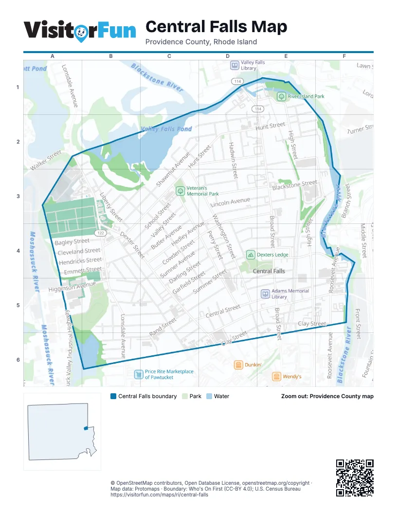
Street index of Central Falls
Each street on the sheet and the grid squares it crosses.
- Broad StreetD1, E1, E2, E3, E4, E5, E6
- High StreetD1, E1, E2, F2, E3, F3, E4, E5
- Madeira AvenueD1, D2
- Crown StreetE1, E2
- Division StreetE1
- River StreetE1
- Samoset AvenueE1, E2
- Althea AvenueA2
- Lonsdale AvenueA2, A3, B3, B4, B5, B6
- Richland AvenueA2, B2
- Walker StreetA2
- Arrow StreetC2, C3
- Cottage StreetC2, D2, E2
- Hooker StreetC2
- Hunt StreetC2, D2, E2, B3, C3, B4
- Jenks AvenueC2, D2, E2
- Lake StreetC2
- Notre Dame StreetC2, D2
- Shawmut AvenueC2, B3, C3
- Temple PlaceC2
- Washington StreetC2, C3, D3, D4, D5
- Eben Brown LaneD2
- Hadwin StreetD2, D3
- Hawley StreetD2
- Lewis StreetD2
- Martins WayD2
- Tremont StreetD2, E2, C3, D3
- Verdun StreetD2
- Chace's LaneE2
- Courtland StreetE2, F2
- New Haven AvenueE2, F2
- Binford StreetA3, B3
- Conduit StreetA3
- Dutchess WayA3
- Tucker StreetA3, B3
- Aetna StreetB3, C3
- Belmont StreetB3, C3
- Cliff StreetB3
- Dexter StreetB3, B4, C4, C5, D5, D6
- Echo StreetB3
- Liberty StreetB3, B4
- Phoenix StreetB3
- Worth StreetB3
- Butler AvenueC3, C4
- Fuller AvenueC3, C4, D5
- Illinois StreetC3, C4, D4, D5
- Perry StreetC3, D3, D4
- Reed AvenueC3
- Richmond StreetC3
- School StreetC3, B4, C4
- Valley StreetC3, B4, C4
- Acorn StreetD3
- Chestnut StreetD3, E3
- Cowden StreetD3, E3, C4, D4
- Fletcher StreetD3, D4
- Hedley AvenueD3, C4
- Henry StreetD3
- Hood StreetD3
- Lincoln AvenueD3, E3
- Sylvian StreetD3, E3
- Bellevue AvenueE3
- Blackstone StreetE3, F3
- Sheridan StreetE3, E4
- Walnut StreetE3
- Bagley StreetA4, B4
- Cleveland StreetA4, B4
- Emmett StreetA4, B4
- Hendricks StreetA4, B4
- Wetmore StreetA4
- Crossman StreetB4
- Earle StreetB4, C4, C5
- Pine StreetB4, B5, C5, C6
- Prime StreetB4
- Tiffany StreetB4, B5
- West Hunt StreetB4
- Darling StreetC4, D4, C5
- Garfield StreetC4, D4, C5
- Moore StreetC4, B5, C5
- Sumner AvenueC4, D4, C5
- Beacon StreetD4
- Fales StreetD4, E4
- Foundry StreetD4, E4
- King StreetD4
- Ledge StreetD4, E4
- Phillips StreetD4
- Summer StreetD4, C5, D5
- Charles StreetE4, F4
- Eastwood StreetE4
- George StreetE4
- Railroad StreetE4, E5
- Sacred Heart AvenueE4
- Summit StreetE4, D5
- Roosevelt AvenueF4, F5
- Higginson AvenueA5, B5
- Brook StreetB5
- Claremont StreetB5
- Garvey CourtB5, B6
- Kendall StreetB5, C5
- Oakland StreetB5
- Orchard StreetB5, B6
- Park StreetB5
- Parker StreetB5, C5
- Watson StreetB5, C5
- Central StreetC5, D5, E5, F5, C6
- Chapel StreetC5
- Mowry StreetC5
- Rand StreetC5, D5, B6, C6
- Richardson StreetC5
- Clay StreetD5, E5, F5, D6
- Clinton StreetD5
- Cross StreetD5, E5, F5, C6, D6
- Evaleen StreetD5
- Hawes StreetD5, E6
- Hollie StreetD5
- Knight StreetD5, C6
- Madison AvenueD5
- Mary StreetD5
- Pacific StreetD5, E5
- Elm StreetE5
- Jenks StreetE5
- Montgomery StreetE5
- Central AvenueF5
- Ayr StreetB6
- Barber AvenueB6
- Clifton StreetB6
- Cherry StreetD6
- Congress StreetD6
- Olive StreetD6
Places on the map
- Adams Memorial Library
- Assembly of God Church
- Aura of Rhode Island
- Bible Baptist Church
- Boston Switch
- Breakfast
- Captain G Harold Hunt School
- Casade Oracion Gethsemane Church
- Central Falls City Hall
- Central Falls Congregational Church
- Central Falls Fire Department
- Central Falls Police Department
- Central Falls Post Office
- Central Street School
- Coutu Memorial Park
- Cowden Street School
- Dexters Ledge
- Doctor Earl F Calcutt Middle School
- Donald W. Wyatt Detention Center
- Dunkin'
- El Gallo De Oro
- Ella Risk School
- Fallon Memorial School
- Family Dollar
- Holy Spirit Catholic Church
- Holy Trinity Church Complex
- Hunt School
- Jenks Park
- Louis C. Yip Soccer Field
- Macomber Stadium
- Margaret I Robertson School
- Moshassuck Cemetery
- Play Plus Preschool
- River Island Campground
- River Island Park
- Saint Ephraims Church
- Saint Joseph Catholic Church
- Spurwick School II
- Valley Falls Pond
- Veteran's Memorial Park
© OpenStreetMap contributors, Open Database License, openstreetmap.org/copyright · Map data: Protomaps · Boundary: Who's On First (CC-BY 4.0); U.S. Census Bureau















