

Rhode Island map
Providence County map
About 675,912 people live here (Census Bureau, 2024 estimate). The sheet's index lists 298 streets; Main Street, Victory Highway and South Main Street cross the most grid squares. Things to do inside the boundary: Bally's Lincoln Casino Resort, Benefit Street and Federal Hill.
Open the map (PDF, US Letter)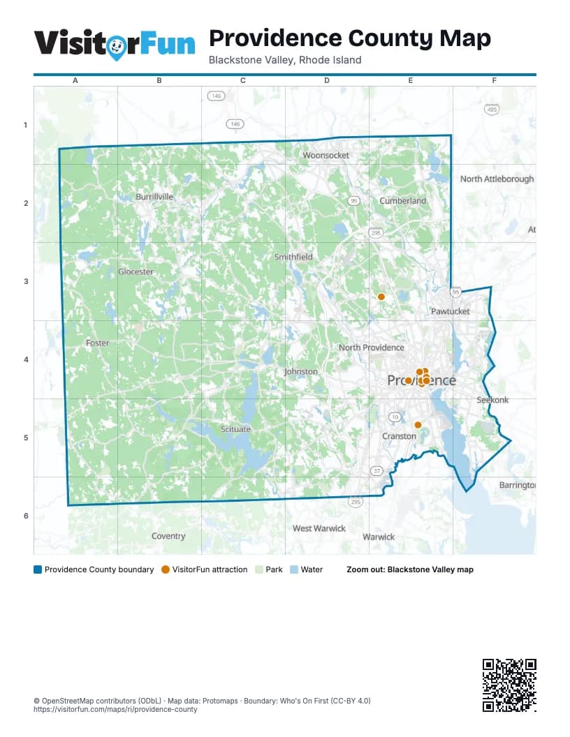
Street index of Providence County
Each street on the sheet and the grid squares it crosses.
- Wallum Lake RoadA1, A2, B2
- Round Top RoadB1, B2
- Sherman Farm RoadB1, B2
- Central StreetC1, E3
- Greene StreetC1, D1
- North Main StreetC1, E4
- North Smithfield ExpresswayC1, D1, D2
- Providence PikeC1, C2, D2, A5
- Quaker HighwayC1
- Victory HighwayC1, D1, C2, B3, B6
- Arnold StreetD1
- Bernon StreetD1
- Clinton StreetD1
- Court StreetD1
- Cumberland Hill RoadD1, D2
- Cumberland StreetD1
- Diamond Hill RoadD1, E1, E2, E3
- Great RoadD1, D2, E3
- Hamlet AvenueD1
- Harris AvenueD1, E4
- High StreetD1, E3
- Main StreetD1, B2, E3, F3, E4, C6, D6
- Manville RoadD1, D2
- Mendon RoadD1, D2, E2, E3
- Park AvenueD1, D2, E5
- Privilege StreetD1
- Providence StreetD1, D2
- Railroad StreetD1
- Rathbun StreetD1
- Saint Paul StreetD1
- Social StreetD1
- South Main StreetD1, B2, D2, B3, E4
- Truman DriveD1
- Winter StreetD1
- Worrall StreetD1
- Cumberland RoadE1
- Pine Swamp RoadE1
- Wrentham RoadE1
- Bridge WayB2
- Broncos HighwayB2, C2, B3
- Callahan School StreetB2
- Chapel StreetB2
- Church StreetB2, E3
- East AvenueB2, C2, E3, E4
- Harrisville Main StreetB2
- Pascoag Main StreetB2
- Sayles AvenueB2
- Steere Farm RoadB2, B3
- Douglas TurnpikeC2, D2
- Greenville RoadC2, D2
- Albion RoadD2, D3
- Branch PikeD2, D3
- Douglas PikeD2, D3, E3
- Eddie Dowling HighwayD2, E2, E3
- Farnum PikeD2, D3
- George Washington HighwayD2, E2, D3
- Main Street ManvilleD2
- Manville Hill RoadD2, E2
- Old River RoadD2, E2, E3
- Sayles Hill RoadD2
- Smithfield RoadD2, E4
- Woonsocket Industrial HighwayD2
- Angell RoadE2
- Anna Sayles RoadE2
- Nate Whipple HighwayE2
- Putnam PikeA3, B3, C3, D3, D4
- Reynolds RoadA3, A4
- Chopmist Hill RoadB3, B4, B5
- Money Hill RoadB3
- Cedar Swamp RoadD3, D4
- Esmond StreetD3, D4
- Jenckes Hill RoadD3, E3
- Pleasant View AvenueD3, D4
- Twin River RoadD3, E3
- Waterman AvenueD3, D4, F4, F5
- Ann and Hope WayE3
- Barton StreetE3, E4
- Blackstone StreetE3
- Breakneck Hill RoadE3
- Broad StreetE3, E4, E5
- BroadwayE3, F3, E4, F4
- Central AvenueE3, F3, D4, E4, D5
- Chambers StreetE3
- Charles StreetE3, E4
- Comstock StreetE3, E4
- Cross StreetE3
- Dexter StreetE3
- Division StreetE3, F3
- Douglas AvenueE3, E4
- East StreetE3, F3, E6
- Exchange StreetE3, F3, E4
- Front StreetE3
- Garden StreetE3, E4
- George StreetE3, E4
- Goff AvenueE3
- Grace StreetE3
- Highland AvenueE3, F5
- Hunt StreetE3
- Jenks WayE3
- John StreetE3, F4
- Lonsdale AvenueE3, E4
- Marrin StreetE3
- Marshall AvenueE3
- Mineral Spring AvenueE3, D4, E4
- Old Louisquisset PikeE3, E4
- Park PlaceE3
- Pearl StreetE3
- Pine StreetE3, E4
- Pleasant StreetE3, F4
- Power RoadE3, E4
- Prospect StreetE3, F4
- River RoadE3
- Roosevelt AvenueE3
- School StreetE3, E4, F4
- Smithfield AvenueE3, E4
- Summer StreetE3
- Vernon StreetE3, F3
- Walcott StreetE3, F3
- Walker StreetE3
- Water StreetE3, E4
- Weeden StreetE3
- West Hunt StreetE3
- Armistice BoulevardF3
- Cottage StreetF3
- Denver StreetF3
- George Bennett HighwayF3, F4
- Grove StreetF3
- Newport AvenueF3, F4
- Spring StreetF3
- Summit StreetF3
- Underwood StreetF3
- US 1F3
- Grand Army HighwayA4, B4, C4, A5
- Hartford PikeA4, B4, C4
- Mount Hygeia RoadA4, B4
- Sheldon RoadA4
- Danielson PikeB4, C4
- Foster Center RoadB4, B5
- East RoadC4, C5
- Hartford AvenueC4, D4, E4
- Smith AvenueC4, D4
- West Greenville RoadC4
- Atwood AvenueD4, D5, E5
- Centerdale BypassD4
- Cherry Hill RoadD4
- Dennis J. Roberts ExpresswayD4, E4
- George Waterman RoadD4
- Greenville AvenueD4
- I 295D4, D5
- Killingly StreetD4, E4
- Manton AvenueD4, E4
- Sanderson RoadD4
- Smith StreetD4, E4
- 6/10 ConnectorE4
- Admiral StreetE4
- Allens AvenueE4, E5
- Angell StreetE4
- Ashburton StreetE4
- Atwells AvenueE4
- Blackstone BoulevardE4
- Branch AvenueE4
- Butler AvenueE4
- Canal StreetE4
- Chalkstone AvenueE4
- Clifford StreetE4
- Cranston StreetE4, E5
- Dean StreetE4
- Dorrance StreetE4
- Doyle AvenueE4
- Duxbury StreetE4
- Dyer StreetE4
- East Franklin StreetE4
- East Providence ExpresswayE4, F4, F5
- Eddy StreetE4, E5
- Elmwood AvenueE4, E5
- Empire StreetE4
- Evans ParkE4
- Exchange TerraceE4
- Fountain StreetE4
- Francis StreetE4
- Franklin StreetE4
- Fruit Hill AvenueE4
- Gano StreetE4
- Gaspee StreetE4
- Glenbridge AvenueE4
- Grand Army of the Republic HighwayE4
- Hayes StreetE4
- Henderson ParkwayE4, F4
- High Service AvenueE4
- Hope StreetE4
- Huntington ExpresswayE4, E5
- IwayE4
- John J. Partington WayE4
- Kinsley AvenueE4
- Memorial BoulevardE4
- Messer StreetE4, E5
- Mill StreetE4
- Mount Pleasant AvenueE4
- Oakland AvenueE4
- OldLouisquisset PikeE4
- Olney StreetE4
- Olneyville SquareE4
- Orms StreetE4
- Park StreetE4
- Pawtucket AvenueE4, F4, F5
- Pike StreetE4
- Plain StreetE4
- Plainfield StreetE4, D5, E5
- Pleasant Valley ParkwayE4
- Pocasset AvenueE4, E5
- Point StreetE4
- Promenade StreetE4
- Providence PlaceE4
- Randall StreetE4
- Raymond StreetE4
- Sabin StreetE4
- Service RoadE4
- Silver Spring StreetE4
- South Angell StreetE4
- South Water StreetE4
- Steeple StreetE4
- Sunset AvenueE4
- Taunton AvenueE4, F4
- Thomas StreetE4
- Thurston StreetE4
- Tobey StreetE4
- Union AvenueE4, E5
- Valley StreetE4
- Veterans Memorial ParkwayE4, E5, F5
- Warren AvenueE4, F4, F5
- Washington PlaceE4
- Washington StreetE4
- Waterfront DriveE4, F4
- Waterman StreetE4
- Westminster StreetE4
- Weybosset StreetE4
- Wickenden StreetE4
- Woonasquatucket AvenueE4
- Beverage Hill AvenueF4
- Centre StreetF4
- East Shore ExpresswayF4, F5
- Fall River AvenueF4
- Freeborn AvenueF4
- Hall StreetF4
- Massasoit AvenueF4
- Newman AvenueF4
- North BroadwayF4
- Roger Williams AvenueF4, E5
- South BroadwayF4, F5
- South County StreetF4
- Plainfield PikeB5, C5, D5, B6
- Rockland RoadB5
- Tunk Hill RoadB5, C5, C6
- North RoadC5, C6
- Scituate AvenueC5, D5, C6
- Comstock ParkwayD5
- Dean ParkwayD5, E5
- Green Hill RoadD5
- Natick AvenueD5
- Oaklawn AvenueD5, E5, D6
- Phenix AvenueD5, E5, D6
- Sailor WayD5
- Shun PikeD5
- Wayland AvenueD5
- Wilbur AvenueD5, D6
- Budlong RoadE5
- Carter StreetE5
- Dyer AvenueE5
- Gansett AvenueE5
- Greenwich StreetE5
- Haven AvenueE5
- Huntington AvenueE5
- I 95E5
- Narragansett BoulevardE5
- Narragansett ParkwayE5
- New London AvenueE5, D6, E6
- Norwood AvenueE5
- Pontiac AvenueE5, E6
- Public StreetE5
- Reservoir AvenueE5
- Rolfe SquareE5
- Service Road 1E5
- Thurbers AvenueE5
- Vermont AvenueE5
- Warwick AvenueE5
- Bullocks Point AvenueF5
- County StreetF5
- Crescent View AvenueF5
- Mink RoadF5
- Mink StreetF5
- Park DriveF5
- Wampanoag TrailF5
- Willett AvenueF5
- Knotty Oak RoadC6
- Bald Hill RoadD6
- Jackson Flat RoadD6
- Lambert Lind HighwayD6
- Mayfield AvenueD6, E6
Things to do on the Providence County map
Places on the map
- Agawam Hunt
- Aldrich-Marshall Woods
- Allendale Mill Pond
- Almy Reservoir
- Alpine Country Club
- Alpine Estates
- Arnold Mills Reservoir
- Ash Swamp
- Aust Family Preserve at Lime Rock
- Baffoni's Poultry Farm
- Barden Reservoir
- Barney Pond
- Beauregard Loop
- Betty Pond
- Big Round Top Pond
- Black Hut State Management Area
- Blackall Family and Ballou Farm Preserve
- Blackamore Pond
- Blackstone Boulevard Park
- Blackstone Gorge
- Blackstone Park
- Blackstone River
- Blackstone River Valley National Historical Park
- Blanchard Memorial Management Area
- Bleachery Pond
- Blue Trail
- Booth Pond
- Borders Farm
- Bowdish Reservoir
- Bradley Hospital
- Brown University
- Brush Meadow Swamp
- Bryant University
- Buck Hill Management Area
- Buck Hill Pond
- Buck Hill Scout Reservation
- Burlingame Reservoir
- Burrillville
- Burrillville High School
- Burrillville Middle School
Next to Providence County
- Barrington
- Blackstone
- Coventry
- North Attleborough
- Seekonk
- Warwick
- West Warwick
© OpenStreetMap contributors (ODbL) · Map data: Protomaps · Boundary: Who's On First (CC-BY 4.0)