

Rhode Island map
Blackstone Valley map
The sheet's index lists 30 highways; US 6, I-295 and US 44 cross the most grid squares. Things to do inside the boundary: Bally's Lincoln Casino Resort, Benefit Street and Cape Verdean Museum. Also on it: Ashton, Burrillville and Chepachet.
Open the map (PDF, US Letter)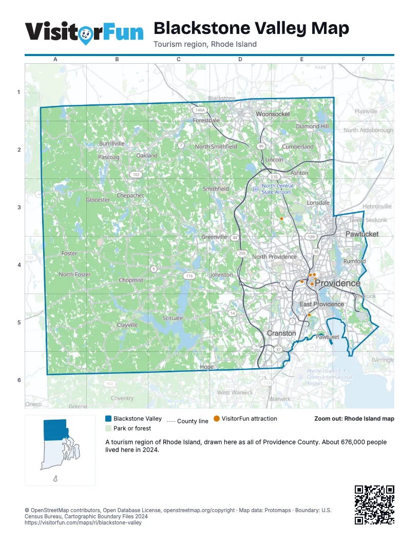
Highway index of Blackstone Valley
Each highway on the sheet and the grid squares it crosses.
- I-95E3, E4, E5, F3
- I-195E4, F4, F5
- I-295D2, D3, D4, D5, D6, E2, F2
- US 1E3, E4, E5, F3
- US 1AE4, E5, F3, F4, F5
- US 6A4, A5, B4, C4, D4, E4, F4, F5
- US 44A3, B3, C3, D3, D4, E4, F4
- RI 2D6, E5, E6
- RI 5C2, D2, D3, D4, D5, D6, E5
- RI 7C2, D2, D3, E3, E4
- RI 10E4, E5
- RI 12D5, E5
- RI 14B5, B6, C5, D5
- RI 15D4, E3, E4, F3
- RI 37D5, E5, E6
- RI 99D2
- RI 101A4, B4, C4
- RI 102B2, B3, B4, B5, B6, C1, C2
- RI 103F5
- RI 104C2, D2, D3
- RI 114D1, E1, E2, E3, F3, F4, F5
- RI 116C4, C5, C6, D2, D3, D4, E2
- RI 117E5
- RI 121E1
- RI 122D1, D2, E2, E3, E4
- RI 123E3
- RI 126D1, E3, E4
- RI 146C1, D1, D2, E2, E3, E4
- RI 146AC1, D2
- RI 246E4
Things to do on the Blackstone Valley map
- Bally's Lincoln Casino Resort
- Benefit Street
- Cape Verdean Museum
- Federal Hill
- Lincoln Woods State Park
- Providence Performing Arts Center
- Providence Place
- Rhode Island State House
- RISD Museum
- Roger Williams National Memorial
- Roger Williams Park Zoo
- Slater Mill Historic Site
- Slavery Memorial (Brown University)
- The Museum at the John Brown House
- Waterplace Park
- World War II Veterans Memorial State Park
Places on the map
- Ashton
- Burrillville
- Chepachet
- Chopmist
- Clayville
- Cranston
- Cumberland
- Diamond Hill
- East Providence
- Forestdale
- Foster
- Glocester
- Greenville
- Hope
- Johnston
- Lincoln
- Lonsdale
- North Foster
- North Providence
- North Smithfield
- Oakland
- Pascoag
- Pawtucket
- Pawtuxet
- Providence
- Rumford
- Scituate
- Smithfield
- Woonsocket
Next to Blackstone Valley
- Eastern Connecticut
- Central Massachusetts
- Greater Boston
- South of Boston
- Newport and Bristol Counties map
- Warwick & West Bay map
© OpenStreetMap contributors, Open Database License, openstreetmap.org/copyright · Map data: Protomaps · Boundary: U.S. Census Bureau, Cartographic Boundary Files 2024