

Rhode Island map
Middletown map
About 16,610 people live here (Census Bureau, 2024 estimate). The sheet's index lists 300 streets; Aquidneck Avenue, Green End Avenue and Burma Road cross the most grid squares. Also on it: Aquidneck Corporate Park, Gardiner Pond and Green End Pond.
Open the map (PDF, US Letter)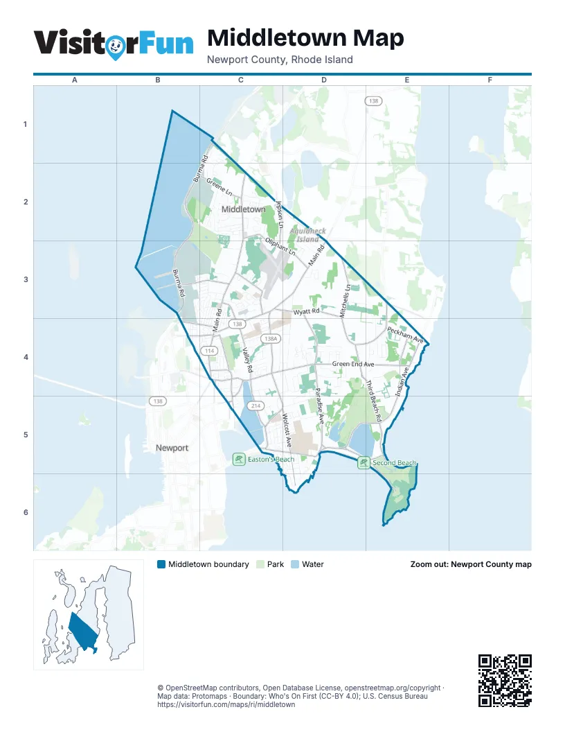
Street index of Middletown
Each street on the sheet and the grid squares it crosses.
- West Main RoadC2, C3, C4
- Aquidneck AvenueC3, C4, C5, D5
- East Main RoadC3, D3, C4
- Purgatory RoadC5, D5
- Coddington HighwayB4, C4
- BroadwayC4
- Green End AvenueC4, D4, E4, C5
- Valley RoadC3, C4, C5
- Miantonomi AvenueC4
- Admiral Kalbfus RoadC4
- Burma RoadC1, B2, C2, B3
- Third Beach RoadD4, E4, E5
- Mitchells LaneD3, D4
- Indian AvenueE4, E5
- Paradise AvenueD4, D5
- Hanging Rock RoadD5, E5
- Wolcott AvenueC5, D5, D6
- Oliphant LaneC2, C3, D3
- Wyatt RoadC3, D3
- Sachuest Point RoadD5, E5, E6
- Wapping RoadE3, D4, E4
- Forest AvenueC3
- Berkeley AvenueD3, D4
- Gate 17 Access RoadB3, C3
- Greene LaneB2, C2
- BoulevardC4, C5
- Vaucluse AvenueE4
- Jepson LaneC2, C3
- Peckham AvenueE4
- High StreetC4
- Maple AvenueB4, C4
- Bliss Mine RoadC5
- Kay BoulevardC5
- Bliss RoadC5
- Commercial StreetC4
- Freeborn StreetC4
- Old Mill LaneE3
- Tuckerman AvenueC5, D5, D6
- Turner RoadD3, D4
- Cunningham StreetB3, C3
- Browns LaneB2, C2, C3
- Reservoir RoadC5, D5
- Simonpietri DriveB3, B4
- Compton View DriveD4
- Lay StreetB3
- Meadow LaneD3
- Chases LaneB3, C3
- Island DriveD2, D3
- Kane AvenueD5, D6
- Bayview ParkB4
- Prospect AvenueD5
- Allston AvenueC5, D5
- Jones StreetB3, C3, C4
- Honeyman AvenueC4
- Sachuest WayD4
- Bushnell StreetB3
- John Clarke RoadC4, C5
- Lexington StreetC3, C4
- Puritan DriveC1, C2
- Continental DriveC4
- Trout DriveD4
- Squantum DriveC2
- Gossets Turn DriveC2
- Morrison AvenueC4, D4
- Bailey AvenueD4
- Corey LaneD4
- J H Dwyer DriveC2
- Rogers LaneC2
- Vernon AvenueC4
- Wyndham Hill RoadD4
- Campus DriveD5
- Admiralty DriveB3, C3
- River RunD4, D5
- Circle DriveD2, D3
- Revolution WayC1
- Pasture Farm DriveC2
- Center AvenueD5
- Connecticut AvenueC4
- Bay Ridge DriveC3
- Howland AvenueE4
- Bartlett RoadE4
- Lawrence StreetC3, C4
- Newport AvenueC5, D5
- Coggeshall WayD3
- John Kesson LaneC2
- Seascape AvenueC5, D5
- South DriveD3
- Fenner AvenueC4
- Riverview AvenueE4
- Fayall LaneD3, E3
- Algonquin DriveC2
- Reardon DriveC4
- Read StreetC3
- Ridgewood RoadC3, C4
- Briarwood AvenueC5, D5
- West View RoadC2
- Ellery AvenueC5
- Renfrew AvenueC5
- Fairway DriveC2, C3
- Namquid DriveC2
- Enterprise DriveC3, C4
- Beacon StreetB4, C4
- Peckham LaneE4
- Busher DriveC2
- Lighthouse View DriveD4
- Oak Forest DriveC2
- Dexter StreetC4
- Goldenrod DriveC4
- Concord DriveC4
- Lake Erie StreetC3, C4
- Niagara StreetC3, C4
- Atlantic DriveC4
- Baldwin RoadE4
- Howell StreetB3
- Airport RoadC3
- Shore DriveC5, D5, D6
- Woolsey RoadC3
- EsplanadeC5
- Pocahontas DriveC2
- Mayflower DriveC1, C2
- North DriveD3
- Main DriveD5
- Willow AvenueC4
- Bundy StreetB3, C3, B4, C4
- Constellation AvenueC3, C4
- Amesbury CircleC2
- Ward AvenueC4, D4
- Longmeadow AvenueC4
- Ocean View DriveC5
- Johnny Cake HillC4
- Maplewood RoadC3, C4
- King RoadC4
- Phillips AvenueC2
- Marshall LaneC2
- East Industrial RoadB3, B4
- Renfrew ParkC5, D5
- Carriage TrailC4
- Murphy CircleB3, C3
- Columbia RoadC4, D4
- Buck RoadC3
- Andersen AvenueB3
- William DriveC4
- Corporate PlaceC3
- Pequot LaneC2
- Fulton StreetB3
- Harbor Village DriveC3
- Wintergreen DriveC4
- Yale CommonD4
- Ludlow RoadC3
- Crest StreetC5, D5
- Spruce AvenueD4
- Ellen RoadC4, D4
- Weschler RoadC1
- Everett StreetC4
- Osprey CourtC3
- Stockton DriveC4
- Berkeley CommonD4
- Sherwood RoadC4, C5
- Wood RoadC3, C4
- Evelin CircleC2
- Jean TerraceC2
- Barton LaneC2
- Elmwood AvenueC4
- Colony DriveC2
- Smythe StreetC4
- Wilson RoadC3
- Indian Hill RoadD4
- Maidford CommonD4
- Roy AvenueC2
- Warren AvenueC5
- Porter AvenueE4
- Casey DriveC3
- Sherman LaneB4
- Donald DriveB3, C3
- Vigilant StreetC1, C2
- Ashurst AvenueD5
- West Industrial RoadB3, B4
- Cedar AvenueD4
- Trinity CommonD4
- Constitution AvenueC3
- Sakonnet TerraceE4
- Wabasso TerraceC4
- Osage DriveC2
- Simonpietri CircleB3
- Old Airport RoadC3
- Stone Bridge RoadD3
- Unity DriveC2
- Orchard AvenueC5, D5
- Semmes StreetB3
- Commerce DriveC3
- Columbia CourtC2
- Honyman CommonD4
- Kennon StreetC3
- North Fenner AvenueC4
- South Crest StreetD5
- Chandler StreetB3
- Balsam StreetC4
- Summerfield LaneE4
- Phelps RoadC4
- Freedom Trail DriveC1, C2
- Underwood LaneC4
- Faculty DriveD5
- Bailey Brook CourtC2
- Shangri-la LaneC4
- Samson LaneC2
- Wave AvenueC5
- Rosedale AvenueB4, C4
- Ericson StreetB3
- Champlin TerraceC3
- Wedgewood DriveC4
- Swan DriveC2
- Simonpietri CourtB3
- Cows PathC2
- Evergreen AvenueC4
- Maidford River RoadD4, D5
- Coggeshall CircleD3
- Gray Craig RoadD5
- Linden StreetC4
- Elizabeth LaneE4
- Buck Road ExtensionC3
- Winthrop DriveC4
- Aquidneck DriveC4
- Blue Grass DriveC3
- Orville DriveC3
- Adelaide AvenueC4
- Berkley CourtD4
- Park DriveC4
- Christine RoadC2
- Sundown LaneC3
- Admiral Luce StreetC3
- Indian Hill CircleD4
- Nicholson CrescentC4
- Russett AvenueE4
- Dudley AvenueC4
- Helena CourtE4
- Porter StreetB3
- Bristol RoadC3
- Wayside AvenueD5
- Linden ParkC4
- Paradise CourtD5
- Silva LaneC5
- Beagle DriveD4
- Brookdale RoadC4
- Harvey RoadD4
- Paul AvenueC4
- Hilltop AvenueC4
- Ward StreetC4, D4
- Wood TerraceC3
- Mixter StreetB4
- Beachview TerraceD5
- Thelma LaneC2
- Burton PlaceC2
- Hart StreetC4
- Rosa RoadC4
- Massachusetts AvenueC4
- Gravely DriveC1
- Indian TerraceE4
- Acacia DriveC5
- Cross Country LaneD4
- Little Creek LaneE4
- Beacon TerraceB4, C4
- Granada TerraceC4
- Vanicek AvenueC3
- Crescent RoadC5
- Perry AvenueD5
- Stimpson StreetD5
- Restmere TerraceC4
- Julia CourtC4
- Trimble RoadC4
- Yarnell AvenueC4
- Hammerland WayC4, C5
- Paradise Brook Farm RoadD4
- O Donnell WayD5
- Jean StreetC2
- Oak StreetC4
- James StreetD5
- Moy CourtC2, C3
- Easton TerraceD5
- Sunset Hill StreetD5
- White TerraceD6
- Acacia Drive SouthC5
- Oakwood RoadC3
- Vierra TerraceC4
- Beechland PlaceC5
- Sunset Long RoadB4
- Livingston PlaceC4
- Loring StreetD5
- Pocono RoadC2
- Sanderling WayC3
- Barber StreetB3
- Boulevard TerraceC4
- Chestnut Hill RoadC3, C4
- North Dudley AvenueC4
- Friendship DriveC5
- O Donnell RoadD5
- Paddock LaneD2, D3
- Paquin PlaceB4
- Bailey TerraceC4
- Harborview CourtB4
- Lockwood LaneC3
Places on the map
- A1 Roofing and Construction
- Albro Woods
- Aldi
- All Saints Academy
- Applebee's
- Aquidneck Corporate Park
- Aquidneck Liquors
- Aquidneck School
- Aquidneck Shopping Centre
- Atlantic Beach
- Atlantic Beach Club
- Atlantic Beach Hotel
- Avis
- Avports
- Bank Newport
- Barker Hill
- Bliss Hill
- Four Corners Cemetery
- Gardiner Pond
- Green End Pond
- Hersey Track
- Joseph H. Gaudet Middle School
- Melville
- Middletown High School
- Middletown Soccer Fields
- Middletown Valley Park
- Nelson Pond
- Newport East
- Newport Memorial Park
- Norman Bird Sanctuary
- Paradise Valley Park
- Pier 1
- Pier 2
- Rocky Brook Orchard
- Sachuest Point National Wildlife Refuge
- Saint Columba's Cemetery
- Second Beach
- St George's School
- Third Beach
- Wanumetonomy Golf and Country Club
Next to Middletown
© OpenStreetMap contributors, Open Database License, openstreetmap.org/copyright · Map data: Protomaps · Boundary: Who's On First (CC-BY 4.0); U.S. Census Bureau















